
Some questions on a gloomy Saturday morning
On gloomy Saturdays like today, I often tend to sort of contemplate on some questions coming from events and articles the past few days. I don’t really want to answer these questions right now and immediately but would rather let these and the follow-ups play around in my mind. I would rather not do some shout outs on social media about these questions as some friends tend to be sensitive and I don’t really want to make a lot of effort carefully framing posts on FB just so they won’t appear to be offending certain persons who might be over-zealous about their advocacies or who would be so defensive of their organizations. Here are some questions running around in my brain right now:
1. Does DENR have the mandate to require sidewalks and bikeways along all roads? Design and implementation-wise, isn’t this supposed to be under the DPWH (for national roads) and the LGUs (for local roads)? Is this more a policy statement? But then shouldn’t this come from DOTC?
2. Is going out of your way really the way to get noticed and be awarded? Are there no points for people doing a great job at what they are supposed to be doing?
3. Shouldn’t an agency first check if they are doing what they are supposed to do and the outcomes reflect their objectives? Are emissions testings and monitoring successful or do we still have a lot of smoke-belchers on our roads? If they already have their hands full with their tasks according to their mandate, shouldn’t they first mind their business before even encroaching into another agency’s tasks?
4. Does media have to give so much airtime to a driver of a luxury vehicle who assaulted a traffic enforcer?
5. Why does it seem to be so much fuzz about Uber? Is it just on social media? Do most other commuters give a damn about it when they really can’t afford availing such services?
6. Are government engineers bereft of an appreciation for the arts, culture and heritage? Are they too mechanical or dumb to understand what planning and design really is all about?
–
“Unsung heroes” for sustainable transport in the Philippines
A “Bayanihan sa Daan” is being held today at Malacanan. It is supposed to be a recognition of sorts for organisations, local governments and individuals who have contributed or advocated for people-friendly (i.e., pedestrians and bicyclists) roads and cities in the Philippines. I am glad to see some cities that we have assisted or advised being recognised as well as organisations that we have collaborated with who are present at the event. Unlike them, we were not invited to the event nor have we been recognised by the current administration for our efforts in promoting sustainable transport. Perhaps it is because it is a given in our center’s mandate and the recognition is really for those who went out of their way to initiate, promote or implement programs and projects for people-friendly transport.
There are names I could mention in our organization who have done a lot for sustainable transport in general, whose works in more than a decade have helped increase awareness on environmentally sustainable transport (EST) among national agencies and local governments and have spawned. They have conducted so many workshops, seminars and consultations with agencies like the DOTC, DPWH, DENR and MMDA, and LGUs including all Metro Manila cities and municipalities, Cebu City, Davao City, Cagayan de Oro City, Baguio City, Iloilo City and others. These were done at a time when these entities had little knowledge of sustainable transport and international agencies were uncertain about whether they should engage and who they should engage for EST and related initiatives.
I defer from naming these responsible and progressive people as I know they would prefer to remain rather anonymous but working effectively to realize sustainable transport in the Philippines. I do know they are selfless and tireless in their advocacies for sustainable transport unlike others who seem to be on-board because of the bandwagon or because it is fashionable to do so. There are those, too, who seem to be in it for the past many years but are actually only hangers-on and interested more in the funding and not in coming up with sustainable transport systems. I hope that these sustainable transport initiatives can themselves be sustained. It’s one thing to be loud about your advocacies and appear as a hardcore proponent without actually having any results to show, and another to be a silent worker whose works actually formed the foundation for current initiatives and continue to work behind the scenes to implement EST in the Philippine setting.
–
On doing research for your undergraduate course requirements
It’s that time of year again when we are swamped with requests for interviews from students taking undergraduate courses. These undergraduate courses include those on Science, Technology and Society, English, Communications, Architecture, Geography, Business, and Economics. These requests are not limited to students from our university but also come from students in other schools as well. While we are happy to oblige, granting interviews face-to-face or through correspondence (through email, of course), we are becoming wary about students not doing their part first before requesting an interview. In many cases, they just fire off a list of questions in the first email, probably hoping the addressee would be kind enough to answer all these questions in a comprehensive manner. That way, perhaps the student will be able to save on time and effort in doing his/her report. That’s right, let the expert answer all the questions and tell me what references I should list down in my report. If the student can’t understand what the expert wrote in reply or if the student thinks its not enough, then the latter could just send a follow-up with additional questions or request another interview.
Is this the right way to do research? I do not agree with this and perhaps the faculty handling their respective courses these students are enrolled under should take care in how they frame their requirements. It is as if they are passing on their responsibilities to other faculty members, experts in their particular fields, who would have to contend with requests for interviews or outright questions in their emails. That’s probably understandable for general education courses like English and STS, but not acceptable for undergraduate research projects that are supposed to be “capping” courses in their programs.
How do I address such inquiries in my mailbox? I do respond immediately and in fairness to the students whom I assume are somewhat misguided in his/her research work; particularly on how to conduct research. My usual reply is that I cannot accommodate the request due to my schedule followed by a counter-request for the student to send me his/her questions first (if he/she hasn’t done so in the first email). If I already have an idea of the students’ topics, then I would suggest some reading material or references first, and hopefully that can help the students frame their questions. That way, I can gauge if the students are really serious about their research or are just going through the motions. It’s difficult for me to be serious or passionate with my replies if the person on the other side of the proverbial table is not at all interested in the topic and treats the exercise as just another requirement for him/her to get a good grade.
Doing his/her part before even contacting experts mean the student needs to do some literature review. That can be in the form of research online and not the kind where the student will just mention a few articles (often opinion pieces) that they read on Rappler, Yahoo or other online sources. There’s a wealth of more scholarly and objective information now available on the net and UP students have access to journals, books and other references through the university’s libraries. These are privileges that they have already paid for as part of their tuition so why let these resources go to waste? I believe students can do a good job in their research projects if they are given proper guidance by their advisers or instructors, who should be the “first line of defense” against mediocrity in their studies at this level. Getting rarer these days are students who come in prepared and are really passionate about the topics they are studying.
–
Risky switching of lanes
Many Filipino drivers have the propensity for frequently changing lanes. These happen even at locations where they are not supposed to be changing lanes (e.g., at intersections, while going up or down a steep slope, at curves, etc.). Such maneuvers are risky and basically among the reasons why there are double yellow solid lane markings separating opposing traffic at these sections. I have seen many incidents where in a matter of seconds at least one person is suddenly inconvenienced by the crash. I say at least one person because whether traffic is light or heavy, there will be vehicles slowing down and causing a chain reaction of other vehicles slowing down to stop or avoid the vehicles involved in the collision. These incidents occur because of at least one person’s propensity for suddenly switching lanes.
 The rear bumper of a car gets torn-off (not just detached) by the bull bar of a vehicle whose driver decided to suddenly shift to the right. Apparently, the guilty driver was not able to factor his vehicle’s bull bar when he immediately encroached on the adjacent lane.
 A closer look at the damage on the vehicle in front of us. We had to change lanes ourselves in order to avoid the stopped car. We could only imagine the traffic build-up resulting from the incident at the C5-Lanuza intersection.
I’m not sure how these people learned to drive. Driving schools will likely claim that they did their part in instructing their students/clients the proper way to drive. However, going through driving school is not an assurance for responsible driving. What more can be said for people who learned to drive the informal way (i.e., taught by a friend, relative or other people). Of course, this could have been addressed early on if the licensing system under the Land Transportation Office (LTO) was a lot stricter and exercised due diligence in their licensing examinations.
–
A replacement for NAIA?
Our plane approached Ninoy Aquino International Airport (NAIA) from Manila Bay and so I was able to get a good look at Sangley Point from the air. Sangley Point is currently an Philippine Air Force base although last time I checked some general aviation have been transferred from NAIA to Sangley Point to ease congestion at Manila’s gateway. Recently, Sangley Point has been the subject of much discussions regarding the location of a possible replacement for NAIA. The latter has been experiencing much congestion lately as evident from the frequently delayed flights in and out of the airport, which already has 4 passenger terminals. The assessment is that NAIA won’t be able to handle the steadily growing number of flights, passengers and cargo that it is and would be handling. And so, the conclusion was to determine the location of a new airport that would basically serve the National Capital Region in particular and the rest of the country in general. The last is in reference to NAIA being the prime gateway to the country despite other international airports including Cebu-Mactan and Davao.
There is actually another major airport to the north of Metro Manila in what was formerly a U.S. air base in Pampanga province – Clark. Clark International Airport (also known at one point as Diosdado Macapagal International Airport) was once touted to be the Narita to NAIA’s Haneda (an allusion to the two major gateways in the Kanto region of Japan). Plans for Clark included the construction of a modern railway line (the still-born Northrail) that would have connected Metro Manila with Clark. There is already a modern expressway connecting the two in the North Luzon Expressway (NLEX) and the Subic-Clark-Tarlac Expressway (SCTEX) that connects Clark with the rest of Central Luzon. The newest tollway in the country, the Tarlac-Pangasinan-La Union Expressway (TPLEX), has already completed Phase 1 and will ultimately connect Clark with northern Luzon.
Sangley Point is located to the southwest of NAIA in the province of Cavite. Its location is quite strategic being at the mouth of Manila Bay and current developments related to much reclamation work in the coastal cities and towns of Metro Manila and Cavite invites speculation about Sangley Point as a possible site for a future international airport. The examples of Haneda, Kansai and Hong Kong have been mentioned as references or models for Sangley to follow. However, it is not a simple thing considering the need for extensive reclamation in order to have space for a modern airport with multiple runways and passenger terminal(s) that can handle the projected millions of travellers using the airport. There are also environmental concerns here that need to be addressed, which can be evaluated via a comprehensive environmental impact study.
 Sangley Point airbase as seen from our landing aircraft
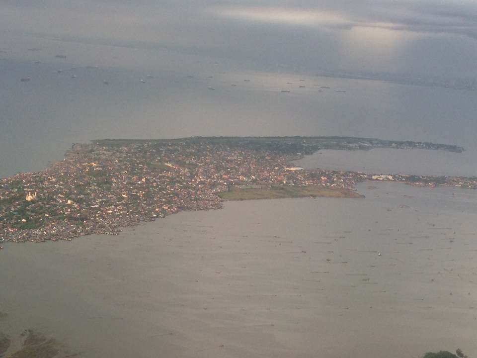 A closer look shows the strip of land that’s pretty much just the runway and a few buildings that serve as terminal and offices.
Whether the proposal for a future international airport at Sangley Point takes off (pun intended) or it is decided that Clark will be the main gateway for what has become a Greater Capital Region (Mega Manila) remains to be seen. There is actually a couple of other proposals put forward before including a site in Bulacan (north of Metro Manila) and at Laguna de Bay (south of Metro Manila). These proposals have basically faded in discussions and only Clark and Sangley Point remain in active consideration. Clark is already there and has a master plan with 3 runways and a huge passenger terminal while Sangley is still basically a concept for the transformation of a small air base and with lots of uncertainties/risks involved especially in implementation. Perhaps what will be for Clark’s advantage and the tipping point is the Bases Conversion and Development Authority’s (BCDA) proposal for a Clark Green City located nearby. The success of this new city is seen partly to be anchored on Clark becoming the main gateway and in tandem with NAIA. In my opinion, this can and would work (and would likely be more cost effective) if the government commits itself to Clark and the required infrastructure to support the airport. This can also help decongesting Metro Manila with a major development in Clark Green City, which is already in the works in as far as BCDA is concerned. As for Sangley, perhaps the question is not whether we can do another Haneda but if we can do it right and within a reasonable time frame given the complexity of the task at hand.
–
The numbers that matter – some thoughts on data
Too often we are bombarded with statistics, numbers that are supposed to describe the state of things. This is especially true in transportation and traffic where there seems to be a lot of information or data circulating about all kinds of stuff usually including numbers of vehicles, speeds, quantities of people and goods transported, and so on.
There is a tremendous amount of data collected by many government agencies. These include traffic counts by the DPWH, port and airport statistics by the PPA and CAAP, and socio-economic data from all over the country by the NSO. There is also wealth of information that can be derived from various project reports whether these be infrastructure master plans or evaluations of policies and programs related to transport and traffic. Local governments that require transport impact studies for developments within their jurisdictions are supposed to compile the data contained in these reports, which include traffic counts and projections at roads and intersections, transport facilities inventories, and travel time and delay data among others essential for impact analysis.
Origin-Destination (OD) data are important for planning transport from the national to local levels. Inter-regional, inter-provincial or inter-city OD data for people and freight are essential for planning infrastructure that would be able to adequately and efficiently handle the traffic between regions, provinces and cities/municipalities. As it is impractical (i.e., costly) to determine the exact numbers of traffic for all modes on a very frequent basis, sampling is very important and the determination of sample size as well as the sectors and areas to be sampled are essential aspects of any study. The current MMUTIS Update and Capacity Enhancement Project (MUCEP) that is the long-delayed follow-up to the Metro Manila Urban Transportation Integration Study (MMUTIS), for example, required household information surveys (HIS) for an area that is now referred to as Mega Manila, which is basically comprised of Metro Manila, Region 3 and Region 4A. Such a large study area necessitates careful sampling in order for assumptions regarding the data aggregation and disaggregation to hold.
Often, for many studies concerning cities and regions, person trip and freight volume data are more valuable than vehicle trip data. Though vehicle volumes are important, the number of people traveling or the amount of goods being transported are a better basis for planning transport. This is especially true for passengers as it is desirable to have the numbers as the basis for determining the frequencies (how often and with what schedule) and capacities (vehicle size/passenger capacity), which need to be balanced or optimized according to the demand. This demand is variable throughout the year and the day and will definitely have implications on revenues. There are desirable schedules for passengers as well as for goods. Moreover, it is important to determine also the trip distances that would allow for the estimation of the number of trips in terms of passenger-km and ton-km units. Such information are useful for travel demand modeling and forecasting including the evaluation of suitable transport modes and service characteristics for passengers and freight.
[to be continued]
–
Inappropriate designs for pedestrian overpasses
There was a photo that circulated in social media the last two weeks showing electric and telephone cables coming out of the stairs of a steel pedestrian overpass. It was obvious that the people responsible for both the overpass (MMDA) and the cables (power and phone utilities) did not coordinate their work and so people had to risk electrocution to be able to cross the street at what is assumed to be a busy intersection. Such is an example of unsuitable designs and bad implementation of infrastructure projects; in this case, that of a pedestrian facility. There are many other examples of these flawed execution of projects including electric posts in the middle of lanes after road widening projects, short span pedestrian overpasses that are not utilised by people (preferring to cross at ground level) because the road was narrow in the first place. Many are a waste of resources considering they may not have been required in the first place if careful assessment were made about the situation.
The pedestrian overpass under construction at the Masinag junction (photo below) is a good example of what looks like flawed design. The elevated walkway is narrow and is located right at the corners of the intersection. The width is important here because there are many people usually crossing at Masinag and the overpass can become congested for users. The stairs have not yet been constructed but if past designs of overpasses like this is to be considered, the stairs will likely be steep and therefore difficult to use for senior citizens, PWDs and children. Note, too, in the photo that the bridge already obscures part of the traffic signals previously installed at the intersection. This means the lights would have to be reinstalled or transferred so motorists can clearly see the signals.
 Pedestrian overpass under construction at the Masinag junction in Antipolo City
My friends at the DOTC tell me that it is only a matter of time before the Line 2 Extension project is bidded out an construction finally goes underway. Depending on the the final design of the line and end station, there might be a need to revisit the pedestrian overpasses along Marcos Highway. Hopefully, they don’t become like the overpasses along EDSA that had to be raised more due to the elevation of the Line 3 facilities including the catenary for the trains. I’m sure there is a suitable design for pedestrian facilities for crossing the wide Marcos Highway. It only requires careful thinking and creative minds to come together to come up with the appropriate facilities.
–
Compromising on the common station(s) for the Metro Manila rail lines
It seems that the issue regarding the common station for Line 1, Line 3 and the future Line 7 in the North EDSA area has not yet been resolved. The interested private sector parties, Ayala and SM, will not back down on their arguments support each’s proposal for the common station to be located at either of the giant malls that each corporation owns. Ayala’s claim is that the contract for the Line Extension to Cavite stipulates that the common station with Line 3 should be at Trinoma. Meanwhile, SM is claiming the validity of an agreement it made with DOTC on a grand central station to be located across their SM City North EDSA mall. The last one is consistent with an even earlier agreement with the proponents of the future Line 7 for an end station in front of SM.
A compromise solution to the impasse should be in the works and is the responsibility of the DOTC. What if instead of one common station, two stations are made into common ones? There will be no grand central station in the sense that all three lines will terminate as presented in SM’s version nor will there be a common station for Lines 1 and 3 at Trinoma that incorporates a very long walkway to a Line 7 station near Mindanao Avenue. Instead there can be two common stations – one at SM North for Line 1 and Line 7, and another at Trinoma for Line 1 and Line 3. Line 1 will still terminate at Trinoma but can have another stop at SM North where there can be a smooth transfer between Line 1 and Line 7, which terminates at this station. Perhaps there should still be a walkway connecting the two common stations in the interest of pedestrians although seamless fare collection systems and platform design can easily allow Line 7 or Line 3 passengers to ride Line 1 trains between stations to transfer to Line 3 or Line 7.
The common station or stations (depending on what will finally come out of this) should be designed thinking of the best interests of the public who will be using the transit systems and stations. Lost in the discussions are the plight of commuters. Parties claim that their designs are in the best interest of commuters (actually SM has the better set-up of all three lines terminating at one central station) and yet the bottomline for their arguments are very much revenue oriented – not for the transit lines but for their own commercial developments. Its basically one mall vs. another, leaving out the public as incidentals in the discussions. This is why government must intervene and this is where DOTC should show it has a spine after all and is promoting the public good and not favoring one private company over another. And so we’ll wait and see what will eventually come out of this although a lot of people continue to suffer with their inefficient commutes and are definitely becoming more impatient about mass transit systems that should have been constructed a long time ago.
–
Congestion due to roadworks at Sumulong-Olalia
The Sumulong Highway sections emanating from its intersection with Olalia Road have been experiencing traffic congestion in the mornings the past few days due to road works being undertaken at the intersection, and along Olalia Road and the Masinag-bound side of Sumulong Highway. Some days, traffic has been bearable and its just like having an ill-set traffic signal at the intersection where it would take you several cycles before getting through. Recently, however, many motorists have lost patience (or probably are simply pasaway) and have been encroaching on the opposing traffic lanes, much to the dismay of those who opted to follow rules. This panggugulang or going ahead of others need to be lessened with those guilty being apprehended or turned back to discourage future transgressions of traffic rules.
 Counter-flowing vehicles towards the Sumulong-Olalia intersection
 Queue at the curve towards the direction of Olalia Road
 A look at the side mirror shows a long line of vehicles along Sumulong. The queue sometimes reaches the strip of stalls selling cashew, suman, and other local delicacies.
There’s really very little one can do about traffic management in the area considering the limited space available for vehicles turning to/from Olalia Road. It’s basically one-way at the approach to Sumulong Highway so there will definitely be a queue along the outermost lane of Sumulong due to the constriction at Olalia. However, in the morning, there is an obvious difference in the directional distribution of traffic along Sumulong with most vehicles moving in the direction towards Masinag rather than to Antipolo Church. That means the Antipolo-bound traffic can fit along a single lane while opposing traffic can use three lanes – 2 bound for Masinag and 1 for Olalia. Enforcers may want to use traffic cones for this temporary traffic management scheme as without such tools, there is a tendency for a bit of confusion as impatient drivers resort to encroaching on the opposing lane (counter-flow) and resulting in more severe congestion (and unsafe conditions) as they attempt to merge with traffic at the intersection. Of course, that goes without saying that it only takes one idiot to counter-flow for others to follow.
–
The Metro Manila Urban Transportation Strategy and Planning Project (MMUTSTRAP, 1983)
I continue on my feature on past studies on transport in Metro Manila. The Metro Manila Urban Transportation Strategy and Planning Project (MMUTSTRAP) was conducted from November 1982 to April 1983, with support from the Australian Development Assistance Bureau – the precursor of AusAID. The study was conceptualized by a Metro Manila Transportation Policy Committee that consisted of the Ministers of the then Ministry of Transportation and Communications (now DOTC) and Ministry of Public Works and Highways (now DPWH), the Vice Governor of what was the Metro Manila Commission (now MMDA), and the Chief of the Philippine Constabulary/Integrated National Police (now PNP). The Philippine Government-funded study examined alternative futures on Metro Manila’s development and used these as the basis for formulating alternative futures for public transport modes. These futures did not mention UTSMMA and its the recommendations for an RTR but presented pessimistic, most likely and optimistic scenarios for PNR, LRT bus and jeepneys.
The study examined recommendations of past studies, most specifically the more recent MMETROPLAN and MMUTIP. MMUTSTRAP seem to contradict MMETROPLAN’s recommendations to encourage the entry of new bus and jeepney operators rather than restricting or controlling these as it (MMUTSTRAP) concluded that “deregulation is not a viable alternative for urban public transportation in Metro Manila.” It further explained that deregulation is justified on the assumption that the main objective in urban public transport is simply to make it a profitable business. To the contrary, the study pointed out that there are other objectives such as adequate service to the public and safety, which should be placed above profitability. This last statement reverberates over the decades to the present when it seems to many that the objective of urban public transport is more on the “profit side” rather than the “adequate and safe aspect” of something that it supposed to be a public service.
The study explored strategies for traffic management and various travel demand management (TDM) measures including area traffic restraint similar to what Singapore had already implemented at the time. A significant output of MMUTSTRAP was a prioritization plan for transport projects and policies for Metro Manila. This included the ranking of projects for implementation in Metro Manila such as:
- Pending road projects
- Potential road projects
- Urgent traffic signals
- Potential pedestrian projects
- Potential transit projects
- Terminal projects
Examples of the transport projects ranked by MMUTSTRAP are shown in Tables A and B for pending road projects, and potential transit projects. An index was developed based on perceived importance of the project and the associated costs.
Table A – Ranking of pending road projects identified in MMUTSTRAP (1983)
| Brief description | Rank | Index |
| Visayas Avenue extension: Elliptical Road to C-6 | 1 | 66.4 |
| Mindanao Avenue Extension: North Avenue to C-6 | 2 | 66.1 |
| C-5 construction: MacArthur Highway to North Expressway | 3 | 64.0 |
| Makati-Mandaluyong Link Road | 4 | 61.4 |
| Loop Road: from Bicutan to Alabang | 5 | 61.2 |
| C-6 construction: North Expressway to M. Marcos Avenue | 6 | 61.1 |
| Widen R-10: C-1 to Dagat-dagatan Spine | 7 | 60.7 |
| C-3 construction: Rizal Avenue to G. Araneta Extension | 8 | 60.5 |
| C-3 improvement: G. Araneta to Aurora Boulevard | 9 | 59.5 |
| Widen South Superhighway | 10 | 58.7 |
| C-4 interchange with Boni Avenue | 11 | 58.6 |
| C-5 construction: R-4 to Pasig Boulevard to Aurora Boulevard | 12 | 58.5 |
| R-4 construction: EDSA to Pasig/Pateros | 13 | 57.9 |
| R-5 construction: Kapasigan to Taytay Diversion | 14 | 57.7 |
| C-5 construction: North Expressway to Aurora Boulevard | 15 | 56.2 |
| C-3 works: Ayala Avenue to Tripa de Gallina | 16 | 55.9 |
| C-3 construction: N. Domingo to Ayala Avenue | 17 | 55.7 |
| Widen Domestic Road: MIA Road to Airport Road | 18 | 55.5 |
| C-4 extension: Taft Avenue to Roxas Boulevard | 19 | 55.3 |
| C-4 interchange with Roosevelt Avenue | 20 | 55.2 |
| C-4 interchange with Ortigas Avenue | 21 | 54.7 |
| C-4 interchanges with Ayala Avenue and Pasay Road | 22 | 54.1 |
| C-4 interchange with Santolan Road | 23 | 53.7 |
| C-4 interchange with Kamias/East Avenue | 24 | 53.2 |
| C-4 interchange with Buendia Avenue | 25 | 52.2 |
| C-5 construction: R-4 to South Superhighway | 26 | 52.1 |
| Widen Parañaque to Sucat Road | 27 | 51.8 |
| Re-align western 1.6 km of Zapote-Alabang Road | 28 | 49.3 |
| R-10 Construction | 29 | 49.1 |
Notes: The codes C and R stand for Circumferential and Radial, respectively, and refer to the main road network of Metro Manila. These roads are more commonly known by other names such as, for example, EDSA (C-4), Aurora Boulevard (R-6) and España Boulevard (R-7).
Table B – Ranking of potential transit projects identified in MMUTSTRAP (1983)
| Brief description | Ranking based on assessment by project team | Ranking based on evaluation from selected MOTC panel | Index |
| Bus replacementa | 1 | 1 | 55.6 |
| PNR Commuter additional coaches and upgrade | 2 | 2 | 50.8 |
| LRT Line #2 – EDSA | 3 | 3 | 44.4 |
| Surface tramway – Radial road along Españab | – | 4 | 43.9 |
| LRT Line #3 – Radial along España | 4 | 5 | 43.0 |
aAssumed that additional bus units will not be needed in the next 5 years with replacements likely after 1987.
bProject proposed by one of the members of the MOTC panel. This was treated as an alternative (on a mutually exclusive basis) to LRT Line #3, rather than an independent project for ranking.
[Reference: MMUTSTRAP, 1983 – NCTS Library]
Earlier studies recommended projects but did not show lists ranking projects in terms of an objective index or criteria. MMUTSTRAP did a good job in coming up with this idea or basis that was transparent and objective in evaluating projects. The criteria, however, is based mainly on perception of those involved in the study and, arguably, such perceptions may vary according to the knowledge and experiences of those involved in the evaluation. This is where the biases lie in as far as project prioritisation was concerned for this project. Perhaps a more participatory approach could have been conducted? Of course, it can be argued that at this time, both capacity and capability of local governments and national agencies were quite limited and so these have to be dependent on consultants (i.e., the study team) for their assessment and recommendations.
–
