
Tutubi bike share at BGC
I had been curious about the ADB-supported bike share initiative they called Tutubi since it was launched at the University of Sto. Tomas (UST) in Manila and at Bonifacio Global City (BGC) in Taguig. These have sophisticated portals where one can rent a bicycle by simply swiping or tapping your card unto the terminal. I finally noticed the bike station at Bonifacio High Street in BGC. I don’t know how I missed it since we are there weekly but then there are usually events in that area and the bike share station may have been obscured. Following are a few photos I was able to take as I watched our toddler walking about curiously and excited of the fountains and others she found interesting at High Street.
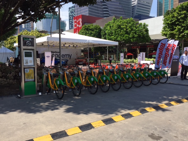 All the bikes seem to be here as not a slot was vacant.
 It seemed ironic to see not one bike in use against the backdrop banners of a popular motoring magazine.
 A closer look at the portal shows what looks like a new (unused?) facility.
It seems to me that there are few users of the Tutubi at least at Bonifacio High Street. I wonder if the bikes at UST are utilized more than the ones at BGC. I also wonder if UST is monitoring or studying bicycle use in its campus. Its use being limited within the premises of the campus sort of restricts users and diminishes utility. UST has a walkable campus and while its area is big (20+ ha) compared to other universities and colleges in the University Belt district, it is smaller beside Katipunan neighbors Ateneo De Manila University (80+ ha) and the University of the Philippines (493 ha). The latter two are also “walkable” with UP having more park-like features and open to the public.
UP Diliman has its own Bike Share program run by students and (I might come as biased) these seem to be popular on campus as I see many of the bikes used by students to go around from one building to another. UP Bike Share currently employs a more conventional system including subscriptions for frequent users. There is, however, a Department of Science and Technology (DOST)-funded project through the Electrical and Electronics Engineering Institute of UP Diliman that hopes to develop a more sophisticated system for managing and monitoring the bikes. That project has just started so we might wait 1 to 2 years to see its fruits.
–
Oversupply of vehicles for ridesharing/carsharing – Part 2
This is a follow-up on the recent post on ridesharing/car sharing where I talked about my observation that there seems to be an oversupply of vehicles being used for what is claimed as ride-sharing or car-sharing. In that post, I mentioned an observation by me and my colleagues that popular ride-sharing/car-sharing companies like Uber and Grab have led to more vehicles on the roads. I add to that the findings of our students that:
- Those shifting to Grab and Uber are mostly those already using taxis (regular users) and those using UV Express, which is a higher capacity vehicle using either vans or AUVs (average passenger capacities between 10 and 18 passengers).
- GrabCar and Uber function more as premium taxis rather than ride-share or car-share modes.
A friend who’s among the first Uber drivers in the country (He was already an Uber driver before the explosion in the service’s popularity.) shared that Uber earlier had been a real car-share/ride-share. My friend’s full time job was as a musician and he thought of becoming an Uber driver only to have some additional income for when he wasn’t busy with his work or didn’t have gigs. He was not roving around Metro Manila to get fares much like what is now being done by many Uber and GrabCar units.
Later, when Uber and Grab began more aggressive marketing; promoting their services as potentially generating much more income than conventional taxis and perhaps even a person’s full-time job, people started purchasing cars not for their use but to use in business in the form of Uber and Grab cars. I can probably understand those who bought cars and drove the cars themselves. To me, these would still qualify as ride-sharing/car-sharing but on the upper limit of what we can really consider “sharing” since they are supposed to be driving during their free times. Arguably, unemployed people have the entire day as free time compared with employed people or those who run businesses other than being Grab or Uber drivers. These include housewives and even “househusbands” who may have a vehicle at home that they can use for Uber or Grab. Employed people can only share their rides during the time they go to their offices or when they travel home later in the day. Others may have more free time as business people would likely have more flexible schedules.
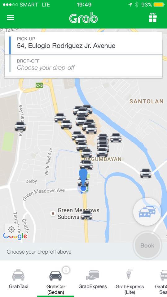
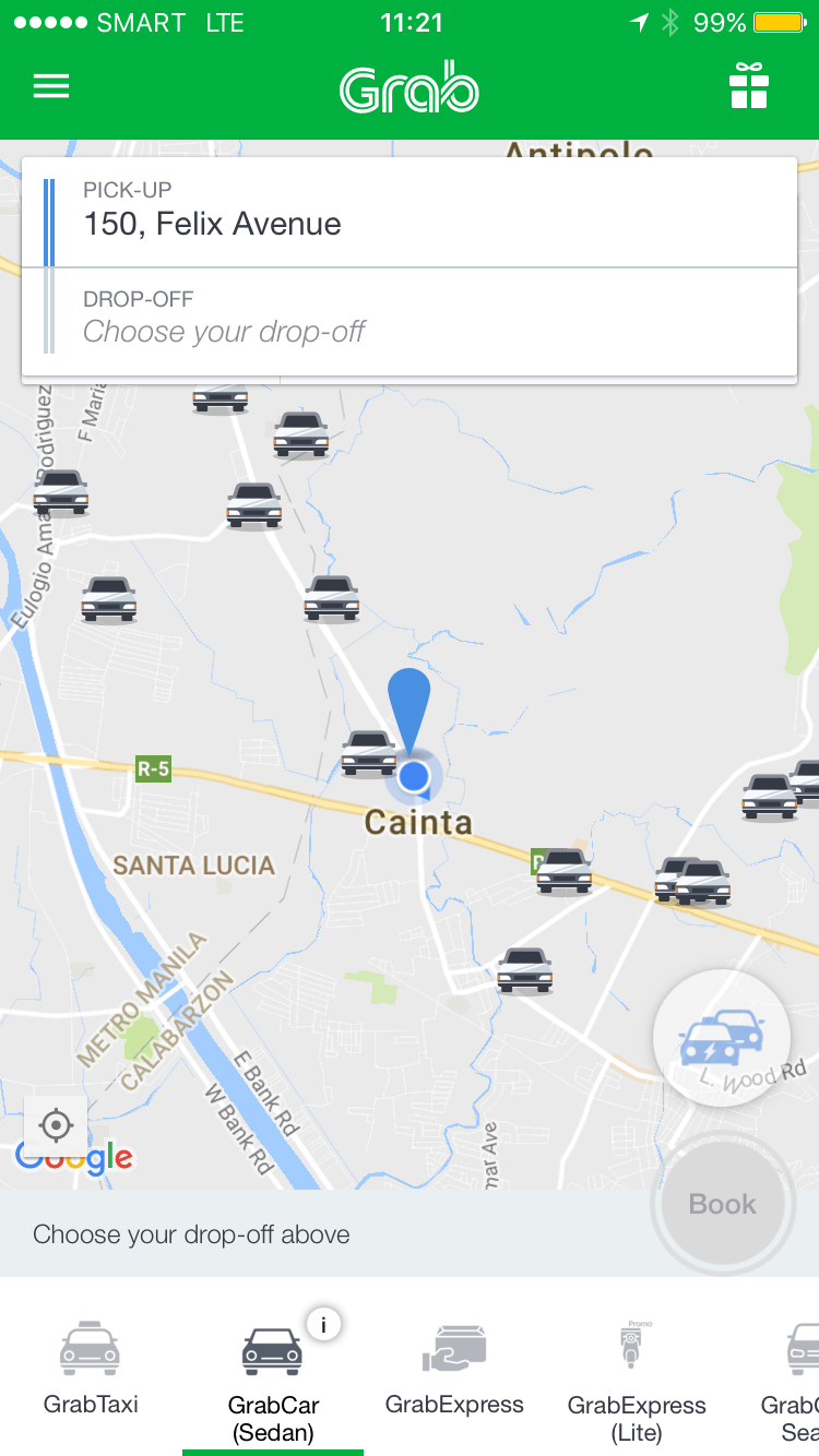
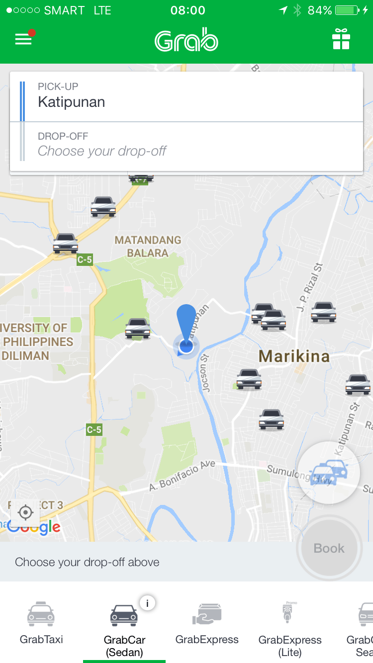
Following is a series of screenshots I took en route to a meeting. It is, I believe, more systematic in terms of trying to determine the availability of vehicles – in this case GrabCars. Again, correct me if I’m wrong about my assumption that the vehicles displayed represent available cars. If they do not then it means the app is misleading people into thinking there are available cars for them to hire.

Grab Cars in the vicinity of UP Diliman
 Grab Cars in the vicinity of Eastwood
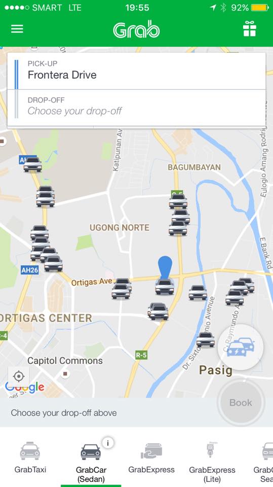 Grab Cars in the vicinity of Tiendesitas
 Grab Cars in the vicinity of Cainta Junction
–
Global Street Design Guide
Here’s another quick post. I just wanted to share this article with a link to a Global Street Design Guide that was developed by the National Association of City Transport Officials (NACTO) in the United States (US). It’s a nice guide that’s based on the experiences of many cities in the US including transformations that have made commuting more efficient, enhanced mobility and, most important of all, improved safety. Following is the link to a more direct link to the guide:
NACTO and the Global Designing Cities Initiative Release Global Street Design Guide
This will be a good reference in the Philippines where many cities are in need of transformation to address current and future challenges in transportation. Planners, engineers and students should read this and use it to make our streets safer and more efficient in terms of mobility for all. It would be nice to see fresh ideas on how we can improve our streets not just in Metro Manila but elsewhere across the country. Of course, it would be nice if city planners of local government units (LGUs) can adopt this design guide parallel with efforts to improve public transport services. It should be understood that simply imposing lane allocations and traffic flow policies (one way?), for example, will not solve problems but may create more. The approach should always be integrated, inclusive. In other words, complete.
–
Metro Manila public transport – addition is good but we need subtraction, too
The company providing the P2P bus services is very enthusiastic (aggressive?) in promoting their services especially via social media. Satisfied commuters have also shared their experiences and a lot of photos about the buses and their commutes through social and mainstream media. I have read some articles carried by the likes of Rappler and Inquirer as well as blogs relating about the buses features, what people liked about the service and their suggestions on how to further improve and expand services. These have provided commuters with a taste of how good public transport could be in terms of quality of service.
The operations and the operator seems to have the blessings of the Department of Transportation (DoTr) and not just the present administration but from the previous one when the P2P services started. The fact that they have expanded services further these past few months is a testament to their popularity and the demand for high quality public transport services in Metro Manila. I personally believe that the next step is to give these buses exclusive lanes along their routes. Such would allow for buses to travel faster and providing a significant decrease in the travel times of commuters. Current operations, despite having non-stop runs between origin and destination, run in mixed traffic so their impacts in terms of travel times are diminished. Also, with exclusive lanes, they can probably consider adding a few stops between the route ends and be able to simulate bus rapid transit (BRT) services of which there seems to be little appreciation so far in the Philippines.
While the new buses and routes are very welcome and provide attractive options for commuting, there is still a need to address what is perceived as an over-supply of buses, jeepneys and UV express vehicles in Metro Manila. The attractiveness and higher service quality of P2P buses can pave the way for reducing the numbers of buses, for example, along EDSA. A similar strategy of introducing high quality bus services along other corridors and then reducing bus, jeepney and UV express units there can be implemented but will require much in terms of political will. The latter is important when dealing with operators and drivers of displaced vehicles, who may oppose such transport reforms and probably throw in legal impediments including those pertaining to franchising. Whether such opposition can be addressed by emergency powers or not remains to be seen but hopefully, even without such powers, the government can engage the transport sector to effect reforms and improve public transport (and ultimately commuting in general) not just in Metro Manila but in other cities as well.
–
Oversupply of vehicles for ride-sharing/car-sharing – Part 1
My students recently concluded studies on popular ridesharing/carsharing services Uber and Grab. The studies details how, for example, people have come to prefer Grab Taxi, Grab Car and Uber over regular taxis. One important finding and conclusion in one study is that Uber and Grab in the Philippines cannot be considered as contributing to sustainable transport. Note that this conclusion is just for the Philippine case and perhaps can be further constrained to Metro Manila since all data collected was with the geographical bounds of the metropolis.
There is already a perception that there is an oversupply of vehicles being used for what is being claimed as ride-sharing or car-sharing. This is due to the surge in new vehicle purchases as people joined the Grab/Uber bandwagon. Who can resist the opportunity to earn good money from being a Grab or Uber driver? That is basically the question answered by a lot of people who decided to purchase cars and register these and themselves for Grab or Uber.
To see if there is some truth to this perception of oversupply, we use one ride-sharing app for the information it provides users. One can make a quick check of how many Grab vehicles are moving about and ‘looking’ or waiting for riders/passengers. Following are what’s displayed on my phone in three random instances last Tuesday for GrabCar. I leave it up to the reader to draw conclusions from these screenshots.

More in Part 2…
–
Of accomplishments and legacies in transport
My colleagues and I have been talking about accomplishments and legacies. In particular, we had a spirited discussion about what we have been doing in terms of transportation projects that we have been involved in. I think everyone wants to have something physical to remember them by. And these should be positive and constructive and not memories of controversies or anomalies like those in major projects that will be associated with corruption or abnormalities in the processes by which the projects were implemented.
The ‘problem’ with being involved in policy making and planning is that these often lead to outputs such as reports and maybe even laws. If one is lucky enough then perhaps its in the form of a legislation rather than a Department Order. But those legislations and memos often do not acknowledge the people who contributed to its drafting. They will be associated with the politicians (e.g., senators and congressmen) and officials (e.g., secretaries, undersecretaries) who sponsored, co-sponsored or issued them. It will be good to have some sort of evidence to show and prove that you were instrumental in planning, designing and/or implementing a project.
The appointment of a new Department of Transportation (DoTr) Secretary in Art Tugade had me recalling our meeting with him to present the outcomes of our study on a major commercial development at Clark Freeport. He was appreciative of our work and mentioned that Clark had implemented many of the recommendations of the Master Plan we had developed for the Freeport back in 2010. All the major recommendations were implemented during Tugade’s watch at Clark. Following are the most notable ones:
 The Mabalacat Gate and Public Transport Terminal of the Clark Free Port Zone
 McArthur Highway – M.A. Roxas Highway – First Street rotunda
 Clark Freeport main gate
The lead for these projects was Dr. Ricardo Sigua who is the one of the leading transportation engineers in the Philippines and currently the Director of the Institute of Civil Engineering of the University of the Philippines Diliman. He is also the head of the Road Safety Research Laboratory of the National Center for Transportation Studies where he is also a Research and Extension Fellow. Others involved in these projects were Dr. Karl Vergel, Dr. Noriel Christopher Tiglao and Dr. Jose Regin Regidor, all from UP Diliman and affiliated with the NCTS.
–
Sparing the trees
The Department of Public Works and Highways (DPWH) embarked on a major road widening project in the last administration. This continues today. One of the issues raised then was the cutting down of many trees along the roadside to give way to one additional lane along each direction of national roads. While conservationists and environmentalists were not successful in provinces like Tarlac where old camachile trees were cut down, the case in Pangasinan seems a bit more positive. Traffic along rural highways such as the Urdaneta-Calasiao-Dagupan Road can become heavy but not so much so that it requires two additional lanes to the original two. As such, while the shoulders can be paved as part of the lane widening program of the DPWH, the trees can actually be spared. I think the DPWH and the LGUs would just need to mark the trees to make them very visible at night time or when visibility is low along the highway.
 Big old trees, mostly mango trees line up the Urdaneta-Calasiao-Dagupan Highway along the newly paved lane that used to be a shoulder of this highway. These huge trees are fruit bearing and so one can imagine that part of the loss if these were to be cut down were the tons of mangoes that many people could benefit from.
 Sections of the additional lanes are generally not usable for general traffic and revert to their previous use as parking spaces. These paved sections now also are useful as ‘solar driers’. Shown in the photo above is an example where grains of rice (palay) are laid out direct on the concrete pavement for natural drying under the sun. People (staff of the owners) guard these against animals, wayward motorists and possibly thieves. These staff will gather the grains when there is impending rains or when the day’s almost over to dry another day.
I wanted to take more photos of the highway but was seated at the back of our van so I had to settle for a few select shots. The second photo above is care of a colleague who sat in front and took a few shots himself.
–
Data on local roads – digital maps
Here’s another quick reference to an article describing a current undertaking to map the 45,000+ kilometers Philippine road network:
PH undertaking $5M digital mapping of 45,000-km road network
What’s significant with this development is that soon the country will have excellent maps, including 3D and 360-degree views of most if not all local roads. While there are similar maps via Open Street Maps and Google Maps, the latter are not as comprehensive. These maps will be very useful for a lot of applications including transport planning, urban and regional planning, and disaster mitigation. A lot of people are surely looking forward to the completion of this project as well as when the maps can be accessed and used.
–
Extreme commutes on a jeepney
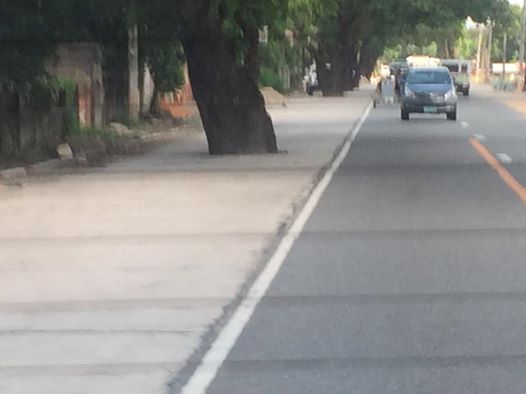
I chanced upon this overloaded jeepney along Sumulong Highway. I counted eight people hanging behind the vehicle including the conductor. This is actually illegal and not just at present but always. The practice of hanging behind a jeepney is obviously unsafe and there is a high risk of people falling off. It would be a miracle not to have major injuries if one falls from the vehicle, and there is a high likelihood of fatality especially of a falling passenger gets hit by another vehicle trailing the jeepney.

‘Sabit’ or hanging on for a jeepney ride is more a necessity and males usually do this in order to get a ride home or to work. On many occasions, you will see men or boys in their office or school uniforms in the morning, braving it just so they won’t be late for work of school. While it is illegal, authorities seem to apprehend overloaded jeepneys from time to time (or according to some, just for show). I guess they, too, understand how difficult it is to get a ride and how this somehow allows people to get to their destinations. Surprisingly and despite reckless behavior among drivers, there seem to be few untoward incidents reported. Hopefully, public transport will improve so that people will not have to do such extreme commuting.
–
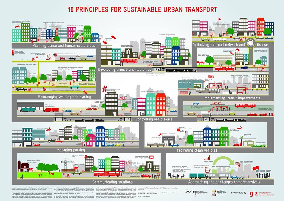
10 principles for sustainable urban transport
We start October with a graphic on sustainable transport. I first saw this shared on social media (FB) by the Clean Air Asia. The organizations behind it are on the graphic itself so I don’t have to list them down for the reader. This is a good material to share and learn from especially for those who don’t have a clear idea of what sustainable transport is and is all about. As they say, pictures paint a thousand words. And illustrations such as this convey so much about sustainable transport in the urban setting in layman’s terms.
–
