
On low income cyclists
There are two articles that I want to share here. These are quite interesting for me as they tackle something not usually written about when it comes to cycling. The “invisible biker” referred to in one of the articles is the typical low-income cyclist. These are those who can be seen regularly using their bicycles to commute to and from their workplaces; likely to save hard-earned money for more important items such as food and shelter (rent?). They do not use fancy bicycles like those nice, branded mountain, road or fat bikes that you see being used by recreational bikers or weekend cyclists. They most likely use second-hand bikes like those surplus bicycles from Japan, or perhaps old BMX’s that have been modified to make it a bit more comfortable for the long commutes.
Quednau, R. (2017) The Invisible Bike Riders, Strong Towns, http://www.strongtowns.org, May 2.
Koeppel, D. (2015) How Low-Income Cyclists Go Unnoticed, Bicycling, http://www.bicycling.com, November 9.
I think these are the bike riders that we should be providing safe bikeways for. They are the ones who most often use bicycles for their trips and are at risk of being hit by motor vehicles.
–
Construction starts for the Line 2 Masinag Station
After several months of waiting, the Masinag Station of the Line 2 Extension project will finally start construction. The contractor has already mobilized and very soon the actual construction work will be starting. Following are photos I captured via my dash cam:
 The contractor, DMCI, already installed temporary traffic signs from Masinag Junction.
 The contractor, DMCI, also already installed concrete barriers to delineate their staging area for the project.
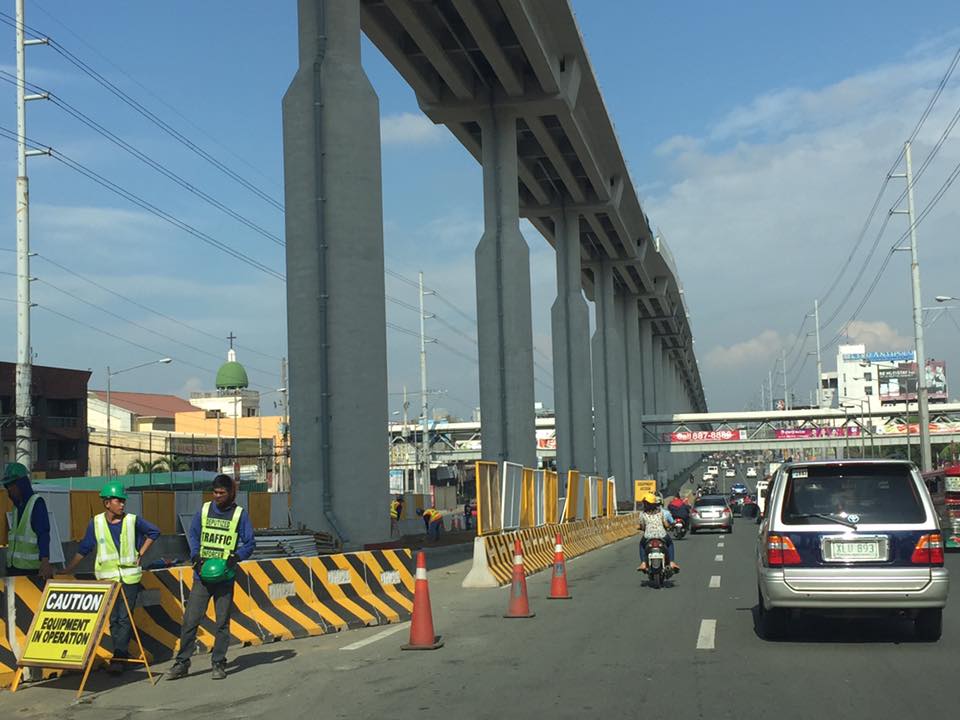 This is the likely location of the elevated Masinag Station; right across SM City Masinag and Cornell Hospital.
Masinag Station will probably be the highest station for any railways in the entire country judging from the height of the elevated tracks. I have yet to see the plans for this station but it should be a challenge in accessibility. How many steps would it take to go up or down the station and the platforms? How will, and will it be integrated with the surrounding developments like SM?
The Antipolo City Government’s official Facebook page already announced the official ceremony starting the construction to be held on May 30, 2017 (Tuesday). The advisory also cautioned travelers about the traffic congestion expected in the area affected by the construction. Masinag is a major junction where Marcos Highway and Sumulong Highway intersect. Construction period will be 18 months or 1.5 years but given the efficiency by which the same contractor was able to complete the elevated tracks, I am optimistic that they may be able to complete Masinag Station in less time. I wonder though if the ceremony tomorrow also includes the start of construction for the Emerald Station across Robinsons Metro East in Pasig. Let’s just hope that the Line 2 Extension will be operational by end of 2018 and be able to help alleviate the traffic woes along its corridor. This will definitely help improve the transport to the east of Metro Manila and directly benefit those from Antipolo and Cainta in Rizal, and Marikina and Pasig in Metro Manila.
–
Landscaping for the LRT Line 2 Extension
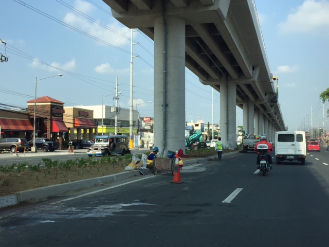
A friend posted about the removal of trees along the median of Commonwealth Avenue as part of the construction of the MRT Line 7 in Quezon City. Many if not all trees in the Fairview area have been cut or balled. A similar thing happened during the construction of the Line 2 Extension from Santolan, Pasig City to Masinag, Antipolo City. All the plants and trees along the median island were removed to give way to the construction of the elevated tracked of Line 2. Recently though, as the median has been cleared of construction materials and equipment, landscaping work was implemented. This makes sense considering there is enough space to make the area underneath the elevated tracks green. Trees and other plants can grow here providing a natural barrier for traffic as well as to improve the overall environment along Line 2.
Following are photos taken as we passed by Marcos Highway, taken a few weeks ago. Some of the plants have survived and but many seem to have simply dried up. Wha seems to be the early arrival of the wet season should help bring life to the plants under the elevated tracks of Line 2.

–
On e-tricycles again
This is also another late post. I was driving in Tagaytay when I spotted these electric tricycles near the junction of Aguinaldo Highway and the Tagaytay-Nasugbu Road. It was the first time for me to see these e-trike models that obviously got inspiration from the tuktuks of Thailand.
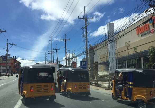
Counterflowing, racing, or maneuvering just about anywhere their drivers seem fit mean these e-trikes are operated just like their more conventional relatives. While their deployment are supposed to ease air pollution attributed to the exhausts of conventional tricycles, these likely will not contribute to easing traffic congestion in Tagaytay. I wonder though if these e-trikes are replacing the conventional ones. Many LGUs seem to have embraced e-trikes but as additional units to the current ones comprised of legal and illegal (colorum) trikes. Too often, LGUs are too careful in phasing out the old tricycles fearing a social backlash that can affect votes whenever there are elections. And so they could not properly address public transport issues directly pertaining to tricycle operations leading to worsening transport and traffic conditions especially in the CBDs.
–
On walking and the old pedestrian overpass at UPIS
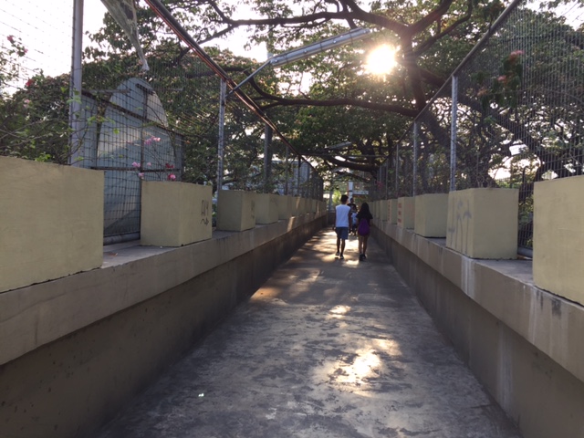
I decided to go for a long walk one day last April. I walked from our office to the UP Town Center, which was just under 2 kilometers away, to purchase something. I could have taken my car or perhaps rode a jeepney but I wanted to see for myself how easy or difficult it was to walk that distance. It turned out that it wasn’t a difficult walk at all. From Melchor Hall, I crossed the street so that I could walk along the inner part of the Academic Oval. I then took a short cut through the trail in front of Malcolm Hall at the edges of the Sunken Garden, emerging just near the grandstand. From there, I crossed towards Vinzons Hall and then walked towards and along Shuster Street near UP Integrated School. I exited the campus at the portal at the end of Shuster and crossed Katipunan using the old pedestrian overpass that connected the main campus with what used to be UPIS on the other side of C-5.
 The pedestrian overpass is an old structure compared to many of its kind around Metro Manila. The design is quite massive considering it is a concrete structure. The photo above was taken towards the direction of UP Town Center.
 The steps are quite steep on either side of the overpass
 Here’s a photo of a person carefully walking down the steps of the overpass.
 The photo above was taken towards the direction of the UP campus.
The overpass used to be dirty, unkempt, and to many was revolting enough that it was rare to find people using it to cross Katipunan. Most people crossed the busy thoroughfare on the ground, often braving the traffic and taking on the risk of getting hit by a vehicle. Since the overpass was integrated with the UP Town Center (i.e., it is physically connected to the mall and there security personnel posted there), more people now use it. MMDA also fenced much of the median of Katipunan in the area and so the only way to cross the stretch of UP Town Center from Shuster to C.P. Garcia is via either of the two pedestrian overpasses (there’s a second, newer steel structure near C.P. Garcia).
As for the walk to Town Center and back, I thought it was safe, convenient and invigorating (nothing like some walking to help in blood circulation). I took a leisurely pace (not brisk) for my walk so I could enjoy the environment. You tend to see a lot of things when you take such walks and the campus is full of activities, sights and sounds, to help make the walk enjoyable such that you won’t even notice the time and perhaps, won’t even mind the exercise.
–
Pavement distress along C-5 due to the truck lane policy
I frequently use Circumferential Road 5 (C-5), which is known by many names according to the MMDA, the DPWH and the LGUs it passes through. One thing I always notice is the deteriorating or deteriorated pavement, particularly along the lane designated for use by trucks. The MMDA had instituted and implements a policy requiring large trucks to use one lane of C-5 during times when the truck ban is lifted (10:00 AM to 4:00 PM). Smaller trucks are allowed to use other lanes.
The result has been a long platoon of large trucks along the designated lane of C-5 and this concentration of load on the highway has caused faster pavement deterioration for that lane. This is especially evident when the pavement surface is of asphalt concrete. Flexible as it is, the concentration of load has led to obvious pavement deformation as shown in the following photo.

For Portland cement Concrete pavement (PCCP) cases, I would presume that there is also significant damage and the distresses (e.g., cracks) can be linked to this concentration of load. This situation and the conditions for loading likely have detrimental implications on maintenance costs for C-5 and is probably an unintended consequence of the MMDA’s policy. It would be interesting to quantify the impacts of this truck lane policy, whether it has contributed to improve traffic flow along the major thoroughfare, and whether the maintenance costs have risen (and by how much) from the time the policy was implemented.
–
New publication on urban transport by ITDP and UC-Davis
There is a new publication on urban transportation from Institute for Transportation and Development Policy (ITDP) and the University of California-Davis. The link may be found here:
Three Revolutions in Urban Transportation

The content reminded me of similar exercise we did back in 2013-2014 for ASEAN where we did visioning and simulations for low carbon transport in the region by 2050. Electrification was a major assumption for the Philippine case as electric vehicles were gaining ground (they seem to be in a limbo now) back then and on the verge of a breakthrough. Not yet evident for the Philippines was the eventual rise of sharing, and though the idea is out there, automation seems to be too high tech for the country (even Metro Manila) for now.
–
Wheel “chaining” in Taytay, Rizal
Another municipality that has become somewhat aggressive in its campaign against illegally parked vehicles is Taytay also in Rizal province. In the case of Taytay, instead of wheel clamps, authorities have opted to employ what appears as more cost efficient (read: less expensive) tools in their campaign – chains and locks. Instead of the more sophisticated (and likely more expensive) wheel clamps in neighboring Antipolo, chains are wrapped around one of the front wheels of a vehicle and then secured by a lock. Examples are shown in the following photo:
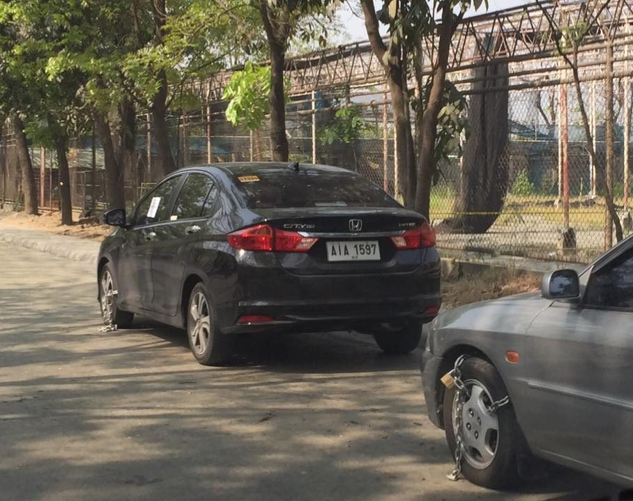 Car wheels chained and padlocked along Don Hilario Cruz in the Taytay Public Market area. The road connects the Manila East Road with the new Taytay municipal hall complex.
Anti-illegal parking enforcers also post a sheet of paper on the window of the vehicle to notify the driver about the violation. The enforcers are posted nearby; waiting for drivers to approach them. There’s supposed to be a fine similar to when a vehicle is towed and reclaimed by the driver or owner. This, campaign, however, seems to have been relaxed in the same area where I took the photo as there are again a lot of vehicles parked on either side of the street on the Saturdays that I pass by the area. I’m not yet sure if this is a case of ningas cogon on the part of the municipality or perhaps they are just exercising some flexibility considering the parking demand for the market and the numerous clothes shops there where wholesalers flock to for merchandise. I haven’t seen similar “chaining” activities in other parts of Taytay unlike Antipolo, which has been continuously and consistently conducting campaigns throughout the city.
–
Wheel clamping in Antipolo
Earlier this year, Antipolo City implemented an aggressive campaign against illegal on-street parking. This policy was borne out of a new ordinance penalizing on-street parking that has been perceived as the cause of traffic congestion along many of the city’s roads. A more detailed description of the conditions or situations warranting wheel clamping may be found in the Antipolo City website.
The following photos were taken from the Antipolo City Government Facebook page:


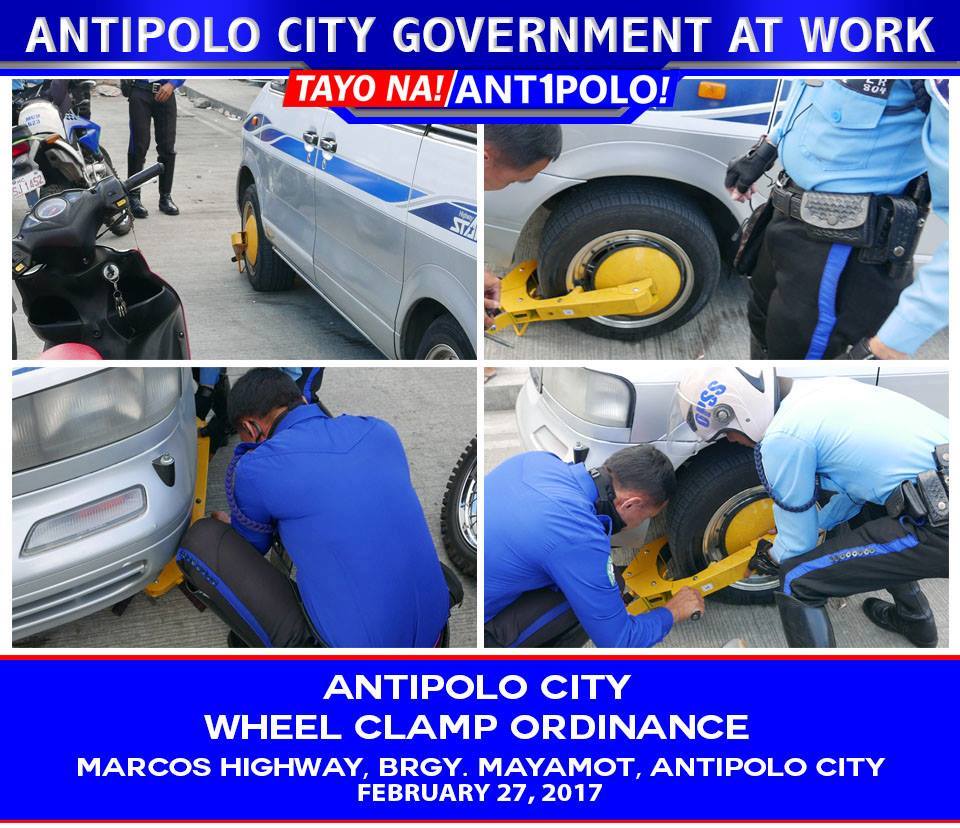
The ordinance and its implementation by the city is very timely (some may say overdue) considering that many streets particularly in the city center is already clogged with vehicles parked on-street. In certain cases, there’s double parking; severely constricting traffic flow even along one-way streets. There are (as always) evidence of resistance but hopefully, the city’s resolve will overcome and improve the situation.
I think another thing that should be in Antipolo’s agenda that’s very much related to the problem of on-street parking is the requirement for off-street parking spaces as stipulated in the National Building Code. The Code actually prescribes for the minimum number of slots per building or development but it is the local government that is tasked to implement or enforce the provisions in the NBC. Going around Antipolo, one can observe that there are many establishments clearly in violation of the Building Code provisions. One major university, for example, along Sumulong Highway does not have enough spaces considering the vehicle trips it generates. This situation is compounded by the expansion of the school to include a hospital and the adjacent commercial development that conspicuously also appears to not have enough parking spaces. An LGU can actually have a policy for stricter minimum parking slots. Quezon City and Makati City have ordinances stating so but have had mixed results compared to the outcomes they probably thought about as desirable.
Of course the topic of minimum parking spaces is currently the subject of discussions in other, more progressive cities and countries, and particularly those with better developed public transport and more disciplined land development. While relevant to us here in the Philippines, it is a topic that is not yet ripe for serious discussions given the many concerns (i.e., violations, non-compliance issues) that still need to be addressed by LGUs like Antipolo City at present.
–
Newly opened sections of C-6
I have been wanting to post these photos of the newer sections of Circumferential Road 6. The section was constructed months ago and is part of a project that seeks to widen the current stretch of C-6 from Taguig (Lower Bicutan) to Pasig (Napindan) from the old 2-lane, 2-way road into a 4-lane, divided road. The new section opened to general traffic along the southbound side (to Taytay) and has improved traffic along the section that’s provided people from Rizal an alternative route to Makati and BGC through Taguig. Only, light vehicles are allowed along the new section and trucks and other heavy vehicles take the old road, which is quite battered by the traffic. Only one lane is currently available as there are barriers along the section as shown in the following photos. Traveling along the section also afford people a nice view of the Laguna de Bay to the right.


–
