
What happens now to the DOST’s AGTs?
The Automated Guideway Transit (AGT) vehicles that were used in the research and proof of concept at the previous test site in UP Diliman are scheduled to be transported back to DOST’s MIRDC soon. The vehicles are still in UP Diliman and are usable for R&D if someone decides to come up with a viable proposal for these. Unlike the hybrid electric train that is the AGT’s contemporary in terms of them being parallel projects, the future is unclear for both AGT models (i.e., there is another, higher capacity AGT already at MIRDC and tested using the test tracks there).
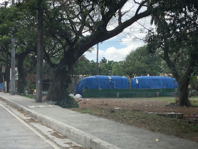 The two AGT vehicles are wrapped to protect them from the elements. These are functional and should still have value in case someone proposed to continue in their testing and refinement. It doesn’t need to be an elevated guideway for development to continue.
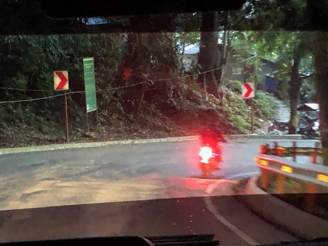
 Here’s a closer look a colleague managed to take before we turned at the intersection.
What’s next for the AGT? Is there a future for these vehicles? Will the DOST initiate something with the DOTr or maybe with an LGU (Taguig?) to come up with a project that will employ these vehicles in what can be a full system instead of one on test tracks? Let’s hope these assets can still be utilised and not be wasted.
–
Another look at the Bitukang Manok
I recently featured photos of the old zigzag road along the Pan Philippine Highway that is more popularly known as the “Bitukang Manok”. Those photos were taken on an early morning while we were on our way to Bicol earlier this month. Following are photos of the old zigzag road taken on the afternoon of our return trip to Manila.
 Crossroads – at the intersection at the southern end where travellers decide whether to take the Bitukang Manok or the newer and easier bypass road
 The sign states: Vehicles with 6 or more wheels are prohibited from using the old zig-zag road.
 Sign for the Quezon National Forest Park – this designation is attributed to a former President and local congressman
 Here’s a photo of one of the more challenging sections. A team of flagmen manage traffic by giving turns to either direction, ensuring slower speeds and wider turning at the hairpin curve. Travelers often toss coins as a token of gratitude for these flagmen who man this challenging section of the national highway 24 hours/day.
 The barriers and signs along Bitukang Manok have been upgraded and are well-maintained.
 Approach to the northern end of the old zigzag road
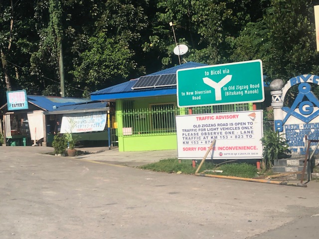 Directional sign at the other end of Bitukang Manok showing the options for travellers and another advisory stating the prohibition of large vehicles along the old zigzag road.
–
On the P2P bus service between Antipolo and Ortigas Center
I decided to take the P2P bus from Robinsons Antipolo to Robinsons Galleria earlier this week. For one, the opportunity presented itself as I had meetings in the Ortigas Center area that day. Second, I didn’t want to drive in heavy traffic along Ortigas Avenue and the area. And third, I didn’t want to worry about parking (my meetings were not necessarily in buildings located near each other). I could easily walk or take a taxi (or Grab car) between meetings without having to worry about a parked car.
 Ticket/receipt issued upon payment of the 60-peso fare
 The bus was empty but for a few passengers when I boarded. I initially took as seat near the door but then saw the sign by the window stating that the first two rows of seats are preferably for persons with disabilities, senior citizens and others who may require these seats for convenience.
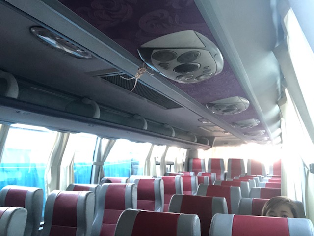
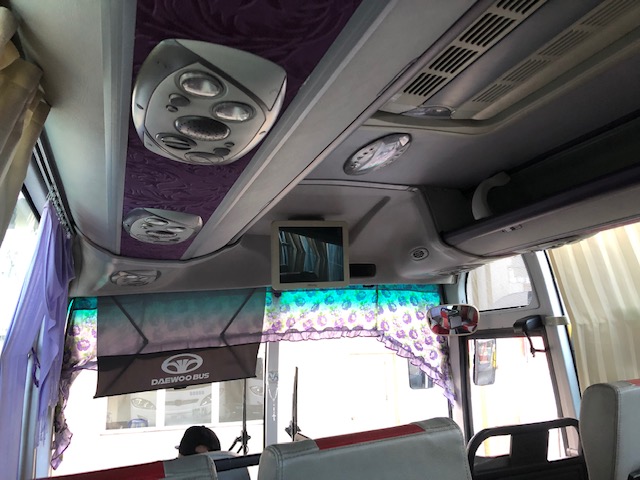 The bus I rode on is of Korean make (Daewoo) and a recent model based on the design and condition of the interiors. The air-conditioning was also strong so most passengers just close the aircon ducts above them.
 There’s a bus leaving every 30 minutes. There is a no standing policy so passengers will be directed to the next bus once all seats are taken, even if there’s a lot of time remaining before the full bus departs.
 Nearby the bus terminal is a jeepney terminal for the Antipolo-Cubao (via Sumulong Highway) route. Tricycles freely come and go at the terminal. Meanwhile, people may also leave their vehicles at the parking area (free of charge) for the final legs of their daily commutes. These allow for practically seamless transfers between different modes of road transport.
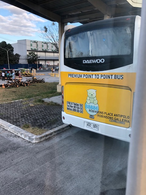
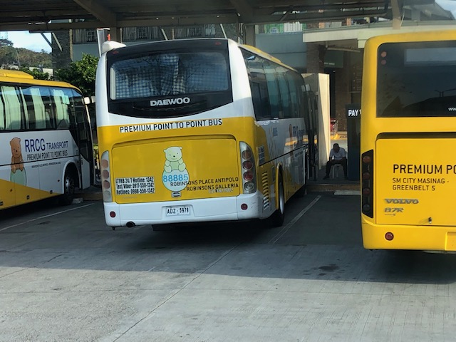 There are several buses at the terminal when I boarded in the morning. I wonder how many are committed to this particular route but the sign on the body of one bus stated that it was for the SM City Masinag – Greenbelt 5 route. I guess the Robinsons Place Antipolo terminal serves as a waypoint for these buses, which are deployed from the RRCG terminal in Taytay.
The trip started at 7:30AM and took about 75 minutes between Robinsons and Medical City, where I alighted from the bus. I figure it could have been about 1.5 hours until Robinsons Galleria if I continued to the end of the route. I actually thought I had to alight at Galleria but then noticed a couple of passengers who requested the driver to let them out at Medical City. Traffic was moving very slowly along that section of Ortigas Avenue and it wasn’t really an inconvenience to the rest of the passengers for a quick stop at Medical City.
And so I quickly changed plans and alighted at the hospital where I figured I could easily get a cab to my first meeting near Shaw Boulevard. I was right and and quickly got a Grab car to my first meeting. I just walked to the next meeting before taking another P2P bus to get home. The bus ride was comfortable and one can even have a short nap without much worry about security as the bus does not stop for most of the route (i.e., with the exception of the Medical City stop). You can easily squeeze in some work as I saw a couple of passengers typing away on their notebooks. Commutes have become difficult to many that the service provided by these P2P buses present a comfortable option to many who could afford it. The P2P buses actually provide services that are supposed to have been delivered by vans (i.e., FX, GTE, UV Express, etc.) but the latter has evolved to be more like an air-conditioned jitney rather than an express service in urban areas. Hopefully, these P2P buses can retain their quality and level of service and it attracts more car users. I suspect that their passengers might be those who are already using public transport and just shifted to one with a higher level of service.
–
On the Tandang Sora flyover’s closure
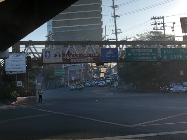
The signs announcing the closure of the Tandang Sora flyover along Commonwealth Avenue are doing the rounds of social media. So are the traffic management plans (i.e., the re-routing maps for the area) that are being shared by many and soliciting a variety of reactions. The reactions are often angry or sad for those likely affected by the closure and the re-routing via Luzon Avenue, Congressional Avenue and Philcoa. The demolition of the flyover to give way to the future MRT-7 station will definitely lead to traffic congestion and longer travel times to a lot of commuters, whether using public or private transportation. However, there are only few comments so far about the impacts on pedestrians. Will the pedestrian footbridges be demolished, too? Will they be redesigned or replaced considering the high volume of pedestrians crossing this major intersection? Following are photos taken underneath the Tandang Sora flyover as we waited to make a U-turn. These show the pedestrian footbridges in the area that allow people to safely cross the wide Commonwealth Avenue.
 View of the steel truss footbridge that goes underneath the Tandang Sora flyover
 There are many signs installed on the footbridge including the speed limit for Commonwealth Avenue and a reminder to fasten seatbelts. Others are directional signs including those designating the lanes for public utility vehicles and motorcycles.
 There is another steel footbridge that is of more recent design and construction connecting to the old truss bridge. This allows pedestrians to continue on to cross Tandang Sora. This example is actually one that invites questions pertaining to design. Why have two distinct designs instead of building on the previous one? Another case of “pwede na iyan” ?
 Here’s another view of the two footbridges – one spanning Commonwealth and the other across Tandang Sora. Will these be demolished, too, to give way to the MRT-7 station? And will the MRT-7 Station design include a provision for non-passengers to cross Commonwealth and Tandang Sora? This seems to be the most logical way to design the station; integrating pedestrian (and cycling) needs to the infrastructure. But then again, that remains to be seen and perhaps someone can share the design of the Tandang Sora station for this to be scrutinized.
–
Simulating cities?
I found this nice article about some of the most popular simulation games; especially SimCity:
Baker, K.T. (201 ) Model Metropolis, Logic, https://logicmag.io/06-model-metropolis/?mbid=nl_021119_transportation_list_p [Last accessed: 2/13/2019]
While there are still those who dismiss these as merely games, they fail to appreciate the really complex algorithms and processes that could now mimic real world situations. That includes governance of cities that is a very important factor to its development. Land use planning or transport planning alone cannot provide the solutions for a city’s problems associated with, among others, its growth. The success reflects on the administration and leadership that should be able to anticipate and respond to issues while consolidating and rationalising resources, which are often limited.
–
Marikina’s Bike and Parking Lanes
I had to navigate through Marikina’s streets in order to reach the Feliz Mall from the city’s downtown. Normally, I would have taken the more straightforward route that would have involved traveling along Marcos Highway. However, I couldn’t because it was my number coding day and the U-turn slots in the area are usually “swarming” with MMDA and Pasig City traffic enforcers. Marikina’s streets though were not part of the coding scheme and you only need to be familiar with their road network including which streets are one-way in order to navigate the streets properly.
 The bike lane is on the left side of the one-way road and to the right of the on-street parking spaces. The parking lane is the left-most and curb-side.
 This actually qualifies as an example of a road diet application. These could have easily been 2-way streets before but effectively 2 lanes have been allocated for traffic flow while the others are for parking and cycling. [Of course, hard-core cyclist will say only one lane was taken away from motor vehicles.]
These bike and parking lanes were implemented in connection with the Marikina Bikeways project that was initiated during the time of then Marikina Mayor Bayani Fernando in the late 1990s. The project was continued and maintained by succeeding administrations of the city and contribute to the city’s being more liveable compared to other LGUs. The reconfiguration of the streets make them safer and saner in terms of traffic flow where “traffic” is referred to as inclusive of all users.
–
More concerns about ride-hailing/ride-sharing
Here are two interesting (to me at least) articles about the negative aspects of ride hailing or ride sharing. The first is quite a curious one for me as I teach at UP Diliman, which has a sprawling campus in Quezon City. Students can have one class at a building on one end of the campus and have the next class at another end of the campus. I now wonder if there’s a significant number of Grab or Angkas trips within campus.
Kidambi, M. (2019) “Popularity of brief Uber, Lyft rides on campus raises environmental concerns,” Daily Bruin, http://dailybruin.com/2019/01/29/popularity-of-brief-uber-lyft-rides-on-campus-raises-environmental-concerns/ [Last accessed: 2/8/2019]
The second article relates on the a more general context of what’s bad about ride hailing/ride sharing. The author presents not just a list but evidence of each item mentioned.
Schmitt, A. (2019) “All the Bad Things About Uber and Lyft In One Simple List,” Streetsblog USA, https://usa.streetsblog.org/2019/02/04/all-the-bad-things-about-uber-and-lyft-in-one-simple-list/ [Last accessed: 2/8/2019]
As I’ve mentioned in previous articles here, there are still a lot we need to learn about ridehailing in this country and especially in our cities. I guess Angkas’ case can be different because motorcycle taxis were already operating in many areas even before the app-based service. But of course, we also need to understand about his enhanced ‘habal-habal’.
–
Bitukang Manok
I woke up from a long nap just before we entered a major zigzag section of the Pan Philippine Highway that is more popularly known as the “Bitukang Manok”. That literally translates to “chicken innards or intestines”, which is how many travellers would describe the alignment of this section of the national highway network. We decided to take the “old zigzag road” instead of the “new diversion road” since the latter is known to be already congested especially as trucks and buses take this road instead of the zigzag.
 Expectedly, the road offered all kinds of curves and grades throughout. I was glad to see relatively new barriers already installed or constructed along the entire length of Bitukang Manok.
 Here is a particularly challenging section combining sharp hairpin curves with steep inclines.
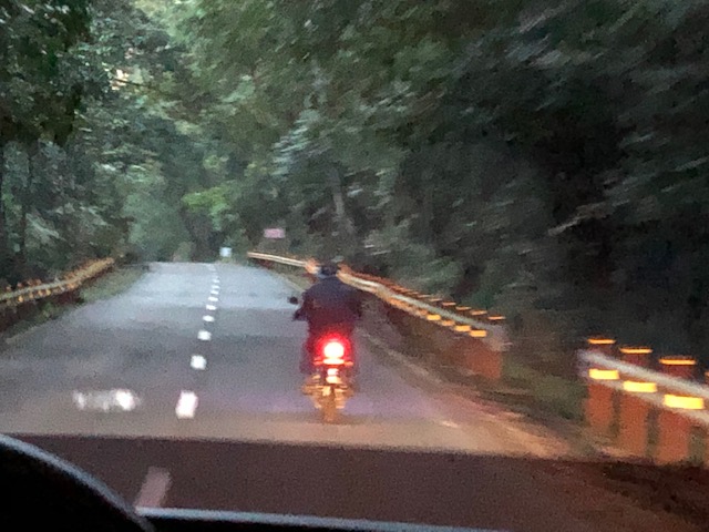 We caught up with this rider along a relatively straight and level segment of the road
 There are flagmen strategically deployed along the most difficult parts of the road including this one that might lead inexperienced or erring drivers to drive/ride straight off a cliff.
 Here’s another hairpin curve; this time on the way down from the mountain.
 The final turn of the road before it merged with the diversion road
 Sign at the other end of the road showing travellers the divergence of the national highway into the “old zigzag road” and the “new diversion road”. Notice the platoon of southbound trucks at right.
I remember Bitukang Manok as a dreaded section among travellers before not just from the safety viewpoint but also because many can get sick (e.g., motion sickness that may result into throwing up) going through the section especially if the driver is not as smooth in manoeuvring the vehicle through the zigzags. There were also long distance bicycle races before where the Bitukang Manok featured as the main challenge to the best cyclists and the winner of that leg of the race was pronounced as “king of the mountain”.
–
Some snapshots of the PNR ROW along the way to Bicol
I promised to post about my trip and here are a few photos I took of the PNR’s right of way (ROW) showing the railways crossing with the Pan Philippine Highway (Asian Highway 26 or AH 26) at many points.
 After traveling in the early hours of the morning, we finally got a good glimpse of the PNR’s south line that basically runs parallel to the national highway.
 The single track line will actually go underneath the bridge downstream from where this photo was taken. I just couldn’t get a clear shot from our vehicle. I hope to get one on the way back.
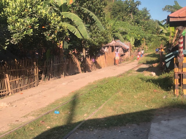 Railway tracks are currently used as access to communities with dirt roads often running just beside the tracks.
 Railway tracks leading to what looks like an area that still has a lot of vegetation. Note, too, what looks like check rails in the photo.
 Railroad crossing signs along the highway – the standard one is obvious in the photo
 Much of the PNR’s ROW has encroachments making it unsafe for modern railway operations.
 An obviously unused (dormant?) part of the line in Quezon
The government plans to upgrade or rehabilitate the PNR’s Main Line South with the help of funding (and technical assistance?) from China. A colleague opined that maybe since the north line rehab is to be undertaken with the help of the Japanese, then perhaps the south should similarly be rehabbed with the help of Japan. That should ensure the same quality and standards will be applied throughout the system. What do you think?
More photos and stories soon!
–
On conducting a national travel survey in the Philippines
There’s a nice article about the National Household Travel Survey regularly conducted by the US Federal Highway Administration (FHWA):
Lewin, M. (2019) “Learning from the National Household Travel Survey,” http://www.planetizen.com, https://www.planetizen.com/node/102508?utm_source=newswire&utm_medium=email&utm_campaign=news-02042019&mc_cid=03588de77e&mc_eid=9ccfe464b1 [Last accessed: 2/6/2019]
There is a lot to learn from such surveys and especially if historical results can be compared in order to establish trends and issues. I recall that we attempted to engage the then National Statistics Office (NSO) back in 2005 for them to include certain items in the national census but for the purpose of data collection for inter-regional passenger and freight flow. That didn’t bear fruit but perhaps it is about time to reconsider and for the Philippine Statistics Agency (PSA) to include questions specific to travel in the census.
Ideally, of course, is to have our own national travel survey where we can obtain data not just for inter-regional or even inter-provincial or inter-island passenger and freight transport characteristics. Data from a national household travel survey would give us details on a lot of things including but not limited to the following:
- Average commute data – e.g., commute travel times & commute distances for those taking private or public transport
- Vehicle ownership data – e.g., car, motorcycle and bicycle ownership and usage
- Travel cost data – e.g., various cost components for traveling via private or public transport
Such information can be categorised a number of ways like according to age, gender or income. It will definitely help us understand how people travel including their perceptions and choices. It can help formulate solutions to a lot of issues, transport and traffic-related, that cities and municipalities are trying to address. Of course, this will definitely involve big data but this is not a new thing, and large data sets have been used in many transport studies including those for Metropolitan Manila (e.g., MMUTSTRAP, JUMSUT, MMUTIS, MUCEP) and the inter-regional study (SIRPAFF) we did a decade and a half ago. The advantage now is that we have more sophisticated tools for analysing such data.
–
