
On using Google Maps to determine the best route from the pollution perspective
I saw this article on digital maps (i.e., Google Maps) being used to determine the best route for traveling between an origin and destination on land. It is interesting because what we usually use as basis for selecting our routes (assuming we can do so since people taking public transport basically have fewer options due to PUVs having mostly fixed routes) are travel time, travel distance and travel cost. Here is the article discussing the addition of fuel efficiency and emissions to the criteria:
Calma, J. (July 25, 2023) “People are using Google Maps to cut down tailpipe pollution,” The Verge, https://www.theverge.com/2023/7/24/23805652/google-maps-fuel-efficient-routes-transportation-emissions [Last accessed: 7/29/2023]
To quote from the article:
“According to Google’s own analysis, many drivers are taking the path of least pollution in their cars. To calculate the tailpipe emissions that prevented, the company compared how much fuel Maps users likely consumed on the routes they drove to how much fuel they would have burned through had they taken the fastest route without its eco-friendly routing tool. The savings amounted to 1.2 million metric tons of avoided CO2 emissions between October 2021, when Google launched the tool, and December 2022.”
While this seems to be a first foray into the including of eco-friendly items in route choice, these items are already and actually included in many travel planners including those used by people selecting which flights to take. We probably just didn’t notice them before or the information were not explicitly stated or posted. Would this really affect or influence the way we travel like how it is reported in the article? Or do we continue to go with the usual and familiar routes?
–
Bike lane master plan for Metro Manila, Metro Cebu and Metro Davao
The Department of Transportation (DOTr) with support from the United Nations Development Program (UNDP) yesterday formally launched the Bike Lane Master Plan for Metro Manila, Metro Cebu and Metro Davao. Yesterday’s event was actually the third and last leg of presentations, which were also made in Cebu and Davao. Here are a few photos I got from the DOTr Facebook page (these are public):
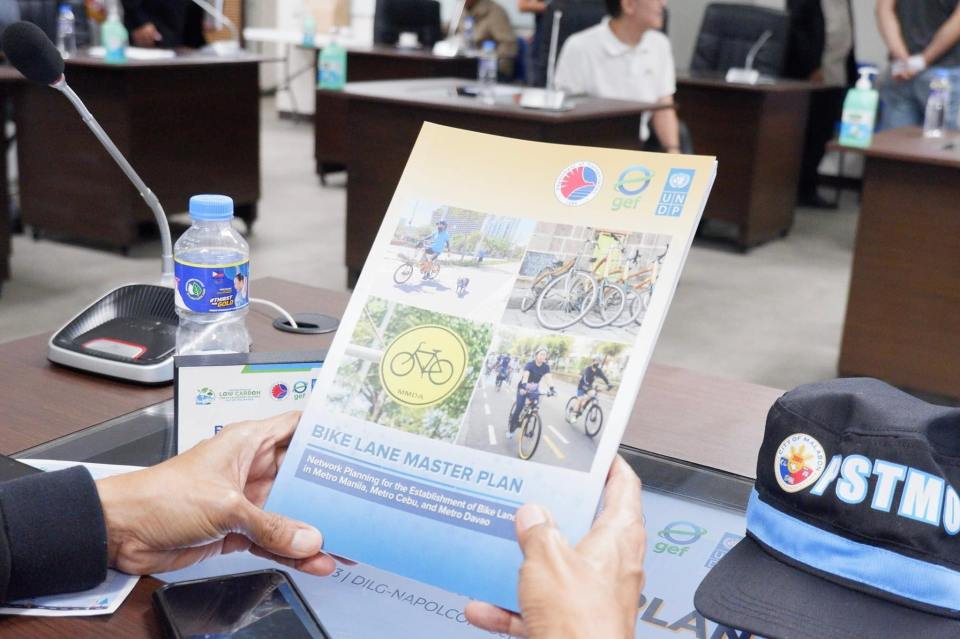 Printed copies of the master plan were distributed to attendees (Photo: DOTr Facebook page)
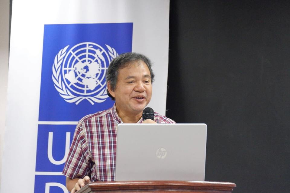 Dr. Ricardo Sigua of the National Center for Transportation Studies presented the highlights or key features of the master plan. The UNDP engaged NCTS to conduct the master planning project for DOTr. (Photo: DOTr Facebook page)
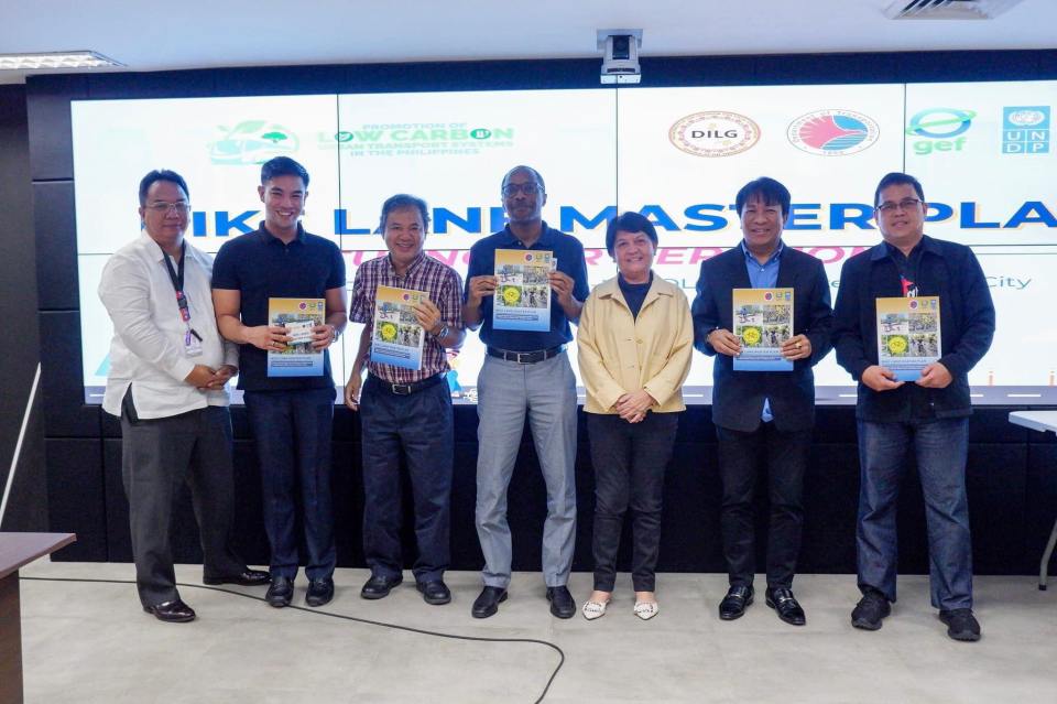 Photo op with participants from the MMDA (Photo: DOTr Facebook page)
While the master plan is most welcome as the country continues to build infrastructure for active transport (mainly walking and cycling), the launch is actually one year late. The project was actually completed last year and though most of the recommendations have yet to be carried out, many items including the inventories are already dated. These master plans though should not be static documents but dynamic in these sense that it would have to be updated regularly. For one, updates would provide the opportunity to reinforce or improve certain aspects of the plan. Updates also provide an opportunity to check whether progress is being made on the targets set in the plan. Also, since the master plan is for three metropolitan areas perhaps it can be part of the foundation for a nationwide plan. However, many plans fail if there is not support or scarce resources allocated for the implementation. Thus, there is a need for resources or allotments especially coming from government to support the realization of the plan.
–
Tricycle policies in Zamboanga City
I forgot about these photos I took at the driveway of a shopping mall in Zamboanga City. The tarps state the penalties for erring tricycle drivers in the city under a couple of City Ordinances (185 and 485, series or year not stated in the tarp) and the fare matrix based on City Ordinance 416 (series or year also not stated).
 Penalties for erring tricycle drivers in Zamboanga City. As stated in the tarp, the typical offenses include: overcharging, refusal to convey passengers, insolent, discourteous or arrogance, undue preferences or unjust discrimination, and operation of motorized tricycle for hire in prohibited areas. It is also clear that the penalties are not just for drivers but the owners/operators of the trikes with erring drivers.
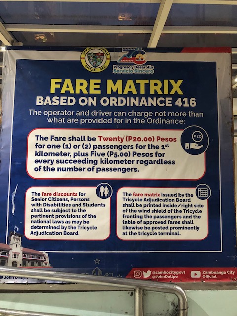 Simple fare calculation stated on the tarp. I assumed there were specific matrices posted in each tricycle but there was none since operations are free-for-all regardless of TODA in the city. That is, trikes in the city practically have no zones of operation where they are restricted or confined similar to what they have in other cities like Olongapo or Quezon City. In the latter, they can issue specific matrices or tables for the passengers’ reference much like what you have in jeepneys that have fixed routes. This can be confusing to passengers and creates situations that may lead to drivers taking advantage and overcharging passengers.
In a city like Zamboanga where there are many one-way streets, tricycle drivers can easily lengthen or appear to lengthen trips leading to overcharging of fares. Where tricycles do not have zones or areas of operations per TODA, this becomes the weakness or flaw even with ordinances in place for erring drivers and a simple fare matrix for passengers’ reference. Of course, regular commuters should be familiar with the usual fares they pay so perhaps that’s among the basis for knowing if you’re being overcharged. Visitors though will likely pay more if the driver consciously takes advantage of the situation. Again, this is a matter for enforcement of the ordinances passed by the city and an example of how such ordinances will be implemented.
–
Transport strike again?
There’s a 3-day transport scheduled starting tomorrow when the current President delivers the annual State of the Nation Address (SONA). The reason is reported to be to protest the government’s Public Utility Vehicle Modernization Program (PUVMP). I wrote a 4-part series on these strikes earlier this year and stated that such actions have been diminished over the years especially with government and its agents learning how to use conventional and social media to their advantage. That is, if you have a troll army at your disposal, you will definitely use it and take advantage of the commuting public’s growing perception (as influenced by government’s narratives) that the strikes are unnecessary and based on unfounded gripes. So the blame goes to the drivers and operators and the organizers rather than on the government agencies even despite the legitimate arguments by the former. In this case, it’s supposed to be about PUVMP but most commuters are indifferent about supporting the strike as it can be viewed as vs. modernization of public transport, which people link to improvement (i.e., modernization = improvement).
Here is the link to the last and concluding article in the series:
A brief history of transport strikes – Part 4: impacts and implications
I think my conclusion and the observations I presented in the series still holds. Given the resources and the alternatives to counter the potential impacts of a strike, going through with one presents a likely failure to get support from commuters in general.
–
On concert and sports event venues being accessible to transit
Among the major concert or sports event venues in the Philippines, perhaps the Araneta Coliseum is the most accessible to public transportation. Others like the SM Mall of Asia Arena in Pasay City is accessible to public transport but only for road-based modes. The Philippine Arena in Bulacan is accessible only by private transport or shuttle vehicles (basically also private as they are leased or rented). Compare this to say Singapore’s National Stadium, Tokyo Dome or Saitama Arena, which are all served by mass transit systems. It was so easy to go to the U2 concert in Singapore or Japan because of this. It was difficult for the same when they came to the Philippines because going to the Philippine Arena required a long drive both ways.
With all the fuss about Taylor Swift’s concert tour, I found this article about how fans or Swifties as they are called get to the concerts – they take public transportation:
Brady, T., Caldera, L. and Worthington, P. (July 14, 2023) “Transit Funding Problems Too Big Even for Taylor Swift to Solve,” Next City, https://nextcity.org/urbanist-news/transit-funding-problems-too-big-even-for-taylor-swift-to-solve?utm_source=Next+City+Newsletter&utm_campaign=c480374b80-DailyNL_2023_07_14&utm_medium=email&utm_term=0_fcee5bf7a0-c480374b80-44383929 [Last accessed: 7/19/2023]
To quote from the article:
“And how did the nation’s Swifties get to these concerts? As a recent Crain’s article explains, transit.
Fans took buses and trains to see superstar Swift, adding 43,000 bus and rail rides in Chicago and tripling the number of weekend riders in Atlanta. Her Philadelphia concerts in mid-May brought an estimated 27,000 additional riders to SEPTA’s (Southeastern Pennsylvania Transportation Authority) subway line next to Lincoln Financial field.”
If she held at least one concert here, I’m afraid that concert will generate more car traffic than transit ridership if held at the Philippine Arena. NLEX will definitely generate a lot of toll revenue but traffic will be hell for the event.
–
On weird weather’s impact on air travel
With the wet season comes a lot of thunderstorms and there have been increasing occurrences of lighting alerts around Ninoy Aquino International Airport (NAIA) that led to the grounding of many planes. That resulted in long delays and surely an inconvenience to a lot of passengers. It looks like ‘weird’ weather or extreme weather events are here to stay and may even become worse as we continue to grapple with climate change and warmer weather. I am sharing a recent article about this here:
Hoover, A. (July 13, 2023) “Weird weather is making air travel even worse,” Wired, https://www.wired.com/story/weird-weather-is-making-air-travel-even-worse/?bxid=5bd6761b3f92a41245dde413&cndid=37243643&esrc=AUTO_OTHER&source=Email_0_EDT_WIR_NEWSLETTER_0_DAILY_ZZ&utm_brand=wired&utm_campaign=aud-dev&utm_content=WIR_Daily_071323&utm_mailing=WIR_Daily_071323&utm_medium=email&utm_source=nl&utm_term=P4 [Last accessed: 7/14/2023]
Quoting from the article:
“But there are more complicated, invisible effects of a warming world too. Hotter air is trapped near the ground, and cooler air above. Shifts in temperature gradients affect the wind shear, or the changes in speed and direction between air near the ground and at higher elevations. These eddies create clear air turbulence, which occurs in the absence of clouds. Light turbulence can cause sudden changes in altitude that feel like bumps, but severe turbulence can cause structural stress to the aircraft.
Turbulence isn’t just unpleasant. It’s the cause of more than one third of injuries aboard air carriers, according to the US National Transportation Safety Board, and in rare instances can even lead to death.
Changing wind patterns may also alter flight lengths. If, for example, there are stronger eastward winds, flights from the US to Europe will speed up, but flights in the other direction may take longer. Transatlantic flights may even need to reroute and refuel.
Research from Paul Williams, a professor of atmospheric science at the University of Reading in the UK, found that jet stream changes could increase the amount of time flights are in the sky each day, leading to more fuel burning, higher costs, and more CO2 emissions. Jet streams are high-altitude air currents that drive weather systems. As the Arctic warms, the North Atlantic Jet Stream is changing, leading to more odd weather.
But heat alone can also lead to delays and cancellations, like when a 119-degree day in Phoenix grounded planes in 2017. That’s because high temperatures decrease air density. When the air is less dense, planes need more time and distance to fight gravity as they take off—so they may need a longer runway to become airborne. Not all airports can accommodate these sudden changes.”
–
Article share: What’s Incomplete About Complete Streets?
The concept of road diets circulated in Metro Manila more than a decade ago. I recall the Metro Manila Development Authority (MMDA) picked up the concept and attempted to apply it in some parts of Metro Manila. Since there are no evidence of that endeavor surviving now, then we can assume that it was a failure. There is no wonder there as I also recall the effort to be half-hearted and more to get media mileage (cheap talk or lip service) out of it. Road diets eventually evolved into the complete streets (though the literature now will state road diets as part of complete streets). That experience and similar initiatives of varying success (or failure) rates are not unique to the Metro Manila but is actually happening elsewhere including cities in countries where the complete streets have been applied more comprehensively and yet somehow found to be lacking or not as effective a solution as expected. I am sharing an article here that discusses what seems to be lacking or ‘incomplete’ as it is referred to.
Source: What’s Incomplete About Complete Streets?
Quoting from the article:
“What’s missing? First of all, even the best Complete Streets policy can’t solve the problem of fiscal scarcity. Even in a city committed to Complete Streets, street redesign must fight for public dollars with other worthy goals such as education and public safety. As a result, Indianapolis’s improvements are a drop in the bucket. The city maintains 3,400 miles of streets and roads, so its 100 miles of bike lanes affect only 3 percent of the city. Similarly, 2,000 miles of the city’s roads still lack sidewalks.
Second, the quantitative benchmarks seem to focus on sidewalks and bike lanes (Sec. 431-806), and the policy doesn’t mention traffic calming or similar policies. So if the city had a six-lane road with traffic going 60 miles per hour, the Complete Streets policy would not affect that road except to the extent necessary to build a sidewalk or a bike lane.** Thus, even the best Complete Streets policies don’t really address some of the most dangerous features of American street design.”
—
Heritage buildings in Makati City?
I noticed from last weekend’s view from our hotel room a couple of buildings that on their own could be considered landmarks in the city.
 The Makati Central Fire Station could easily qualify as a heritage structure or building considering its architecture and age. If we were in Singapore, the building would already be declared as a heritage structure.
 The Makati Central Post Office building is obviously newer but could be considered a landmark for the city.
If it was not obvious, these two are very much related to transportation. The fire station hosts fire engines or fire trucks that are the vehicles of firemen responding to emergencies, especially fires. The post office deploys mailmen and women on foot or vehicles to deliver the mail, parcels or packages. So its very much involved in logistics.
–
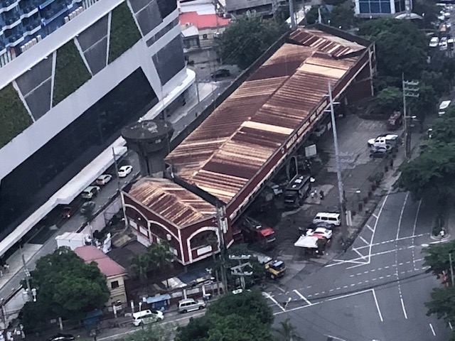
Counting cars: ideal vantage points for intersections and elevated highways
The weekend found us staying at a hotel in Makati in order to be near the recital venue for our daughter. Our room afforded a nice view of the surrounding areas (we were on the 29th floor) but the traffic engineer in me gave in to the temptation to take photos of a major intersection nearby – the Gil Puyat Avenue – Ayala Avenue intersection. These are two of the most prominent streets in the Makati CBD and strategically located at one corner is the Makati City Central Post Office and a stone’s throw away is the Makati City Central Fire Station. At another corner is the RCBC tower that hosts foreign embassies including the offices of the European Union.
 Intersection of Gil Puyat Avenue (formerly Buendia Avenue) and Ayala Avenue
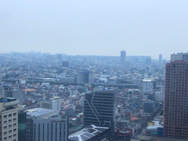 A view of the skyway in the distance
The view of the intersection gave some flashbacks to times when I was a student and a young researcher who had to find good vantage points for collecting traffic data particularly for intersections. Aside from the movements and the corresponding counts, the junction configuration can clearly be seen from the top and useful for developing models for analysis. There was a time when we coveted such views for traffic simulation. You can can install a camera so that you can record hours of footage to use for data extraction. The video recording also allowed one to revisit the footage in case there are questions regarding the data. The same videos can also be used for image processing for more automated, even intelligent or smart data collection using computers.
–
Learning to commute in Singapore
In a recent trip to Singapore, we took advantage of their excellent public transportation system to teach our daughter about commuting using public transport. It will be useful for future travels especially in countries we plan to visit that also have similar transit systems.
 |
| Descending to the subway station near our hotel |
 At the station level, one needs some sense of direction and the layout of the station to know where to get a card or tickets and where to enter the station towards the platforms.
 Station and train information are available and very visible in SMRT stations
 Network maps help one plan a trip including determining where you can transfer from one line to another. While there can be many transfer stations, the key is to determine the least number of stations as presumably this will lead to less travel time. Offhand, a familiarity with stations may also be useful to determine where it is easier to transfer (i.e., same platform for two lines rather than having to walk, ascend or descend to transfer).
 Singapore’s transit system employs ezlink cards for the convenience of commuters. We got one each and its nice that we got these cards with the Doraemon design.
It took only a couple of rides for our daughter to learn how to commute in Singapore. That’s how easy it was and it should be very similar if we’re traveling to Japan or Korea, even Europe at some point. The public transportation in cities in those countries are really good and easy to figure out and use. Hopefully, we can soon take her to learn how to use the LRT in Metro Manila and perhaps also the bus and jeepney. That will be an interesting experience.
–
