
Suvarnabhumi Airport check-in
I forgot to post a few more photos of my recent trip to Bangkok where I was able to explore its large Suvarnabhumi International Airport. I will write more about the airport in installments to describe the airports features in more detail. For this post, the following photos show the entrance, check-in and pre-immigration areas. Taking photos at the immigration areas is not allowed so I didn’t take a chance to take photos there as I might be accosted by authorities.
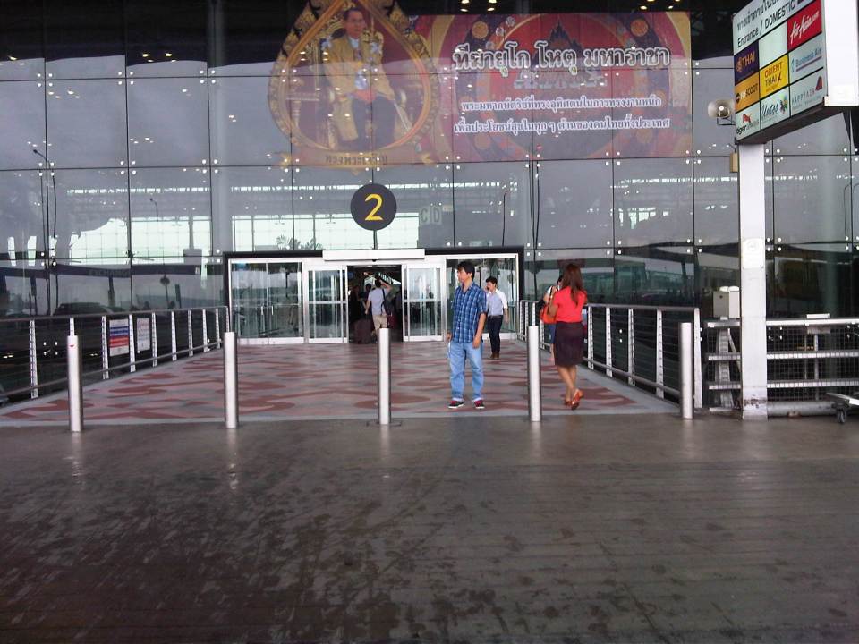 Entrance to the airport from the driveway – we took a taxi from our hotel. There were four of us and some had a little shopping so it wasn’t convenient to take the train to the airport.
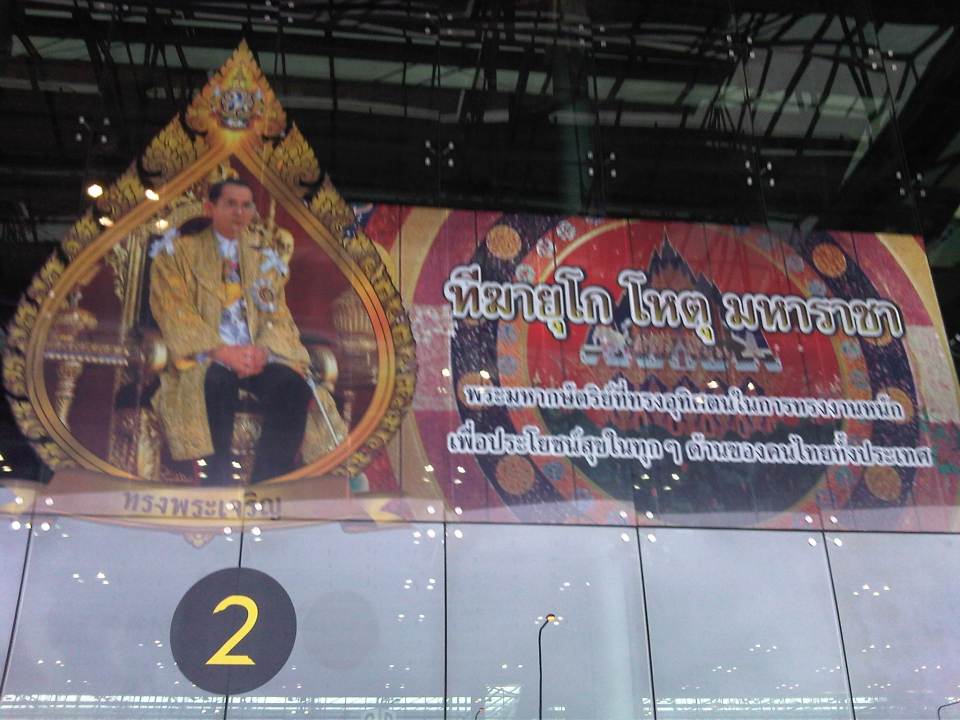 Greetings from His Royal Majesty, the King of Thailand – the Thais are proud and very respectful of their king.
 Check-in counters for the full service airlines – we traveled via Thai Airways, which is currently one of the best airlines in the world.
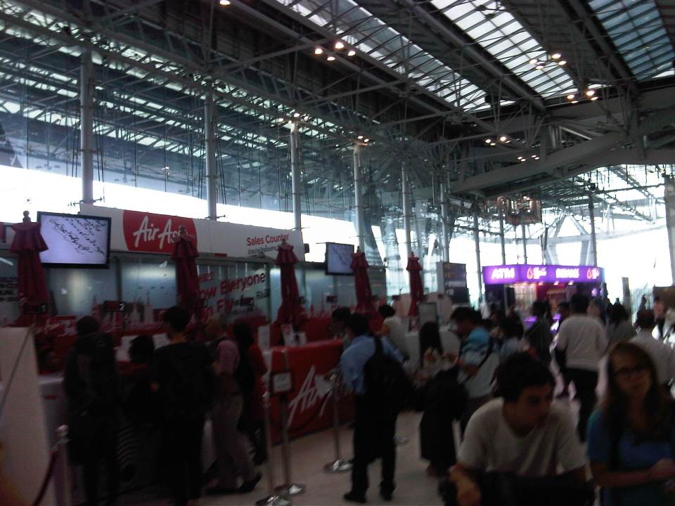 Ticketing counters for budget airlines – I found it quite unusual that the ticketing counters for some budget airlines like AirAsia was along what should have been a wide corridor leading from the entrance to the check-in counters.
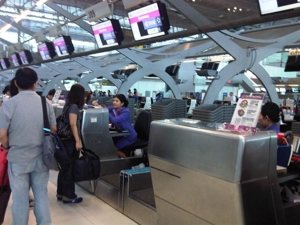 Thai Airways check-in – I had already checked-in prior to arriving at the airport for my return trip, thanks to the online check-in feature of the airline, so I just had to drop off my luggage for tagging. Others who were just checking-in to get their seats and drop off their luggage had to go through the usual procedure.
 Information board for departing passengers provide directions
 After checking-in, people have the option to shop, eat or proceed to immigration to enter the pre-departure area where there are more shops, restaurants and the airline lounges.
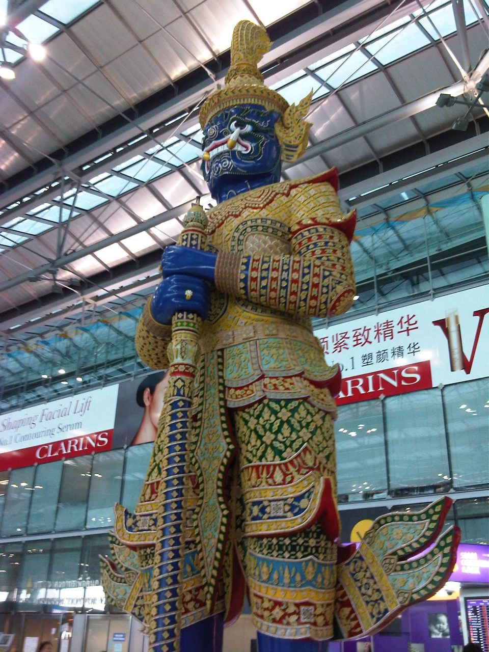 Sentinel? – among the things I like about Suvarnabhumi are the features such as this that define the airport in as far as character is concerned. It is a modern airport and yet they were able to infuse Thai culture wherever its possible. A similar case may be found in Bali and I hope they’re able to retain that airport’s character with their new terminal (under construction when I was in Bali last February 2012).
More on Suvarnabhumi Airport later!
–
New Director of UP’s National Center for Transportation Studies
The National Center for Transportation Studies (NCTS) of the University of the Philippines (UP) has a new head. Dr. Hilario Sean O. Palmiano formally took over the reins of the NCTS from Dr. Jose Regin F. Regidor. Dr. Palmiano is an Assistant Professor of the Institute of Civil Engineering of the UP College of Engineering. He obtained his doctorate and master’s degrees from the Tokyo Institute of Technology (Tokyo Tech) and his baccalaureate degree in Civil Engineering from UP Diliman. His researches are mainly on road safety and non-motorized transport.
 Staff and Fellows of the National Center for Transportation Studies with its new Director, Dr. Sean Palmiano, in the center of the front row. Also in the photo are former Directors, Dr. Ricardo Sigua, Dr. Hussein “Tho” Lidasan and Dr. Regin Regidor. At center of the 2nd row is Dr. Mario Delos Reyes, current Dean of UP’s School of Urban and Regional Planning (SURP).
–
Still know nothing about me
Enjoying the performances at the Sting concert the other night, I couldn’t help but remember the couple of pingbacks this blog recently received from some hecklers (or trolls?) who obviously didn’t understand what I wrote about the AGT currently being tested at the UP Diliman campus. Calling me a “so-called” expert in transport gets my attention but then I’m not the sort of person who’s insecure about my experiences, talents and skills so I’d rather dedicate a song to these fellows. Just a tip… try to read the other articles in the blog to better understand how and why I write about topics on transport and traffic before you make your conclusions about what’s been written.
On pedestrian overpasses again
Pedestrian overpasses in Metro Manila are of various designs. The older ones are mostly concrete structures that were not designed to consider the needs of senior citizens or persons with disabilities (PWDs). Often the stairs are relatively steep and each step can be quite high. More recent ones, particularly those constructed by the MMDA in the last administration were steel structures. The first generation where constructed similarly as their concrete versions, with little consideration to the elderly and the physically-challenged. Many of these overpasses even got flak from women’s groups as the steps featured slits through which women can be taken advantage of by peeping toms. And so some of the “offending” overpasses had their stairs retrofitted to provide some cover for people using these facilities.
A good feature of more recent overpasses constructed has been ramps that allow easier access by persons with disabilities and cyclists. Most new overpasses in Metro Manila also have less steeper stairs and others even have landings to allow people to have some pause while climbing up or down the overpass. Following are a few photos of overpasses along Marcos Highway including one connecting a major shopping mall to the LRT Line 2 Santolan Station.
 Overpass along Marcos Highway in Pasig City featuring a ramp that can also be used by cyclists and persons with disabilities.
 “Conventional” overpass along Marcos Highway – there are no ramps but the stairs are not as steep as the older ones.
 Overpass connecting a major shopping mall to the LRT Line 2 Santolan Station
While such overpasses are necessary along wide roads with heavy motor vehicle traffic, similar facilities are not usually recommended for narrower streets where motorized traffic is manageable. There are discussions now that call for pedestrians to have the right of way along streets. Such discussions have basis given pedestrians attempting to cross at designated areas (definitely not the jaywalkers) have difficulty crossing as motor vehicles disregard them, with some seemingly attempting to sideswipe people (nananadya?). The rule should be that once a pedestrian steps on the pavement at a zebra crossing or crosswalk, vehicles should give way to them. Many drivers and riders are oblivious to this rule and it is not enforced by the MMDA or police. They should, in order to effect behavior change in motorists and to ensure the safety of pedestrians.
–
Better air quality conference
The Better Air Quality 2012 Conference comes back to Hong Kong this year and is an annual event organized by the Clean Air Asia, which was formerly the Clean Air Initiative for Asian Cities (CAI-Asia), attended by government leaders, policymakers, NGOs, the academe, private companies and other stakeholders. It is actually my first time to attend the conference though colleagues have participated in the past. This year I am participating as a transport expert and will be involved in two events – a BAQ pre-event and a session during the conference itself.
The pre-event to be held at the Hotel Nikko is on “Long Term Impacts of Low Emission Transport Policies and Actions in ASEAN” while the session in the conference is on “Transport, Energy and Emissions in 2050: Implications for Asia.” These are related as they are part of the same project implemented and supported by CAI-Asia, the Institution for Transport Policy Studies (ITPS) and the Transport Research Laboratory (TRL). There are five of us from various ASEAN universities including friends from Gadjah Mada University (Indonesia), University of Malaya (Malaysia) and Thammasat University (Thailand). I’m looking forward to a very productive conference and will post again soon about this project that we have been working on since last year.
 Metro Manila smog visible in the background of this photo of our plane to Hong Kong
–
Sound bites on transport and traffic
If there was one thing I both dreaded and enjoyed during my 6-year stint as head of UP’s National Center for Transportation Studies, it is granting interviews to the media. My predecessors warned me about how some media outfits have been notorious for editing interviews to suit their needs. In certain cases, they are alleged to have spliced recordings that if taken as is would have been boring or not quite informative in order to have material that were more sensational. There are features, for example, where it seems interviewees were responding to the each other’s opinions making it look like they were arguing. And then there are those where certain statements are taken out of context when cut from a long explanation in the actual interview that took place.
I think I tried my best to be careful about what I said and how I explained or related things in my interviews. I looked at interviews as a way the Center could reach out and advance its advocacies. These were opportunities to spread the message of sustainable transport, to educate and inform officials and the public about what we should aspire and work hard towards achieving in transport and traffic. I think we had to be both progressive and aggressive with our messages because it was our duty, our responsibility not just to do research and train people but also to inform and educate people about sustainable transport. Popular mass media is an effective way to do this and we should be engaging but careful about our messages in order to be constructive and fair.
The last news interview I had before finally being relieved of being holdover Director for a month after my term ended was with GMA News. I like this interview about traffic congestion because I was able to put in some of the ideas that people in the forefront of sustainable transport have been preaching and practicing. These include the truth that in developed countries and cities, the wealthy take public transportation and that in order to improve public transportation, decision makers should themselves experience commuting.
These are not new ideas and I have to be clear that these were not my original ideas but those that I have come to embrace and advocate. I truly believe that if we don’t take public transportation, walk or cycle, we can’t really have a clear picture of what our cities need in order to solve the traffic mess and come up with services that are safe, efficient, inclusive and equitable.
The feature appearing on Jessica Soho’s State of the Nation on Channel 11 from the GMA News website.
The same report that appeared in the primetime 24 Oras:
–
Special lectures on Traffic Engineering and ITS
The National Center for Transportation Studies hosted a series of lectures by a visiting professor last November 27 and 28, 2012. The lectures were delivered by Dr. Takashi OGUCHI, Professor, Department of Human and Social Systems and the Advanced Mobility Research Center of the Institute of Industrial Science of the University of Tokyo. Dr. Oguchi is currently a Visiting Professor under the Engineering Research and Development for Technology (ERDT) Program of the Department of Science and Technology (DOST) and is hosted by the Institute of Civil Engineering (ICE) of the UP Diliman College of Engineering.
The lecture on Nov. 27 was on Traffic Engineering and was well attended by students, UP staff and guests from government agencies. Dr. Oguchi lectured on the basic concepts of traffic flow theory including bottleneck phenomena.
 Dr. Oguchi talking about traffic congestion
 The NCTS Toyota Training Room was full with participants including students, staff and guests from government agencies.
 Dr. Oguchi explaining about the difference between time mean speed and space mean speed using an illustrated example.
The lecture on Nov. 28 was on Intelligent Transport Systems (ITS)
 Dr. Ric Sigua of the ICE introduces Dr. Oguchi before the latter’s lecture. Like the previous lecture, the venue was full with attendees from UP and government agencies.
 Dr. Oguchi also spoke about the ITS World Congress to be held in Tokyo next year.
 Dr. Oguchi fields a question from Dr. Eric Cruz of the ICE during the open forum right after the lecture.
–
Updates on the UP AGT
The prototype vehicles for the Automated Guideway Transit (AGT) project of the DOST through its PCIEERD and MIRDC were delivered last Sunday, November 25, at the test track site in UP Diliman. The two vehicles will form the train that will be mounted on the test tracks and subject to experiments to test the performance and functionality. Researchers from UP Diliman, including faculty members from its College of Engineering and College of Science, will be cooperating with the DOST to provide advise on issues that are certain to crop up once the tests are underway.
Contrary to many reports coming out that it will be an “upgrade” or “replacement” for the Ikot and Toki jeepneys currently operating inside the campus, the truth is that a Phase 2 creating a loop around the campus is not viable for the foreseeable future. For one, the system will be too expensive to build, operate and maintain for a very limited ridership that is attributed to UP Diliman, even with the increasing numbers of through trips using UP public transportation. Of course, it would be nice to have a system like this in campus but the costs cannot be covered by revenues from fares. Funds for construction (investment costs), seen from one perspective, may be of better use elsewhere where resources are in dire need to support other very important endeavors. A full system would be appropriate elsewhere and with funding coming not from the DOST or UP budgets but from airports, developers, local governments and others who can be the proponents for such systems.
 AGT vehicle delivered at the test site in UP Diliman – the streamlined body was designed by DOST project staff. The skirt helps to hide the bogey, which includes the mechanism for the vehicle to pick up power from rails embedded along the guideway.
 Inside the vehicle – there are few seats behind the driver’s cab to maximize space for (standing) passengers. This layout is very much similar to other AGTs and monorails including those serving airports where users would also have luggage with them.
 Driver’s cab – although the intention is for the vehicle to be ultimately driverless, tests will initially be conducted with a driver.
 Back seats – there are a few more seats at the back but the layout maximizes the number of standing passengers.
 Another look at the AGT vehicle – the DOST logo is prominent in the front and one side of the vehicle. The UP logo is on the other side of the vehicle.
 Test tracks – the AGT guideway is elevated and stretches to almost 500 meters. For reference, the photo was taken from near the project office/power house with the CHED building along C.P. Garcia Ave visible downstream of the elevated guideway. The line of trees on the right is along the University Avenue.
While it is understandable that certain rail aficionados have become excited about the prospects of having an operational, functional AGT or monorail, the UP-AGT is really an experimental system. It is best considered as a “proof of concept” project that will hopefully encourage the development and promotion of public transport in many of our cities that seem to be mired in having unsustainable transport modes. But of course, any transit system such as this will not survive if no rationalization in transport services are implemented and this is particularly true if an AGT or monorail would have to compete directly with buses, jeepneys or tricycles.
–
On runway configuration and orientation
We teach our students the basics of Airport Engineering including design principles for airside and landside facilities. The most important airside facility is the runway and there are several factors affecting the determination of runway configuration and orientation. Even for single runways, these factors are critical in order to ensure safe and efficient operations. Factors affecting runway configuration and orientation include:
1) Wind – the direction and magnitude of the wind is critical for aircraft as headwinds help generate the lift required for taking-off and cushioning landings. Headwinds will tend to shorten runway length requirements due to this assistance with lift while tailwinds will tend to increase runway length requirements. Cross winds are undesirable as they may cause aircraft to roll or stall. A useful tool for establishing wind behavior (e.g., directions and speeds) is a wind rose, which requires many years of data on wind speeds along different directions to establish the best orientation for a runway. The wind rose pretty much looks like a spider graph overlaid unto a compass, illustrating along which directions the winds are strongest. Wind roses may also be constructed according to the times of the year to account for seasonality in the information.
2) Neighboring airports and airways – one can just imagine the nightmarish situations faced daily by air traffic controllers in New York where there are several major airports not just in that city but in nearby metropolitan areas as well such as New Jersey, Philadelphia and Washington, D.C. where hundreds of flights converge in what is very limited airspace. Thus, air traffic controllers would have to be mindful of the shared air space among planes operating out of the different airports in providing guidance to pilots taking off or maneuvering for a landing.
3) Obstructions – these refer to possible obstructions around the airport and particularly along the flight paths of aircraft and imaginary surfaces are drawn with respect to the proposed runway configuration to determine the height restrictions for structures and other features around the airport. These imaginary surfaces include the projection of aircraft approaches from either end of a runway (or runways) that logically should be free from any obstructions. Cities are required to strictly enforce land use regulations around an airport to ensure safety.
4) Topography – the presence of mountains or bodies of water will influence how an airport will be laid out including considerations for future development or expansion. In many cases, mountains will influence other factors such as wind and obstructions. In certain areas, airports are built over plateaus, thereby restricting development options from the start. Examples of these in the Philippines are Baguio’s and Cagayan De Oro’s airports that are also affected by fog, adding to the challenges (and hazards) faced by pilots.
5) Restricted areas – there are certain “no fly” zones in cities such as the airspace directly above sensitive areas or buildings like military camps or the official residences of heads of state/government (e.g., Malacanang, the White House, etc.) are enforced as a matter of security.
6) Bird hazards – there have been an increasing incidence of bird strikes reported in the local news with many attributed to the increase in numbers of migratory birds. These pose hazards to aircraft (even the large jetliners) as the birds can get sucked by their engines resulting to damage to the propellers or fan jets. As such, many airports employ staff to ward off birds or use devices to disperse them. These efforts, however, are limited to the airport grounds. Beyond the airport, birds, particularly those in protected areas may still pose dangers to aircraft should the areas be along the aircraft flight paths.
7) Control tower visibility – air traffic control provides guidance for aircraft operations whether they be on the ground or in the air. While there are modern, hi-tech instruments available in most large or major airports, safety and guidance is greatly enhanced with the tower visibility to pilots (and vice versa).
8) Jet blast and wing tip vortices – aircraft take-offs and landings are regulated not just in terms of who has priority over the other (e.g., landing aircraft typically have the “right of way” over those waiting to take off) but also to give some headway in order to allow for the dissipation of turbulence generated by aircraft operations. This may be especially important in cases where there are multiple runways including intersecting configurations where aircraft may cross flight paths.
9) Runway length – the required length of runway may be dependent on the types or models of aircraft that intend to use it. Larger aircraft will require longer runways with the Boeing 747s requiring about 2 kilometers for take-offs under various conditions. Smaller aircraft, of course, will require shorter runways and typical airstrips for 2-seater or 4-seater aircraft can be less than a kilometer long.
10) Environmental factors – aircraft operations inevitably lead to pollution including the emissions and noise they generate. As such, land uses around airports should be planned accordingly in order to reduce issues pertaining to noise and air quality. Unfortunately, land use regulation in Philippine cities are not strictly enforced and so there will always be developments that are incompatible with airports with ironies when communities developed after the airport complain of noise and air pollution.
–
Carbon footprint accounting tool development
The French Development Agency (AFD) is supporting the capacity and capability building for Greenhouse Gas accounting for transport projects in the Philippines through a project connected with the current initiatives on Bus Rapid Transit (BRT). Part of their engagement is the development of a tool for assessing carbon footprints of transport projects that can easily be used by officials and staff involved in evaluation work. Consultation seminars were conducted last July with various agencies and particularly the Department of Transportation and Communications (DOTC). And technology transfer is being undertaken through the National Center for Transportation Studies of the University of the Philippines Diliman, which will also be tasked with sharing the knowledge and providing training for the use of the tool for other users as well. A series of trainings were recently conducted by the consultant, Carbone 4, a Paris-based firm that was engaged by AFD for the project.
 Julien Blanc of Carbone 4, the firm appointed by AFD to develop the GHG accounting tool, explains the features of the software.
 NCTS Fellows, staff and graduate students participated in Day 1 of the training. Days 2 and 3 involved participants from various government agencies invited for the 1 day training.
 Everyone was required to have a computer to have hands-on experience on using the tool with exercises provided by Julien.
 In certain cases, Julien had to help out when some features did not work on some of the computers or when some participants had different results from what was expected from the exercises.
 The tool is MS Excel-based and employs macros for calculations and to produce the graphs illustrating outputs such as fuel efficiency profiles for vehicles.
The tool is not yet completed as there are still features to be included but it is already a working version that allowed us to input values and manipulate the tool for familiarity. The tool was developed using MS Excel and employs macros for calculations and the production of graphs to illustrate outputs such as comparative fuel efficiency profiles for vehicles having different engines. The tool should be compatible with computers running the Windows or OS-X (Mac) systems.
–
