
On bike lanes network development – examples in the US
I am sharing this article on the best new bike lanes in the United States:
Haggerty, M. (January 12, 2024) “The Best New U.S. Bike Lanes of 2023,” People for Bikes, https://www.peopleforbikes.org/news/the-best-new-u.s.-bike-lanes-of-2023 [Last accessed: 1/23/2024]
Quoting from the article:
“Even for the most ardent naysayers, it’s difficult to deny that the landscape of bicycling in America is transforming (although not as quickly as many of us would like to see). While we have yet to see any U.S. cities emerge with truly bold citywide plans for bike networks as we’ve seen in places like London, Paris, and Bogota, many are (slowly) beginning to envision a future where cycling takes center stage. Although there remains a substantial amount of work ahead of us to cultivate a safe and comfortable environment for people of all ages and abilities to ride bikes in the U.S., it’s well worth pausing to commemorate the significant infrastructure victories U.S. cities achieved in 2023.”
The quote above also applies to us in the Philippines where there are still few examples of safe and comfortable bike lanes. I shared the same article on my social media page asking aloud if there’s something like this in the Philippines. I am aware of the Mobility Awards but that’s supposed to cover everything on mobility and particularly walking and cycling. The list is about bike lanes and touches on the various designs (note that in the US, while there are federal guidelines, most if not all states and cities would have their own that they use for planning and design of bicycle facilities). It would be nice to have our cities develop guidelines while also referring to the minimum standards in the DPWH Guidelines. Of course, the challenge is to come up with good if not the best designs and not just comply with the minimum.
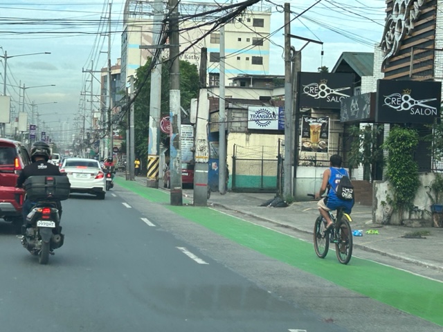
 If there was an award for best new bike lanes in 2023, I think Quezon City will have several nominees and even win the award with one. Picture above is the bike lane along Katipunan Avenue/C5.
–
Speed limits and danger zones for trucks
Saw these signs at the back of a long truck as we were stopped before an intersection. One states the speed limits for these vehicles along different roads while the other is a warning sign for other road users especially those who might be less visible when the truck maneuvers (e.g., motorcycle riders, cyclists).
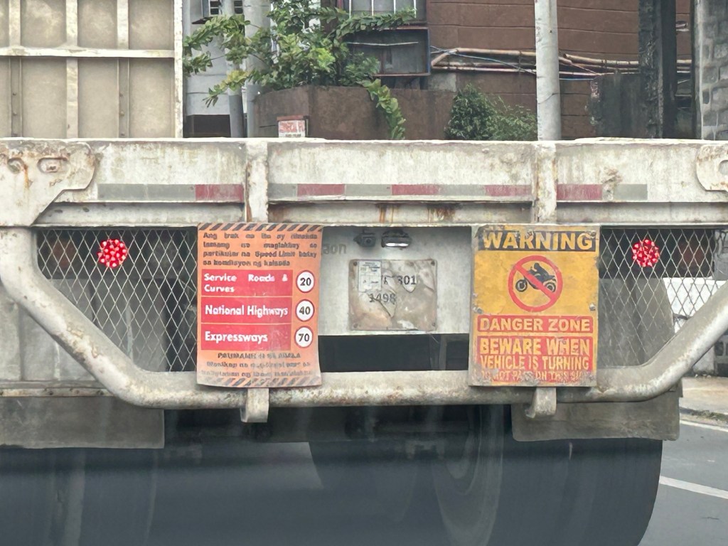
These are important information and fair warning to other road users. However, I think the signs should be bigger to be more visible or conspicuous. You have to be close to the truck for one to read and understand what the signs were. It might be too late by the time one figures out what the warning was about. I’ve read somewhere about people trying to debunk or play down these danger zones for trucks. That is bad opinion and puts drivers and riders heeding it in harm’s way. I think we should always go for what is on the safe side rather than risk being hit by these trucks.
Such information should be part of driver and rider education and perhaps education in general. While these large vehicles pose risks to other road users, they also play an important role particularly for logistics.
–
Solar road studs for Ortigas Avenue Extension bike lanes
The bike lanes along Ortigas Avenue Extension now have solar road studs for these to be more visible at night time or when it is dark. Following are photos of the bike lanes at night.
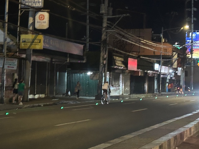

While the studs enhance the visibility of the bike lanes and perhaps also the safety of cyclists, the latter is not assured. The bike lanes are not protected and physical barriers like those installed along Quezon City roads are most effective in ensuring the safety of cyclists against motor vehicles. The solar studs do not deter motor vehicle drivers from encroaching on the bike lanes so they appear to have minimal impacts on safety.
–
Westbound bike lane along Ortigas Avenue Extension, Cainta, Rizal
I was not able to post these photos of the westbound bike lane along Ortigas Avenue Extension immediately after I shared photos of the eastbound bike lane. The bike lanes, as can be seen from the photos, are painted green.
 Bike lane past Valley Golf and STI
 Bike lane approaching Brookside (Sunset Drive) with the CK Square as a landmark
 Still a big issue for bike lanes is the presence of electric and communication poles/posts that have not been relocated after so many years since Ortigas Avenue had been widened.
 Bike lane across from Tapsi ni Vivian
 These photos were taken before the solar studs were installed to delineate the bike lanes and make them more visible at night or when its dark.
 Also, challenges and concerns for cyclists are parked vehicles and those maneuvering from the various establishments along the road. This photo pretty much captures those two concerns – a parked UV Express van and a truck maneuvering out of a store occupying the bike lane.
 Cyclist pedaling along the bike lane approaching the Shell Gas Station (where there is also a McDonald’s)
 Bike lane in front of the Ortigas Hospital just outside the Brookside Gate 1 and near Cainta Junction
More photos of the bike lanes soon!
–
On recent airline incidents in Japan and the US
There were two recent incidents involving airlines the past days. One was on a collision as a Japan Airlines Airbus A350-900 jet arrived at Haneda Airport in Tokyo. The other was a midair incident where an Alaskan Airlines Boeing 737 Max 9 plane lost part of its fuselage. While both are troubling, the first incident provided a good example of how emergency evacuations should be. The second incident reminds us of the importance of aircraft maintenance and tests to make sure planes are safe for use by passengers.
To quote from a New York Times article on the Haneda Airport incident:
“In addition to a well-trained crew and an advanced plane, the safe evacuation of 367 passengers came down to a relative absence of panic.”
I think that basically described “how to survive a plane crash” in the context of the collision at the airport, where passengers and crew had to evacuate the plane immediately.
Meanwhile, the B737 Max crash is a cause of concern since the model was already involved in previous crashes that caused the planes to be grounded worldwide. There will be an investigation on this incident and perhaps the outcomes can help address the problems concerning the aircraft. On the business side, such incidents will further convince airliners to reconsider acquisition and operations of these planes. I am sure they are already thinking about replacing the B737’s with the competition’s aircraft (e.g., A319, A320 or A321).
–
Article share: on making roads greener
I came upon this article on ‘greening’ roads:
Goldfarb, G. (December 23, 2023) “This Radical Plan to Make Roads Greener Actually Works,” Wired, https://www.wired.com/story/this-radical-plan-to-make-roads-greener-actually-works/?bxid=5bd6761b3f92a41245dde413&cndid=37243643&esrc=AUTO_OTHER&source=Email_0_EDT_WIR_NEWSLETTER_0_DAILY_ZZ&utm_brand=wired&utm_campaign=aud-dev&utm_content=WIR_Daily_010324&utm_mailing=WIR_Daily_010324&utm_medium=email&utm_source=nl&utm_term=P8 [Last accessed: 1/4/2024]
To quote from the article:
“The very notion that a road can be “green” seems oxymoronic: A vast body of scientific literature demonstrates that roads befoul air and water, fragment ecosystems, introduce non-native species, and obliterate wildlife.”
That was a pretty damning or severe statement about roads considering such infrastructure are necessities in today’s world. Perhaps we should revisit road planning and design to address these issues referred to. Aside from that quote, the article related a number of good examples worth replicating. In fact, I recall that many Philippine roads were envisioned, even designed, to have greenery along them. The tragedy is when the DPWH and LGUs departed or deviated from these plans. The road widening projects of the past years are examples on how national and local agencies have proven the article’s author right about green roads being oxymoronic.
–
Lagusnilad now
The underpass across from the Manila City Hall is called Lagusnilad. The underpass is prone to flooding and had been neglected for a long time under several administrations spanning several Presidents, DPWH Secretaries and Manila Mayors. Kudos to the recent Mayor and DPWH officials who finally addressed the flooding problem as well as improved the pavement and lighting for Lagusnilad.
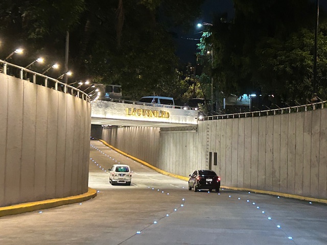 Approach to the lowest point of the underpass from Padre Burgos Avenue, one notes the now well-lit underpass and the solar studs marking the lanes.
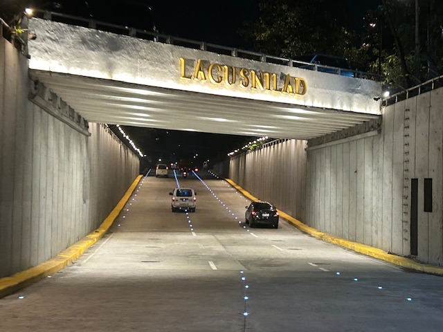 The lowest section of the underpass is prone to flooding but major rehab works to the drainage plus new pumps appear to have addressed the problem.
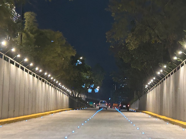 Emerging from the underpass towards Taft Avenue
I have memories of when this underpass was often flooded back in the 1990s including a time when vehicles braved the waters and got stuck after drivers discovered just how deep the waters can be. The joke then was that the underpass would be renamed ‘Langoynilad’, alluding to people and vehicles having to swim to traverse this section.
There is also a pedestrian underpass that is called Lagusnilad. This connects City Hall with Intramuros and used to be so dirty and stinky. Again, credit is due to recent officials who rehabilitated the underpass to what is now a tourist attraction but more importantly a good practice example for pedestrian facilities.
–
On road crashes involving trucks
In the week leading to the Christmas break, there was a major crash in Antipolo City along Ortigas Avenue Extension. The crash caused a standstill for both inbound and outbound traffic as the road was impassable to traffic and later, only one lane was available and vehicles had to take turns to use the lane. Here is a photo taken by a passer-by and shared multiple times on social media:

The crash damaged electric and phone poles causing power outage and phone and internet lines to be disconnected. Obviously, the crash not only inconveniences travelers but a lot of residents of the area affected by the blackout and phone and internet disruptions. Crashes like this are preventable if only operators and drivers are extra diligent with vehicle inspection and maintenance. Apparently, the occurrence of such crashes are not enough a lesson that people could learn from. So there needs to be stronger initiatives including inspections of vehicles that can cause major damage and murder. While we expect a lot from national government, local government units must also pitch in along with the private sector in order to improve safety conditions.
We hope that 2024 will be better and that we will have safer roads for all users.
–
Happy New Year and Safer roads for 2024!
We conclude 2023 and begin 2024 with hopeful greetings for everyone especially for the coming year!
Last December 18, 2023, an event was held in Quezon City for the launch of the Global Status Report on Road Safety 2023 by the World Health Organization (WHO) and the signing of a Memorandum of Understanding for Child Road Traffic Injury Prevention (CRTIP) by the UN Children’s Fund (UNICEF). Advocates of road safety were gathered for the launch and the MOU signing including top officials of the Department of Transportation, which is the lead agency for the initiative.

 Information and links to the WHO Road Safety Data app. The app is available on Google Play and the Apple App Store. You can also scan the QR code in the photo to get the app and install it on your gadget.
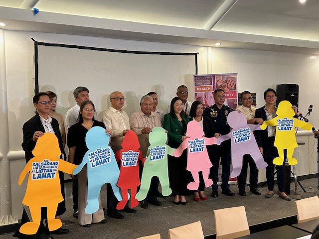 Representatives of the various agencies, offices and groups who signed the MOU for the National Coalition for Child Road Traffic Injury Prevention (NC-CRTIP).
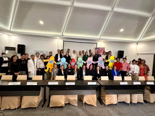 Participants to the MOU signing and Philippine launch of the WHO’s Global Status Report on Road Safety 2023
I learned there that the DOTr intends to reconstitute an inter agency committee on road safety. This is a throwback to the Road Safety Steering Committee and Technical Working Group during the time of then President Gloria Macapagal-Arroyo and then DOTC Secretary Leandro Mendoza that was co-chaired by the DOTC and DPWH. People were able to discuss road safety along various contexts and formulate programs and projects involving many if not most of the agencies and organizations at the time. These same agencies and organizations plus many others are still actively campaigning for safer roads or safer streets. Unfortunately, many are not talking with each other and there are those who seem to assume that there were no effort before to make transportation safer (sorry not sorry for pointing that out quite bluntly here). I am hopeful that this committee will be reconstituted this 2024 and that will lead to safer roads for everyone.
–
Congestion near bus terminals during the Christmas season
I attended a formal event yesterday at the Philippine International Convention Center (PICC) in Pasay City. Along the way and back, I already noticed the congestion along Gil Puyat Avenue (formerly Buendia Avenue) as well as the congestion or how crowded the bus passenger terminals were. In fact, the buses at the JAC Liner terminal along Gil Puyat were all on the streets. The terminal itself was filled with passengers, many of whom were queued as they waited to board their buses. Others I assumed were in line to purchase tickets there. The latter apparently have not done so online, which is already an available and more convenient option for provincial travel.
 |
| Buses lined along the Makati-bound side of Gil Puyat Avenue. These are queued towards to the U-turn slot that will take them to the bus terminals on the other side and near Taft Avenue. |
 |
| Other buses are lined along the Pasay-bound side of Gil Puyat Avenue. These come from the South Superhighway where these buses eventually head to after boarding passengers en route to Southern Luzon, Bicol and even Visayas and Mindanao destinations. |
Then as now, the junction of Gil Puyat and Taft Avenues is a major convergence area for transportation especially provincial routes. Even before the construction of the LRT Line 1 (which has a station at Gil Puyat) there have been a number of bus terminals here. Currently, I am aware of the JAC Liner and DLTB bus terminal near the junction. There are others including small terminals or garages for provincial buses. These generate much traffic particularly during this Christmas, which is considered peak season for travel in the country.
–
