
On walking and running for health
Here is a quick share of an article on walking and running from the New York Times:
Why College Campuses Make Ideal Models for Cities
I recently read this article on college campuses being models for cities. Of course, this refers to campuses or perhaps university towns that have developed in the US. These appear to be microcosms of cities or what cities should be. I can imagine this for the UP Diliman and UP Los Banos campuses. There are others that are similarly structured but most universities and colleges in the Philippines may not even have full campuses like UP including those in the University Belt in Manila. Many are practically just buildings. Others that have land like UST and Ateneo do not have the residential areas like UP’s that would make the campus a town in itself.
To quote from the article:
“Universities and other educational institutions make the lives of their students easier by placing amenities close to student housing so they can travel on foot or by bicycle to reach their destinations. This design encourages human interaction and improves quality of life.
The same can be done for cities and towns. Urban planners can look to college campuses for inspiration, borrow the features that enable this lifestyle, and incorporate them into city design. Such a holistic approach will make it preferable to travel on foot, make sustainable transport more accessible, and create thriving local economies.”
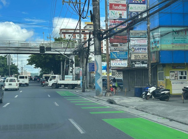
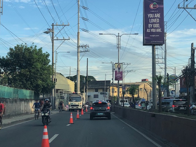
Eastbound bike lane along Ortigas Avenue Extension, Cainta, Rizal
I recently posted about the newly painted bike lanes along Ortigas Avenue Extension between Cainta Junction and Valley Golf in Cainta, Rizal. Here are more photos of the bike lanes along the eastbound direction of the avenue.
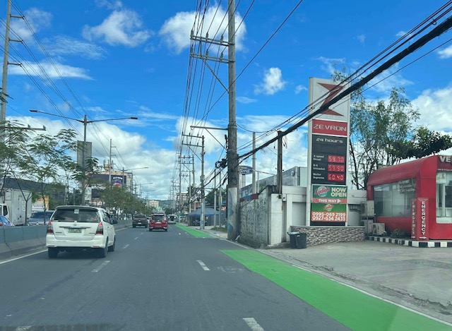 Just past Cainta Junction and across from a gas station. The bike lane marking here though should have been for a driveway due to the service station.
 Bike lane approaching the Ford dealership
 Bike lane in front of the Ford dealership along Ortigas Ave. Ext.
 An unusual discontinuity in front of a vacant lot
 Another discontinuity
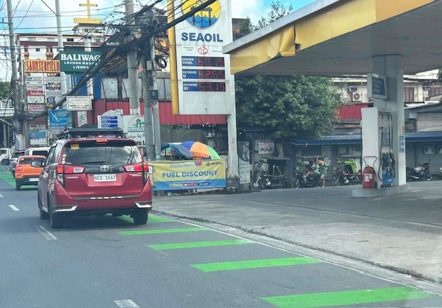 The broken lane markings are supposed to be for driveways and approaches to intersections like this section at a gas station. This was the appropriate marking for the station in the first photo.
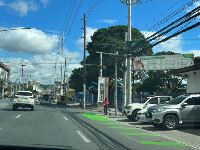
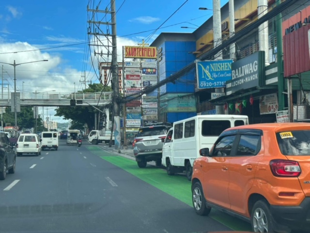 Car parking are a concern for cyclists as they often encroach on the bike lane.
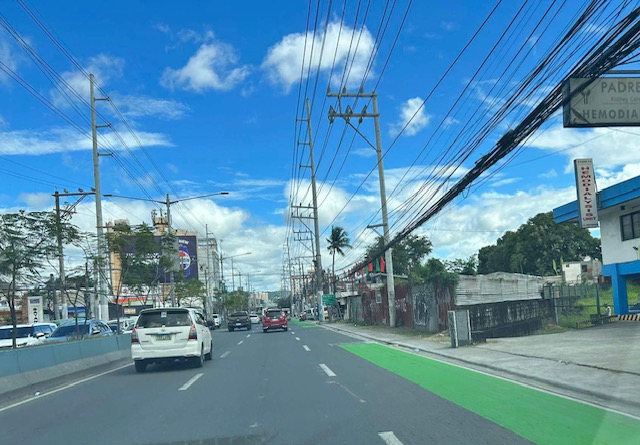
 Approach to an intersection (J.G. Garcia Street) across from Brookside Subdivision gate
 Approach to intersection with Huners ROTC Street and just before STI.
I will share photos on the westbound bike lane along the same section in the next post.
–
Bike lanes along Ortigas Avenue Extension, Cainta, Rizal
The bike lanes along Ortigas Avenue end at the border of Pasig City and Cainta (or Metro Manila and the Province of Rizal). This is just after SM East Ortigas if you are eastbound, headed towards Cainta Junction. Last Friday, I was able to take a photo of the newly painted bike lane along Ortigas Avenue Extension’s eastbound side but which starts just after Cainta Junction across from the main gate of Brookside Hills Subdivision.
 The new bike lane along Ortigas Avenue Extension used luminous paint, which makes it glow at night especially when exposed to vehicle headlights.
There have been bike lanes in Rizal prior to this development. Marcos Highway and Sumulong Highway have painted bike lanes. The Manila East Road from Tikling Junction also has bike lanes. This ‘missing link’ between the boundary of NCR and Rizal and Tikling is long overdue. Hopefully, this will encourage more active transport users particularly from “bike to work” and “bike to school” trips.
–
On walking and taking the stairs
With the increasing popularity of active transport, people still forget that biking is not the only mode being referred to by the term. Walking is the most basic form of transport for us and there are many creative ways to encourage walking even if it is indoors like in an office building, a school building or a shopping mall. Here is a photo of the stairs at one mall with encouraging words for those taking the stairs instead of the escalators or elevators. It only takes 30 minutes of walking everyday to gain the benefits of a more active lifestyle.

My daily walks take me up and down the hilly roads in our neighborhood. I attribute to these walks my relatively effortless climbs to the 4th floor of our school building where my office is. Our elevator has been out of commission for some time now so we are all forced to take the stairs to our lecture rooms and offices. These I refer to as ‘stairmaster’ exercises, which is included in my daily routine so it adds to my step count as well as being recorded for the flights of stairs I take each day. I attest to this routine to improving my health and well-being, and highly recommend this to those who are able to do so.
–
Counterflow lane to Cainta Junction along Felix Avenue
Counterflow traffic schemes seem to be in these days. Cainta used the scheme temporarily while one lane of Felix Avenue was blocked due to the maintenance work being conducted by Manila Water. Following are photos showing the traffic advisory and photos during the counterflow.
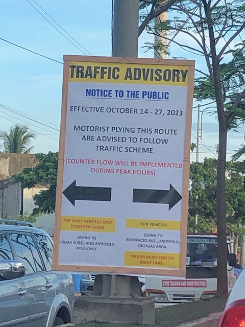 Traffic advisory showing the period when the counterflow traffic scheme was implemented.
 There was a median opening across from a factory’s main gate that allowed vehicles to counterflow.
 The counterflow lane allowed vehicles to bypass the utilities maintenance works being performed by Manila Water’s contractor that blocked the median side lane of Felix Avenue.
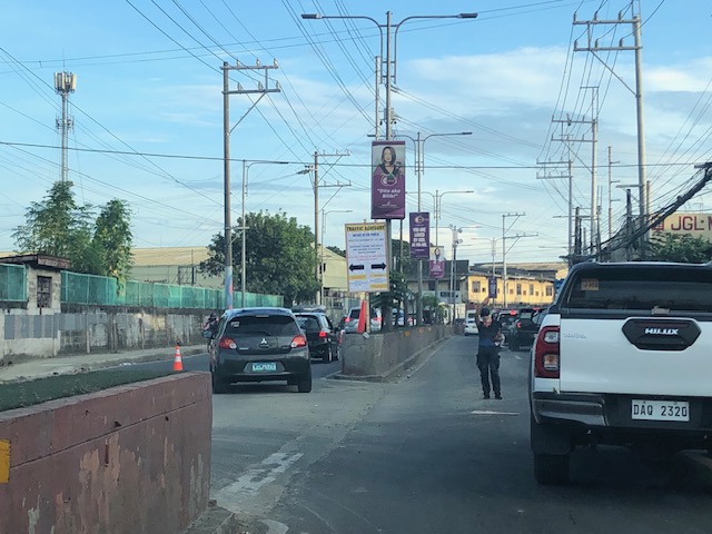
 Approach to Cainta Junction
 The counterflow ends at Cainta Junction where left turning vehicles are positioned correctly for the movement. Through traffic were expected to occupy the other/normal approach lanes.
As the Manila Water concluded its maintenance work, the counterflow scheme was already lifted and traffic is back to normal.
–
Article share: Drought and the Panama Canal
Here’s a quick share of an article on how a drought is affecting operations of the Panama Canal:
Eavis, P. (November 1, 2023) “Drought Saps the Panama Canal, Disrupting Global Trade,” Wired, https://www.nytimes.com/2023/11/01/business/economy/panama-canal-drought-shipping.html?unlocked_article_code=1.7kw.9CNJ.NKhQS8RCMh9h&smid=url-share [Last accessed: 11/3/2023]
From the article:
“But a drought has left the canal without enough water, which is used to raise and lower ships, forcing officials to slash the number of vessels they allow through. That has created expensive headaches for shipping companies and raised difficult questions about water use in Panama. The passage of one ship is estimated to consume as much water as half a million Panamanians use in one day…
Without a new water source, the canal could lose significant amounts of business. Other ocean routes are, of course, longer and more expensive, but they are less likely to have unpredictable delays. One alternative is to transport goods between Asia and United States through the Suez Canal to the East Coast and Gulf Coast. Another is to ship goods from Asia to the West Coast ports — and then transport them overland by train or truck…”
I suddenly remembered the current work along the Marikina River. The government is supposed to be working towards making the river navigable for the Pasig River Ferry to extend operations there. However, the depth of the river prevents regular, reliable operations. I wonder if the current project that includes flood control, riverside roads and erosion control components also will lead to a navigable depth for the river for most if not the whole year.
–
On Undas traffic 2023
The past two years, I have not written about the traffic situation or conditions during Undas or the holidays corresponding to All Saints and All Souls Days (November 1 and 2). There wasn’t much to write about really. The usual traffic congestion would be along roads near cemeteries and memorial parks. Marikina City’s Barangka area and Bonifacio Avenue near Loyola Memorial are usually congested due to the city’s public cemetery and the memorial park combining for significant traffic generation during Undas. The days leading to Undas find people traveling, usually back to their hometowns but these days many go out for vacations instead. And so the roads near the airports, seaports and bus terminals are also congested. Tollways and national roads (especially the main corridors) can also be congested with the exodus of people from Metro Manila to the provinces in Luzon Island. I assume something similar occurs for other major cities as well.
Many people I know seem to be vacationing this week as they took advantage of the October 30 Barangay elections and the declaration of November 2 as a holiday to take the week off. Many probably took leaves for the two days that were not declared as holidays – October 31 (Tuesday) and November 3 (Friday). Many if not most schools I know declared a break for the week. It is, after all, an opportunity for students, teachers and school staff to take a breather. At UP though, this week came shortly after its Reading Break so its likely people were not able to gain momentum despite the opportunity to catch up on matters like assignments and correcting exams or papers.
I saw some social media posts early this week about expressways being congested. A few even opined that tollways were a scam because of the toll fees being collected despite congestion. I found those quite amusing as the alternative would have been national and local roads that would also be congested. Tollways have been proven to provide shorter travel times (and therefore higher level and quality of service) compared to the free roads. Also, its a free country so those who have their own vehicles may choose to take free roads. We also have apps like Waze to help us find alternative routes other than those that involve tollways. But for long distance travel (e.g., Manila to Baguio, Manila to Legazpi, etc.), tollways will always have the advantage over free roads. Of course, the timing of the travel also matters and the long Undas week should allow for some flexibility in travel especially those taking the road trips.
Here’s to a meaningful and reenergizing Undas!
–
Bike racks at SM City Taytay
I have written before about the bike facilities at SM malls. Their new malls and expansion projects already have provisions for bike parking in addition to motorcycle parking despite the building code not having provisions for these. I write about another example, this time in Rizal province. SM City Taytay has bike racks installed at the basement parking. I am sharing the following photos for reference.
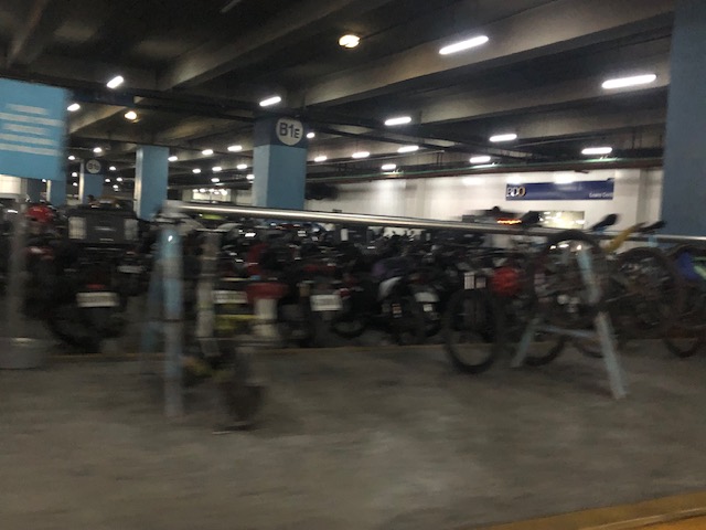 Hand rail/hanger type racks
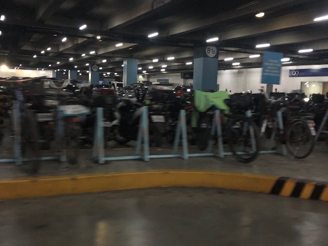 Bollard style racks
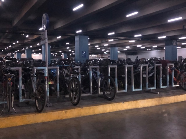 Grid style racks
I’m not sure what went into the decision, if there was any, to provide different types or styles of racks for bicycle parking. To some, it looks like an afterthought rather than a planned approach to bike parking. Still, the facilities appeared to be highly utilized so that means people are taking their bikes to the the mall and it appears that most of these are customers rather than mall personnel. SM has been quite vocal and active in promoting their involvement in active transport (i.e., mostly about cycling) and their malls have included bike parking as an integral part of their facilities. Hopefully, they will continue to support cycling and develop better facilities to encourage bike use.
–
On vehicle maintenance
We own 2 vehicles – one 11 year-old and another that is 7 years old. Both are well maintained but the older one recently required repairs including replacement of its shock absorbers. Recently, we had some trouble on its air-conditioning and eventually had it checked and repaired (defective evaporator).
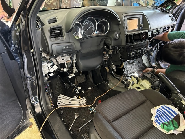 We had our vehicle serviced at home. The shop sent their service people to work on the vehicle at our garage. Here’s what the dashboard looked like while they were working.
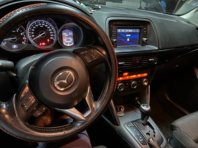 Here is what it looked like after the repairs. The air-conditioning is back strong and smelling all clean.
I joked about all the parts, screws and all, that came out when they disassembled the dashboard. I was worried they won’t be able to remember where to put these back. Of course they were able to assemble them all back and the car and the air-conditioning are all running well now. Vehicle maintenance costs are notable expenses and if you don’t do the routine maintenance works on your vehicle, you might just be surprised at how expensive it would be for major repairs. So far, we have been lucky with our vehicles after the losses due to Typhoon Ondoy (Ketsana) that resulted in 2 damaged vehicles. Maintenance costs are considered by some as hidden costs in owning vehicles. This shouldn’t be the case if you have a regular maintenance regime and keep track of the actual costs.
With the new hybrid and electric models coming out, who knows when the conventional vehicles will be phased out. Those new models would be different in terms of maintenance costs as well. I guess we’ll know soon how much it will take to maintain these new vehicles.
–
