
Another look at the refurbished Mactan Cebu International Airport Terminal 1 – Part 1
We were recently in Cebu City and I just had to take some new photos; this time to feature Terminal 1 of Mactan Cebu International Airport. Here are some photos taken at the departure area.
 Entrance towards the check-in counters. There is no security machine here and but there is a routine check of travel documents of passengers. There are weighing scales for luggage so passengers can check if they are over their limits and still have an opportunity (and the space) to reconfigure.
 PAL’s check-in counters at MCIA Terminal 1
 PAL also now has online check-in machines at the airport. Previously, only Cebu Pacific had these machines. There is only one though unlike Ceb Pac’s multiple machines.
 Check-in counters for Air Asia Philippines
 Travel tax counter at the terminal
 A view of the terminal lobby from the corridor leading to our gate at the other end of Terminal 1.
 Final security check before the pre-departure areas. MCIA now uses modern scanners for screening both bags and passengers. Shoes and belts are among the items they require you to remove from yourself. They also ask you to remove notebook computers to place them on your tray that goes through the machines. You may not remove your watch from your wrist.
More photos in Part 2 coming soon!
–
Another look at home location choices
I recently shared an article showing the results of a survey conducted in the US. That survey appears to show that Americans prefer sprawl. But that may be due to many factors including political leanings that are actually mentioned in the article. I share another article that appears to be a reaction to the first one.
Lewyn, M. (August 14, 2023) “Do Americans Really Prefer Sprawl?” Planetizen, https://www.planetizen.com/blogs/125112-do-americans-really-prefer-sprawl?utm_source=newswire&utm_medium=email&utm_campaign=news-08142023&mc_cid=cd3b2e2ba5&mc_eid=9ccfe464b1 [Last accessed: 8/16/2023]
To quote from the article:
“Why do these surveys yield such drastically different results? The Pew survey notes that 3/4 of rural respondents favor the less walkable alternative; thus, that survey was apparently designed to include a representative sample of Americans, including rural Americans who typically do live in very spread-out environments. It seems to me quite natural that rural Americans would prefer rural lifestyles.
But once rural respondents are excluded, the balance between sprawl and walkable communities in the Pew survey becomes almost a toss-up. 57 percent of urban respondents refer houses with smaller yards and more walkability, and an almost-equal percentage of suburban respondents prefer the opposite.”
Again, I wonder what would be the outcomes if a similar survey were done in the Philippines. Will it reveal preferences for single detached homes rather than condos? Who will prefer the latter or the former? What could be the factors affecting home location choices in the Philippines? Cost is definitely a major factor. Commuting times perhaps and even commuting costs? But how do people weigh these factors? And what other influences are there to the decisions to purchase homes?
–
Changes in NAIA Terminal 2
We recently traveled via NAIA’s Terminal 2. T2 used to be for Philippine Airlines (PAL) only but recently Air Asia’s domestic flights have been reassigned to use T2 as well. Another airline, Royal Air, also now uses T2 for its domestic flights. Meanwhile, PAL’s international flights now use Terminal 1. Only recently did I notice that PAL now has the north wing of T2 for its domestic flights while Air Asia and Royal Air use the south wing. Previously, PAL’s international flights were on the north wing and domestic flights were at the south wing. Gone are immigration counters though customs equipment and still at the north wing arrival area near the baggage claim carousels.
 The Terminal 2 North Wing was previously for PAL international flights only.
 The north wing does not serve all of PAL’s domestic flights so it does not appear to be congested. Only flights to the major domestic destinations go through here such as those between Manila and Cebu, Davao, Iloilo, Bacolod or Cagayan De Oro. I seem to have heard a boarding call for PAL’s Caticlan bound flights at T2, too.
 The Duty Free Shops are still here but charge tax for those not qualified for duty free purchases.
 There’s a Cafe France at the north wing. There are no other familiar brand cafe choices there.
 Antigen self test vending machine at the terminal
 At the south end of the North Wing is the smoking area and a connection to the South Wing pre-departure lounge. There is also a long desk for those who want to work while waiting for their flights.
I was not able to go to the South Wing and it would be interesting to see what is there and how the area is laid out (is there something different now that Air Asia and Royal Air uses the terminal?) I hope to get that chance soon so I can also take some photos that I can share here.
–
On home location preferences
There’s an interesting article on the preference of Americans for big houses even if these
(August 2, 2023) “Majority of Americans prefer a community with big houses, even if local amenities are far away,” Pew Research Center, https://www.pewresearch.org/short-reads/2023/08/02/majority-of-americans-prefer-a-community-with-big-houses-even-if-local-amenities-are-farther-away/ [Last accessed: 8/12/2023]
Quoting from the article:
“A majority of Americans (57%) say they would prefer to live in a community where “houses are larger and farther apart, but schools, stores and restaurants are several miles away,” according to a Pew Research Center survey conducted March 27-April 2, 2023. About four-in-ten (42%) would prefer a community where “houses are smaller and closer to each other, but schools, stores and restaurants are within walking distance.”
As general as that statement appears to be, as they say, “the devil is in the details.” The article goes to qualify the statistics according to partisanship, age, education, race and ethnicity, ideology, community type, and community type & partisanship. The resulting stats are quite revealing and helps one understand the survey results.
I wonder what would be the result of a similar survey if one were conduced in the Philippines. There is no partisanship factor here that is similar to the characteristics of Republicans and Democrats in the US. What will it reveal about our preferences? Do Filipinos prefer to have their own houses even if these are located far from workplaces and schools? Or do Filipinos prefer living closer to their workplaces and schools even if it means living in smaller homes? Certainly affordability, which was not mentioned in the article, is a major factor considering the cost of homes in cities compared to prices in the suburbs.
There is a link in the article for the methodology and questions used in the study. That means it would be possible to replicate or adapt these for the Philippine setting.
–
Article share: on aviation security
I found this article on Israel’s national airline, El Al, being the “most secure airline” in the world. That is, the airline has the capability to evade threats like missiles launched against it (i.e., to shoot a plane down). Here is the link to the article on Medium:
I am not aware of other airlines having similar capabilities. Two examples that I know involved passenger airliners being shot down by missile include the ill-fated Korean Airlines Flight KAL 007 during the height of the Cold War 1983 and the Malaysian Airlines MH17 shot down over Ukraine in 2014. Both could have benefitted from the retrofits/upgrades El Al installed on their planes.
–
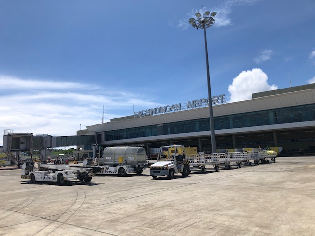
Back at Laguindingan Airport – departure
This is a very late post as I traveled to Cagayan de Oro months ago. I’m posting it here for reference.
 The main driveway at the terminal is reserved for VIPs’. I thought this practice in many airports in the country though claimed to be security-related is a waste of space and gives the impression that passengers are not the priority in these terminals.
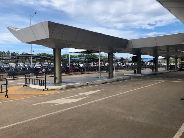 Another look at the airport’s spacious but underutilized driveways.
 Check-in baggage terminal at the airport – you can now get your luggage tags for items you’re checking-in and tag your bags or boxes yourself. This is supposed to reduce the transaction times at the check-in counters but I wonder if someone’s measuring or evaluating the process.
 Check-in counters for Cebu Pacific – they have 4 counters.
 Air Asia only had two counters at the airport. Meanwhile PAL had the more spacious area among the three airlines.
 The design is similar to Iloilo’s and Bacolod-Silay’s where passengers ascend to the departure level after checking in. There are a couple of shops under the stairs and escalator for last minute pasalubong purchases.
 PAL had the most check-in counters at 5. They had a separate counter for Mabuhay Class passengers that they also use for senior citizens and persons with disabilities.
 A look back at the check-in lobby
 Here’s what it looks like as we ascend to the departure level.
 After the final security check and entering the pre-departure lounge, you can proceed to the food court where you have a choice between Seattle’s Best Coffee and Kenny Rogers.
 Shops offer refreshments, snacks and pasalubong items.
 The passenger lounge appears to be spacious but can become crowded when there are flight delays.
 View of the various vehicles used in providing support services to the aircraft at the apron.
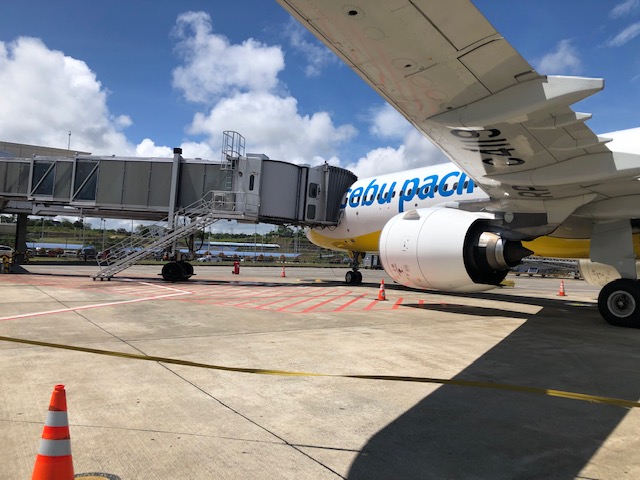 The view of our aircraft as we approach the stairs to the aft of the plane. Passengers seated from the middle to the rear of the plane are instructed to board the plane from the rear. Those seated from the front rows to the middle are instructed to board via the bridge or tube shown in the photo.
 Passengers boarding
I will be posting more photos of airports soon as I am traveling to Cebu and Kuala Lumpur in the next few weeks. It will be my first time to travel to KL (can you believe that) though it’s not my first time to Malaysia so that trip is something I look forward to and one that will definitely yield a lot of photos.
–
Article share: On the busiest shipping routes
Here is an article on maritime transportation. I don’t get to feature similar topics here as mostly I have written about land and air transport. I thought this article is interesting because it describes maritime transport traffic volume. Statistics like these appear to be trivial but are important especially from the perspective of logistics as well as, if you delve in to it, maritime security.
Piper, G. (July 11, 2023) “The busiest shipping routes in the world by the numbers,” Medium, https://grantpiperwriting.medium.com/the-busiest-shipping-routes-in-the-world-by-the-numbers-c09571ad5af6 [Last accessed: 8/2/2023]
To quote from the article:
“The vast majority of world trade sees Asia as the focal point. Both Europe and North America do heavy volumes of trade with Asia, mostly imports. But three of the five busiest shipping routes in the world are all internal routes. Europe-Europe, North America-North America, and Asia-Asia. That means that vast amounts of global trade are still relatively local.
Large importers like the United States and England drive massive amounts of trade. Large exporters, like China, Korea, and Japan, also drive massive amounts of trade. The areas where these terminuses link up are the busiest hotspots for global trade.”
A while back in 2004-2005, I was involved in an inter-regional passenger and freight flow study in the Philippines. We gathered data on maritime transport and were able to derive the OD tables for inter-regional and inter-island passenger and freight flow. Unfortunately, those studies and surveys had no follow-up or updating afterwards. There is a saying that “you can’t manage what you can’t measure.” This applies to transport as well so perhaps there are data somewhere and someone’s using them. We hope government agencies are able to collect the data required to analyze and improve maritime transport in the country.
–
Changing for the rains
A common seen these days of the wet season are motorcycle riders stopping to take out their rain gear to wear so they can continue with their travels. I’m not surprised that many if not most already have their rain gear ready if it rained and they needed to use them. Oftentimes, the location would be under any shade or shelter including underneath footbridges, waiting sheds or trees. If there were nowhere to seek shelter, they change right in the open. Following is an example where riders stopped at a parking area of a residential development to don their raincoats and jackets.

In the above example, riders do not impede traffic flow as they change off-street. In other cases though where they congregate under footbridges, they tend to block traffic and cause congestion where there was none. Perhaps there can be more areas or designated locations for changing to rain gear?
–
On using Google Maps to determine the best route from the pollution perspective
I saw this article on digital maps (i.e., Google Maps) being used to determine the best route for traveling between an origin and destination on land. It is interesting because what we usually use as basis for selecting our routes (assuming we can do so since people taking public transport basically have fewer options due to PUVs having mostly fixed routes) are travel time, travel distance and travel cost. Here is the article discussing the addition of fuel efficiency and emissions to the criteria:
Calma, J. (July 25, 2023) “People are using Google Maps to cut down tailpipe pollution,” The Verge, https://www.theverge.com/2023/7/24/23805652/google-maps-fuel-efficient-routes-transportation-emissions [Last accessed: 7/29/2023]
To quote from the article:
“According to Google’s own analysis, many drivers are taking the path of least pollution in their cars. To calculate the tailpipe emissions that prevented, the company compared how much fuel Maps users likely consumed on the routes they drove to how much fuel they would have burned through had they taken the fastest route without its eco-friendly routing tool. The savings amounted to 1.2 million metric tons of avoided CO2 emissions between October 2021, when Google launched the tool, and December 2022.”
While this seems to be a first foray into the including of eco-friendly items in route choice, these items are already and actually included in many travel planners including those used by people selecting which flights to take. We probably just didn’t notice them before or the information were not explicitly stated or posted. Would this really affect or influence the way we travel like how it is reported in the article? Or do we continue to go with the usual and familiar routes?
–
Bike lane master plan for Metro Manila, Metro Cebu and Metro Davao
The Department of Transportation (DOTr) with support from the United Nations Development Program (UNDP) yesterday formally launched the Bike Lane Master Plan for Metro Manila, Metro Cebu and Metro Davao. Yesterday’s event was actually the third and last leg of presentations, which were also made in Cebu and Davao. Here are a few photos I got from the DOTr Facebook page (these are public):
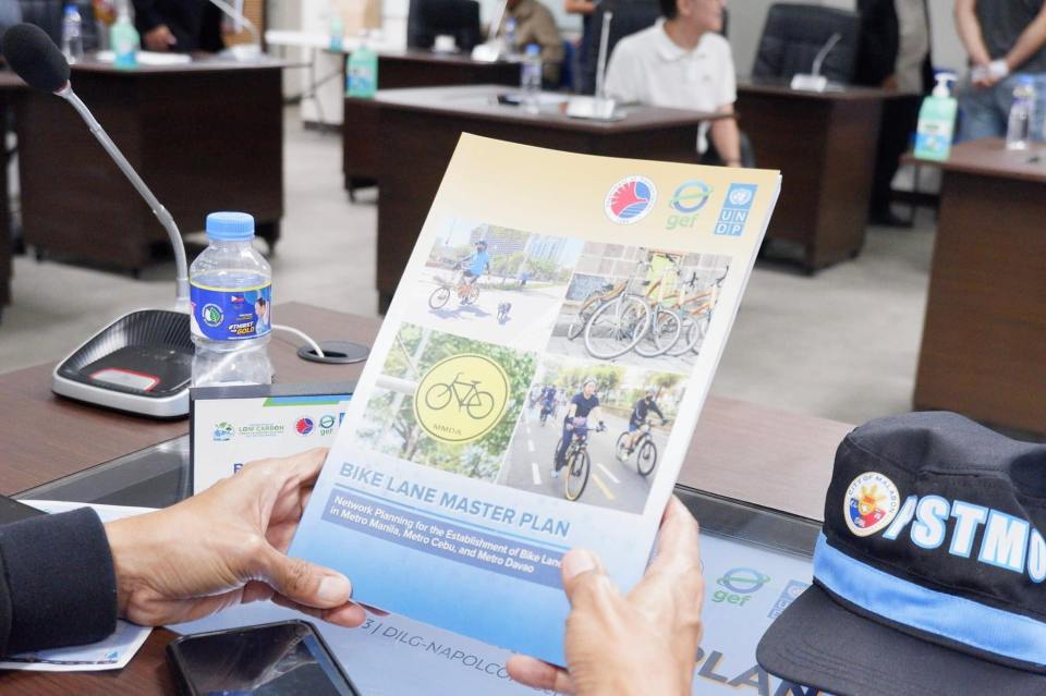 Printed copies of the master plan were distributed to attendees (Photo: DOTr Facebook page)
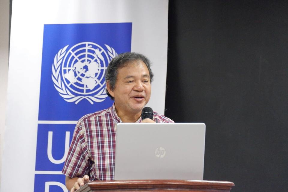 Dr. Ricardo Sigua of the National Center for Transportation Studies presented the highlights or key features of the master plan. The UNDP engaged NCTS to conduct the master planning project for DOTr. (Photo: DOTr Facebook page)
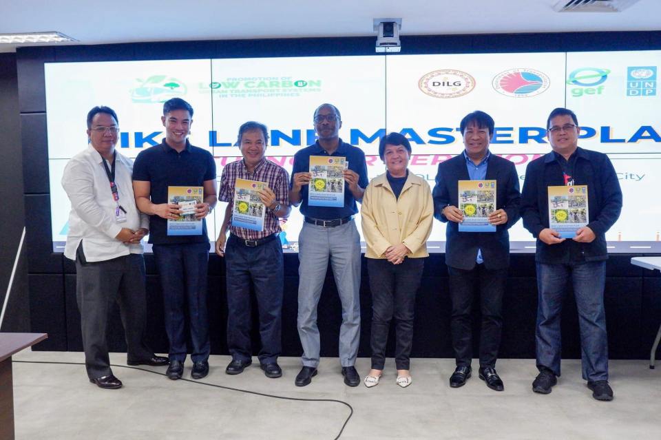 Photo op with participants from the MMDA (Photo: DOTr Facebook page)
While the master plan is most welcome as the country continues to build infrastructure for active transport (mainly walking and cycling), the launch is actually one year late. The project was actually completed last year and though most of the recommendations have yet to be carried out, many items including the inventories are already dated. These master plans though should not be static documents but dynamic in these sense that it would have to be updated regularly. For one, updates would provide the opportunity to reinforce or improve certain aspects of the plan. Updates also provide an opportunity to check whether progress is being made on the targets set in the plan. Also, since the master plan is for three metropolitan areas perhaps it can be part of the foundation for a nationwide plan. However, many plans fail if there is not support or scarce resources allocated for the implementation. Thus, there is a need for resources or allotments especially coming from government to support the realization of the plan.
–
