
Inflight snacks in the time of Covid-19
Inflight, there wasn’t really much difference pre-Covid-19 and now (not yet post-Covid-19) except perhaps that the flight attendants were wearing PPEs and masks. We were on full flights both outbound and inbound of Manila and the airport terminals were also already crowded. We flew on Philippine Airlines so there was no food and drinks for sale on the flight. But they did distribute some snacks and drinks to passengers.
 |
| Butter cookies and water were our inflight snacks for the MNL-TAG flight. For drinks you actually can opt for coffee or tea. |
 |
| The cookies were by Figaro and not from some obscure manufacturer. |
 |
| We had green peas and water on the TAG-MNL flight. |
 |
| Nutrition information at the back of the pack. |
 |
| The guisantes pack was manufactured in Cebu and is certified Halal. |
I assume that longer flights on board full service airlines like Singapore Airlines or Japan Airlines would have modified their inflight meals service in light of Covid-19. We are hopeful that we can soon travel overseas to again enjoy the attractions in other countries.
–
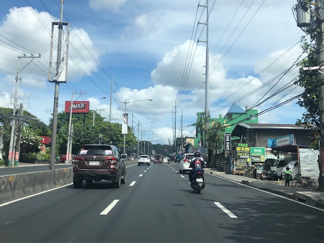
Flying again – NAIA Terminal 2 Departure
It’s been more than 2 years since the last time I went on a trip via aircraft. We finally decided it was safe to take a brief vacation and to take advantage of the still few tourists heading to resorts out of Manila. Here are a few photos taken at NAIA Terminal 2 as we set out to travel to Panglao Island in Bohol for a much needed break from work and from Covid-19.
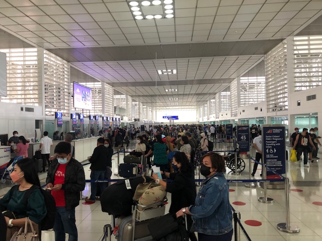
 Check-in counters at NAIA T2 were already busy when we arrived at the airport
 The scene at the terminal lobby was as if there was no pandemic (technically, we aren’t out of the Covid-19 pandemic yet).
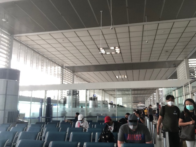
 Past the final security check and into the pre-departure area
 Some sections were less crowded. This section where we had some light lunch as we waited for our gate to be announced was usually reserved for international flights. Here were gates for US destinations and it was spacious because of the number of passengers and the gauntlet-like security checks required for US-bound passengers.
 Our boarding gate for our flight to Tagbilaran-Panglao Airport
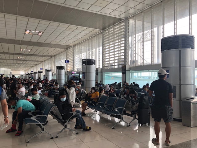 Passengers waiting for their boarding calls near our gate
We can only imagine how much more crowded this terminal could still be once we go back to “normal” or pre-pandemic travel conditions. It is good to see at least most passengers wearing masks. All adults at least were wearing masks and only small children and infants weren’t. We also hope that airport terminal staff do their part in ensuring the facilities were disinfected regularly so as to minimize the risk of Covid-19 and other infections.
–
Island hopping again
It’s been more than two years since we last traveled by plane and 10 years since our visit to Panglao in Bohol. So its really something we looked forward to considering we now travel with our daughter and there’s a lot to write about on the experiences.

And there’s a lot about transport to write about and share in this blog. There’s a new airport, the nice roads and the journey between Panglao and Balicasag, among others that I will be writing about soon.
Abangan!
Where do trucks fit in complete streets?
The complete streets concept usually involve transforming streets to favor active and public transport. The typical discussions and presentations on complete streets are often focused on taking away road space from cars to allocate to pedestrians (e.g., wider sidewalks), cyclists (e.g., bike lanes) and public transport (e.g., transit lanes). Seldom do we read about trucks, deliveries and related items even in guides and manuals and are often just implied to be addressed in street transformation examples.
Evans, T. (March 24, 2022) “”Complete Streets” and Goods Delivery: What are Streets For?” New Jersey Future, https://www.njfuture.org/2022/03/24/complete-streets-and-goods-delivery-what-is-a-street-for/ [Last accessed: 4/5/2022]
To quote from the article:
“Not every final destination for a package needs to be accessible to large trucks. Rather than proposing truck-focused modifications (wider lanes, bigger turning radii, etc.) to local streets in order to accommodate truck deliveries, transportation planners and logistics industry professionals should focus instead on matching the type of delivery vehicle to the environment in which the destination is located.”
I recall the mainly pedestrianized shopping streets (shotengai) in Japan when I try to make sense of how delivery vehicles can be included in the discussion. The Japanese use small trucks or vans for deliveries and mostly these are confined to the side streets. However, during certain times of the day, usually early mornings or after business hours, they are allowed inside the shopping street for quick deliveries or pick-ups. This show what kind of goods vehicles and operations may be permitted.
–
History: article on how jaywalking came to be
I am sharing this article on the invention of jaywalking. It is a very informative articles and gives context to the current situation where cars dominate streets and car-centric policies and infrastructure diminish pedestrians and walking. I’ve always said that history should enlighten us about how it was, how it came to be and what we need to change now if we are to attain a more sustainable transport system that will contribute to improving safety and ultimately, quality of life.
Thompson, C. (March 29, 2022) “The invention of ‘Jaywalking’,” Marker, https://marker.medium.com/the-invention-of-jaywalking-afd48f994c05 [Last accessed: 4/2/2022]
To quote from the article:
“It’s not totally clear who invented the phrase, but it was a fiendishly clever portmanteau. In the early 20th century, the word “jay” mean an uncultured rube from the countryside. To be a “jaywalker” thus was to be a country bumpkin who blundered around urban streets — guileless of the sophisticated ways of the city…
Ever after, “the street would be monopolized by motor vehicles,” Norton tells me. “Most of the children would be gone; those who were still there would be on the sidewalks.” By the 1960s, cars had become so dominant that when civil engineers made the first computer models to study how traffic flowed, they didn’t even bother to include pedestrians.”
The article showed photos of pre-automobile times in the US. Here’s a photo of pre-automobile Manila for context:

And here’s Manila during the American period but with most people walking or taking public transport in the form of the tranvias:

Chaotic as the scenes appear to be, these streets were definitely safer and perhaps saner than what he have now. The challenge is how to re-orient our streets and reclaim it to favor people instead of cars.
–
On the number coding options for Metro Manila ca. 2022
The Metropolitan Manila Development Authority (MMDA) recently announced that the agency was studying options for a new number coding scheme under its Unified Vehicular Volume Reduction Program (UVVRP). UVVRP is basically a travel demand management (TDM) program focused on vehicle use restraint. In this case, private vehicles, particularly cars, are the target of volume reduction. Here’s a graphic from their Facebook page:

The schemes are not really new as these were also considered before. Are the conditions new at all? Are we assuming things changed due to the pandemic? Or will there just be a return to the old normal in terms of traffic congestion? Here are some past writings on the topic including a 3-part series I wrote back in May 2011:
- From Odd-Even to UVVRP…and back
- Traffic congestion in Metro Manila: Is the UVVRP Still Effective? – Part 1
- Traffic congestion in Metro Manila: Is the UVVRP Still Effective? – Part 2
- Traffic congestion in Metro Manila: Is the UVVRP Still Effective? – Conclusion
I think many of the arguments I made in those more than decade old articles hold or apply to the present. Even with the increasing popularity of active transport in the form of bicycle facilities appear to have not made a dent to the transport problems in the metropolis. Many questions abound and I have seen and read comments pointing to the many transport infrastructure projects currently ongoing around Metro Manila as proof that transport and traffic will be improving soon. Transportation in general may indeed improve once the likes of the Metro Manila Subway, Line 7, Line 1 Extension, and the PNR upgrades come online (i.e., all operational) but we have yet to see their impacts outside the models created to determine their potential benefits. Will they be game changers? We do hope so. Will UVVRP be needed in the future when these mass transit lines (including others in the pipeline) are all operational? Perhaps, but a scaled down version of this TDM scheme might still be needed and may suffice if people do shift from their private vehicles to public transportation. The fear is that most people eventually taking the trains would be those who are already commuting using road-based public transport like buses, jeepneys and vans. If so, the mode share of private transport will not be reduced and those traffic jams will remain or even worsen. Maybe we should be discussing road pricing now?
–
On asphalt overlays and opportunities to rationalize pavement markings
Entire road sections along my commuting routes have had recent asphalt overlays or are being prepared for it. This is part of the national government’s regular maintenance program for roads implemented by the Department of Public Works and Highways (DPWH).
 Newly asphalted pavement along the eastbound section of Ortigas Avenue Extension – can you guess how many lanes will fit here?
The previous photo was taken one week ago. This is what the section looks like after the contractor restored the pavement markings. I say restore because these are practically the same 3 lanes prior to the asphalt overlay to the rigid pavement structure.
 Pavement marking delineating the traffic lanes, median and gutter
I wonder if the DPWH included bike lanes when they contacted the asphalt overlay and pavement markings for this road. There was none before and the new overlay presented a blank slate to which Class III bike lanes could at least have been provided. There is already an increasing number of bike-to-work traffic along Ortigas Ave. Ext. and the Manila East Road, which connects the large towns of Rizal and serves as one of the major arterials connecting the Province of Rizal to Metro Manila (the other being Marcos Highway).
Asphalt overlays like this provide opportunities to rationalize road space through adjustments to the pavement markings. Granted that there’s significant bus and truck traffic along this road, it is still possible to allocate or at least delineate 1.5m to 2m for cyclists. That should also help in making motorists aware of bike traffic and in the long run influence behavior towards safer travels for all road users.
–
Some old drawing tools for clothoids
I took some photos of old (vintage if you prefer) drawing tools that I have at our laboratory at the university. We found this in the storage many years ago and people seem to have forgotten about them. Instead of heading for storage or being forgotten or worse, thrown away, we decided to keep them at our laboratory mainly to show our students how certain highway or street curves were drawn in the ‘old days’. I am currently the custodian of this and another set that I have kept at my other office at the civil engineering building.
 The wooden box is at my office at UP Diliman
 The sign basically translates to clothoid drawing tools made by a company based in Setagaya in Tokyo. There are 14 instruments in the box for clothoid parameter values of A = 20m to 350m.
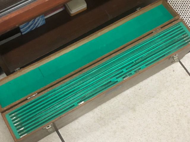 Opening the box shows slots holding instruments for drawing clothoids or spiral curves
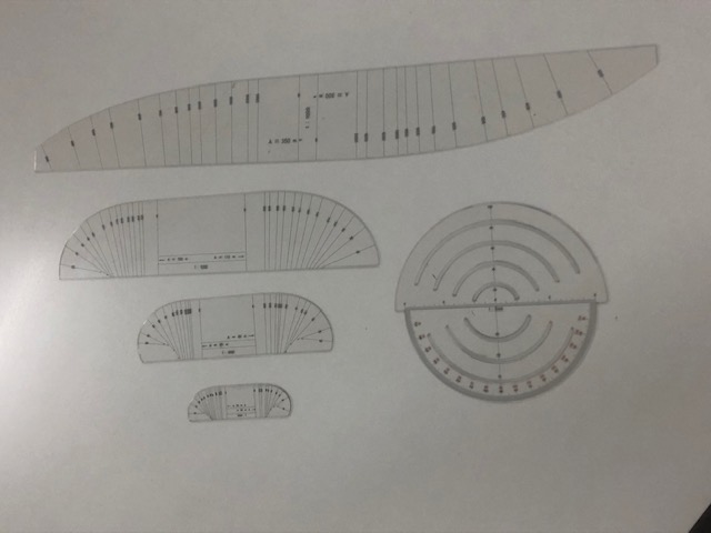 Some of the instruments from the case – the large one on top is for A = 300m and 350m (scale 1:1000)
 Comparison of size of instruments for (top) A = 60m and 65m, and (bottom) A = 30m and 35m (scale 1:1000)
 Instrument for A = 30m and 35m (Scale 1:1000)
 A protractor came along with the set but I assume other instruments such as a compass were used in drawing/drafting the curves.
I shall take photos of the other set when I get to visit the other office. These will be for records purposes as well as for posterity. These are practically museum pieces that are now perhaps rarely if even used.
–
On the future on urban transportation
I’m sharing the following article on the idea of mobility hubs in cities:
Descant, S (March 16, 2022) “Are mobility hubs the future of urban transportation?” Government Technology, https://www.govtech.com/fs/are-mobility-hubs-the-future-of-urban-transportation [Last accessed: 3/18/2022]
To quote from the article:
“As cities reimagine transportation and transit, they’re turning toward innovative attempts to bring multiple modes together, with the essential aim of making it easier for residents and others to choose a mode of travel other than the single-occupancy car.”
Though I support this idea, I think it only implies that housing issues are already covered. In reality, there should be clear-cut and simultaneous initiatives covering both housing and transport. In Metro Manila’s case, for example, the sprawl is over a much wider area and covers at least 4 provinces surround the metropolis where people have chosen to settle/reside due to the high and rising cost of housing in the MM. While the example of Tokyo and its railway lines may be used as inspiration, it will take a lot for Metro Manila to have such a transit network to carry so many people around MM+.
–
Trivia: Why are school buses yellow?
Have you every wondered why are school buses yellow? Of course, the main reason is safety related. Here is a short article on why the color was chosen for school buses:
Ganninger, D. (August 20, 2020) “Why are school buses yellow?” Medium.com, https://medium.com/knowledge-stew/why-are-school-buses-yellow-2f2b063739d4 [Last accessed: 3/20/2022]
To quote from the article:
“The original color was called National School Bus Chrome but has since changed since school bus chrome contained lead in the pigment. The color was adopted because black lettering was easy to see in the early morning hours and during the late afternoon. Another reason it was chosen was because the color yellow is seen quickly in someone’s peripheral vision.”
–
