
Flash floods in Quezon City
The rains poured again this afternoon and it was quite intense for more than an hour in Quezon City. We had floods at the UP campus and along Katipunan Avenue. Reports from various sources stated that there were also floods along EDSA and other major roads in the city. The floods come at a time when QC flagged flood control projects undertaken by the DPWH without the city’s blessings.
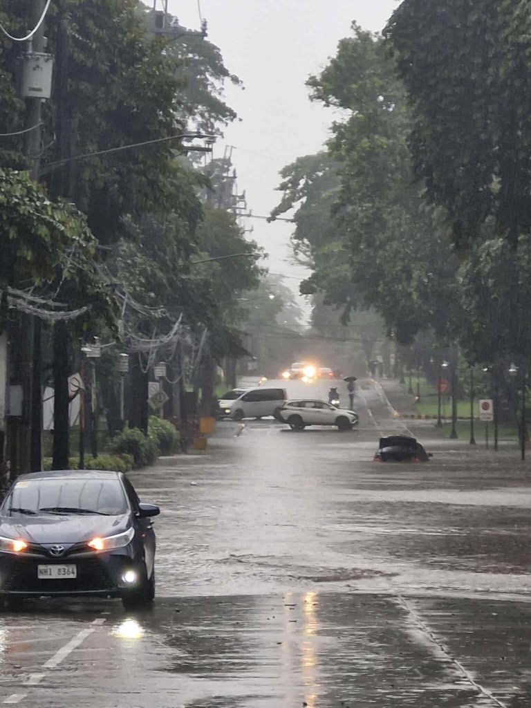
The flash floods were probably proof of the shoddy work associated with DPWH and its contractors. While QC residents and the LGU should share the blame for these, the scale and frequency of the floods indicate drainage issues.
The floods have led to intense traffic congestion and commuters being stranded due to public transport vehicles not being able to turn around. The latter is one of the cases where public transport appears to be lacking. Their numbers may not be lacking at all but the traffic conditions prevent their turnaround to address the demand for transport.
–
On safety along boring roads
I saw this interesting article about “boring” roads. It seems to be consistent with anecdotal evidence about ordinary roads with unremarkable features especially along adjacent lands. What may be termed as “beautiful” and “remarkable” may not necessarily be distractions to road users. Rather, it may keep people’s attention on the roads and people outside cars or, as the article refers to them, non-motorist car injuries or fatalities. There seems to be some confusing outcomes or perhaps confusing use of terminology in how the article is written (i.e., how perceptions are stated in the article).
Wilson, K. (August 21, 2025) “Study: Boring Roads End Up With More Injuries For People Outside Cars,” Streets Blog USA, https://usa.streetsblog.org/2025/08/21/study-boring-roads-end-up-with-more-injuries-for-people-outside-cars [Last accessed: 8/27/2025]
Quoting from the article:
“Researchers at the University of Connecticut recently analyzed the emotional reactions of more than 81,000 volunteers to a trove of Google Street View images from 56 cities around the world — and found that certain recurring perceptions correlated tightly with how many car crashes involving vulnerable road users actually happened where those photos were taken.
Perhaps unsurprisingly, the participants were pretty good at gauging whether a road was “safe” for walking and biking just by eyeballing it and reporting on how safe it made them feel in general, adding further evidence to the pile that “perceived safety” is a critical metric that every transportation leader should take seriously. Streets that volunteers perceived as “wealthier” also tended to record lower crash volumes — which also might be intuitive, considering that some of the most obvious signs of neighborhood affluence can be great public infrastructure like smooth sidewalks, pristine bike lanes, and ample street lighting.
Roads that were rated as “lively,” meanwhile, were associated with higher crash volumes — though the researchers were careful to note that may just be because there were more people in those images, and crash rates per capita, or per pedestrian- or bike-mile traveled, might actually be lower in hopping human-centered areas.”
In that last paragraph, the term “lively” might have different perceptions depending on the people looking at images of streets. In our case, the street scene in Divisoria, for example, can be described as “lively” yet it may be safer than what is perceived in other countries, especially in the west. I think we have to be careful with the kind of studies as described in the article and to be fair, they did say that their study is still at an exploratory stage.
–
Our clear and present problem with DPWH and certain contractors
I was going to write about the new taxi service and TNVS I used recently during this long weekend. Unfortunately, I lost focus and “gana” after reading about the collusion among DPWH officials and certain contractors about flood control projects. Here are my sentiments today that I shared on my social media account:
“Bakit walang pasok bukas? Kasi may nagbabadyang masamang panahon. Baka bumaha? Bakit babaha? Alam na siguro natin ang sagot sa tanong na ito? Damay-damay na yan. Resilience na lang ba ng mga taong nagbabayad ng buwis ang kasagutan? Di ba dapat may managot sa kung bakit patuloy tayong binabaha samantalang bilyones o trilyones ng kaban ng bayan ang ginagastos? Naiisip ba natin na yung pinagpaguran, pinagpapaguran at pagpapaguran natin ay napupunta sa mga nanlalamang? Wala nga siguro silang nararamdaman at napapansin habang nakasakay sa kabilang magagarang sasakyan. Tayo naman, hanggang tiis sa paglusong sa baha at mag ‘abangers’ sa anunsyo ng walang pasok.”
With the recent revelations of these contractors having the propensity to purchase luxury items like expensive vehicles, do we still wonder why these people cannot feel what ordinary people experience during these times of inclement weather? Hindi nga siguro maramdaman ang baha o ang mga lubak sa daan pag naka SUV ka. To be quite direct about this, I would like to personally drag them to experience the floods and maybe submerge their homes for a few days so we’re even. I am probably not alone with my sentiments.
Flood control is probably just the tip of the proverbial iceberg. There are just so many other projects including roads and bridges that also need to be investigated for anomalies. Will the current administration act on this? Or are we just being taken for a ride with all these lip service and grandstanding by politicians and government officials?
–
Is it possible to have zero traffic deaths in a year?
Is it possible to have zero traffic deaths in a year? Is it even probable? As it turns out, yes. Here’s an article on what Helsinki did in order to make this a reality:
Andrei, M. (August 1, 2025) “Helsinki went a full year without a traffic death. How did they do it?” ZME Science, https://www.zmescience.com/science/news-science/helsinki-went-a-full-year-without-a-traffic-death-how-did-they-do-it/ [Last accessed: 8/19/2025]
To quote from the article:
“A lot of factors contributed to this, but speed limits are one of the most important,” said Roni Utriainen, a traffic engineer with the city’s Urban Environment Division.
More than half of Helsinki’s streets have a speed limit of 30 km/h (approximately 20 mph). Half a century ago, the city barely had half of its area with a 50 km/h limit (30 mph). They gradually worked to reduce the speed limit, especially around schools and kindergartens.
Smarter street design also played a key role. Pedestrian and cycling infrastructure was prioritized for upgrades in recent years. More and more people started using public transit or bikes, or just walking. Substantial investments also made public transit more efficient and reliable.“Public transport in Helsinki is excellent, which reduces car use, and with it, the number of serious accidents,” Utriainen noted.
Another key component was bringing the police on board. Helsinki introduced automated traffic cameras and enforcement systems, which also helped bring down reckless driving.”
Examples of congestion pricing as applied in major cities
Here is a quick share of an article on cities that have been successful with congestion pricing:
Zukowski, D. (August 8, 2025) “5 cities with congestion pricing,” Smart Cities Dive, https://www.smartcitiesdive.com/news/5-cities-with-congestion-pricing/756987/ [Last accessed: 8/15/2025]
Quoting from the article:
“As cities around the world continue to see increased traffic delays, some have implemented congestion pricing programs to ease gridlock. Congestion pricing acts as a market-based mechanism: increasing the cost to drive in certain areas may encourage drivers to take alternate means of transport or travel at different times. Toll revenues can go to improving roadways and public transit or reducing other vehicle-related taxes.”
Indeed congestion pricing has been around and yet few cities have actually implemented congestion pricing schemes and have had success with it. In the Philippines, the discussions are basically on and off or intermittent. I recall there were already mention of congestion pricing in Metro Manila transport studies back in the 1970s but nothing really came out of those. Fast forward to the present and Baguio City in the northern Philippines implemented their version of number coding, which was supposedly a prelude to some form of congestion pricing but apparently is more of a travel demand management (TDM) scheme along the lines of Metro Manila’s UVVRP. Will we have our own proof of concept sometime soon even for a smaller area or district in any Philippine city? That will also be dependent on whether our so-called leaders can engage their constituents in meaningful discussions on the benefits of congestion pricing.
–
On posting the correct information on buses
I took this video on the way home via Ortigas Avenue Extension. The destination of the bus showed it is en route to the Guangzhuo Train Station. Apparently this not just for this bus but for others like it (same model).
While this is basically a minor or trivial thing, bus companies should still be providing the correct information on their buses. This is part of the service they provide to commuters.
–
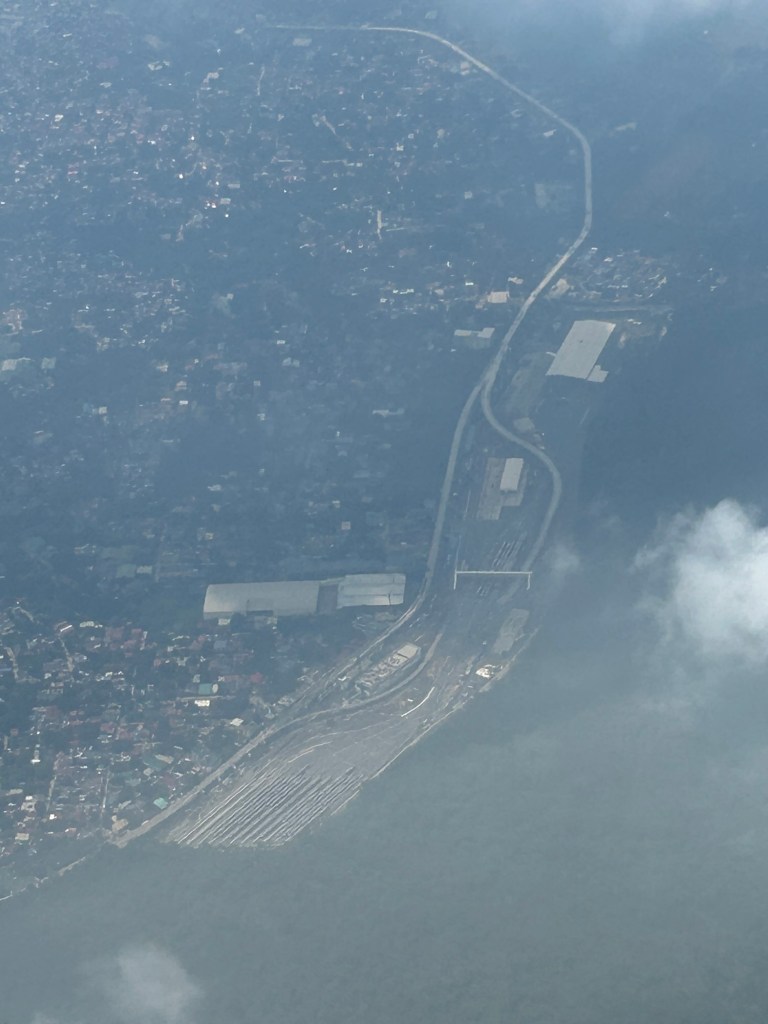
Aerial photo of the MRT7 depot?
I took this photo of what appears to be the MRT7 depot near or adjacent to the La Mesa reservoir. It was as quick a photo as our plane was banking into the clouds.
–
An aerial view of the PNR’s rail revival
I would just like to share a few photos I took while our plane was turning towards our Bicol destination upon take off from NAIA.
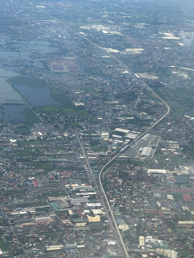
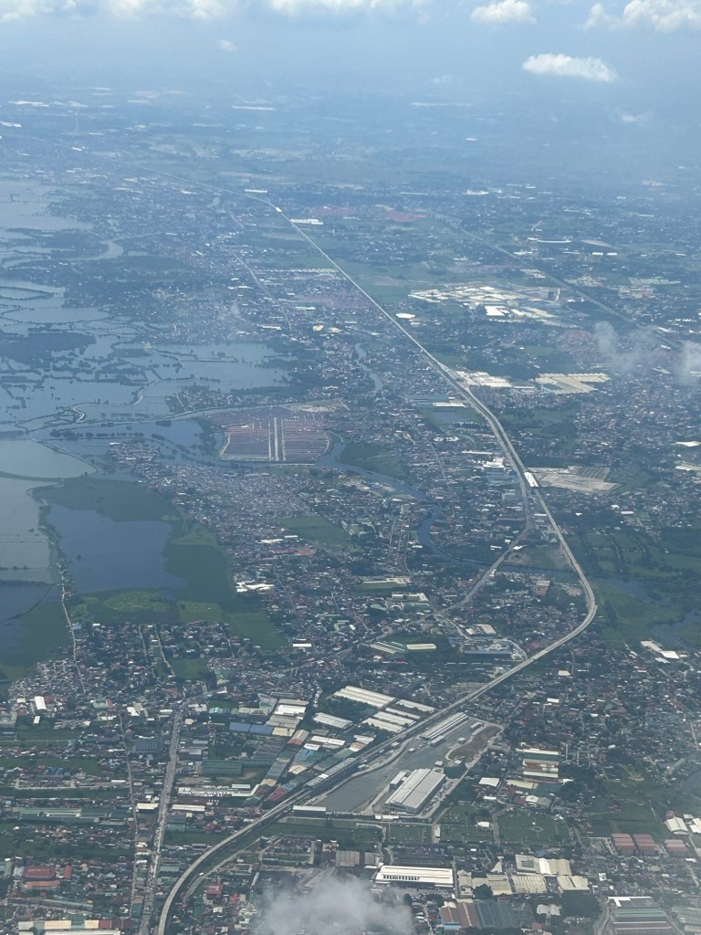
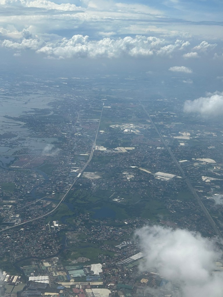
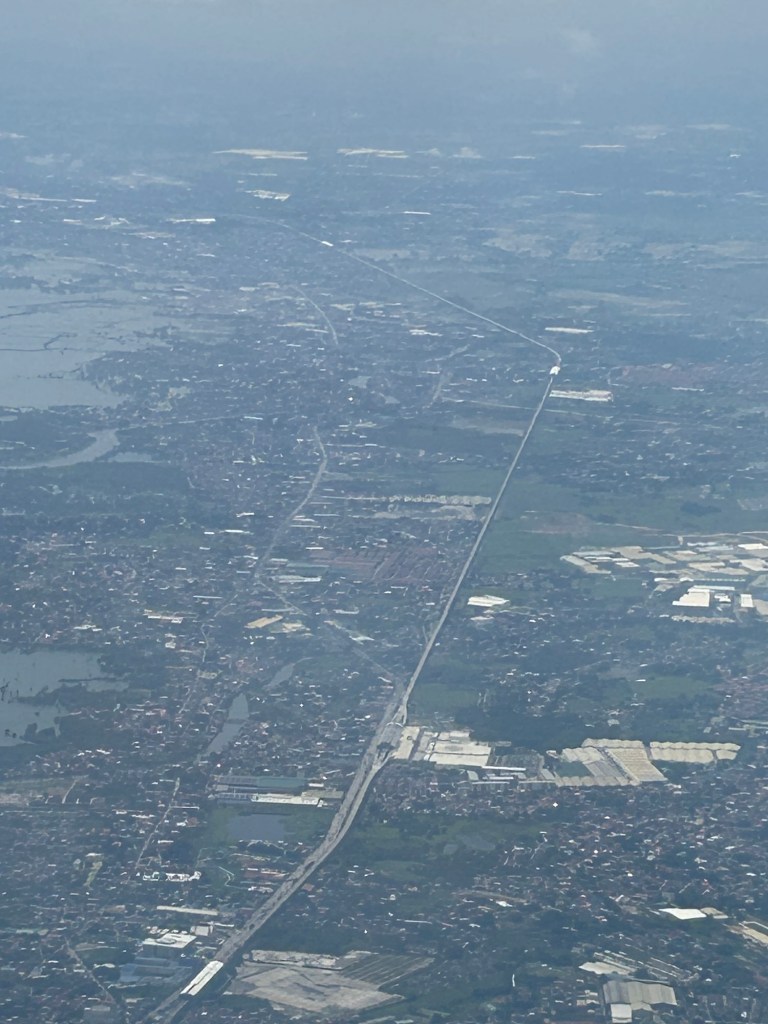
I will again pose the following questions to my readers: will the NSCR become the game changer it’s supposed to be for both long distance travel and commuting (super commuting for some cases)? Will it decongest McArthur Highway and NLEX? Will there be a significant shift from car use to rail? Or will those taking road-based public transport be the ones mainly shifting to rail?
–
Is there really a shortage of public transportation in Metro Manila? – Part 1 – Introduction
I will be doing a series of articles here on public transportation. More specifically, I will try to answer the question in the main title of the series – Is there really a shortage of public transportation in Metro Manila?
The quick answer probably is “yes” but we need to examine this concern from different perspectives and reasons so we can be objective about the “why” part of the shortage. Shortage may mean a real lack in terms of the number of public utility vehicles (PUVs) with approved franchises or perhaps the number actually operating on any given day. These two are actually different because it is possible to have fewer PUVs operating compared to the approved number or to have more PUVs operating than the approved number. The latter means there are “colorum” or illegal operations (i.e., vehicles providing public transport services without franchises).
Among the reasons why there is a perceived shortage of public transportation are as follows:
- Fewer than the number of franchises approved are operating.
- PUVs are not able to make a reasonable turnaround (e.g., due to traffic congestion).
- PUV drivers and operators refusing to operate their vehicles.
- Other factors.
- Any combination of the above including “all of the above.”
I hope I can write about these in a manner that can be easily understood – in layman’s terms.
–
Complex intersections in Davao City
My first project upon my return from Japan in 1999 was the Davao City Transportation and Traffic Management Plan Study. We found a few interesting intersections there. These included junctions with more than 4 legs. If all or most movements were allowed at these intersections, they would be most complicated and risky due to the number of conflicts. Of course, not all movements are allowed and many legs are one-way meaning there are fewer conflicts and less risky.
 These intersections are large and while there are traffic signals, they were off when I was there.
 Surprisingly, there was no congestion or near crashes. Either, traffic was light at the time (before 7AM) or motorists were driving at a level similar to Vietnam (where vehicles were like ants as they moved at intersections).
A bit of trivia here – 1999 to 2002 was the only period in a long time when a Duterte was not mayor of the city. This was the time the former president relinquished the mayoralty in favor of his Vice Mayor and was instead congressman representing the city. He immediately returned after one term rather than serve out 3 terms.
–
