
Home » Disaster (Page 2)
Category Archives: Disaster
On trees as solution to many of our urban problems
I am sharing this nice article on trees being the solution to many of our urban problems. I think many people have come to notice the importance of trees and the role they play with the increasing temperatures (i.e., heat) we’ve experienced the past years. The science on this state much more and covers not just temperatures but flooding, energy and infrastructure as well. Discussions and examples on these are in the article:
Durand-Wood, E. (August 8, 2024) “The Multi-Tasking Marvel: How Street Trees Can Solve Many Municipal Problems,” Strong Towns, https://www.strongtowns.org/journal/2024/8/8/the-multitasking-marvel-how-street-trees-can-solve-many-municipal-problems [Last accessed: 8/28/2024]
To quote from the article:
“Planting and maintaining street trees is an investment, but it’s one that pays for itself over and over again. Cities around the world are starting to calculate the economic value of their urban forests, a task made feasible with tools like i-Tree.
And more research is finding that trees pay for themselves many times over. A U.S. Forest Service study “conducted in five U.S. cities found that every dollar invested in the management of urban trees [ …] yields annual benefits of $1.37 to $3.09.
Trees are also the perfect example of a small bet. They cost relatively little, but the many varied returns are so high.”
–
On transportation and floods
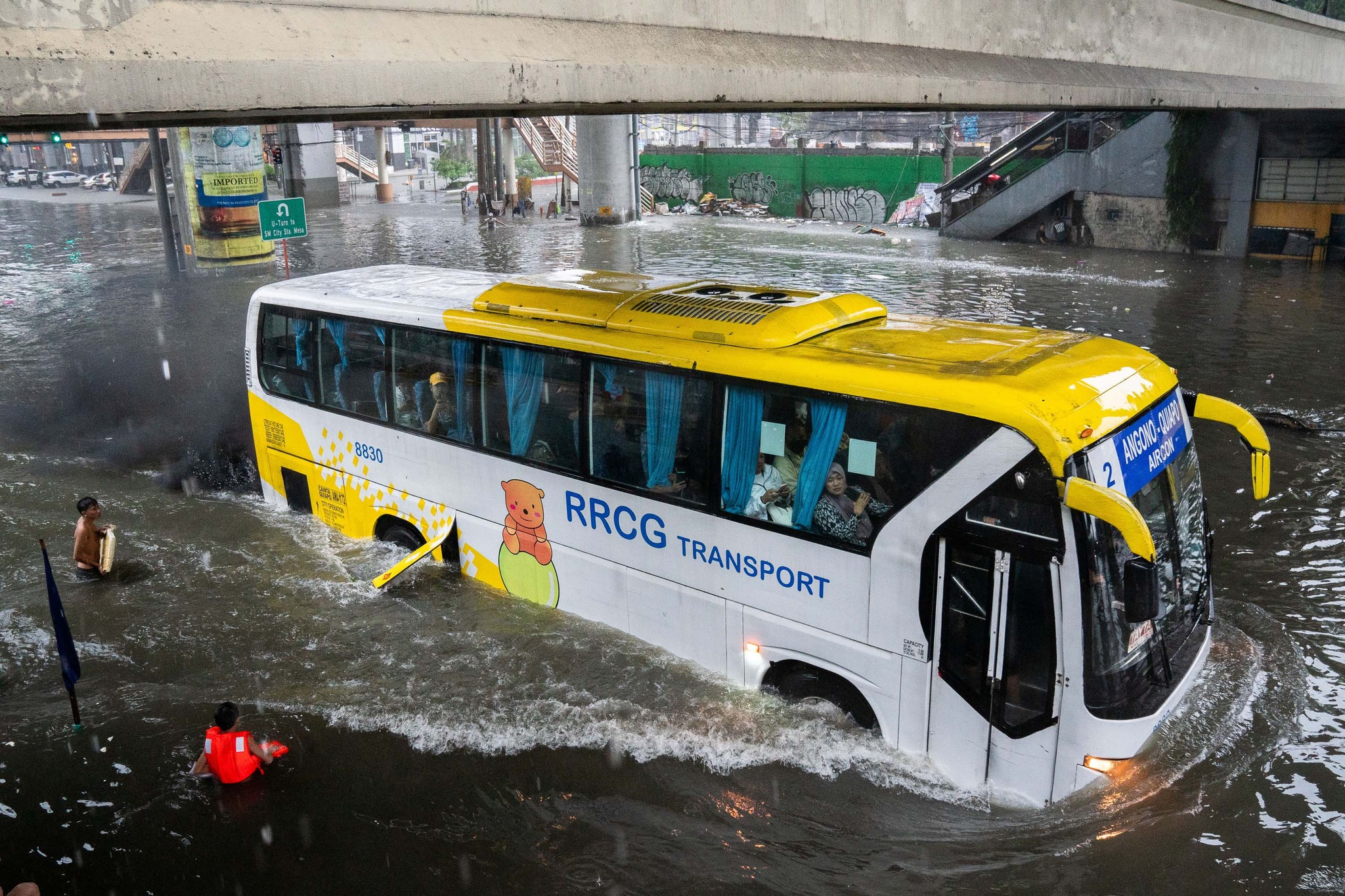
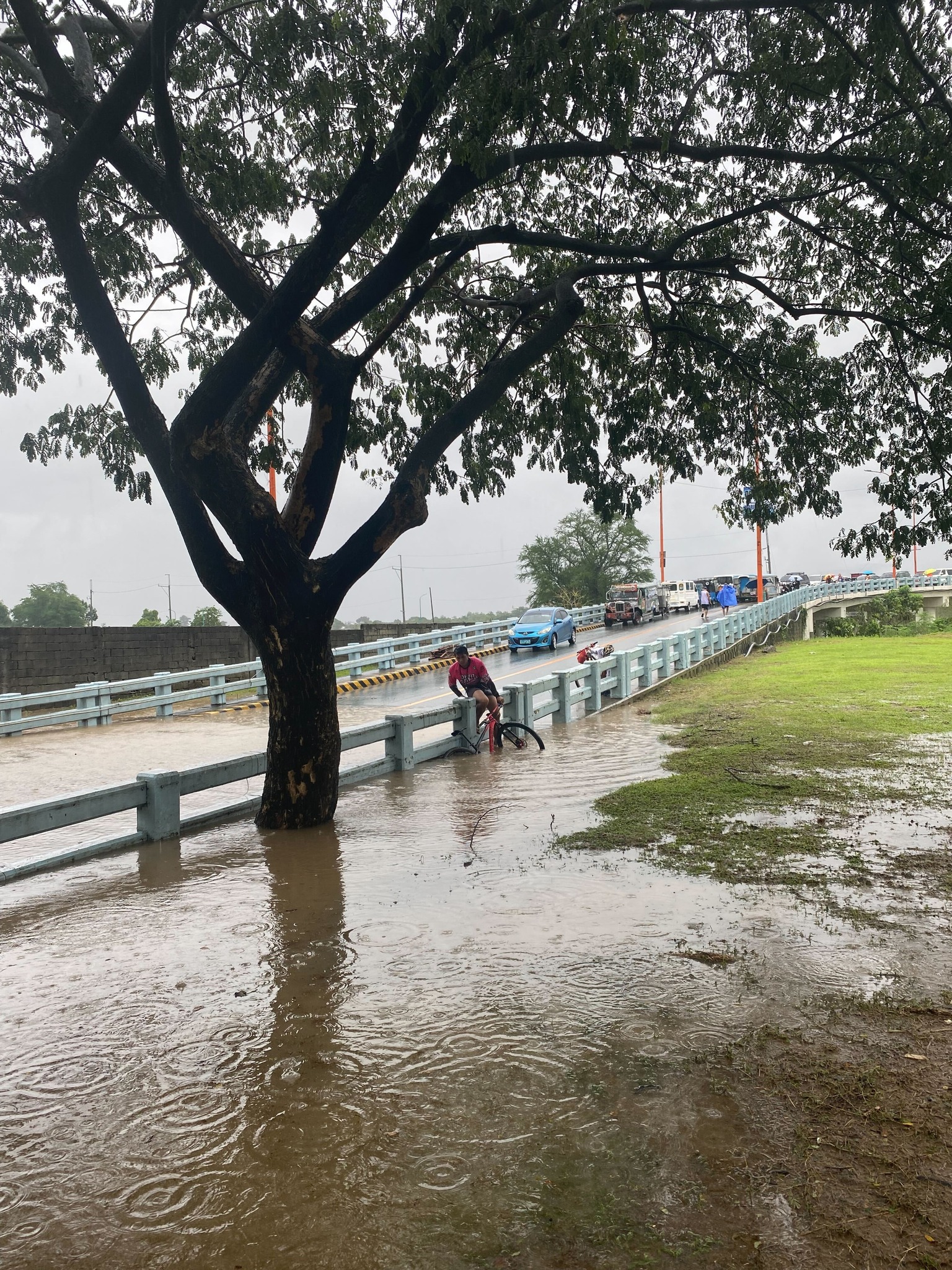
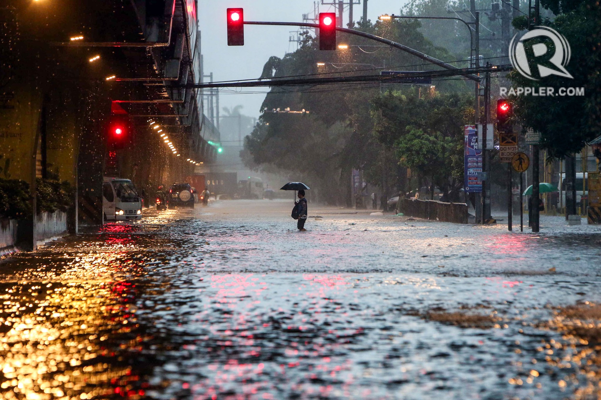
Some people say transport and traffic concerns take a backseat to floods and related concerns, which affect other aspects of our lives aside from our commutes. The heavy rains the past days have rendered many streets impassable to most types of vehicles. That means people cannot go to work, school or come home. Lives are disrupted by floods this way. But even more disruptive and disastrous are the damages brought about by flooding in many communities. Homes are submerged. Properties are damaged, many beyond repair or replacement. There is also the psychological aspect of floods especially for those who will experience them for the first time. These will surely add to the already fragile mental health of people still reeling from the effects of the COVID-19 pandemic.
As I write, the Marikina River has breached and many areas of Metro Manila and surrounding provinces of Bulacan, Rizal, Laguna and Cavite are flooded. The floods are now being mentioned along with those brought about by Ondoy (Ketsana) in 2009.
Here are some photos from the internet being shared by various social media accounts including the official pages of Rappler and Inquirer:
–
Extreme turbulence during air travel
Transport-related news last week included a report about a Singapore Airlines B777 jet flying to London from Singapore that had to make an emergency landing in Bangkok due to extreme turbulence experienced. Many people were seriously injured when the plane suddenly ascended (“tilted up” as some news reports state) and then abruptly descended, resulting in people being tossed up and hitting the compartments above their seats. Obviously, these passengers were not wearing their seatbelts at the time. Otherwise, they would have been restrained to their seats. It is likely that the turbulence was not anticipated by the pilot as they usually advise passengers to put on their seat belts if turbulence was expected at any time during a flight.
The incident raises concerns about extreme and sudden turbulence occurring during flights. I guess this may happen anytime and aircraft instruments may not be able to tell the crew about an impending incident like this. Will such an incident have a significant impact on air travel? Perhaps not if these incidents remain rare. There should be records and monitoring of factors or elements leading to such incidents in order to establish the likelihood of these happening. Incident records will also show if there is an increasing frequency as well as the number of people killed and injured. Such information would be vital as more people use aviation for travel and there are more aircraft activity around the world.
As a precaution, it is good practice not to remove your seatbelt while seated in flight. If it’s tight, then loosen it. At least you have some restraint in case of incidents where the aircraft encounters sudden turbulence.
–
Article share: on the collapse of a bridge in Baltimore
The recent incident of a container ship colliding with the bridge in Baltimore in the US has been trending and gone viral. There are also many articles now putting out their assessments of what happened, how the bridge collapsed, what troubled the ship, etc. There are also now articles discussing the implications or the impacts of this incident on logistics considering the collapsed bridge lies along a busy maritime route in the US. Here is an article that focuses on the former, providing analysis on how the ship caused the collapse of a major bridge.
Laris, M. Hassan, J. and Achenbach, J. (March 26, 2024) “How a cargo ship took down Baltimore’s Key Bridge,” The Washington Post, https://www.washingtonpost.com/dc-md-va/2024/03/26/how-key-bridge-collapsed-baltimore/ [Last accessed: 3/27/2024]
What also came to mind as I read reports about this incident is something similar that could happen to the CCLEX bridge connecting Cebu and Mactan Islands. Apparently, something similar already happened decades ago when a bulk carrier, Sanko Elegance, collided with the pier of the first Mactan Bridge. While the bridge did not collapse, it sustained damage that required it to be repaired and severely affected traffic between the two islands considering it was the only bridge at the time. It is important to note that the airport was on Mactan Island so it affected both passenger and freight flow for the province and others that connect and trade with it. While a former student who was much involved in the construction of the CCLEX bridge assured us in a briefing before that the bridge pier can withstand the collision of large vessels (perhaps the largest currently calling on Cebu ports), there may be larger and heavier ships in the future. The Key Bridge, after all, was hit by a container carrier that was larger than the ships transiting in the area when the bridge was designed and constructed.
–
Article share – on aircraft evacuations and the case of JL516
Here is a very informative article on aircraft emergency evacuations, particularly the case of the recent JAL 516 where all passengers and crew were able to evacuate the burning aircraft.
Tamura, Y. (January 7, 2024) “Why the Evacuation of 379 Passengers from the Burning JAL516 Wasn’t a Miracle,” Medium, https://medium.com/japonica-publication/why-the-evacuation-of-379-passengers-from-the-jal-collision-wasnt-a-miracle-8a03cb02a95c [Last accessed: 3/4/2024]
To quote from the article:
“Japan is said to have become earthquake-resilient over the decades, but it’s less known that the same applies to aircraft accidents.
As the oldest Japanese airline company partially founded by the government in 1951, the history of JAL encapsulates the narrative of Japan’s aviation industry, punctuated by significant accidents.
It is none other than JAL that experienced the worst-ever airplane crash in the world. In 1985, JAL123 crashed into a mountain approximately 100 km from Tokyo.
The crash, believed to have been triggered by improper maintenance of the aft pressure bulkhead, caused 520 fatalities, the largest loss of life in a single aircraft.A former JAL employee comments that those who have survived traumatic incidents often grapple with returning to their duties in the sky. Despite this difficulty, they also carry a deep sense of responsibility to impart their experiences to younger crew members, contributing to the commitment to safety.
I agree that the successful evacuation was not a miracle but a product of the training and dedication of the staff as well as the culture and behavior that was very obviously Japanese. One wonders what could have happened if this were, say, an airliner from a third world country? Or perhaps even one from a country like the US? Would the evacuation have been successful like JL516’s?
–
On recent airline incidents in Japan and the US
There were two recent incidents involving airlines the past days. One was on a collision as a Japan Airlines Airbus A350-900 jet arrived at Haneda Airport in Tokyo. The other was a midair incident where an Alaskan Airlines Boeing 737 Max 9 plane lost part of its fuselage. While both are troubling, the first incident provided a good example of how emergency evacuations should be. The second incident reminds us of the importance of aircraft maintenance and tests to make sure planes are safe for use by passengers.
To quote from a New York Times article on the Haneda Airport incident:
“In addition to a well-trained crew and an advanced plane, the safe evacuation of 367 passengers came down to a relative absence of panic.”
I think that basically described “how to survive a plane crash” in the context of the collision at the airport, where passengers and crew had to evacuate the plane immediately.
Meanwhile, the B737 Max crash is a cause of concern since the model was already involved in previous crashes that caused the planes to be grounded worldwide. There will be an investigation on this incident and perhaps the outcomes can help address the problems concerning the aircraft. On the business side, such incidents will further convince airliners to reconsider acquisition and operations of these planes. I am sure they are already thinking about replacing the B737’s with the competition’s aircraft (e.g., A319, A320 or A321).
–
Speeding, road crashes and nuts behind the wheel
A recent road crash involving a car slamming into a truck along Marcos Highway in Antipolo City highlights one of the main concerns affecting road safety in the Philippines – speeding. Video from a CCTV camera installed at an establishment near the crash site showed a truck making a U-turn and doing it correctly (i.e., the maneuver) and safely. What followed was a car that was obviously speeding but seemingly not out of control. The car slammed the back of the truck in what was a fatal and tragic crash.
Are the roads to blame? While roads and bridges are static, design elements are the main culprits for why these facilities can be unsafe to users. Straight, level and wide sections of roads invite speeding among drivers and riders alike. The so-called ‘ideal’ sections of roads encourage drivers and riders to speed up, regardless of the speed limits. Thus, roads like Commonwealth Avenue in Quezon City and Marcos Highway in Antipolo, Cainta, Marikina and Pasig have many speeding vehicles. The design speeds for these roads are definitely above the speed limits. I still maintain though that it takes two to tango. That is, even with the above conditions, disciplined, experienced drivers and riders should not have been speeding or doing any other risky maneuver. That could have reduced the likelihood of such crashes. I think that’s pretty plain and common sense.
–
A real battle of Katipunan – the search for a transportation solution
Is it obvious that I was alluding to the classic match-ups of the two major universities – Ateneo De Manila University and the University of the Philippines Diliman – that are located along Katipunan Avenue for the title of this article? That is deliberate on my part as there is a ‘real’ battle along Katipunan Avenue, and it does not involve sports.
Following is a recent article from the Philippine Collegian that reports on the current state of traffic along the corridor:
https://phkule.org/article/971/private-cars-mainly-to-blame-for-katipunan-traffic-transport-experts
I have written before and many times about transport and traffic along Katipunan Avenue. This road has been part of my daily commute since 1988 when I was admitted to UP Diliman as a B.S. Civil Engineering major. Back then Katipunan was not as wide as it is now, especially along the section between UP Diliman and the MWSS complex. That section only had 2 lanes then. What is not a wide center island with large, old acacia trees used to be the frontage of MWSS. So now you can probably imagine how much land was ceded by MWSS for road widening.
I also wanted to write about Katipunan in part as a sort of farewell to the former MMDA Chair and Marikina Mayor Bayani Fernando (BF), who recently passed away. Much of how Katipunan looks like and the traffic situation today can be traced to what transpired during his time at MMDA. I will refrain from writing about this and him for now. I am actually thinking of writing a series about BF and his time as Mayor in Marikina, as MMDA Chair, and his brief stint as DPWH Secretary. This short article will do for now.
Musings on rainy day commutes
I sympathize with a lot of people whose activities were disrupted by the inclement weather the past days. The rains from the other night and today resulted in floods around Metro Manila and Rizal (where I live). The forecast of more rains during the past days made government suspend classes at all levels for both public and private schools. However, many and particularly students have already traveled to their schools as some announcements came late or not early enough for those who usually leave home early to avoid the usual traffic congestion around schools.
I myself used to leave our home early to go to school. As I took public transportation to the university, I had to leave before 6:00 AM (even earlier if it was raining) to be able to get a jeepney ride and have a comfortable trip (shorter travel time than when I leave later in the morning). I had one transfer at what used to be the K-Mart terminal. Both legs of the trip were via jeepneys. I recall silently cursing the guards at Ateneo for prioritizing what seemed to be an infinite number of cars entering and exiting that university via their Gates 2 and 3. At the time, Ateneo still operated the blue school buses and you can see few students on those buses. I observed already then that most of their students probably had their own vehicles to take them to school. Once past the gauntlet of Ateneo and Miriam (which was Maryknoll before), traffic was smoother. And to think that there was no C.P. Garcia yet and Katipunan at the UP Diliman and MWSS areas was not as wide as it is now. The old Katipunan section was basically a two lane road with UP on one side and MWSS on the other. What is now a center island with large acacia trees used to be the frontage of MWSS. UP’s walls were lined with eateries and small stores catering to students and workers.
My commutes during the wet season can be quite difficult as you can’t simply hang on to the jeepney (at the back) when it’s pouring. And when the weather’s particularly bad, there were flooding along my route, not to mention where I resided. I also remember wading in floodwaters along Katipunan (yes, there were floods along Katipunan before) because the road was impassable to vehicles and the only way to get home was to walk from UP to Aurora Boulevard. Our home in Cainta was often flooded during typhoons, and I also waded in floodwaters along portions of Felix/Imelda Avenue an in our village. The flood experiences probably deserve separate articles here and I will share some stories as soon as I can organize my thoughts and memories of these. Of course, I will relate these to transportation as there were lots I learned from these experiences. The frustration though is that it seems we have yet to do in order to address climate’s and weather’s impacts on transportation.
–
Why do we keep widening roads?
I’m just going to share this article here. The article from The NY Times asks a question that has been bugging planners and engineers, particularly those who are in government and perhaps under the agencies like the DPWH, DOTr and NEDA. This also applies to planners, engineers and those from other disciplines involved in transportation infrastructure development and particularly roads or highways.
–
