
Home » Disaster (Page 2)
Category Archives: Disaster
Senseless road crashes
My staff shared the following cctv footage of a recent road crash along C.P. Garcia Avenue just across the College of Science Complex in UP Diliman. The videos show two vehicles colliding along the road at nighttime. This is usually a busy road with traffic to and from Katipunan, mostly comprised of travelers associated with the schools I the area.
https://www.facebook.com/share/v/17MPeJnrCk/
The black SUV appears to be speeding and suddenly veered towards the opposing lane where it collided with another vehicle. It is unclear if the driver lost control of the vehicle or was aware of what he was doing. That cost 2 lives as both drivers reportedly died from the crash.
This is among those crashes that can be regarded as senseless incidents. This could have been avoided if the driver was not speeding in the first place or perhaps was not influenced by any factor like alcohol or drugs. Perhaps it’s really about the behavior of certain motorists who shouldn’t have licenses to drive in the first place? We commonly refer to them as kamote drivers or riders. The LTO should do their part in ridding the roads of these menaces.
–
Vehicle refuge during floods
Passing Felix Avenue one early morning this week, I saw familiar scene. There were lots of vehicles parked along Felix Avenue (formerly Imelda Avenue) including the service roads along either side of this major road connecting Marcos Highway and Ortigas Avenue Extension.
These vehicles are owned by residents of subdivisions along the avenue whose areas are prone to flooding. These include Vista Verde, Metroville, Kasibulan, Karangalan and the two Green Parks. I didn’t see this along the stretch so the other flood prone villages like Village East and Country Homes. Perhaps they have been able to adapt better?
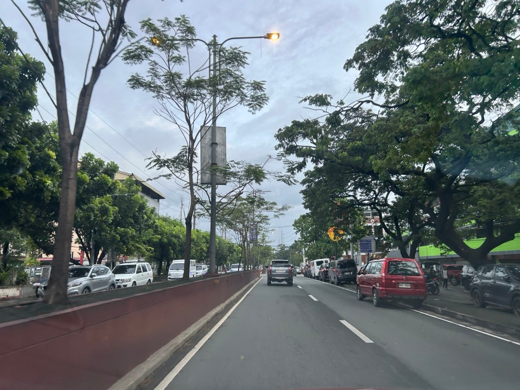
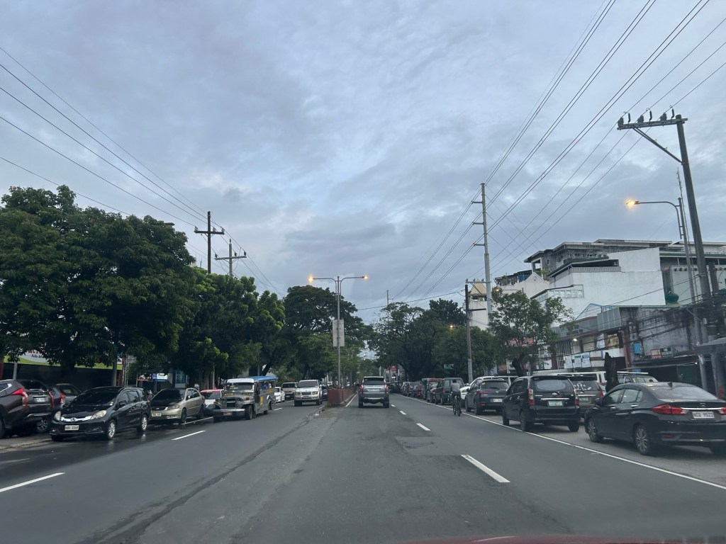
Car-centric discussions aside, when you go the ‘east’ you will notice a lot of people using SUVs. One reason probably is because many Rizal towns including Antipolo City, and Pasig and Marikina Cities are prone to flooding. Can you imagine over 50 years of flooding in these areas? And then with the current investigations concerning flood control projects, have you wondered if the ‘east’ really got their taxpayers’ money’s worth in terms of interventions?
–
Our clear and present problem with DPWH and certain contractors
I was going to write about the new taxi service and TNVS I used recently during this long weekend. Unfortunately, I lost focus and “gana” after reading about the collusion among DPWH officials and certain contractors about flood control projects. Here are my sentiments today that I shared on my social media account:
“Bakit walang pasok bukas? Kasi may nagbabadyang masamang panahon. Baka bumaha? Bakit babaha? Alam na siguro natin ang sagot sa tanong na ito? Damay-damay na yan. Resilience na lang ba ng mga taong nagbabayad ng buwis ang kasagutan? Di ba dapat may managot sa kung bakit patuloy tayong binabaha samantalang bilyones o trilyones ng kaban ng bayan ang ginagastos? Naiisip ba natin na yung pinagpaguran, pinagpapaguran at pagpapaguran natin ay napupunta sa mga nanlalamang? Wala nga siguro silang nararamdaman at napapansin habang nakasakay sa kabilang magagarang sasakyan. Tayo naman, hanggang tiis sa paglusong sa baha at mag ‘abangers’ sa anunsyo ng walang pasok.”
With the recent revelations of these contractors having the propensity to purchase luxury items like expensive vehicles, do we still wonder why these people cannot feel what ordinary people experience during these times of inclement weather? Hindi nga siguro maramdaman ang baha o ang mga lubak sa daan pag naka SUV ka. To be quite direct about this, I would like to personally drag them to experience the floods and maybe submerge their homes for a few days so we’re even. I am probably not alone with my sentiments.
Flood control is probably just the tip of the proverbial iceberg. There are just so many other projects including roads and bridges that also need to be investigated for anomalies. Will the current administration act on this? Or are we just being taken for a ride with all these lip service and grandstanding by politicians and government officials?
–
On the impact of more frequent lightning strikes on airports
We were waiting for our plane to arrive at the airport yesterday and can’t help but observe the heavy rains falling while a strong wind blows and causes the rains to fall at an angle. This renders umbrellas to be ineffective in keeping you dry if you’re outdoors. Such weather requires a long coat or even overalls to keep one dry on a very wet day. The rains and wind were brought about by a storm affecting the area. Though distant, the storm was able to influence the weather. Fortunately, there wasn’t any lightning and we wondered if lightning strikes have affected ground crew working in an open area that makes them vulnerable to lightning strikes. Here is an interesting article that describes the threat of lightning strikes particularly to people on the ground at airports.
King, R.E. (September 11, 2024) “Increasing Lightning Strikes from Stronger Storms Could Cripple Airports and Airbases,” Jalopnik, https://jalopnik.com/increasing-lightning-strikes-from-stronger-storms-could-1851645799 [Last accessed: 9/16/2024]
Quoting from the article:
“While flying planes are hardened to withstand lightning strikes, airports are typically a cluster of free-standing structures on a flat, open plot of land. The ongoing increase in lightning strikes caused by climate change is a direct danger to facilities and people on the ground.”
I wonder about similar data or statistics in the Philippines considering the long wet season we have that includes not just threats from typhoons but from seemingly small weather systems that may involve lightning strikes. I recall operations at NAIA were halted a few times when there were lightning storms. Is this phenomena. I wonder how many incidents at our airports have been reported and recorded pertaining to lightning.
–
Technical sessions at the TSSP 2024 Conference
I am sharing here the latest draft of the technical sessions for the 30th Annual Conference of the Transportation Science Society of the Philippines (TSSP). The conference will be held in Iloilo City this coming September 13, 2024.
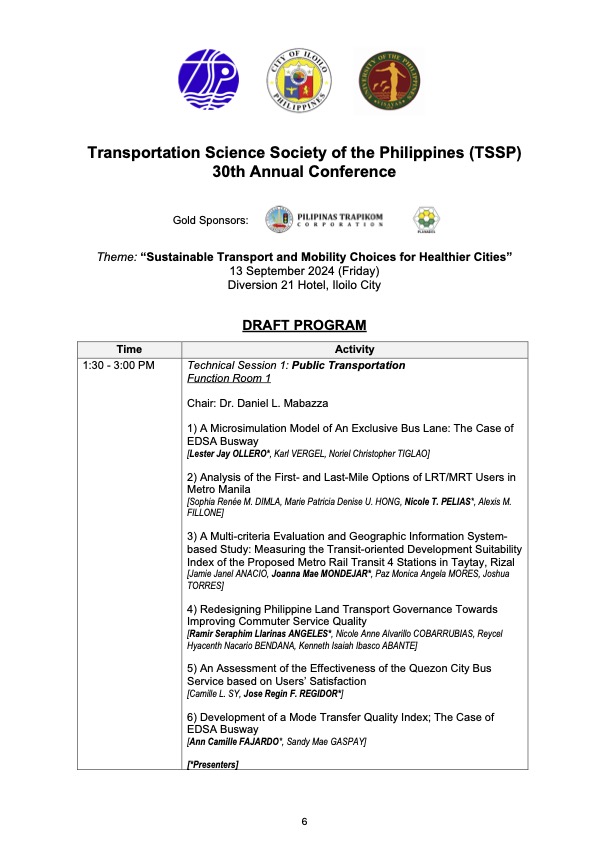
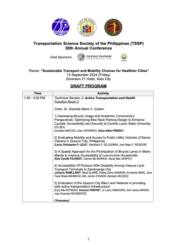
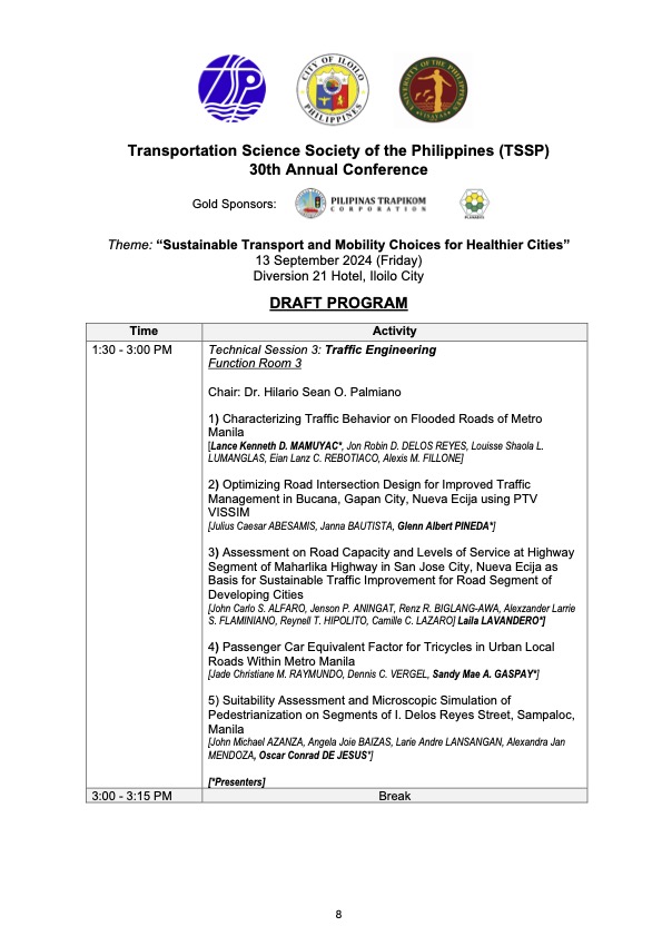
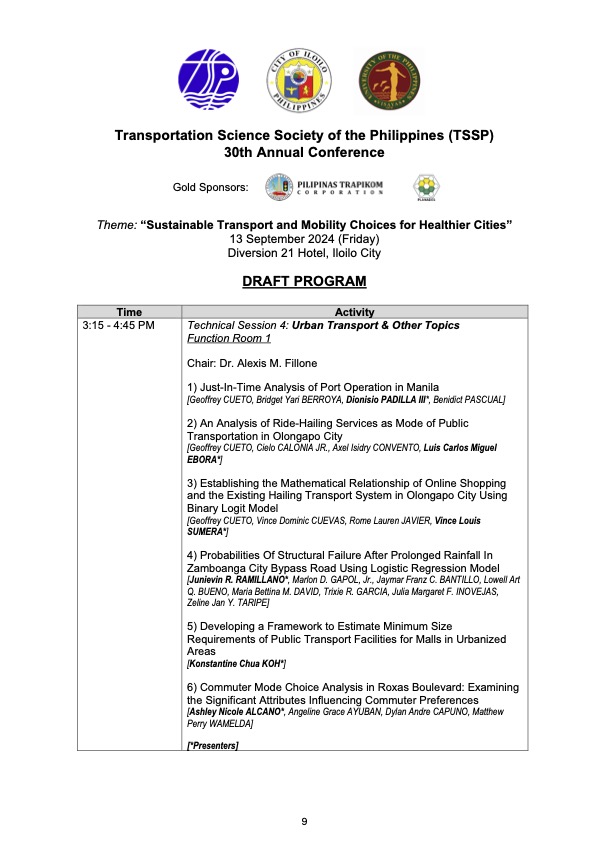
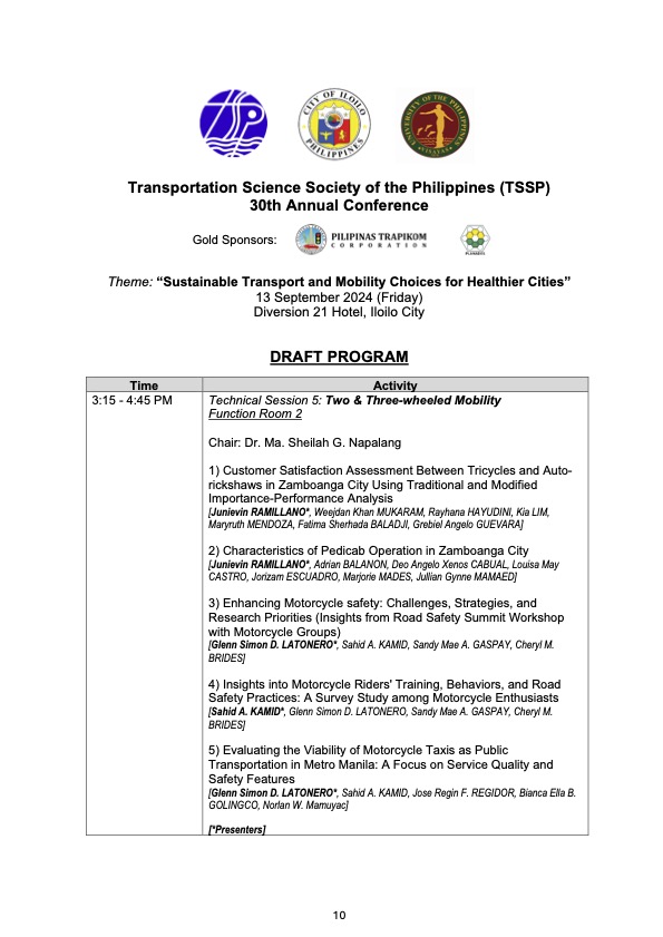
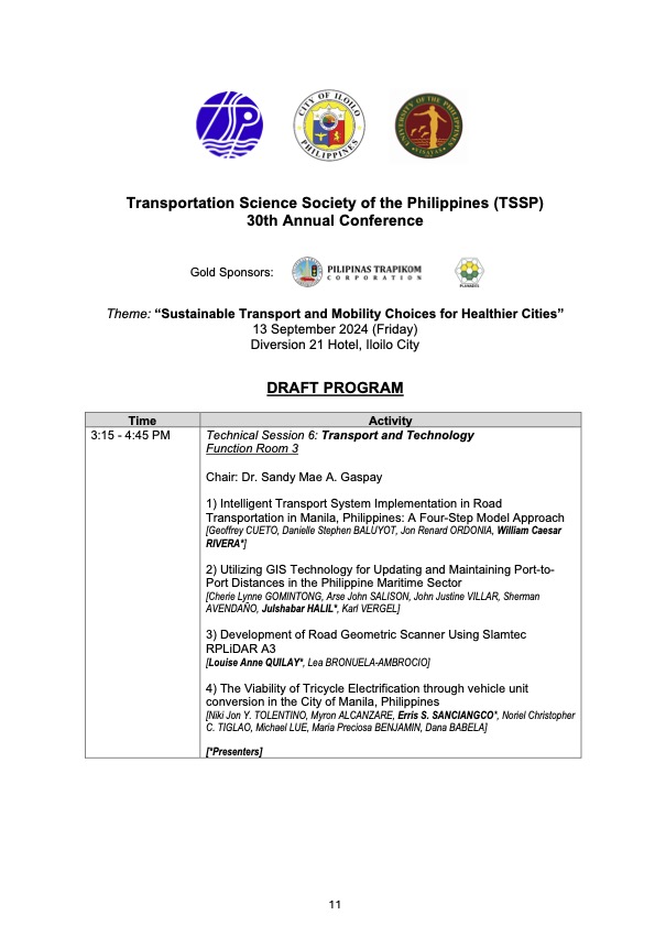
I will share the draft program for the morning plenary session in the next post.
–
On trees as solution to many of our urban problems
I am sharing this nice article on trees being the solution to many of our urban problems. I think many people have come to notice the importance of trees and the role they play with the increasing temperatures (i.e., heat) we’ve experienced the past years. The science on this state much more and covers not just temperatures but flooding, energy and infrastructure as well. Discussions and examples on these are in the article:
Durand-Wood, E. (August 8, 2024) “The Multi-Tasking Marvel: How Street Trees Can Solve Many Municipal Problems,” Strong Towns, https://www.strongtowns.org/journal/2024/8/8/the-multitasking-marvel-how-street-trees-can-solve-many-municipal-problems [Last accessed: 8/28/2024]
To quote from the article:
“Planting and maintaining street trees is an investment, but it’s one that pays for itself over and over again. Cities around the world are starting to calculate the economic value of their urban forests, a task made feasible with tools like i-Tree.
And more research is finding that trees pay for themselves many times over. A U.S. Forest Service study “conducted in five U.S. cities found that every dollar invested in the management of urban trees [ …] yields annual benefits of $1.37 to $3.09.
Trees are also the perfect example of a small bet. They cost relatively little, but the many varied returns are so high.”
–
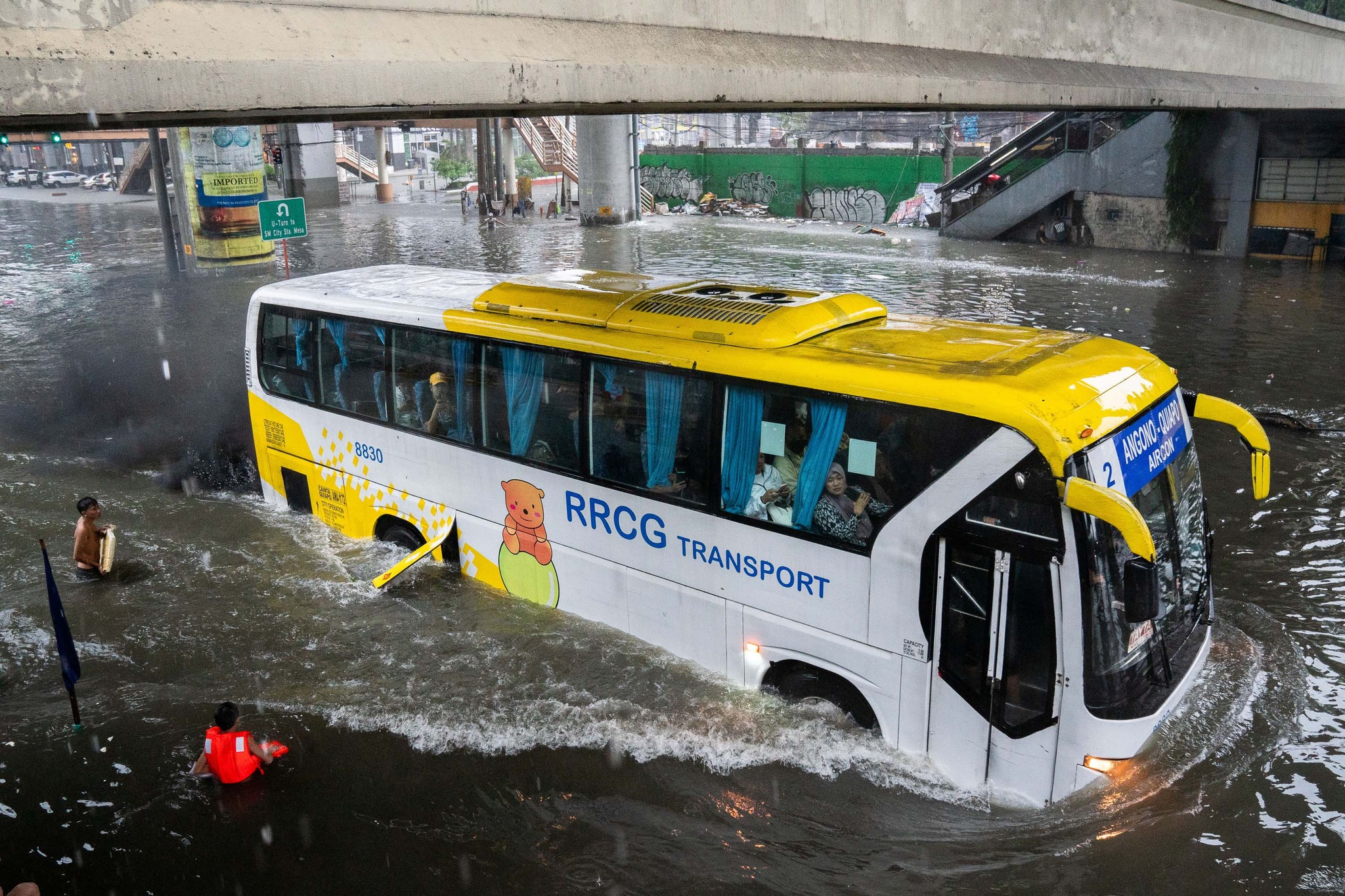
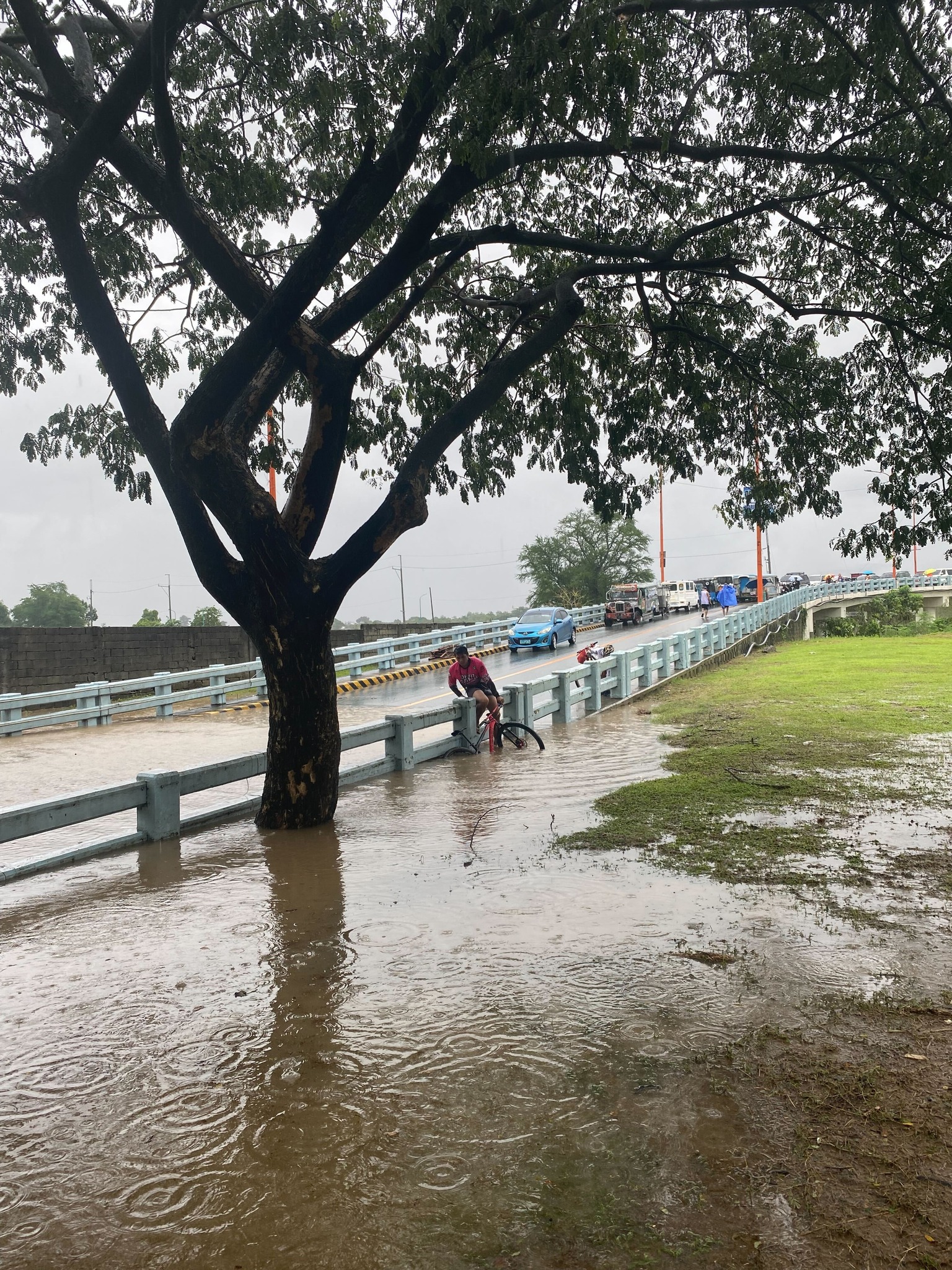
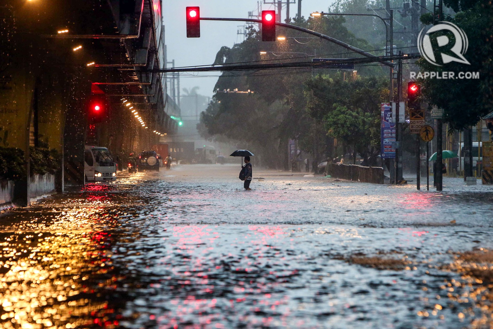
On transportation and floods
Some people say transport and traffic concerns take a backseat to floods and related concerns, which affect other aspects of our lives aside from our commutes. The heavy rains the past days have rendered many streets impassable to most types of vehicles. That means people cannot go to work, school or come home. Lives are disrupted by floods this way. But even more disruptive and disastrous are the damages brought about by flooding in many communities. Homes are submerged. Properties are damaged, many beyond repair or replacement. There is also the psychological aspect of floods especially for those who will experience them for the first time. These will surely add to the already fragile mental health of people still reeling from the effects of the COVID-19 pandemic.
As I write, the Marikina River has breached and many areas of Metro Manila and surrounding provinces of Bulacan, Rizal, Laguna and Cavite are flooded. The floods are now being mentioned along with those brought about by Ondoy (Ketsana) in 2009.
Here are some photos from the internet being shared by various social media accounts including the official pages of Rappler and Inquirer:
–
Extreme turbulence during air travel
Transport-related news last week included a report about a Singapore Airlines B777 jet flying to London from Singapore that had to make an emergency landing in Bangkok due to extreme turbulence experienced. Many people were seriously injured when the plane suddenly ascended (“tilted up” as some news reports state) and then abruptly descended, resulting in people being tossed up and hitting the compartments above their seats. Obviously, these passengers were not wearing their seatbelts at the time. Otherwise, they would have been restrained to their seats. It is likely that the turbulence was not anticipated by the pilot as they usually advise passengers to put on their seat belts if turbulence was expected at any time during a flight.
The incident raises concerns about extreme and sudden turbulence occurring during flights. I guess this may happen anytime and aircraft instruments may not be able to tell the crew about an impending incident like this. Will such an incident have a significant impact on air travel? Perhaps not if these incidents remain rare. There should be records and monitoring of factors or elements leading to such incidents in order to establish the likelihood of these happening. Incident records will also show if there is an increasing frequency as well as the number of people killed and injured. Such information would be vital as more people use aviation for travel and there are more aircraft activity around the world.
As a precaution, it is good practice not to remove your seatbelt while seated in flight. If it’s tight, then loosen it. At least you have some restraint in case of incidents where the aircraft encounters sudden turbulence.
–
Article share: on the collapse of a bridge in Baltimore
The recent incident of a container ship colliding with the bridge in Baltimore in the US has been trending and gone viral. There are also many articles now putting out their assessments of what happened, how the bridge collapsed, what troubled the ship, etc. There are also now articles discussing the implications or the impacts of this incident on logistics considering the collapsed bridge lies along a busy maritime route in the US. Here is an article that focuses on the former, providing analysis on how the ship caused the collapse of a major bridge.
Laris, M. Hassan, J. and Achenbach, J. (March 26, 2024) “How a cargo ship took down Baltimore’s Key Bridge,” The Washington Post, https://www.washingtonpost.com/dc-md-va/2024/03/26/how-key-bridge-collapsed-baltimore/ [Last accessed: 3/27/2024]
What also came to mind as I read reports about this incident is something similar that could happen to the CCLEX bridge connecting Cebu and Mactan Islands. Apparently, something similar already happened decades ago when a bulk carrier, Sanko Elegance, collided with the pier of the first Mactan Bridge. While the bridge did not collapse, it sustained damage that required it to be repaired and severely affected traffic between the two islands considering it was the only bridge at the time. It is important to note that the airport was on Mactan Island so it affected both passenger and freight flow for the province and others that connect and trade with it. While a former student who was much involved in the construction of the CCLEX bridge assured us in a briefing before that the bridge pier can withstand the collision of large vessels (perhaps the largest currently calling on Cebu ports), there may be larger and heavier ships in the future. The Key Bridge, after all, was hit by a container carrier that was larger than the ships transiting in the area when the bridge was designed and constructed.
–
Article share – on aircraft evacuations and the case of JL516
Here is a very informative article on aircraft emergency evacuations, particularly the case of the recent JAL 516 where all passengers and crew were able to evacuate the burning aircraft.
Tamura, Y. (January 7, 2024) “Why the Evacuation of 379 Passengers from the Burning JAL516 Wasn’t a Miracle,” Medium, https://medium.com/japonica-publication/why-the-evacuation-of-379-passengers-from-the-jal-collision-wasnt-a-miracle-8a03cb02a95c [Last accessed: 3/4/2024]
To quote from the article:
“Japan is said to have become earthquake-resilient over the decades, but it’s less known that the same applies to aircraft accidents.
As the oldest Japanese airline company partially founded by the government in 1951, the history of JAL encapsulates the narrative of Japan’s aviation industry, punctuated by significant accidents.
It is none other than JAL that experienced the worst-ever airplane crash in the world. In 1985, JAL123 crashed into a mountain approximately 100 km from Tokyo.
The crash, believed to have been triggered by improper maintenance of the aft pressure bulkhead, caused 520 fatalities, the largest loss of life in a single aircraft.A former JAL employee comments that those who have survived traumatic incidents often grapple with returning to their duties in the sky. Despite this difficulty, they also carry a deep sense of responsibility to impart their experiences to younger crew members, contributing to the commitment to safety.
I agree that the successful evacuation was not a miracle but a product of the training and dedication of the staff as well as the culture and behavior that was very obviously Japanese. One wonders what could have happened if this were, say, an airliner from a third world country? Or perhaps even one from a country like the US? Would the evacuation have been successful like JL516’s?
–
