
Home » Highways and Streets (Page 15)
Category Archives: Highways and Streets
Traffic congestion along Sen. L. Sumulong Memorial Circle
I was on some errands and had to pass through the Sen. Lorenzo Sumulong Memorial Circle from Taktak to the other side of Antipolo near the Lico Circle. The section from Robinsons Antipolo where the Sumulong Circle intersects with Sumulong Highway until C. Lawis Street is being widened and photo below shows the work in progress. The road is a dangerous one especially at night. There are a lot of electric poles in the middle of the newly constructed lanes and power and phone lines dangling in many places. The unfinished parts have a lot of excavations, construction material and debris from the demolished buildings.
 Widened section of Sen. L. Sumulong Memorial Circle
I took the following photos while traffic was at a standstill:
 Initially, it was not so obvious what the cause of congestion was except for the dramatic sag along the road. Both sides appeared to be congested.
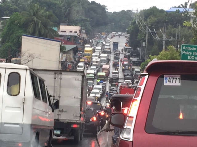 Closer observation showed my direction to be congested up to a certain point whereas the opposite direction across from me was free flowing and traffic build-up along the other side also appeared to be from a certain location at the bottom part of the sag.
It turned out that out of the 6 lanes of the road, only 3 lanes were available to moving traffic – one lane along my way and two along the opposite. Vehicles were parked along 2 lanes of the road in front of the Antipolo City Police Station and 1 lanes across from it. It seems quite ironic considering the police is also tasked with traffic enforcement and management and yet the problem emanated from their station. I am not sure whose vehicles are those that are parked along the road. Perhaps many are owned by police officers? By comparison, the national high school beside the station and the nearby hall of justice did not seem to generate as much vehicular parking as the station. The obvious solution though would be to have an off-street parking lot or facility. Looking at Google Maps, there are some locations along M. Santos Street where a multi-level parking facility can be built but land needs to be acquired first and that can be a difficult task. Another option might be to relocate the main station (i.e., headquarters) elsewhere where there is space for proper facilities including off-street parking. Perhaps they should have a place at the new government center being developed by Antipolo?
–
Why do we need to reduce speeds?
A common observation made of Philippine drivers is that they seem to hesitate from slowing down even at hazardous locations or situations. Note, for example, vehicles approaching an intersection and you will observe that many if not most will not reduce their speeds. Most guilty for me are motorcycle riders who tend to maneuver and even speed up instead of slowing down for a safer approach. Slowing down (i.e., reducing one’s vehicle’s speed) is actually a no-brainer and something that is explicit in any country’s traffic rules and regulations and driver’s handbook.
I saw a lecture on why reducing speeds are important. This is not just from the specific perspective of safety but is explained in favor of mobility and quality of life. Here’s the lecture:
Reducing speeds for better mobility and quality of life by CarlosFelipe Pardo
–
Some issues at Barkadahan Bridge
Perhaps one of the worst places to be in terms of traffic during the morning peak is Highway 2000, and particularly the approach to the Barkadahan Bridge that crosses the Manggahan Floodway. Traffic management at the intersection of the East Bank Road and Highway 2000 is so atrocious that everyone passing the junction would likely incur delays of more than 30 minutes.
The congestion in the area is also attributable to the fact that you have major roads carrying traffic from all over the eastern town of Rizal that are bound for Makati and Taguig (Bonifacio Global City), mostly for offices in those CBDs. These commuters likely use the completed C-6 sections including those at Lupang Arena and the expansion along the Laguna de Bay coast.
 Barkadahan Bridge is a 2-lane structure with significant local traffic such as the tricycles in the photos
 On either side are narrow walkways and it no uncommon for people to walk on the carriageway itself .
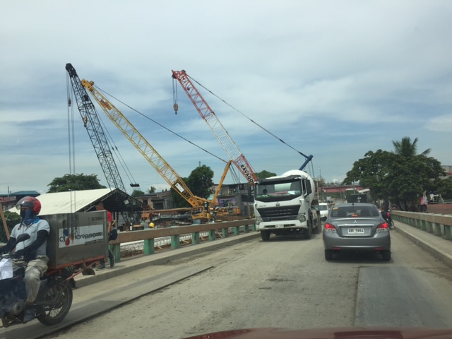 The bridge’s expansion is underway but, from my observation, is taking too much time. Perhaps the contractor is having problems with the foundations for the posts? Or maybe the funds aren’t flowing as required for the effective implementation of the project?
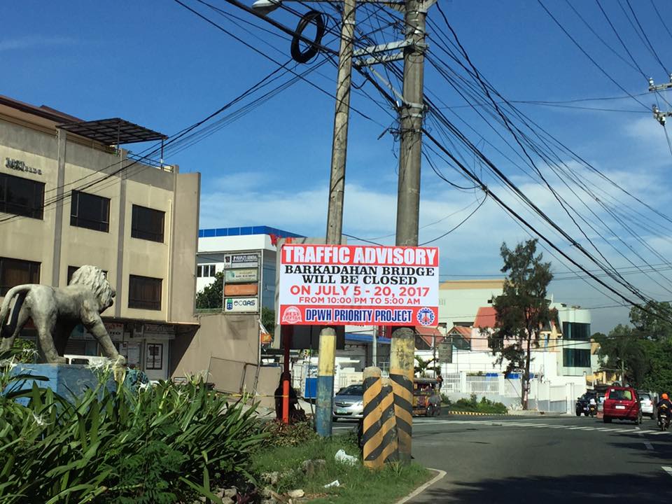 This is an ‘old’ sign now as July 20 is already more than a week ago.
A lot of people look forward to the completion of the bridge but the bigger issue is still the traffic management at the intersection that is also influenced by factors such as the tricycle terminal near the junction and the undisciplined local traffic. The situation is exacerbated by those who counter flow along Highway 2000 and generally get away with it. Perhaps the Municipality of Taytay should get some help in improving their capabilities for traffic management?
–
More major traffic generators along Ortigas Ave. Extension?
There’s another mall being constructed along the westbound side of Ortigas Avenue Extension just before the Lucky Gold Plaza and across from the One Oasis residential enclave. That area is already very congested as will be attested to by the thousands who pass this way especially during the morning rush. Here’s a photo of the mall that is currently under construction as seen from the bridge crossing the Manggahan Floodway. The steel frame on the left and behind the pedestrian bridge is the mall’s.
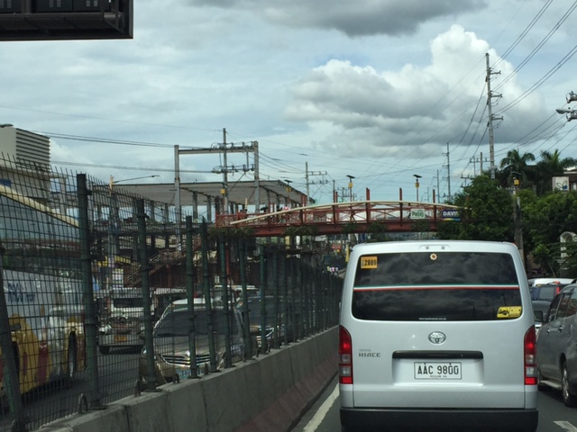 That’s another mall being built across the Bali Oasis near the Manggahan Floodway
Among the future major traffic generators that will likely make traffic congestion along Ortigas Avenue worse are the following:
- Residential development across Countryside subdivision
- Town center development near Valley Golf
Commuters using this corridor will likely find traffic worsen (could it really get worse than what it is now?) and traffic schemes by the LGUs along the corridor (i.e., Pasig, Cainta and Taytay) will not be enough to alleviate traffic over the medium to long term. Only a dedicated mass transit line can provide significant improvements for travel along this corridor.
I am still wondering about the mass transit solution for this corridor. There are arguably more people traveling along Ortigas Avenue compared to Marcos Highway that already has Line 2 under construction. I’m sure if you asked people when a mass transit line’s needed along Ortigas, they will reply “years ago”. Being one who has traveled along this corridor since the 1970s (I was a resident of Cainta and then of Antipolo), I can say that traffic indeed has worsened over the last 3 decades. Travel demand management (TDM) measures such as number coding and transport systems management (TSM) schemes such as Pasig’s one-way scheme will not be enough to address the growth along the corridor as they were and are not enough in the first place.
–
On the transportation aspects of Antipolo’s pitch for the senate to relocate there
I was browsing Facebook the other day and found an interesting post by the Antipolo City Government’s official account. They posted about the presentation made by the current mayor to the staff of the Philippine Senate, selling the idea for the Senate to relocate from its current location in Pasay City. There are currently two options known to us: Fort Bonifacio in Taguig City and Antipolo City in Rizal Province.
The Antipolo government’s post stated that it only takes 25 minutes between the the Batasan Complex and the proposed site, which is on land owned by the Antipolo City Government. This was probably based on travel time estimate using a tool such as Open Street Map. This though is inaccurate since travel times are affected by various factors and will vary according to time of day, day of the week and even month.
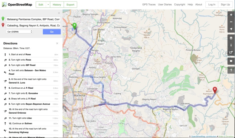 Open Street Map visualization of travel route and time between Batasan Complex and the proposed site for the Senate
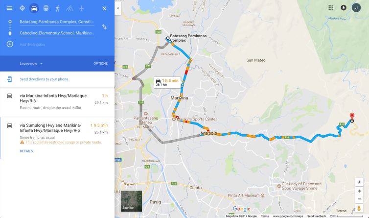 Google Maps visualization of alternative routes and typical travel times
I took the preceding screen captures at 10:00 AM on June 23, 2017 (Friday). Open Street Map’s version can be misleading because it states a travel time assuming practically no traffic (~26 km in 27 minutes or about 58 km/hr in terms of travel speed). Google Maps version is better as it accounts for typical traffic during a certain time of travel (i.e., 10AM). Thus, there’s the more realistic 1 hour travel time for the same distance (about 26 km/hr travel speed). Google’s is based on crowdsourced data and can be customized based on the day and time of travel (e.g., 8:00 AM on a Monday). And I wouldn’t even want to get into the discussion of the accuracy of the claimed 40-45 minutes to/from the airport (i.e., NAIA). Again, anyone with Waze or Google Maps can get more realistic travel time estimates for such trips.
What would be the transport impacts of such a relocation. For one, employees of the Senate (and I am not even considering the Senators and their closest staff here) would have to travel from their residences to the proposed site in Cabading, Antipolo City. Where do these staff live? If they were from Manila and they take public transport, that probably means they would have to take the LRT Line 2 to Masinag and then take a jeepney from Masinag to the site. Line 2 would present the most efficient option in terms of travel time and cost compared to taking a jeepney or van via Cubao. I am not aware of any direct transport services for them although we can speculate that perhaps new routes can be established. The Senate has shuttle buses so these would also be an option for those taking public transport. Car owners will have to travel and converge along Marcos Highway. It is uncertain when the extension to Cogeo will be decided and constructed, if at all.
There is also mention of the plans for Circumferential Road 6 (C-6). However, the reality is that government is taking its time in upgrading the existing sections in Taguig, Pasig and Taytay. The Taguig sections are in a very bad state now after the onset of the wet season. Dealing with the ROW acquisitions necessary for planned C-6 sections is already a big challenge as the areas are already built up or developed (mostly residential subdivisions).
Having the Senate complex in Antipolo will have repercussions on land use/development as well as land prices and rent. It will be located at a relatively undeveloped part of the city and will likely encourage urbanization there. Antipolo should be careful in regulating land development so that the area will not become another Batasan with all the informal settlements and the low density developments around it. There are many opportunities here to develop the area into a showcase government center and that should include planned development for residential, commercial and institutional uses. The housing options should include affordable walk-up apartments as well as medium rise buildings like those by DMCI and Filinvest. It is important to emphasize that options for affordable housing near the workplace cannot be provided in Fort Bonifacio since land and residential unit prices there are already very expensive; forcing most Senate staff to live outside and away from their offices. Such a situation necessitates long commutes and contributes to congestion.
To be fair, there is a good potential for congestion reduction if the Senate relocates to Antipolo. Perhaps the concept of a “New Town” in the proposed site can be developed in more detail. But questions arise: Will this attract major schools, for example, as well as offices such as BPOs? What is definite is that Antipolo will not be the only LGU that will benefit (economically) here but perhaps much of the Province of Rizal, too, as well as the nearby cities of Marikina and Pasig.
Decongestion can happen if:
a) Senate staff decide to move to Antipolo and environs (e.g., Marikina, Cainta, Tanay, etc.).
b) A significant number of staff reside at the proposed dormitories during much of the weekdays, and go home only for the weekends and holidays.
c) Efficient public transport is provided for them and Antipolo constituents along the corridor to be served.
d) Sustainable transport facilities like walkways and bikeways be developed to reduce dependence on motorized transport especially for short distance travel.
In the end, though, I think it will be the Senators who will be making the decision on this matter. Will they be more practical, pragmatic, or insensitive to the consideration of their staffs? Abangan!
–
Some updates on C-6
I have not used Circumferential Road 6 in a while. And so a couple of weeks ago, I was happy to see that work has resumed on the sections at Lupang Arenda in Taytay, Rizal, which is also known as Sampaguita Street. Here are some photos of the wide C-6 section. I guess there’s an opportunity here to have service roads on either side of the highway in order to manage/control local traffic. C-6, after all, is a highway and is designed for typical national highway speeds (i.e., 60 kph). The adjacent land use, however, requires slower traffic mainly due to safety concerns.
 Cordoned-off section where a contractor is preparing the sub-base prior to placing the steel reinforcement and pouring concrete
 Another photo of the section showing form works for the slab. Note the parked vehicles along the side on the left.
 Some sections are already flooded from the heavy rains
 The completed section towards Nagpayong, Pasig is a wide 4 lanes. At left is a nice view of the Laguna de Bai.
 Section to Nagpayong near the boundary of Taytay, Rizal and Pasig City.
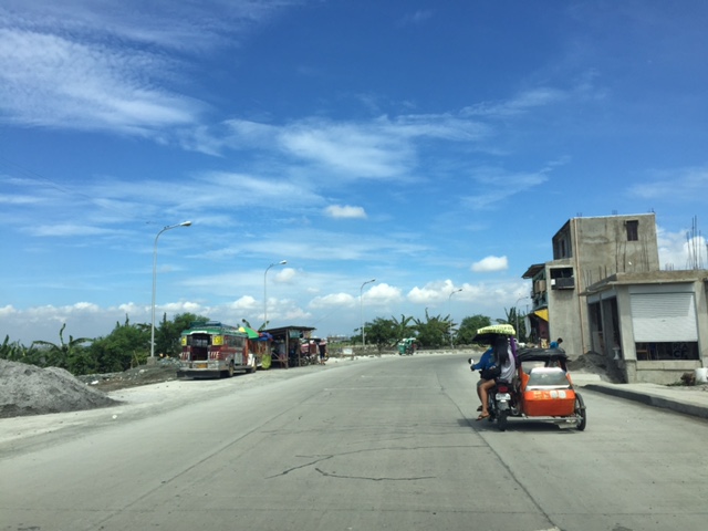 That’s a habal-habal (motorcycle taxi) terminal on the left and in front of a parked jeepney.
Two very important things about C-6 though. One concerns the Barkadahan Bridge over the Manggahan Floodway, which is too narrow for the traffic that cross it. There’s a new bridge beside it that seems to be taking too long to build. And then there’s the long stretch from Nagpayong, Pasig to Lower Bicutan, Taguig which remain in bad condition. The new section along the lakeside is already usable for Pasig-bound traffic but needs to be allowed to carry two-way traffic for the older section to be rehabilitated. C-6 is becoming a major alternative route for a lot of travelers from Rizal to and from Makati and Taguig (esp. BGC). It needs to be improved immediately as it can help decongest the Ortigas Ave. – C5 route that most Rizalenos use to go to their workplaces.
–
Newly opened sections of C-6
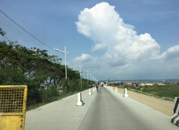
I have been wanting to post these photos of the newer sections of Circumferential Road 6. The section was constructed months ago and is part of a project that seeks to widen the current stretch of C-6 from Taguig (Lower Bicutan) to Pasig (Napindan) from the old 2-lane, 2-way road into a 4-lane, divided road. The new section opened to general traffic along the southbound side (to Taytay) and has improved traffic along the section that’s provided people from Rizal an alternative route to Makati and BGC through Taguig. Only, light vehicles are allowed along the new section and trucks and other heavy vehicles take the old road, which is quite battered by the traffic. Only one lane is currently available as there are barriers along the section as shown in the following photos. Traveling along the section also afford people a nice view of the Laguna de Bay to the right.




–
“Great wall” of trucks along C5
The Metro Manila Development Authority (MMDA) has implemented a truck lane policy along Circumferential Road 5 during the last administration. It has continued at present and a long line of trucks are regularly observed along C-5 whenever the truck ban is lifted during what is designated as off-peak hours for all other traffic. Many travelers have termed the line as a “Great Wall of trucks” although in many instances, the line is “breached” by vehicles needing to shift lanes along this major thoroughfare. Strict implementation by the MMDA and the affected LGUs as well as the compliance of most trucks have led to the maximization of the occupancy of the designated truck lanes. These are easily observable along most of C-5 and particularly along sections close to the CBDs (e.g., BGC, Ortigas, Eastwood, etc.). Following are a few photos showing the long line of trucks along C-5:


Here’s another photo I took earlier last month:

We have a couple of students now at UP Diliman who are studying the policy and taking a look at the traffic and pavement conditions along C-5. Interesting would be their comparisons of traffic along the truck and non-truck lanes during both peak and off-peak periods as well as for weekdays and weekends. Interesting, too, will be their assessment of pavement conditions. So this will be something to look forward to once the research is completed this coming May 2017.
–
The Tagaytay transportation predicament
The title of this article is actually a bit tame and on the diplomatic side of trying to describe transportation and traffic in this city that was once relaxed a retreat for many. I had wanted to end February on a good note and so I decided to defer posting this until March.
We used to frequent Tagaytay and liked spending some rest and recreation time there to the tune of being there almost once a month at one time. Needless to say, at the time travel to Tagaytay from our home in Antipolo took us only about 2 to 2.5 hours excluding our usual stop at Paseo in Sta. Rosa, Laguna. We liked the city so much that we even considered making it a second home; even inquiring and looking at properties there.
Fast forward to the present and it has become an excruciating travel with the highways leading to the city already congested. It didn’t help that when you got there, you also had to deal with serious traffic congestion. This started not a few years ago when the city approved developments by major players including Robinsons, SM and Ayala. The developments by SM and Ayala proved to be the backbreakers with Ayala coming up with the first mall in the city and SM operating an amusement park beside its prime acquisition that is the Taal Vista Hotel. Now, there is another mall under construction by Filinvest and right at the corner of the rotonda where the Aguinaldo Highway terminates.
 Vehicles queue along the Tagaytay – Nasugbu Highway towards the Rotonda where Tagaytay traffic enforcers attempt to manage traffic but appear to create more congestion instead.
More on Tagaytay soon…
–
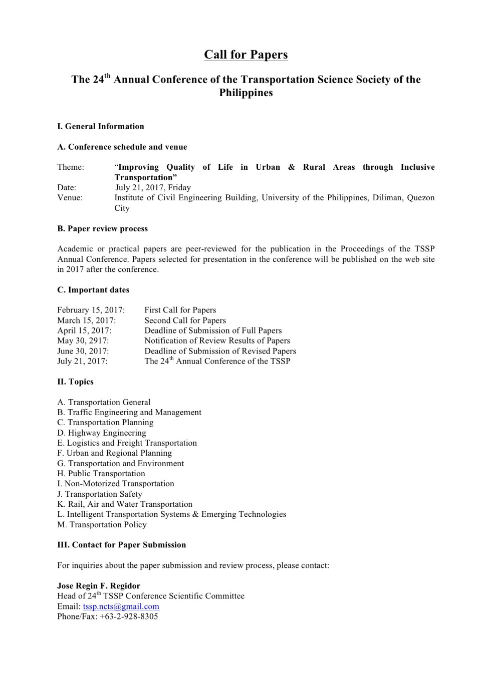
First call for papers for the TSSP 2017 conference
The first call for papers for the 24th Annual Conference of the Transportation Science Society of the Philippines came out last Wednesday, Feb. 15:
–
 Caught (up) in traffic