
Home » Infrastructure (Page 24)
Category Archives: Infrastructure
Community road works
There have been a lot of roadworks recently at the subdivision where we reside. This is a good thing for the residents as many roads have deteriorated after so many years of non-maintenance. The rehabilitation of the main roads, I understand, were and are funded by public money through the City Government and the DPWH. This is made possible by the subdivision’s roads being already turned over to the city government and with the subdivision being also a barangay. In fact, the subdivision is the smallest of the city. Following are some photos of roadworks in our village.
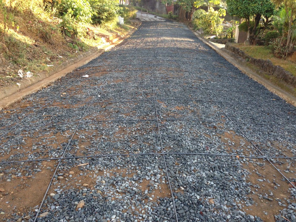 Base layer and steel reinforcement
 A close-up of the “ties that bind” the steel bars together
 Section for concreting
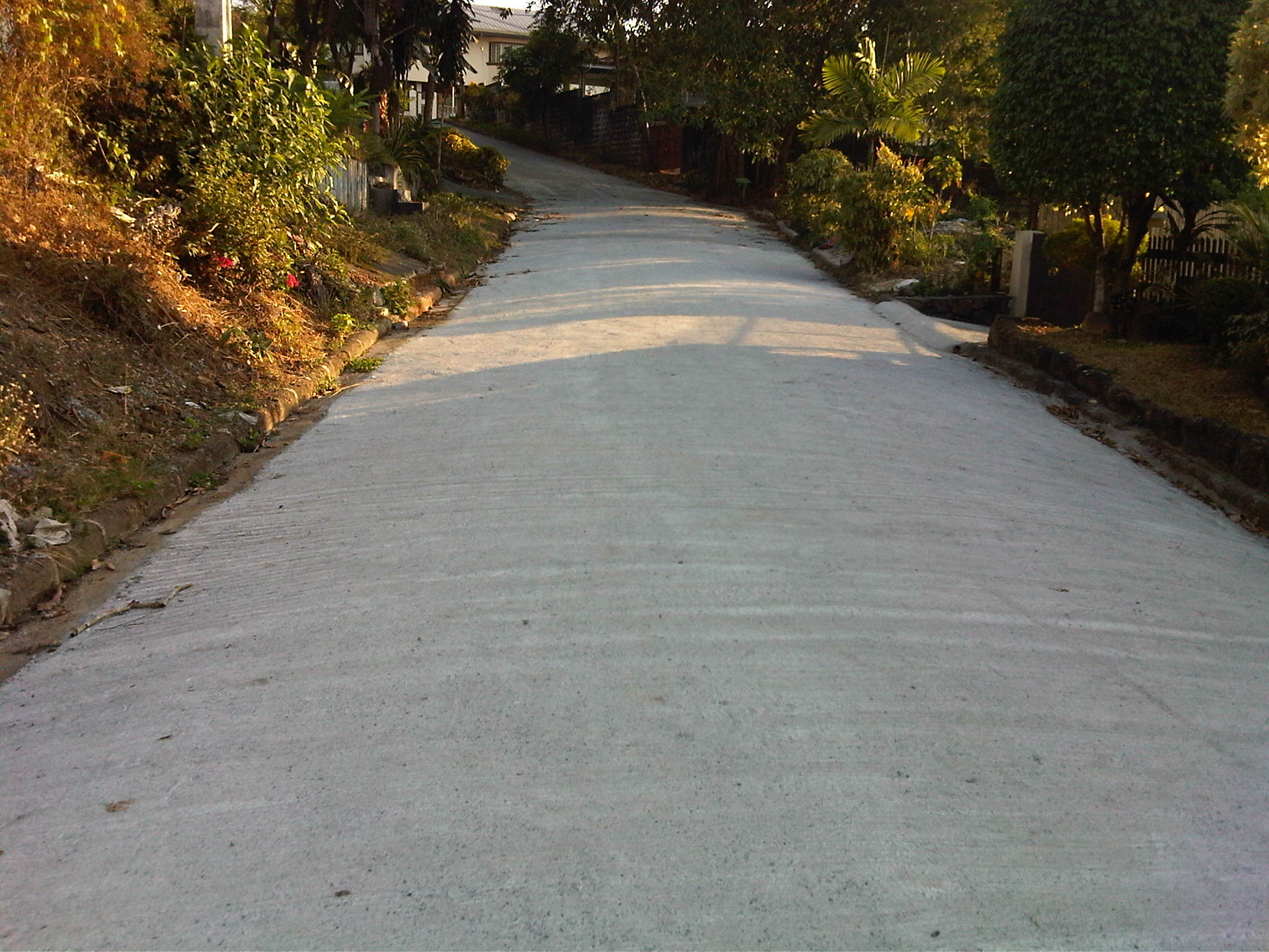 The finished product
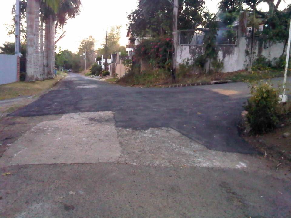 Asphalted pavement at an intersection near the homeowners’ association office
We are very appreciative of the efforts of our village homeowners association in improving the infrastructure in the subdivision. The current policy calls for the prioritization of road sections where residents are up to date in paying their dues. I think this is a fair approach to prioritizing community road works. In fact, there are more road works being implemented now. This is good timing considering it is the dry season. The only drawbacks of such projects are temporary road closures and re-routing of traffic.
–
End game: flyover frenzy
The Manila Bulletin featured news on the Japanese government extending a loan to the Philippines for road projects in Metro Manila that include the construction of several major interchanges. An excerpt from the article is as follows:
The Japanese government will be providing some P4 billion to the Philippines for road projects aimed at decongesting monstrous traffic jams in Metro Manila.
Noriaki Niwa, chief representative of the Japan International Cooperation Agency (JICA), said the loan will cover major interchanges to address traffic congestion in Metro Manila, including flyovers, and road links.
Among them are the interchanges on EDSA/Roosevelt/Congressional, EDSA/West/North, and C-5/Green Meadows and North/Mindanao Avenue.
“This is to help Metro Manila sustain growth and develop it as an attractive investment destination,” said Niwa.
While these interchanges have been recommended many years ago and are also reiterated in the recent transport roadmap for Mega Manila, one cannot help but make the observation that these projects will not alleviate congestion over the long term. Instead, it will likely encourage more vehicle traffic (with the availability of more road space – part of a vicious cycle).
Other major projects that are ongoing in Metro Manila include the NAIA Expressway, which is an elevated tollway connecting to the Skyway. A friend commented that this is basically a glorified flyover project as I will explain later in this post.
 NAIA Expressway construction in full swing – a column rises near NAIA Terminal 3
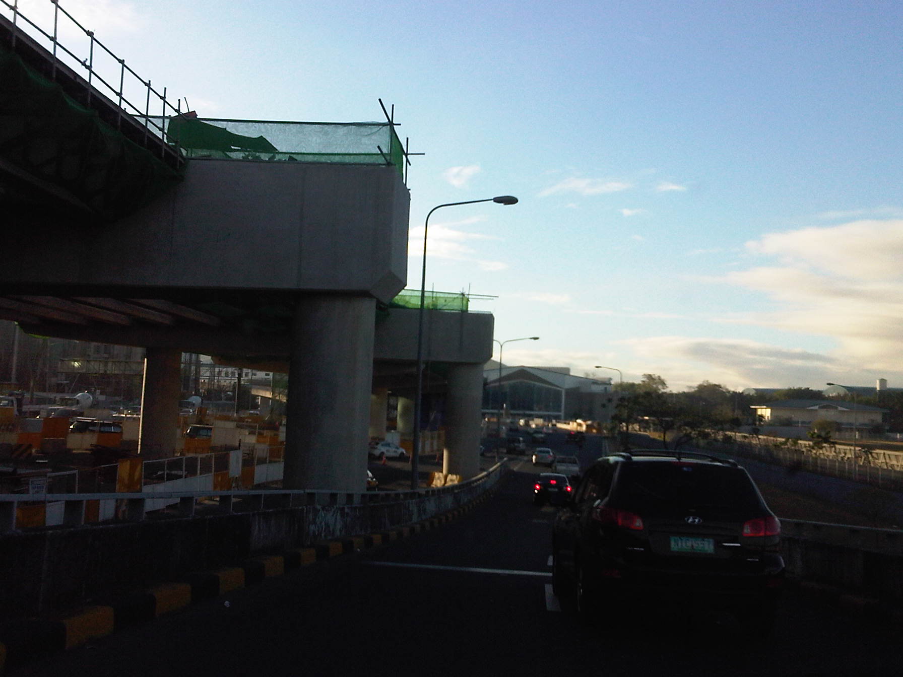 NAIA Expressway elevated sections nearing completion across from Terminal 3
The term of the current administration concludes next year (2016) and so we are almost in the endgame, to borrow a term from chess. What seems to be a frantic move for the government to build all these flyovers (and elevated tollways) can be interpreted as a way to compensate for the underspending and underachieving ways of the government in putting up the necessary infrastructure to address transport and traffic problems in urban areas. Unfortunately, all the funding (public and private) seems to be going to road projects instead of to mass public transport systems like rail and BRT that should be the priority because these could provide the positive impacts over a longer term than what road projects could deliver in terms of mobility and sustainability.
A friend reminded me of a similar situation back in 1991/92 when government embarked on a slew of flyover projects in an effort to leave a legacy in transport. That administration’s excuse for failing to deliver any mass transit project was that it was transitioning from a dictatorship. However, it also failed to deliver on power projects, which led to the energy crisis that had to be solved quickly (but with costly PPP power plant projects). There is a looming energy crisis now but more worrying is a transport crisis as we continue to procrastinate about public transport infrastructure. Should we be hopeful of transport with the next administration? That is still a big question as of now.
–
If you build it, will they come?
There seems to be a belief among the more zealous advocates of sustainable transport that if “you build it, they will come.” It seems cliche but this saying is not necessarily applicable to many things especially when referring to transport infrastructure. There are examples of roads, terminals and other transport facilities that have been built but sadly are underutilized mainly due to the demand just not being there and taking much time to attain. The last is usually due to the fact that certain conditions or prerequisites have not been satisfied. One such example of this is the case of the Subic-Clark-Tarlac Expressway (SCTEX), whose payment for the loan that covered the construction costs was premised on a very high traffic demand forecast. It took some time for more people to use the expressway as the traffic from the major developments (Clark, Subic, Tarlac and Bataan industrial and commercial developments) just didn’t happen as immediately as assumed in the forecast. Still, there is a strategic value to such major infrastructure considering it as an investment and something that will cost a lot more in the future if not built today.
In Metro Manila, the MMDA has allocated or designated lanes for cycling along several major roads. These included the lanes they created out of painting existing pedestrian sidewalks and marking these as bikeways. One section is between Magallanes and Ayala while another is from Ortigas to White Plains. These are poorly designed, “pwede na yan” types of bikeways that people on bicycles would find very difficult to use because the course is full of obstacles. And how about the plight of pedestrians who would have to share these narrow paths with cyclists? Such mixed signals on providing for the needs of pedestrians and cyclists are not necessary unless of course the main objective of this exercise is just to get the attention of a wider audience that is the general public, which I would strongly agree is needed to advocate for sustainable transport. Focus on the ultimate goal, however, should not be lost for what appears as small victories. Perhaps an even stronger initiative should be towards having the DPWH revise road design guidelines to incorporate walking and cycling requirement especially for national roads.
 Bicycle lane along Julia Vargas Ave. in Pasig City
Cebu City enacted an ordinance essentially promoting cycling through the planning and implementation of bikeways, bike lanes or shared lanes. However, initial efforts seem to be following the MMDA’s “pwede na yan” approach. I think Cebu could do better and come up with a better plan for integrating and mainstreaming bikeways into the transport network. But of course, a lot still needs to be done for pedestrian facilities.
In conclusion, building transport infrastructure is not an assurance that it will generate its intended benefits at once. However, some infrastructure are more strategic than others as perhaps they form part of a network. Expressways in Luzon are among these strategic investments. High standard highways in Mindanao are also essential. Rail rehab and building in Luzon is strategic. The same in Mindanao perhaps is not. Mass transit systems in highly urbanized cities are required but perhaps many should start with buses rather than rail. Bridges across islands are not urgent. International-standard airports in major cities are necessary but not all provinces require such airports. Its not a simple task to determine what will work and what wouldn’t. While it is easy to attribute so many benefits in order to justify a project, such practice would usually result in white elephants that few people benefit from.
–
The need for basic transport infrastructure
The need for basic transport infrastructure cannot be emphasized more when we see photos or reports on makeshift bridges and very rough roads that many people use for travel between their homes and the places where they work, attend school or to go to markets to sell or purchase items like food. Many people living in rural areas continue to be in poverty because they lack the infrastructure required for them to be productive. Nevermind that most wealth and productivity is in urban areas. Are we encouraging people who don’t have to be in cities to flock to the cities? And who will be left in the farms? To fish? To produce the food that is so vital for everyone? This is actually a delicate system that hangs in the balance if we cannot support rural development as well as we have urban development.
 A hanging bridge in Tarlac is basically the only way for people to travel across this river, which swells during the wet season. The span is suspended from two columns at either ends of the bridge where there are makeshift stairs for people to climb unto and off the bridge.
 Another view, this time from one end of the hanging bridge shows a crude structure made out of steel cable, reinforcing bars and whatever wood they could use as planks and hand rails. It looks flimsy but they make do with it out of need. We learned that in times when the bridge was destroyed by typhoons, they would rebuild it with little help from the government.
The term “buwis buhay” comes to mind every time I look at these photos and others I have taken of rural roads in Tarlac and other parts of the country. People, especially children and those working hard to care for their families, should not have to risk lives or limbs just so they could go to work or school. Farmers and fishermen should be provided efficient access to markets so as to encourage them to continue in their contribution to food production. And perhaps we should think twice about building expensive white elephants for vainglorious attempts at mega structures especially when we still have a lot to accomplish in basic transport infrastructure.
–
Bridges too far (from being practical)
I am always amused whenever I read or hear news about big bridge projects being proposed by politicians in the Philippines. There is no lack of interest in these types of projects considering the many islands comprising the country. However, at this time and with the urgent demand for other transport infrastructure like access roads (farm to market, tourism, etc.), public transport systems, airports and ports, bridge projects of the “mega”-scale can be considered more as follies than smart investments.
Among the projects I have heard or read about are bridges connecting:
- Cebu and Bohol
- Cebu and Negros (Negros Oriental)
- Panay (Iloilo) and Negros (Negros Occidental)
- Panay (Iloilo), Guimaras and Negros (Negros Occidental)
- Batangas and Mindoro
There is also a bridge proposed to cross the Pangil Bay in Mindanao that has been part of many conversations pertaining to development in Northern Mindanao. These bridges are entirely different in terms of scale and traffic from, say, the proposed third bridge connecting Cebu and Mactan Islands or even the more basic bridges that should have been built many years ago in order for people in rural areas to have direct and safe access to schools, hospitals and workplaces. We see so many images and viral videos of children crossing swollen rivers using make-shift foot bridges, boating or even just walking or swimming across the rivers. Shouldn’t our leaders prioritize these instead of mega bridge projects?
I still have the same questions as before for the proponents of these bridges:
- Are these bridges economically and financially viable?
- What would be the traffic for these bridges?
- Would the money spent for any of these bridges be better allocated for other infrastructure projects in their constituencies?
The first and second questions are often easily answered but it can be argued that traffic forecasts and estimated benefits can be drastically and dramatically increased just so a project is justified. The third one is usually the testy question that, when combined with the first two could be very difficult to answer and explain. Many cities and provinces in the country lack basic transport infrastructure as well as infra for social services (e.g., schools, health centers, hospitals, etc.). And even with health centers, hospitals and schools being built, their facilities and human resources are often less than satisfactory or adequate for the people they are supposed to serve and benefit. These should be on the top of priorities rather than mega bridge projects whose potential benefits will take years, if ever, to actually realize.
–
Transport wish list for 2015
Last year, I opened with a very hopeful post on opportunities with certain mass transit projects that were hyped to be starting construction in 2014. The year 2014 went by and practically nothing really concrete happened (Yes, there were soil tests conducted for the LRT 2 extension but after that nothing else happened with the project.) with respect to these very critical mass transit projects that were already much delayed. It’s the same thing again this year so that same blog post from Jan. 1, 2014 applies this year.
I will not write down a list of New Year’s resolutions for the transport-related government agencies to adopt this 2015 though that stuff is quite tempting to do. Instead, I will just rattle of a wish list that includes very general and very specific programs and projects I would like to see realized or implemented (e.g., start construction) within the year; preferably from the first quarter and not the last. For brevity, I came up only with a list of 10 items. It is not necessarily a Top Ten list as it was difficult for me to rank these projects.
1. LRT Line 2 Extension from Santolan to Masinag
2. LRT Line 1 Extension to Cavite
3. MRT Line 7 from Quezon City to San Jose del Monte, Bulacan
4. Cebu BRT
5. People-friendly road designs
6. Integrated fare collection system for Metro Manila trains
7. Bikeways in major cities
8. Any mass transit project for Davao City or any other major city outside of Metro Manila or Cebu
9. Northrail or whatever it is that will connect Metro Manila with Clark
10. Protection of heritage homes and sites along highways and streets
The reader is free to agree or disagree with the list or to add to the list. I’m sure there are a lot of other projects out there that are also quite urgent that are not on my list but are likely to be equally important.
–
Some questions on a gloomy Saturday morning
On gloomy Saturdays like today, I often tend to sort of contemplate on some questions coming from events and articles the past few days. I don’t really want to answer these questions right now and immediately but would rather let these and the follow-ups play around in my mind. I would rather not do some shout outs on social media about these questions as some friends tend to be sensitive and I don’t really want to make a lot of effort carefully framing posts on FB just so they won’t appear to be offending certain persons who might be over-zealous about their advocacies or who would be so defensive of their organizations. Here are some questions running around in my brain right now:
1. Does DENR have the mandate to require sidewalks and bikeways along all roads? Design and implementation-wise, isn’t this supposed to be under the DPWH (for national roads) and the LGUs (for local roads)? Is this more a policy statement? But then shouldn’t this come from DOTC?
2. Is going out of your way really the way to get noticed and be awarded? Are there no points for people doing a great job at what they are supposed to be doing?
3. Shouldn’t an agency first check if they are doing what they are supposed to do and the outcomes reflect their objectives? Are emissions testings and monitoring successful or do we still have a lot of smoke-belchers on our roads? If they already have their hands full with their tasks according to their mandate, shouldn’t they first mind their business before even encroaching into another agency’s tasks?
4. Does media have to give so much airtime to a driver of a luxury vehicle who assaulted a traffic enforcer?
5. Why does it seem to be so much fuzz about Uber? Is it just on social media? Do most other commuters give a damn about it when they really can’t afford availing such services?
6. Are government engineers bereft of an appreciation for the arts, culture and heritage? Are they too mechanical or dumb to understand what planning and design really is all about?
–
A replacement for NAIA?
Our plane approached Ninoy Aquino International Airport (NAIA) from Manila Bay and so I was able to get a good look at Sangley Point from the air. Sangley Point is currently an Philippine Air Force base although last time I checked some general aviation have been transferred from NAIA to Sangley Point to ease congestion at Manila’s gateway. Recently, Sangley Point has been the subject of much discussions regarding the location of a possible replacement for NAIA. The latter has been experiencing much congestion lately as evident from the frequently delayed flights in and out of the airport, which already has 4 passenger terminals. The assessment is that NAIA won’t be able to handle the steadily growing number of flights, passengers and cargo that it is and would be handling. And so, the conclusion was to determine the location of a new airport that would basically serve the National Capital Region in particular and the rest of the country in general. The last is in reference to NAIA being the prime gateway to the country despite other international airports including Cebu-Mactan and Davao.
There is actually another major airport to the north of Metro Manila in what was formerly a U.S. air base in Pampanga province – Clark. Clark International Airport (also known at one point as Diosdado Macapagal International Airport) was once touted to be the Narita to NAIA’s Haneda (an allusion to the two major gateways in the Kanto region of Japan). Plans for Clark included the construction of a modern railway line (the still-born Northrail) that would have connected Metro Manila with Clark. There is already a modern expressway connecting the two in the North Luzon Expressway (NLEX) and the Subic-Clark-Tarlac Expressway (SCTEX) that connects Clark with the rest of Central Luzon. The newest tollway in the country, the Tarlac-Pangasinan-La Union Expressway (TPLEX), has already completed Phase 1 and will ultimately connect Clark with northern Luzon.
Sangley Point is located to the southwest of NAIA in the province of Cavite. Its location is quite strategic being at the mouth of Manila Bay and current developments related to much reclamation work in the coastal cities and towns of Metro Manila and Cavite invites speculation about Sangley Point as a possible site for a future international airport. The examples of Haneda, Kansai and Hong Kong have been mentioned as references or models for Sangley to follow. However, it is not a simple thing considering the need for extensive reclamation in order to have space for a modern airport with multiple runways and passenger terminal(s) that can handle the projected millions of travellers using the airport. There are also environmental concerns here that need to be addressed, which can be evaluated via a comprehensive environmental impact study.
 Sangley Point airbase as seen from our landing aircraft
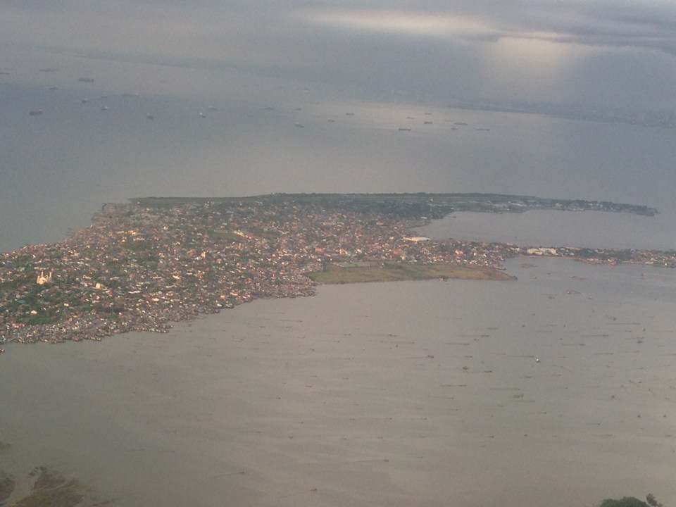 A closer look shows the strip of land that’s pretty much just the runway and a few buildings that serve as terminal and offices.
Whether the proposal for a future international airport at Sangley Point takes off (pun intended) or it is decided that Clark will be the main gateway for what has become a Greater Capital Region (Mega Manila) remains to be seen. There is actually a couple of other proposals put forward before including a site in Bulacan (north of Metro Manila) and at Laguna de Bay (south of Metro Manila). These proposals have basically faded in discussions and only Clark and Sangley Point remain in active consideration. Clark is already there and has a master plan with 3 runways and a huge passenger terminal while Sangley is still basically a concept for the transformation of a small air base and with lots of uncertainties/risks involved especially in implementation. Perhaps what will be for Clark’s advantage and the tipping point is the Bases Conversion and Development Authority’s (BCDA) proposal for a Clark Green City located nearby. The success of this new city is seen partly to be anchored on Clark becoming the main gateway and in tandem with NAIA. In my opinion, this can and would work (and would likely be more cost effective) if the government commits itself to Clark and the required infrastructure to support the airport. This can also help decongesting Metro Manila with a major development in Clark Green City, which is already in the works in as far as BCDA is concerned. As for Sangley, perhaps the question is not whether we can do another Haneda but if we can do it right and within a reasonable time frame given the complexity of the task at hand.
–
Inappropriate designs for pedestrian overpasses
There was a photo that circulated in social media the last two weeks showing electric and telephone cables coming out of the stairs of a steel pedestrian overpass. It was obvious that the people responsible for both the overpass (MMDA) and the cables (power and phone utilities) did not coordinate their work and so people had to risk electrocution to be able to cross the street at what is assumed to be a busy intersection. Such is an example of unsuitable designs and bad implementation of infrastructure projects; in this case, that of a pedestrian facility. There are many other examples of these flawed execution of projects including electric posts in the middle of lanes after road widening projects, short span pedestrian overpasses that are not utilised by people (preferring to cross at ground level) because the road was narrow in the first place. Many are a waste of resources considering they may not have been required in the first place if careful assessment were made about the situation.
The pedestrian overpass under construction at the Masinag junction (photo below) is a good example of what looks like flawed design. The elevated walkway is narrow and is located right at the corners of the intersection. The width is important here because there are many people usually crossing at Masinag and the overpass can become congested for users. The stairs have not yet been constructed but if past designs of overpasses like this is to be considered, the stairs will likely be steep and therefore difficult to use for senior citizens, PWDs and children. Note, too, in the photo that the bridge already obscures part of the traffic signals previously installed at the intersection. This means the lights would have to be reinstalled or transferred so motorists can clearly see the signals.
 Pedestrian overpass under construction at the Masinag junction in Antipolo City
My friends at the DOTC tell me that it is only a matter of time before the Line 2 Extension project is bidded out an construction finally goes underway. Depending on the the final design of the line and end station, there might be a need to revisit the pedestrian overpasses along Marcos Highway. Hopefully, they don’t become like the overpasses along EDSA that had to be raised more due to the elevation of the Line 3 facilities including the catenary for the trains. I’m sure there is a suitable design for pedestrian facilities for crossing the wide Marcos Highway. It only requires careful thinking and creative minds to come together to come up with the appropriate facilities.
–
Compromising on the common station(s) for the Metro Manila rail lines
It seems that the issue regarding the common station for Line 1, Line 3 and the future Line 7 in the North EDSA area has not yet been resolved. The interested private sector parties, Ayala and SM, will not back down on their arguments support each’s proposal for the common station to be located at either of the giant malls that each corporation owns. Ayala’s claim is that the contract for the Line Extension to Cavite stipulates that the common station with Line 3 should be at Trinoma. Meanwhile, SM is claiming the validity of an agreement it made with DOTC on a grand central station to be located across their SM City North EDSA mall. The last one is consistent with an even earlier agreement with the proponents of the future Line 7 for an end station in front of SM.
A compromise solution to the impasse should be in the works and is the responsibility of the DOTC. What if instead of one common station, two stations are made into common ones? There will be no grand central station in the sense that all three lines will terminate as presented in SM’s version nor will there be a common station for Lines 1 and 3 at Trinoma that incorporates a very long walkway to a Line 7 station near Mindanao Avenue. Instead there can be two common stations – one at SM North for Line 1 and Line 7, and another at Trinoma for Line 1 and Line 3. Line 1 will still terminate at Trinoma but can have another stop at SM North where there can be a smooth transfer between Line 1 and Line 7, which terminates at this station. Perhaps there should still be a walkway connecting the two common stations in the interest of pedestrians although seamless fare collection systems and platform design can easily allow Line 7 or Line 3 passengers to ride Line 1 trains between stations to transfer to Line 3 or Line 7.
The common station or stations (depending on what will finally come out of this) should be designed thinking of the best interests of the public who will be using the transit systems and stations. Lost in the discussions are the plight of commuters. Parties claim that their designs are in the best interest of commuters (actually SM has the better set-up of all three lines terminating at one central station) and yet the bottomline for their arguments are very much revenue oriented – not for the transit lines but for their own commercial developments. Its basically one mall vs. another, leaving out the public as incidentals in the discussions. This is why government must intervene and this is where DOTC should show it has a spine after all and is promoting the public good and not favoring one private company over another. And so we’ll wait and see what will eventually come out of this although a lot of people continue to suffer with their inefficient commutes and are definitely becoming more impatient about mass transit systems that should have been constructed a long time ago.
–
