
Home » Land use (Page 4)
Category Archives: Land use
On transport equity
To start the year 2022, I’m sharing another article by Todd Litman. I thought this was a timely one as this is basically about transport equity and the results despite competent planners and perhaps good intentions.
Litman, T. (December 21, 2022) “Good Planners: Bad Outcomes. How Structural Biases Can Lead to Unfair and Inefficient Results,” Planetizen, https://www.planetizen.com/blogs/115621-good-planners-bad-outcomes-how-structural-biases-can-lead-unfair-and-inefficient?utm_source=newswire&utm_medium=email&utm_campaign=news-12232021&mc_cid=35d4ce69aa&mc_eid=9ccfe464b1 [Last accessed: 12/27/2021]
There should be similar studies for the Philippine case. We need to understand and correct bad practices including those related to an over-reliance to what is referred to as “old school” practices (i.e., “nakasanayan na”, “ginagawa na noon pa”, and so on), which is what young engineers and planners are taught by the “old boys” in certain agencies as an initiation of sorts if not part of their ‘continuous orientation’ at these offices.
–
Cities and Automobile Dependence: What Have We Learned?
We end the year with an article from Todd Litman via Planetizen. The topic is something that we really need to ponder on as we or if we are to move towards more sustainable transportation for our cities and municipalities. The experiences during this Covid-19 pandemic should have provided us glimpses of how it could be if we put active and public transport above automobile dependence or car-centricity.
Source: Cities and Automobile Dependence: What Have We Learned?
The main article may be found here (in proper citation for academic/researchers reading this):
–
On parking minimums again
A recent development on parking minimums is about Toronto removing these for new residential developments:
Davis, E.N. (December 16, 2021) “Toronto Removes Parking Minimums for New Residential Developments,” Storeys, https://storeys.com/toronto-removes-parking-minimums-residential-developments/ [Last accessed: 12/23/2021]
Indeed, the building code and local government provisions for minimum numbers of parking spaces for various buildings translate into more expensive units for prospective residents or lessees. Perhaps someone should be collecting and analyzing the data on buildings such as high-rise residential and commercial developments? This is to have the numbers for an objective and factual discussion about parking minimums for these types of development. Here is an excerpt from the National Building Code showing examples of minimum parking requirements for residential buildings:
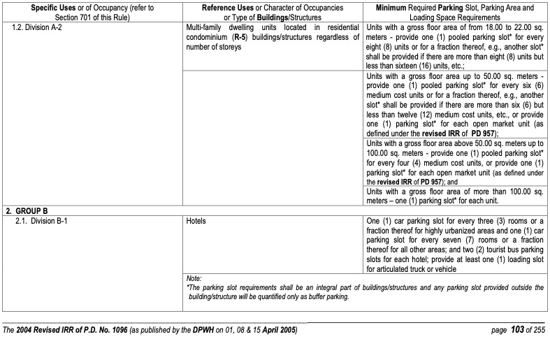
How many parking spaces are actually bought or leased/rented among the hundreds usually provided in buildings, to comply with building code and local government requirements? What is the ratio of parking slots per unit? Where are the trip-ends for these developments (especially for residential buildings)? The answers to these questions may help us understand the situation and formulate revisions to building code as well as local government requirements for the minimum number of parking spaces.
–
On housing and urban planning
I’m sharing this article on housing in Montreal. The relevance is basically related to urban planning and its implications to transportation.
Polese, M. (Winter 2020) “How One City Makes Housing Affordable: The Montreal Example,” City Journal, https://www.city-journal.org/montreal-affordable-housing#.YbQ7E3HXwwU.facebook [Last accessed: 12/18/2021]
I’ve shared and posted a few articles on housing before. These include my own opinions about housing and its close links to transportation. Having lived in Japan and Singapore, I I saw first hand how concepts like transit oriented development (TOD) and socialized housing were implemented. I think there’s a lot we can learn but haven’t so far from these examples that will also address problems associated with sprawl including the lagging development of transportation systems to cover the increasing demand.
–
On housing and transportation
I’ve written about how we should not be trying to isolate transportation as if it is singly at fault for the transport and traffic mess many of us are in at present. There are many factors affecting travel behavior including mode choice. Travel distances, travel times and mode choices are not a consequence of transportation system (including infrastructure) alone. Land development and pricing especially those pertaining to housing are critical in how people decide where to live. These are intertwined with transportation and can be quite complex without the proper data or information to help us understand the relationship. That understanding, we are to assume, should lead us to the formulation of policies intended to correct unwanted trends and perhaps encourage more compact developments that are closer to desirable concepts such as the 15-minute city.
Here is an interesting article to enrich the discussion on this topic:
Dion, R. (October 28, 2021) “Coupling Housing and Mobility: A Radical Rethink for Freeways,” Planetizen.com, https://www.planetizen.com/features/115126-coupling-housing-and-mobility-radical-rethink-freeways?utm_source=newswire&utm_medium=email&utm_campaign=news-11012021&mc_cid=85ec2b565f&mc_eid=9ccfe464b1%5BLast accessed: 11/3/2021]
The first thing that came to my mind are residents of northern and southern Metro Manila and the surrounding provinces. Many chose to buy houses there and beyond (i.e., Bulacan, Laguna and Cavite) and yet work or study in Metro Manila CBDs like Makati, Ortigas and BGC. And they do use the tollways (e.g., NLEX, SLEX, CaviTEX, Skyway) to get to their workplaces and schools.
This is also a relevant and timely topic in the Philippines as many cities are already headed for sprawls that will inevitably put more pressure on transportation infrastructure development that usually leans towards car-oriented projects (e.g., road widening, new roads, flyovers, etc.) rather than people-oriented ones (e.g., modern public transportation systems, bikeways, pedestrian infrastructure). Note that only Tokyo has developed an extensive enough railway system to cover the sprawl that is the Tokyo Metropolitan Area, which if interpreted loosely also includes Yokohama, Kawasaki and Chiba in the sprawl. No, we cannot build as fast to have as dense a railway network as Tokyo’s or other cities with similar rail systems. And so we have to figure out another way to address this problem.
–
Parking: minimum or maximum
The National Building Code (NBC) of the Philippines stipulates the minimum number of parking spaces or slots per type of establishment and intensity of development (i.e., according to area or other parameters). These established provisions are generally called parking minimums. The NBC’s provisions are already archaic by current standards and need to be revised but not in the way it was apparently developed. The NBC needs supporting evidence from studies (are there any dependable ones around?) on parking requirements including those for bicycles and motorcycles. These should clearly not include or impede the requirements of pedestrians. And local government units must be required to enforce these NBC provisions.
Here is an article that discusses the proposal for new limits on parking, particularly in large developments in Boston, Ma. in the US:
The article points to this one:
City of Boston (September 20, 2021) Maximum Parking Ratios, https://www.boston.gov/departments/transportation/maximum-parking-ratios [Last accessed: 10/19/2021]
I must admit that I still have to do a lot of reading on this. There are some who are calling for the abolition of parking minimums but you just can’t do this so abruptly without understanding the context and current set-up. We are not Boston or San Francisco or Hong Kong or Singapore in terms of the transport infrastructure and services and the progressiveness of policies including those governing or covering housing and other factors that come into play with transportation. Sprawl and the resulting pressures (requirements for efficient travel) on the transportation system is not transport’s fault or responsibility alone like what some articles or infographics make it appear to be. It is very much about land use and land development, and the policies and the political economy behind these developments.
–
On defining the 15-minute city
I have shared articles and briefly written about the concept of the 15-minute city on this blog. Here is another discussing how a 15-minute city is defined:
(February 8, 2021) “Defining the 15-minute city,” Public Square, https://www.cnu.org/publicsquare/2021/02/08/defining-15-minute-city [Last accessed: 8/10/2021]
Here is an image from the article:
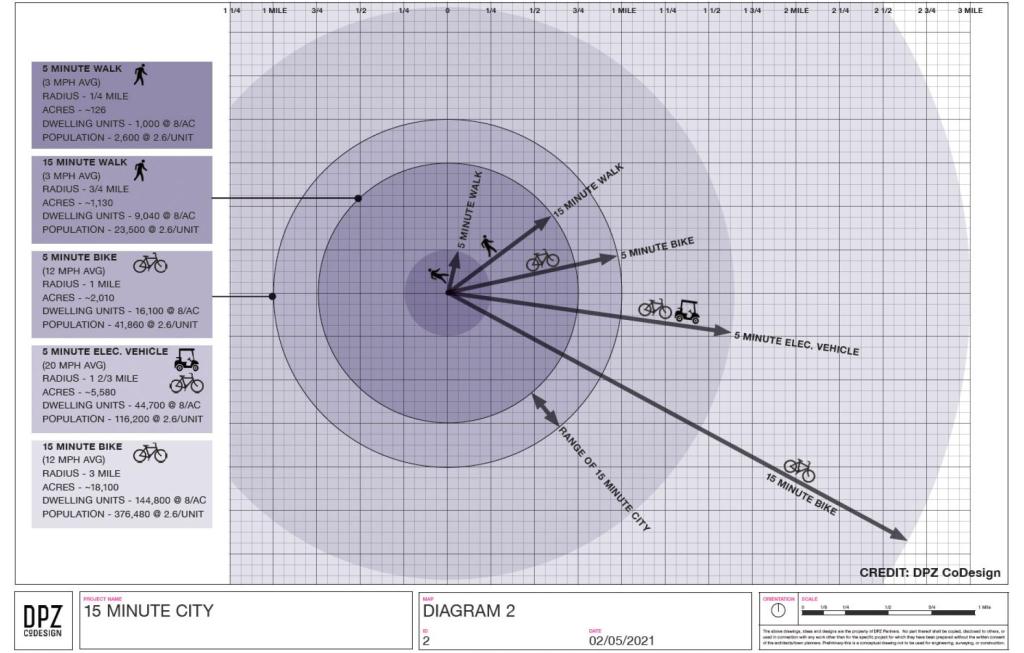
Again, it is important to contextualize these concepts. I share these as references and topics for discussion. Of course, I have my own opinions about this and I have written about those in previous posts. I guess in the Philippine context, we can include the pedicab or non-motorized three-wheelers in the discussion. These are also very popular modes in many cities and municipalities despite their being also prohibited along national roads like their motorized counterparts. It would be nice to have more visuals in the form of maps that show travel times for essential destinations or places like hospitals, markets, grocery stores, workplaces and, of course, homes. I assume there is at least someone, somewhere who perhaps have made multi-layer maps of this sort and attempted to related them along the lines of this concept of a 15-minute city (or perhaps the even older “compact cities”).
–
Are roads really designed just for cars?
The answer is no. Roads were and are built as basic infrastructure for transport no matter what the mode. However, the standards for dimensions (i.e., number of lanes, widths, etc.) are based on the motor vehicle capacity, and structural standards (i.e., thickness, strength, reinforcement, etc.) are based on the weights they are supposed to carry over their economic lives. The pavement load as it is referred to is usually based on the cumulative heavy vehicle traffic converted in terms of the equivalent standard or single axles or ESA. An ESA is 18,000 pounds or 18 kips in the English system of measurements or 8.2 metric tons in the Metric system.
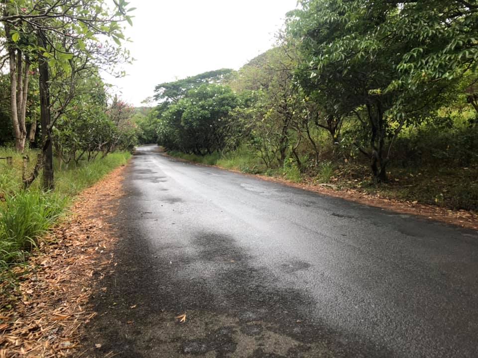 A typical local road – is it really just for cars or is it also for walking and cycling? Or perhaps animal drawn transport?
A colleague says many of the posts in social media pitting bicycles with cars are already quite OA (overacting). I tend to agree as I read how people generalize roads being car-centric. Roads have been built basically to serve a avenues for transportation. They were improved over time in order to have more efficient ways to travel by land. It didn’t hurt that vehicle technology also developed over time and bicycles somehow became less popular than the cars and motorcycles. The motorcycle itself evolved from bicycles so in a way, it is the evolved and mechanized form of the two-wheeler.
In a perfect world, people would be sharing the road space and it would be equitable among different users. In a perfect world perhaps, it won’t be car-centric as there would probably be better public transport options and transit will be efficient, reliable, comfortable and convenient to use.
The reality, however, is that we do not live in a perfect world and transformations like the ones being pitched on social media are nice but are also not as inclusive and equitable as their advocates claim them to be. I’ve always said and written that you cannot simply change transportation without also implementing changes in land use and housing in particular.
Why do we need wide roads connecting suburbs and urban areas? Why is there sprawl? Why do people live in the periphery of CBDs or the metropolis? It is not just about transport though it seems easier to focus on this. Even transportation in Japan, with Metropolitan Tokyo and its equivalent of NCR plus as a subject, needs to be properly contextualized for land use and transport interaction and development. It seems that even with a comprehensive and efficient railway network, there are still shortcomings here and there. We don’t have such a railway network (yet) so we need to find ways for easing the currently long and painful commutes many people experience on a daily basis. That means continued dependence on road-based transport and trying to implement programs and schemes to improve operations.
–
On predicting how new developments will affect pedestrians
I’ve been involved in a number of traffic or transport impact assessment (TIA) projects in the past. In these assessments, not much is usually written about the impacts to pedestrians though we make sure that there is a section discussing their needs (e.g., sidewalks, crossings, footbridges). Unfortunately, even with specific recommendations, there is no assurance that the proponent will revise their designs. The typical TIA in the Philippines is undertaken after there have been architectural plans already prepared if not completed. By completed here, I mean they are practically final from the perspective of the client or proponent. The exception it seems is a big mall chain that seems to constantly revise their plans and for which our recommendations are almost always considered and incorporated in design.
I am sharing this recent article on the development of a new traffic model to predict the impacts of new developments on walkers.
Wilson, K. (April 26, 2021) “New Traffic Model Predicts How New Developments Will Affect Walkers,” StreetsBlog USA, https://usa.streetsblog.org/2021/04/26/new-traffic-model-predicts-how-changes-affect-walkers/ [Last accessed: 5/12/2021]
From the perspective of doing TIAs, I think that there should be a conscious effort of including the needs of pedestrians (walkers) and cyclists in impact assessments. Too often, (and I too am guilty here), there is but a minor mention of their needs and recommendations can be disregarded by both proponents (e.g., little or no change in designs to accommodate pedestrian requirements) and the local government (i.e., no push to make sure pedestrian needs are addressed).
On the tech side, there is a local development that can be used for counting pedestrians and cyclists. The TITAN project funded by the DOST-PCIEERD developed a tool that can count pedestrians and cyclists in aid of studies involving them. Such tools can be useful for data collection regardless of whether there is a new project or a TIA being undertaken.
–
On building the ideal city from a transportation perspective
There’s a not so old article that popped in my timeline of articles I’ve read the past years. I thought I would make a quick share of it here. It is a good read and something that will never be irrelevant for as long as we have not redeveloped our cities and municipalities for transport equity and sustainability. Here’s a takeaway from the article:
“The ideal city is a place where lots of different kinds of people with lots of different amounts of money can live and work. It has to be easy to get around without a car, even for people whose bodies can’t ride bikes or hop over potholes, and for people who have kids to drop off on the way to work and groceries to buy on the way home, and maybe flowers to buy next door to the dry cleaner’s. These are places where people want to live, because it’s nice there. The fact that those places also adapt to and mitigate climate change instead of causing it is a bonus.”
Here’s the article from last year:
Rogers, A. (April 1, 2020) “Build Cities for Bikes, Buses, and Feet—Not Cars,” Wired, https://www.wired.com/story/cities-without-cars-san-francisco-jeff-tumlin/?bxid=5bd6761b3f92a41245dde413&cndid=37243643&esrc=AUTO_OTHER&source=EDT_WIR_NEWSLETTER_0_ENGAGEMENT_ZZ&utm_brand=wired&utm_campaign=aud-dev&utm_mailing=WIR_Classics_042921&utm_medium=email&utm_source=nl&utm_term=WIR_Daily_TopClickers [Last accessed: 4/30/2021]
–
