
Home » Mode Share (Page 22)
Category Archives: Mode Share
Transport and traffic purgatory, paradise and inferno
A lot of people have been referring to the traffic congestion and other derivative issues that will be the result of the construction of several transport projects around Metro Manila as “traffic armageddon.” Some friend have appropriately (I think) referred to it more as “car-mageddon.” This seems to be the case since it is perceived to have the most impact on car users than public transport users, cyclists or pedestrians. This is far from the truth as there are more people taking public transport, cycling or walking than those driving their own cars. In fact, estimates for Metro Manila indicate that 70-80% of travelers take public transport while 20-30% take private vehicles. These mode splits do not include bicycles or walking, which obviously will further decrease private car shares.
I would rather refer to this period of construction as a sort of “purgatory” though it has nothing to do with the cleansing that’s associated with it. There is still the suffering involved while improvements are being implemented. But, most importantly, there is hope at the end of this process. This “hope” is not necessarily the “light at the end of a dark tunnel” kind of thing as surely population and the number of vehicles will surely increase over time even as the transport projects are being implemented. By the time these are completed, there are sure to be more people, more vehicles, as well as more of other developments that will put our transport system to a stress test. We can only hope that the designs of these infrastructure we are building now are based on honest to goodness trip or traffic forecasts. Otherwise, we’ll end up with congested or saturated systems by the time they start operating.
Unfortunately, most projects mentioned and those we know have the green light and would likely be proceeding with construction in the near future are basically road projects. It’s ironic considering that what Metro Manila urgently, and maybe desperately, needs now are public transport systems including the much delayed MRT 7, LRT 2 Extension and LRT 1 Extension. The proposals for Bus Rapid Transit (BRT) seem to be in a limbo, too, despite extensive studies and surveys to support BRT along corridors such as Ortigas Avenue and Circumferential Road 5. These are blamed on institutional and legal impediments including allegations of shortcomings among officials of agencies responsible for these infrastructure.
I am aware of an initiative led by an environmental lawyer seeking to effect the redistribution of road space in favor of public transport users, cyclists and pedestrians. I think such actions are useful from the perspective of getting the attention necessary to push government and private sector players to have a sense of urgency not just in words but also in actions in as far as transport infrastructure programs and projects are concerned. We are already lagging behind our ASEAN neighbors with regards to infrastructure and at this pace, it is likely that less developed countries like Cambodia and Myanmar might just overtake us in the foreseeable future. From another perspective, it is hard to push for sharing the road when people really don’t have better options for commuting. Walking and cycling are not for everyone and many people have turned to the motorcycle to solve their transport woes. In the latter case, motorcycles are perceived as a vehicle that’s fuel efficient and allows the users to zip through congested streets often at high risks of being involved in a crash or spill.
We can only achieve “paradise” in our highly urbanized cities if we build these mass transit systems along with the pedestrian and cycling facilities that will complement each other. Those for whom car travel is a necessity would also benefit from reduced road congestion so it will eventually (hopefully) play out well for most people. Meanwhile, we would have to endure transport and traffic hell (some more and longer than others) as the government and private sector embark on this round of infrastructure projects implementation. It helps to look back at our experiences with the last major batch of projects in the latter part of the 1990’s when the number coding scheme was first implemented. At the time, it was implemented as a temporary measure to alleviate congestion while projects where being implemented. What was a temporary measure is now still being implemented along with a truck ban that has also been evolving the past years with the latest being the one implemented by the City of Manila starting last February 24. Will these vehicle restraint schemes be modified to cope with the traffic congestion expected from projects like the Skyway connector? Will these be relaxed or removed after all these projects have been completed? Your guess is as good as mine.
–
From FX to UV Express – a story of evolution
For those not familiar with its evolution, the UV Express has an interesting history. It started as a contracted taxi service utilizing the new Asian Utility Vehicle (AUV) model released by Toyota that they called the FX (The same model is known as the Kijang in Indonesia.). I can say that I witnessed the birth of FX services in the 1990s when taxis were approached by commuters having common destinations. I was among those who were desperate enough to get home and tired of getting into those long lines of people waiting for jeepneys in Cubao. The lines were not all that bad though as it used to be worse when people had to box out one another to board a jeepney as they arrived near Ali Mall.
Taxis had the advantage of not having fixed routes so they could bypass congested road sections. They could take alternate routes that despite covering longer distances, incurred shorter travel times. Passengers negotiated with the drivers for a common destination and a fare that’s typically higher than what would be charged if the meter was used. I remember that there were times when passengers (like me) negotiated with the driver with the dare to run the meter just to prove that he’d be better off with the money we would be paying rather than wait for regular fares. Of course, this practice of negotiating was illegal as taxis in Metro Manila were metered. But passengers were quick to help out the cabbie in case he gets caught, with everyone claiming that he or she knew the others and that they were traveling as a group. One use of a running meter was that they were a group paying regular fare.
Taxi operators and drivers quickly caught on to the idea and many eventually became enterprising. These were mostly FX drivers who could carry 5 to 7 passengers depending on the seat configuration for the vehicles. Toyota took full advantage of government incentives for AUVs by introducing what was claimed to be 10 seater vehicles, maximizing space at the middle and rear to seat a total of 8 people in addition to 2 in the front. This also translated into a maximization of revenue per load of 10 people and soon, “standard” fares were being established for certain routes like Cubao-Cainta Junction, which I remember cost 20PhP per person regardless of whether you were alighting before Cainta Junction. Eventually, issues were raised regarding their operations as contracted vehicles as they were still classified as metered taxis and should have not refused single or few passengers. There were also issues regarding their competing directly with jeepneys as some FX plied routes similar to jeepneys especially when traffic was more manageable. Eventually, the DOTC and the LTFRB moved to regulate this emergent transport service and formalized (fixed) routes and franchises rather than retain their flexibilities like taxis. In effect they became express shuttle services and fares and rules were also set accordingly, also to protect the interests of the riding public.
 Toyota Revo AUV UV Express vehicle plying the Pasig-Ayala Center route
It became known as Garage to Terminal (GT) Express during the last administration. There was a joke then that the term used was according to the nickname of the then Chairman of the LTFRB. It’s name again was changed into Utility Vehicle (UV) Express after the change in administration.
 Nissan Urvan van UV Express at the Puregold at the NLEX Valenzuela Exit
UV Express now proliferate around Mega Manila and come in different vehicle types and sizes. Most are AUV’s like the Toyota Revo, Isuzu Crosswind or Mitsubishi Adventure. There are also vans like the Toyota Hi-Ace and Nissan Urvan. But there are also custom made vehicles like those utilizing the Mitsubishi L300 prime mover and fitted with a cab that seats 14 to 16 passengers. The latter types have capacities similar to jeepneys and airconditioning is somewhat weaker compared to the legit AUVs and vans. I think the UV Express vehicles are here to stay and they do serve a certain segment of commuters. However, while I also think their numbers are excessive (and government through the LTFRB needs to address this) there is really not much to argue about if more efficient and higher capacity and good quality transit systems cannot be realized in our cities. People deserve options for commuting and for those taking public transport, these UV Express services provide good quality transport that they are willing to pay for. Many of these services might just meet a natural death or decline once a better transport system is in place along main corridors but that seems a long way off from now given continued failures in mass transit project implementation.
–
More pedestrian facilities please!
I took a couple of photos one late afternoon on a weekday on my way home. I wanted to have a picture of typical jeepney overloading during the afternoon peak. Typically, jeepneys would allow “sabit” or passengers hanging from behind the jeepney. This practice is actually prohibited and carries a fine if jeepney drivers are apprehended. And that is usually a big “if” considering enforcers turn a blind eye to the practice especially during peak periods when it is difficult to get a ride.
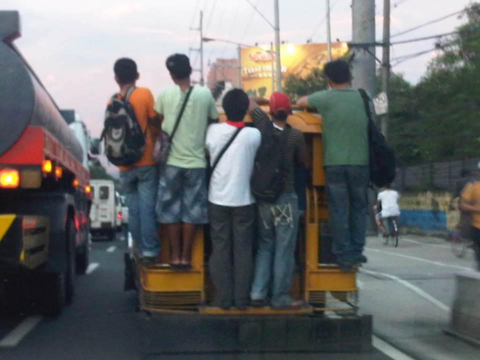 Jeepney full of sabit or hangers-on in heavy traffic along the eastbound side of a major highway
I also happened upon an opportunity to take a photo of the overloaded jeepney together with pedestrians walking along the walkway at the roadside. Though the photo was not so clear, it captured the image I wanted with people opting to walk while others took a risky ride on a jeepney. The cyclists in the photos were just bonuses and added to the visual of alternatives for mobility.
 Pedestrians and a cyclist along the widened walkway/bikeway along Marcos Highway
Walking remains as the mode of transport with the highest share when all modes, motorized or non-motorized, are compared. While there is a strong clamor from cyclists for bikeways and for cycling to be taken up by more people as an option for commuting, the reality is that cycling is not really for everyone. It is a viable and healthy mode but should also fit in a hierarchy of modes. Most people walk and walking should be encouraged over distances where it is most suitable. Facilities for walking need to be provided and properly designed so that people can walk safely and most efficiently like the example in the following photo taken during another weekday late afternoon.
 People walking along Marcos Highway
Local governments help promote walking by making sure sidewalks are provided and clear of obstructions. Perhaps walkability can be used as an indicator or parameter for a city to be qualified as livable and true to the advocacy of sustainable transport. Walking should be encouraged to promote healthy living as it incorporates exercise in our daily routines. More people walking should also increase awareness for the advocacy for clean air and help initiatives to improve air quality, particularly efforts to reduce harmful emissions by motorized vehicles. Thus, it is not difficult to understand how investing in pedestrian facilities and promoting walking is not a smart move and a beneficial one for any politician’s constituency.
–
Rationalizing public transport in the Philippines
I got a copy of the recent study “Development of a Mega Manila Public Transportation Planning Support System” conducted by UP Diliman’s National Center for Transportation Studies (NCTS) for the Department of Transportation and Communications (DOTC). The main outcome of the study was a planning support system that includes an updated database of bus, jeepney and UV Express routes for Metro Manila and its surrounding areas (collectively called Mega Manila), and a calibrated travel demand model for the region that is supposed to be used by the DOTC and the LTFRB in transport planning including the rationalization of public transport in the region. Among the notable recommendations for addressing public transport issues is the following on the classification of routes according to passenger demand, which I quote from the study:
“…routes and modes may be classified and prioritized as follows:
- Routes with Very High Passenger Demand [>160,000 passengers per day] – shall be served by high capacity modes such as rail-based transit or Bus Rapid Transit(BRT) with passing lanes.
- Routes with High Passenger Demand [100,000 to 160,000 passengers per day] – shall be served by high capacity vehicles such as Bus Rapid Transit System (BRT) without passing lanes;
- Routes with Medium Passenger Demand [10,000 to 100,000 passengers per day] – shall be served by PUVs with 60 or less passengers/seats but not less than 22 passengers (excluding driver) such as buses, CLRVs with more than 22 passengers/seats (including driver), or with 90 passengers/seats in the case of double decker or articulated buses;
- Routes with Low Passenger Demand [not exceeding 10,000 passengers per day] – shall be served by PUVs with less than 22 passengers/seats (including driver) such as jeepneys and other paratransit modes.
Under this principle, high capacity modes would have priority in terms of CPC allocation and transit right of way in a particular route over lower capacity modes with the exception of taxis. The latter, after all, operate as private cars rather than PUVs with fixed routes.
Applications to operate bus and/or minibus service in jeepney routes can be considered, but not the other way around. Similarly, bus service applications can be considered in minibus routes but not otherwise.
Based on the analysis of routes, the establishment of public transportation routes and the corresponding modes of services may be based on the following criteria:
• Passenger demand patterns and characteristics
• Road network configuration
• Corresponding road functions (road hierarchy)
• Traffic capacities and
• Reasonable profits for operation of at most 13% ROI.”
[Source: DOTC (2012) Development of a Mega Manila Public Transportation Planning Support System, Final Report.]
An interesting figure in the report is an illustration of how services can be simplified using buses and rail transport as an example. The following figure shows two maps: one showing the plotted EDSA bus routes (left) and another showing a more consolidated (and rational) route network for buses complementing existing and proposed rail mass transit systems.
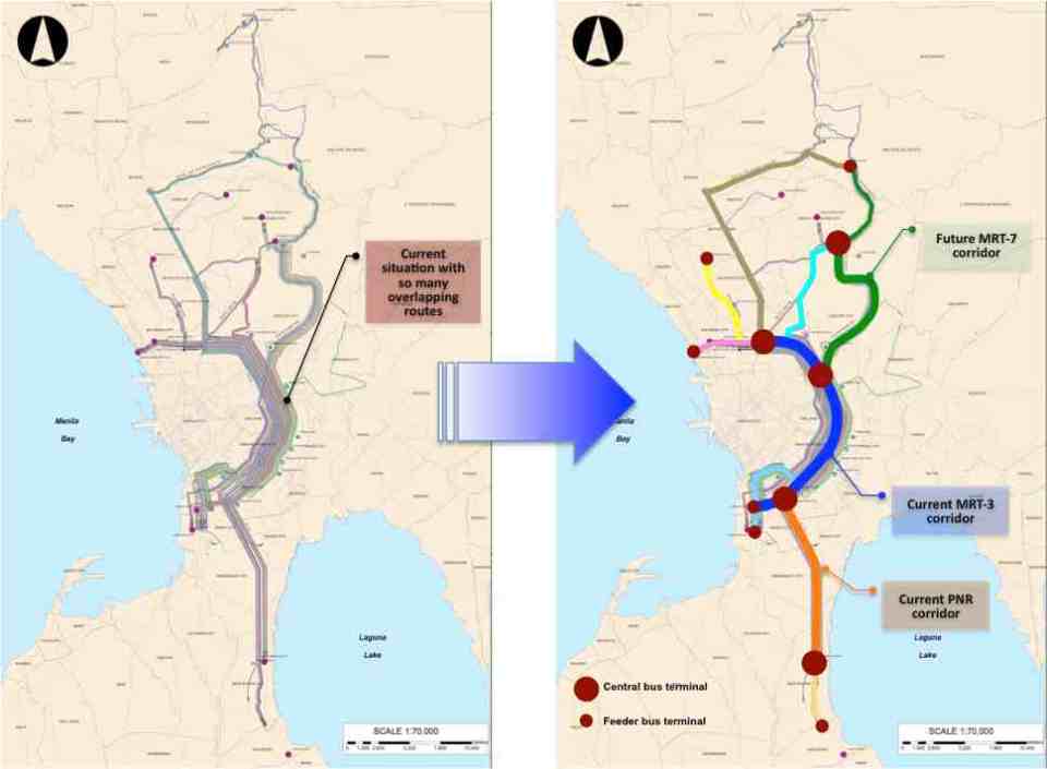 Simplifying bus transport services (source: DOTC, 2012)
What are not included in the figure above are the prospects for Bus Rapid Transit (BRT) systems for Metro Manila. Since the Final Report was submitted in mid 2012, there have been many discussions for BRT in the metropolis and current efforts are now focused on the assessment of a BRT line along Ortigas Avenue. The World Bank is supporting the evaluation of a route between Tikling Junction near the boundary of Antipolo and Taytay (Rizal Province) and Aurora Boulevard. There are also informal talks of a BRT line along Commonwealth Avenue but that would have implications on the proposed MRT-7 along the same corridor. Nevertheless, such mass transit systems have long been required for Metro Manila and their construction have been overdue. A more efficient public transport system will definitely have tremendous impacts on how we commute between our homes, workplaces, schools and other destinations. Long distances can easily be addressed by better transport options and could actually help solve issues pertaining to informal settlements, relocations and housing. That topic, of course, deserves an article devoted to this relationship between transport and housing. Abangan!
–
Transport gaps
I first learned about the concept back in the 1990’s when I was a graduate student at UP majoring in transportation engineering. The concept on transport gaps was first mentioned in a lecture by a visiting Japanese professor as he was discussing about transport modes, particularly on which was suitable or preferable over certain travel distances and which could carry more passengers. Another time later and while in Japan, I heard about the concept during a presentation of a friend of his technical paper on public transport.
The figure below is one of many possible illustrations of the concept of transport gaps. In the figure, a distinction is made for mass transport and individual transport. As the original figure is likely taken from a textbook or a paper (probably from Japan), shown with a white background are the more conventional modes of transport including subways, urban and suburban railways, walking and a mention of the shinkansen (more popularly known as the bullet train). With a gray background in the original figure is a category on new urban transit systems that include monorails, AGTs and LRTs. If we attempt to qualify local transport modes such as jeepneys, UV Express, tricycles and pedicabs into the graph, the outcome can be like what is illustrated with different color backgrounds in the figure below.

The concept of transport gaps allow us to visualize which modes are suitable for certain conditions where other established modes of transport may not be available or viable. In the original figure, the gap in Japan is filled by new urban transit systems. In our case, gaps are filled by so-called indigenous transport modes such as jeepneys, multicabs, tricycles, pedicabs and even habal-habal (motorcycle taxis).
There are gaps in the Philippine case probably and partly because of the slow development of public transport systems such as the mass transport modes shown in the preceding figure. There was a significant gap right after World War 2 when the tranvia and other railways were destroyed during the war. That gap was filled by the jeepney. There was also a gap in the early 1990’s that was eventually filled by FX taxis. Such gaps can obviously be filled by more efficient modes of transport but intervention by regulating agencies would be required and rationalizing transport services can only be addressed with the provision of mass transport options complemented by facilities for walking and cycling that will complement these modes.
–
But seriously…recognizing walking as a mode of transport
There is a general observation that urban planning in the Philippines, including planning and design for transport, revolves around motor vehicles. In fact, much of what we think are sound policies and guidelines, even rules of thumb, are car-oriented rather than people-oriented. Our love for the car is often traced to our being a colony of the United States and our orientation to cars have been reinforced over the years by policies, plans and projects that seem to be biased for car users while detrimental to commuters in general. In fact, we have been used to having roads built and widened that these types of projects seem automatic, no brainer solutions to the traffic problems we encounter everyday. Not that this is a bad thing, considering that we do have many missing links to complete and infrastructure to build where they are needed. Yet, for many of our highly urbanized cities, public transport infrastructure has been too slow to address the demand for movement.
Metro Manila is already choking in as far as traffic is concerned and our proposed solutions still are road widening and the call for elevated expressways. Meanwhile, we have poor road public transport services and a limited rail or mass transit network. It seems that most of the plans for trains and BRTs have never left the proverbial pipeline and as such, we continue to languish in I would like to think that a lot of people would want to take public transport if only the quality of service is similar to systems in Singapore, Hongkong, Kuala Lumpur or even Bangkok or Jakarta. We have to deliver on this end, which will also see our streets begin to become decongested as vehicles will naturally decrease with people choosing PT over their cars, especially in this period of increasing fuel prices.
Of course, these public transport infrastructure carry hefty price tags. And so to complete the picture and solve the puzzle of transport in cities like Metro Manila, Cebu and Davao, we would need to address what is perhaps the most basic for of transport that is often forgotten when talks center on highways and mass transit – walking. It is a fact that walking is the mode with the highest share for transport; dwarfing all other modes since we all walk at some point of our trips (e.g., Car users still have to walk to and from the parking spaces.) Unfortunately, we seem to have become lazy, preferring to ride than to walk and making so many excuses even when the facilities for walking are already provided and conditions favor walking over motorized transport. Of course, the main challenges for ensuring the safety and comfort of those who choose to walk remain and investments are required for more infrastructure to encourage walking. There are good practice examples like the walkways connecting buildings at the Makati CDB and the sidewalks of Quezon City. These are, however, more the exception than the rule and so there is still a need to actually “formalize” walking as a mode of transport and one that could probably save us a lot of fuel, reduce emissions and, most importantly, improve our health and well-being.
Following are excellent articles for reading, and for consideration when we re-think what we are doing to improve transport and mobility in our cities. A re-orientation is in order for us to address
(Note: the sources and links to the online articles are shown below and in the files. These are made downloadable here only to facilitate access to the articles. There is no intent for any copyright infringements.)
Why don’t Americans walk more? The crisis of pedestrianism:
What scientists know about how pedestrians really behave:
Walking_in_America__What_scientists_know_about_how_pedestrians_really_behave_
How walk score puts a number on walkability:
Walking_in_America__How_Walk_Score_puts_a_number_on_walkability_
With America and the rest of the world taking a second and perhaps critical look into how they are planning their transport systems and focusing on encouraging people to walk, we should perhaps take this as our cue to also re-think how we are planning and designing our systems. We should, and not be too dependent on the recommendations of studies past and present that seemingly try to simplify our plights as something that can be solved by roads and cars alone.
–
Transport mode shares in Metro Manila
Fairly recent surveys (first quarter of 2011) along major corridors in Metro Manila have yielded the following data on transport modes shares in the National Capital Region. Such data, while quite specific for the corridors surveyed, strongly indicate that most people take public transport. As such, it is quite logical that public transport be prioritized and perhaps provided with the road space they require to be more efficient in conveying passengers to their destinations. There are mixed results in terms of which types of vehicles tend to dominate the road and these are noted below. Note that data for rail is not included but should favor public transport as well. Taxis, in this case, are classified among private vehicles. Trucks are not considered here as passenger vehicles though they do carry people.
 Person trip mode shares along Aurora Boulevard eastbound (to Rizal & Marikina) – jeepneys account for 79% of road-based transport while cars carry 10% of person trips. In terms of vehicle share of the road, cars account for about 25% of the road while jeepneys take up about 59% after converting jeepneys into passenger car units using the assumption of 1.7 pcu = 1 jeepney. Such assumption is also used in other estimates.
 Person trip mode shares along Aurora Boulevard westbound (to Cubao/Quezon City) – jeepneys account for 76% of road-based transport while cars carry 14% of person trips. Meanwhile cars occupy 31% of the road while jeepneys use 57%.
Interesting for the above statistics is the fact that these numbers do not reflect the actual share of public transport given that there is a rail transit service along this corridor. LRT Line 2, however, terminates before reaching the Province of Rizal, which necessitates the transfer of passengers from rail to mainly jeepneys towards their final destinations.

Person trip mode shares along Ortigas Avenue eastbound (to Rizal Province) – jeepneys account for 55% , buses 13% and AUVs 12% of road-based transport (total of 80% for PT) while cars carry only 15% of person trips. Cars occupy 37% of the road while jeepneys eat up almost the same at about 37%. AUVs are quite significant along this corridor taking up 12% of the road. Surprisingly, buses only occupy about 5% assuming 2.5 pcu = 1 bus. Perhaps Ortigas can be decongested if public transport services along the corridor are rationalized with many jeepneys retired in favor of the higher capacity buses.

Person trip mode shares along Ortigas Avenue westbound (to Mandaluyong/Manila) – jeepneys account for 55% , buses 20% and AUVs 8% of road-based transport (total of 83% for PT) while cars carry only 13% of person trips. Cars take up 38% of the road, jeepneys also 38%, AUVs 9% and buses only 4.5%.

Person trip mode shares along Commonwealth Avenue northbound (to Novaliches) – jeepneys account for 30% , buses 35% and AUVs 5% of road-based transport (total of 70% for PT) while cars carry 26% of person trips. Cars take up 57% of the road, jeepneys 17%, AUVs 6% and buses about 12%. Meanwhile, motorcycle account for about 8% of road space along Commonwealth NB. Note that Commonwealth is the widest road in the country with sections having up to 10 lanes per direction. The two outermost lanes are typically designated for PUVs while the 4th lane from the roadside is designated as a motorcycle lane.

Person trip mode shares along Commonwealth Avenue southbound (to Elliptical) –
Note that there is a proposed MRT 7 to be constructed along Commonwealth and that system will also favor public transport users. Such a system should be more efficient in carrying passengers along the corridor and should provide an opportunity to rationalize PUJ and PUB numbers along Commonwealth. And such an opportunity should be taken and not passed up if government is really serious in improving transport in Metro Manila.
Person trip mode shares throughout the country will surely have similar numbers if not higher shares for public transport compared to Metro Manila. This more than underlines the impetus for providing safe, efficient public transport services for Filipinos – a commitment that should not only be stated or printed but actively pursued with government in the forefront rather than on the sidelines.
Graphs and other stats mentioned derived from data from surveys for the Mega Manila Public Transport Planning Support System (MMPTPSS), 2011.