
Home » Policy (Page 11)
Category Archives: Policy
Another definition of the 15-minute city
We begin 2023 with an informative article defining the “15-minute city”. This is actually an entry in Planetizen’s Planopedia, which contains definitions of fundamental concepts in urban planning:
Ionescu, D. (December 2022) “What is a 15-minute City?” Planetizen, https://www.planetizen.com/definition/15-minute-city?utm_source=newswire&utm_medium=email&utm_campaign=news-12292022&mc_cid=ee083e2ee7&mc_eid=9ccfe464b1 [Last accessed: 1/1/2023]
I’ve written and shared articles about this concept before. Here are a couple from 2021 where I offered my opinions about the concept as already applied in the Philippines:
https://d0ctrine.com/2021/08/13/on-defining-the-15-minute-city/
https://d0ctrine.com/2021/04/07/didnt-we-already-have-15-minute-cities-and-towns-in-the-philippines/
–
Examples of legislative actions in support of active transport
While the Philippine government and various local government units seem to be reneging on their commitments to support active transport, other countries have been building on their gains during the pandemic. Here are examples of legislations in New York State that will support active transport through funding of complete streets projects and institutional arrangements for representation of transit dependent individual:
The article is about two legislations:
Legislation (S.3897/A.8936-A) Provides Funding for “Complete Streets” Projects Inclusive of a Holistic Approach to Street Design
Legislation (S.3959-B/A.7822-C) Adds Board Seats to NFTA, RGRTA, CDTA, and Central New York Regional Airport Authority Dedicated to a Transit Dependent Individual
We hope to see something like these at least at the local level. Perhaps if LGUs are able to legislate and implement these, there will be more good practice examples that will compel national government to support active transport development. The latter is actually ironic considering that many plans are supposed to spell out the national government’s commitment to active transport. There are still live memorandum orders and department orders supporting and promoting active transport. Are these also being waylaid? That will be tragic for transportation if we didn’t learn or gain anything from the experiences during this pandemic.
–
On the future of bike lanes in Metro Manila and other cities and municipalities in the Philippines
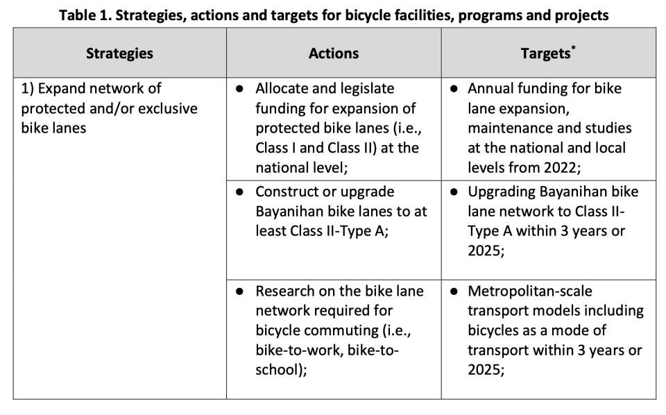
My friends and I were talking about the current buzz about the bike lanes including statements made by certain personalities (influencers, advocates, government officials, etc.) about biking and bike lanes. There were many recent pronouncements of motorcycles being allowed to use bike lanes or the outright removal of bike lanes. We all agreed this was backward and the way forward is to build on the current network and facilities. What we have in our cities and municipalities are not perfect and far from ideal but they are a start and perhaps the foundation for a bikeway network that can eventually make a dent on the car-centric transportation we have.
I share below the strategies, actions and targets for bicycle facilities, programs and projects from the Network Planning for the Establishment of Bike Lanes in Metro Manila, Metro Cebu and Metro Davao that was completed middle of 2022. The project is DOTr’s with support from the UNDP. The table is from the Final Report of the project.


A Happy Christmas to all!
–
Shared article: Active and Micro Mobility Modes Can Provide Cost-Effective Emission Reductions–If We Let Them
I’m sharing this article on active and micro mobility modes from Todd Litman, published in Planetizen.com:
Source: Active and Micro Mobility Modes Can Provide Cost-Effective Emission Reductions–If We Let Them
From the article:
“Common Active Transportation Leverage Effects:
–Shorter trips. Shorter active trips often substitutes for longer motorized trips, such as when people choose a local store rather than driving to more distant shops.
–Reduced chauffeuring. Better walking and bicycling conditions reduces the need to chauffeur non-drivers (special trips to transport a passenger). These often require empty backhauls (miles driven with no passenger). As a result, each mile of avoided chauffeuring often reduces two vehicle-miles.
-Increased public transit travel. Since most transit trips include walking and bicycling links, improving these modes supports public transit travel and transit-oriented development.
-Vehicle ownership reductions. Active mode improvements allow some households to reduce their vehicle ownership, which reduces vehicle trip generation, and therefore total vehicle-miles.
-Lower traffic speeds. Active travel improvements often involve traffic speed reductions. This makes non-auto travel more time-competitive with driving and reduces total automobile travel.
-More compact development. Walking and bicycling support more compact, multimodal communities by reducing the amount of land devoted to roadways and parking, and creating more attractive streets.
-Social norms. As active travel increases, these modes become more socially acceptable.
The article is a must read if we are to understand how important active transport and micro mobilities are in the context of today’s transport conundrum. Of course, part of the contextualization and perhaps ‘localization’ on these modes will be related to land use or development. The latter is a big challenge especially for the likes of Metro Manila and other rapidly developing cities in the Philippines where housing in the cities (related to compact development) has become quite expensive and has driven more and more people to live in the suburbs. As I’ve mentioned in previous posts, this has resulted in more pressure to develop transportation systems but infrastructure development cannot play the catch up game given the limited resources for their construction. Meanwhile, services are also behind in terms of quality and requires reforms and rationalizations.
–
On guerilla tactics in urbanism – guerilla crosswalks
I am sharing this article on guerilla crosswalks in the US. It is interesting as communities or groups concerned with road safety decided to put up interventions (in this case crosswalks) in order to address safety concerns pertaining to pedestrian ROW along roads. In most if not all countries, pedestrians are limited where they may cross and there are jaywalking laws and penalties that are now being regarded as car-centric policies that need to be revised to favor pedestrians more than motor vehicles.
Zipper, D. (December 1, 2022) “The Case for Guerrilla Crosswalks,” Bloomberg CityLab, https://www.bloomberg.com/news/articles/2022-12-01/when-crosswalks-go-rogue [Last accessed: 12/10/2022]
To quote from the article:
“Such acts of unsanctioned “tactical urbanism” are of a kin to many other DIY street interventions, such as pop-up bike lanes. But they are not without risks. Affluent communities could have more residents willing to volunteer time and resources, for example, even though pedestrian deaths are concentrated in low-income neighborhoods. “The locations identified by guerrilla crosswalk activists may or may not coincide with where the planners and engineers have identified as highest need,” said Sam Zimbabwe, the former director of Seattle DOT.
But in Los Angeles, the Crosswalk Collective spokesperson said that the group is “always mindful of who has access to safety installations and who doesn’t,” adding that all its crosswalks to date have been sited in low- and moderate-income neighborhoods of Central and East Los Angeles.
Zimbabwe also noted the limited benefits of paint on faster roads (which the Federal Highway Administration has documented): “Particularly on multilane arterials, only marking a crosswalk without deploying other tools does not address the ‘multiple threat’ problem, where one driver stops but the driver in another lane does not.“ (The Crosswalk Collective spokesperson agreed, saying that the group rejects proposed locations due to safety concerns “all the time.”)
But in the right setting, unauthorized street infrastructure additions can lead to one of two outcomes — and both are constructive. One possibility is that the city removes it, in which case media attention and resident backlash put pressure on local officials to be more responsive to safety requests. (That coverage may also compel more residents to join street safety groups).
The other option is that city officials take the hint and accept what residents have built. Eight years ago, Seattle transportation planner Dongho Chang won the enduring appreciation of local cyclists when he responded to a pop-up bike lane first by thanking activists for their passion, and then by making the bike lane permanent. Now working with the Washington State Department of Transportation, Chang does not share Seattle DOT’s rigid opposition to guerrilla crosswalks. “It would be good to acknowledge the effort that was done by the residents,” he said. “If there is a way to keep the crosswalk, it would be ideal to try to do that.”“
–
This is, of course, in the US where such tactical urbanism might be in vogue in certain cities and communities. Would such be allowed or encouraged in the Philippines? Actually, there are already many cases where tactical urbanism has been applied and usually at the community or barangay level. Prior to the DPWH putting in rumble strips at the approaches of schools, junctions and other locations perceived to be accident or crash prone, people have devised ways to slow down traffic in favor of pedestrian crossings. These include laying down old rubber tires cut and stretched to become humps. There are also barriers laid out to form something like an obstacle course; forcing vehicles to zig-zag instead of going straight along critical sections. These have allowed schoolchildren to cross safe in school zones and pedestrians crossing safely at intersections.
–
The return of carmaggedon and the illusion of low vehicle ownership
Traffic seems to be back to pre-pandemic levels in the Metro Manila and its adjacent provinces. You can experience this along major roads like Commonwealth Avenue, C-5 and yes, EDSA. The number of vehicles on the roads including motorcycles defy what is supposed to be low motor vehicle ownership in Metro Manila (as claimed by DOTr and JICA in the MUCEP report and echoed by groups who cite the report as if it is flawless).
 Intense traffic congestion along C5/Katipunan Avenue. The photo shows traffic on the C5/Katipunan flyover’s northbound side and towards the direction of Ateneo, Miriam and UP Diliman.
The reality appears to be that more households actually own motor vehicles and the inefficiencies and unattractiveness of public transport continues to convince people to take private transportation, including motorcycles, over public transport options. The inconvenient truth according to one senior transport expert is that while cycling has gained ground, the numbers are minuscule compared with those taking either private or public motorized transport. Yes, carmaggedon is back and looks here to stay for a while longer until the so-called game changers like the MM subway and Line 7 are operational. Will they change the commuting behavior or are these too late in as far as solutions are concerned?
–
On reducing driving and its inherent risks
Ever since the automobile was invented and eventually mass-produced, there has been an increasing risk associated with motor vehicle traffic. Laws, policies and regulations have also been influenced to favor the car rather than people. And so we now have what is termed as a car-oriented and dependent transportation system that seems so difficult to undo as most people appear to be enamored by the car. Owning a car (or even a motorcycle if you want to extend this idea of individual ownership) remains an aspiration to a lot of people.
Here is a link to the compact version of a comprehensive report by Todd Litman that presents and argues for a new paradigm where driving is considered a risk factor. There are data and a table comparing old and new traffic paradigms to help us understand the situation and what needs to be redefined or re-framed in order to achieve our safety targets or vision.
Litman, T. (October 20, 2022) “Driving as a Risk Factor: A New Paradigm,” Planetizen, https://www.planetizen.com/blogs/119287-driving-risk-factor-new-paradigm?utm_source=newswire&utm_medium=email&utm_campaign=news-10202022&mc_cid=beacdc2a04&mc_eid=9ccfe464b1 [Last accessed: 10/28/2022]
To quote from the article:
“Safer vehicles, roads, and driving may reduce crashes but achieve few other goals, and sometimes contradict them. Transportation demand management and smart growth policies increase safety in addition to helping to achieve other planning goals, and so can be considered win-win solutions.
More comprehensive safety analysis tends to support social equity goals. Many conventional safety strategies, such as larger vehicles with more passenger protection, and wider roads with fewer intersections, tend to increase walking and bicycling risks. In contrast, lower traffic speeds, TDM, and Smart Growth tend to improve safety, mobility, and accessibility for people who cannot, should not, or prefer not to drive.”
The key takeaway here should be that people should have the option of not driving at all in order to reduce the risks associated with driving as well as reduce congestion. A more comprehensive
–
On making streets safer through woonerfs
One of the new things I learned when I was taking up transportation planning as an undergraduate student in the 1990s was about the woonerf. Our teacher then was a Visiting Professor from the Tokyo Institute of Technology. He introduced to us many concepts in that elective course that paved the way to a number of us proceeding to specialize in transportation. What is a woonerf? Well, here’s a nice article defining the woonerf and providing some examples:
Ionescu, D. (October 6, 2022) “What is a Woonerf?” Planetizen, https://www.planetizen.com/definition/woonerf?utm_source=newswire&utm_medium=email&utm_campaign=news-10062022&mc_cid=9d60b3d668&mc_eid=9ccfe464b1 [Last accessed: 10/10/2022]
To quote from the article:
“Translated as “living street,” a woonerf employs strategies like traffic calming devices and low speed limits to force drivers to slow down and safely share street space with pedestrians, cylists, and others, often without raised curbs separating cars and pedestrians. In the Netherlands, where the woonerf originated in the 1960s, motorized traffic within woonerf zones is limited to walking speed…
…A woonerf is not a pedestrianized street, but rather one where multiple users and vehicles co-exist. However, a woonerf can be converted to car-free uses using bollards or other barriers. The woonerf maintains utilitarian uses like loading docks and parking while making the roadway safer and more accessible to non-drivers.”
There should be many applications to the woonerf in the Philippines especially in areas where the dominant land use is residential and through traffic should be discouraged. This is goes well with the complete streets concept that is now being promoted and in fact pre-dates the concept and was well ahead of its time.
–
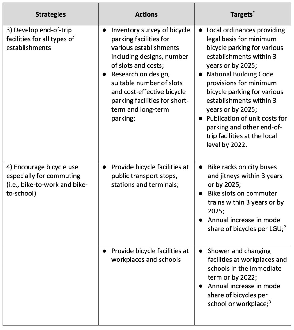
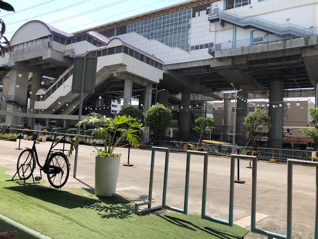
Bike parking at SM Masinag
With the increasing popularity of cycling, particularly the utilitarian kind (i.e., bike-to-work, bike-to-school, bike-to-shop, etc.), there is also the increasing need to provide facilities for cycling. Aside from the obvious (i.e., bike lanes), there are also what are termed as end-of-trip facilities, the most basic of which are parking. These may be spaces or slots allotted at workplaces, schools, markets, malls, government buildings, churches, etc. for cyclists or bikers to secure their vehicles. Bicycles may also be used as ‘last mile’ modes of transport so bike parking are necessary at transit or train stations. It is heartening to see the big malls like SM and Robinsons provide parking facilities for bicycles. Here are some photos of the bike station at SM City Masinag in Antipolo City.
 End of trip facilities in the Philippines is generally a work in progress. Hopefully, we get to benefit from their provision where they are needed – workplaces, schools, government buildings, commercial establishments, etc.
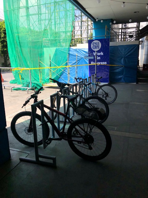
 The bike station at SM Masinag includes this bike repair stand with the basic tools for bike repairs and tire inflation.
 The bike station is just across from the Line 2 Antipolo Station (what was supposed to be called Masinag Station).
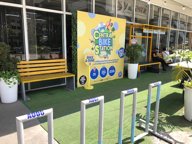 The central bike station also has benches for those who might want a rest and tables for those who want to “bike and dine”.
–
On bicycles vs. self driving cars
You’ve probably seen this graphic, the top part of which is attributed to the Cycling Promotion Fund. The last image is reproduced in the lower part of the image but labeled to emphasize what space is required to transport 48 people on electric cars and autonomous or self-driving cars.
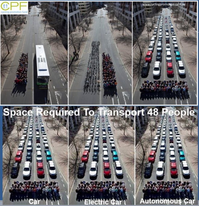
It is quite obvious that even if the current fleets of cars are replaced by electric and self-driving models, they will practically be the same problem in terms of road space occupied and the resulting congestion. So perhaps e-cars or autonomous cars are not really the solution we are looking for.
There is this nice article where the author articulates the how bikes (and active transport in general) should be the a more essential part of future transport and society than the automobile:
Collignon, N. (September 9, 2022) “Bikes, not self driving cars, are the technological gateway to urban progress,” Next City, https://nextcity.org/urbanist-news/bikes-not-self-driving-cars-are-the-technological-gateway-to-progress [Last accessed: 9/16/2022]
There are two quotable quotes from the article that I want to highlight here:
“Today the potential benefits from cycling on health, congestion, pollution and CO2 emissions are crystal clear and increasingly quantifiable, but the benefits of self-driving vehicles remain hazy. When ride-hailing companies like Uber and Lyft promised lower congestion and reduced car ownership, they instead increased congestion and led to a decline in transit ridership.”
and
“The concept of “jaywalking,” for example, is integral to the “car technology” of today. The crime of crossing a street without respecting the dominance of cars was invented by the car industry in the 1920s, who pushed hard to define streets as a place for cars, not people. Our car technology today is also defined by the restriction of movement it imposes on people.
When we begin to see technology through the lens of systems, it becomes clear that genuine technology-led progress will focus on dealing with the accelerating complexity of today’s world, not increasing the complexity of our tools.”
–
