
Home » Public Transport
Category Archives: Public Transport
Some thoughts on bus transportation for Metro Manila and beyond
There are two recent news items about buses in Metro Manila and adjacent areas:
- A proposed study on bus lanes for Quezon Avenue, Ortigas Avenue and C5
- Bus transport supplement for LRT Line 2
Did you know that there was a Pre-Feasibility for Bus Rapid Transit (BRT) along several thoroughfares in Metro Manila back in 2007? I am sharing this paper presented at the Transportation Science Society of the Philippines (TSSP) 2014 conference that synthesizes the references including the 2007 Pre-Feasibility Study on Bus Rapid Transit (BRT) for Metro Manila (supported by the USAID) and the 2011 Mega Manila Public Transportation Planning Support System (MMPTPSS) Study funded by the then DOTC. I hope these studies, which are still very relevant though no longer recent, can be utilized. There is no need to reinvent the proverbial wheel.
Sigua, R.G. (2014) “Identification of BRT Corridors in Metro Manila,” Proceedings of the 22nd Annual Conference of the Transportation Science Society of the Philippines, Iloilo City.
LRT Line 2 is an example of government not having the foresight of acquiring new rolling stock (i.e., trains) despite passenger demand steadily increasing over the years. Yet here we are and the old train sets are now deteriorating with some already retired. And then there is the proposal and study by the LTFRB and LRTA about buses supplementing the Line 2 operations. A quick check and there is already a bus service supplementing Line 1 – the Antipolo-Cubao route that is also serviced by jeepneys. This existing route can be tweaked or expanded so there are several lines serving not just Antipolo but also other Rizal towns and the City of Marikina. From Cubao there are already jeepney routes parallel to Line 2. Perhaps instead of just jeepneys, these can be rationalized to buses, which have higher capacities than PUJs? I don’t think you need to have a deep dive on this if you are familiar with public transportation along the Line 2 corridor.
–
Musings on a Sunday morning – on mode shift after railway projects are completed
A news article came out yesterday about the acting Secretary of Transportation stating that the number of vehicles on the roads will fall by 1 million once all railway projects are completed. I countered on my social media that he might just eat his words. Friends were more humorous in their comments including one saying that might just happen in the year 2100 (when we’ve all passed). Then, there are comments about this happening without railways, thanks to the escalation in fuel prices.
I wrote about my take on future rail use in the following article here back in 2019. There are others I’ve written earlier that were based on observations and research we have conducted the last 3 decades on transportation mode shares and the impacts of new railway lines.
While I would love to see people shifting from private vehicle use to public transportation (especially to rail), I am more grounded with my expectations. The Metro Manila Subway line will certainly be a game changer, and probably partly because it is not along any of the current corridors. It is unlike Lines 1, 2, 3 and the future 7 that are along corridors where they are or will be directly competing with existing road public transport modes. In the latter cases, people already taking public transport (road-based) would likely be the same people shifting to rail. As for the private transport users, they might just stick to their cars – unless, of course, they couldn’t afford the fuels or to acquire an electric or hybrid vehicle.
–
Bakit ma-traffic sa Ortigas Avenue? [Why is Ortigas Avenue congested?]
Bakit ma-traffic sa _______? I usually pose this question to my audience (e.g., students, trainees, etc.). In this post, I attempt to answer the question in the title using data we collected for Antipolo City’s Sustainable Urban Mobility Plan (SUMP). In one of the workshops, I asked the participants from the local government unit (i.e., from the various transport-related offices of Antipolo City) to try to determine the traffic mix for Ortigas Avenue Extension (also named Corazon Aquino Avenue from the Antipolo side) based on the traffic counts conducted at a station along the section that connected Antipolo with Taytay (at Tikling Junction). They also had performed vehicle occupancy counts along the same location so
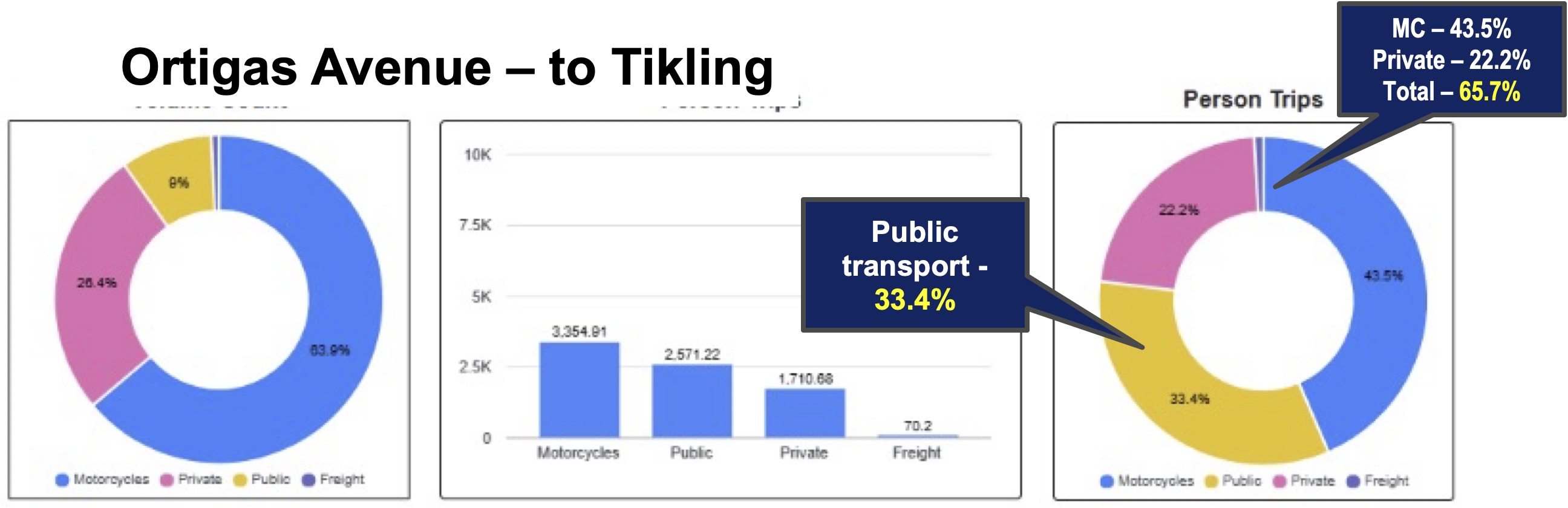
These are just the numbers from the Antipolo surveys. Note that Ortigas Avenue Extension serves as a collector for the Rizal towns including Taytay and Cainta as well as for Pasig City. If we have similar numbers for the traffic mix and occupancies, then we can conclude that most people are actually using private vehicles with a surprising share being carried by motorcycles! That seems to go against the narrative that private vehicle ownership is low and that most people take public transportation. At least for the case presented here, that is not true, and we seem to be underestimating private vehicle use or preference.
Next: Bakit ma-traffic sa Marcos Highway?
–
On transport strikes – are they still relevant or effective?
One of my students casually asked me about the effectiveness of transport strikes. I replied that while the strikes may and can raise awareness of the issues being protested, their effectiveness may have been diminished as people have become insensitive not just to them but to many of the issues we face these days. The latter includes the political mess we have that affects everyone regardless of who you side with.
Here is the series I wrote back in March 2023 – “A Brief History of Transport Strikes”:
Part 1: https://d0ctrine.com/2023/03/04/a-brief-history-of-transport-strikes-part-1/
Part 2: https://d0ctrine.com/2023/03/06/a-brief-history-of-transport-strikes-part-2-reasons-for-a-strike/
Part 3: https://d0ctrine.com/2023/03/08/a-brief-history-of-transport-strikes-part-3-advocacy-and-bandwagon/
And then this short piece in October of the same year:
What do you think?
–
Philippine Transportation Journal, Vol. 8, No. 1
The latest issue of the Philippine Transportation Journal is out. Volume 8, Number 1 includes five (5) papers derived from the Transportation Science Society’s 2025 conference held in December 2025. PTJ didn’t have a 2025 issue as last year was an EASTS Conference year and TSSP held its 31st Annual Conference in December instead of the usual September or October. Most if not all papers published in PTJ are from the best of the conference including the best paper and best presentation. Authors are given the chance to further refine their papers based on the feedback or comments in the conference sessions, which may be different from the comments received during the review process.
I reproduce below the list of papers in the latest PTJ issue. Three papers are associated with UP Diliman: #2 with the National College of Public Administration and Governance, #3 with the Asian Institute of Tourism, and #4 with the College of Engineering. One paper, #1 is from the University of Asia and the Pacific. The last but not the least, #5, is from UP Los Banos.
1. Empowering Local Government Units in Public Transport Service
Provision through Franchise Policy Reform – SUNIO, V., MANUEL, G., PACHECO, J.A.
2. Optimizing Route-based Fleet Size Computation through Network-Based Modeling for Puerto Princesa City, Philippines – Fajardo, A.C., SANCIANGCO, E., OLLERO, L.J., ALTEA, J.R., CASTILLO, C.A., TIGLAO, N.C., CUNANAN, P., SIPASIP, H.D., TOLENTINO, N.J.
3. Understanding Inland Water Transportation and Its Potential for Tourism: The Case of Navotas – Malabon River Boats in Metro Manila, Philippines – MASONG, G.R., AMIDAO, P.J.M., GUILLEN, M.D.V.
4. Measuring the Traffic Impacts of Tactical Urbanism: A Corridor and Intersection Analysis in Quezon City– MICIANO, M.L., HALIL, J., RAMILLANO, J., SIGUA, R.
5. Comparative Analysis of the Influence of Environmental Awareness on Transportation Mode Choice Between Students of UP Diliman and Ateneo de Manila University – SERIOSA, V.J., REYNOSO, C., LIM, M.B., SUNDO, M.
Here is the link to the PTJ Vol. 8, No. 1: https://ncts.upd.edu.ph/tssp/archives/3319
–
On preaching on public transport
I’m sharing this interesting article about a preacher who was asked to stop by commuters in a train in Sydney, Australia:
Why an Entire Sydney Train Turned Against an American Preacher
I suddenly remember similar instances when I was in high school and then as a university student. Some of the buses I rode on my commutes were boarded by preachers. I recall that people just didn’t mind them especially when they finished preaching and started asking for donations. I don’t remember anyone shouting or calling out the preacher to stop. Everyone was just silent and not minding the talk though I’m sure there were those who felt uncomfortable with the situation. Perhaps it’s just Filipinos being kind despite what may be regarded as an intrusion or disturbance. Fast forward to the present and there was a recent incident on a train where passengers made it clear they didn’t want to be evangelized in that way. That’s a complete reversal from my college days in the early 1990s. What do you think? Is a public transport vehicle such as a bus or train an appropriate venue for preaching? Or was/is there a violation of personal space here?
–
Commuting through floods
Yesterday’s rains were catastrophic. Reports stated that a week’s rains fell over a period of 2 to 5 hours, depending on where you were in the Mega Manila area. The resulting floods provided misery to people in flood-prone areas as well as those who had to go through the floods on their commutes to their homes. Here are photos from my commute going home yesterday. I relied on Waze for the shortest travel time and the app took me to flooded areas in Cainta. Perhaps it assumed my vehicle can safety navigate the floodwaters?
 Flooded street in Gruar Subdivision in Cainta, Rizal
 Flooded A. Bonifacio Avenue in Cainta, Rizal towards Taytay, Rizal. This is the main avenue through the heart of Cainta.
 Flooded streets in the area leading to Hunters ROTC Street. These residential areas are prone to flooding and children commonly play in the floodwaters – certainly at risk from getting sick from whatever it is in the waters.
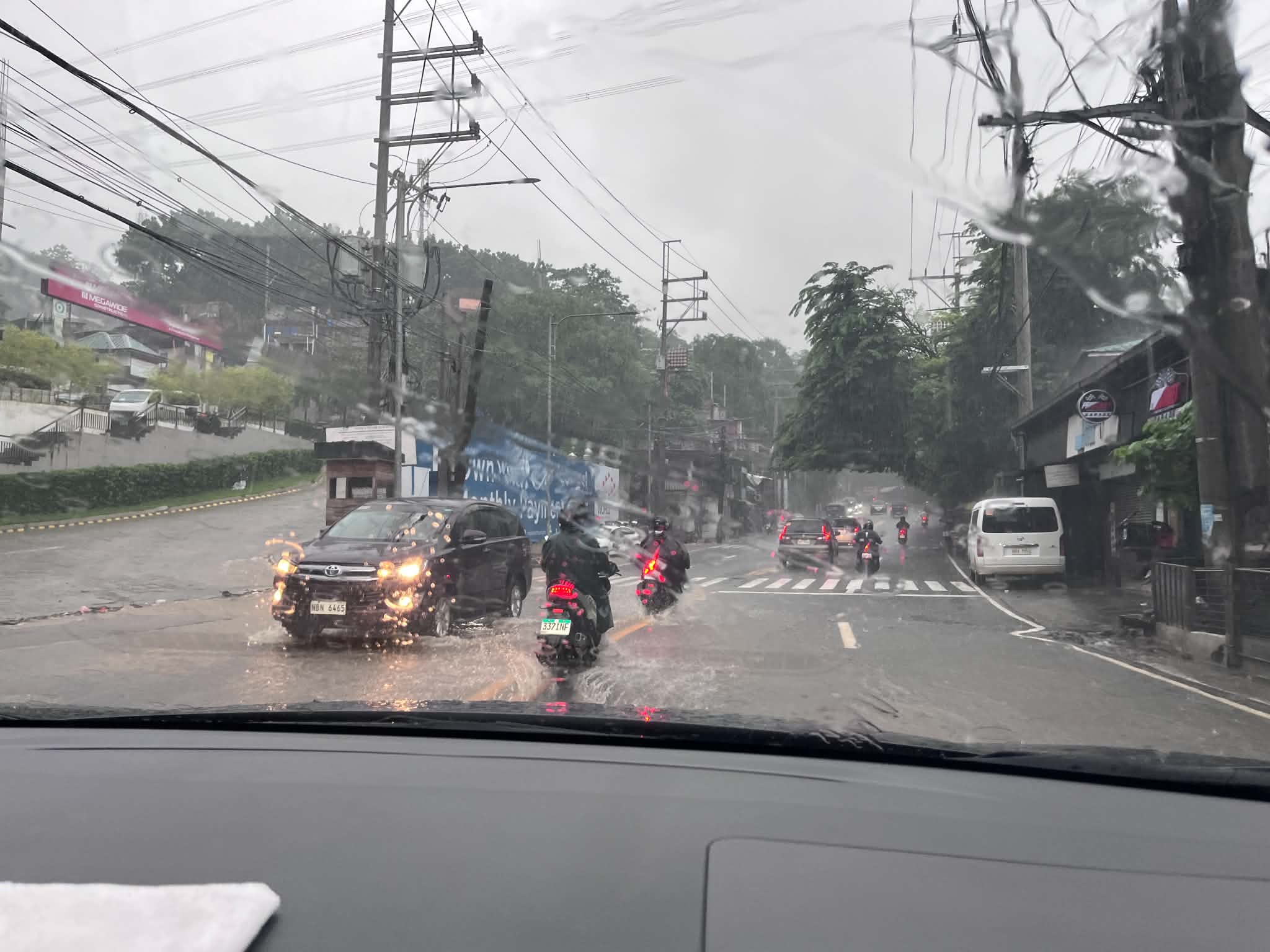 This is Ortigas Avenue Extension and on the way up to Antipolo. This area wasn’t flooded before and residents attribute the floods to the high-rise residential buildings and commercial development in the area. That’s actually a lot of run-off not absorbed by a drainage system that’s supposed to have been constructed with the developments. Did the local government of Taytay, Rizal make an evaluation of this before approving the projects?
Is there an end to this flood problem? Are the solutions really being implemented or, as we’ve learned the past so many months, are we being taken for a ride by our so-called leaders and agencies that are supposed to address these problems. People are supposed to be tired of the resilience story being peddled by politicians but the clamor seems to be in social media only and the real people who are lobbying for solutions have to contend with trolls who are also peddling their own narrative for their masters.
–
Article share – Planning for Love, Part 2: What happens to dating in a car-centric world?
I shared the first part of a series relating the built environment with love (or dating). The second part is also very interesting as it focuses on the impacts of car-centricity. To quote from the article:
“Everyone across both groups said they’d ideally like to meet their partner in person, organically, putting spontaneous public interactions and friends at the top of the list while dating apps and social media fell to the bottom.
In practice, however, drivers were getting far fewer spontaneous public encounters than they wanted, turning to social media for dating far more than they’d like.
For non-drivers, their actual dating life and dating ideals were much more in sync: public encounters and social media use both happened at nearly the rate they preferred. One exception was meeting through friends and family, which happened less often than they would’ve liked.”
Planning for Love, Part 2: What happens to dating in a car-centric world?
Source: Planning for Love, Part 2: What happens to dating in a car-centric world?
–
Travel time maps for Antipolo City
Yesterday, we facilitated a workshop for Antipolo City where technical staff of the city presented on the outcomes of various activities related to the formulation of a Sustainable Urban Mobility Plan (SUMP) for the city. One interesting output from one of the groups is this map showing the travel times within selected driving times with the destination being the Antipolo Shrine (“Antipolo Simbahan” if you will refer to the PUV signboards of those plying routes to Antipolo). The maps are the equivalent of travel time contour maps that can be generated with travel speed or travel time data.
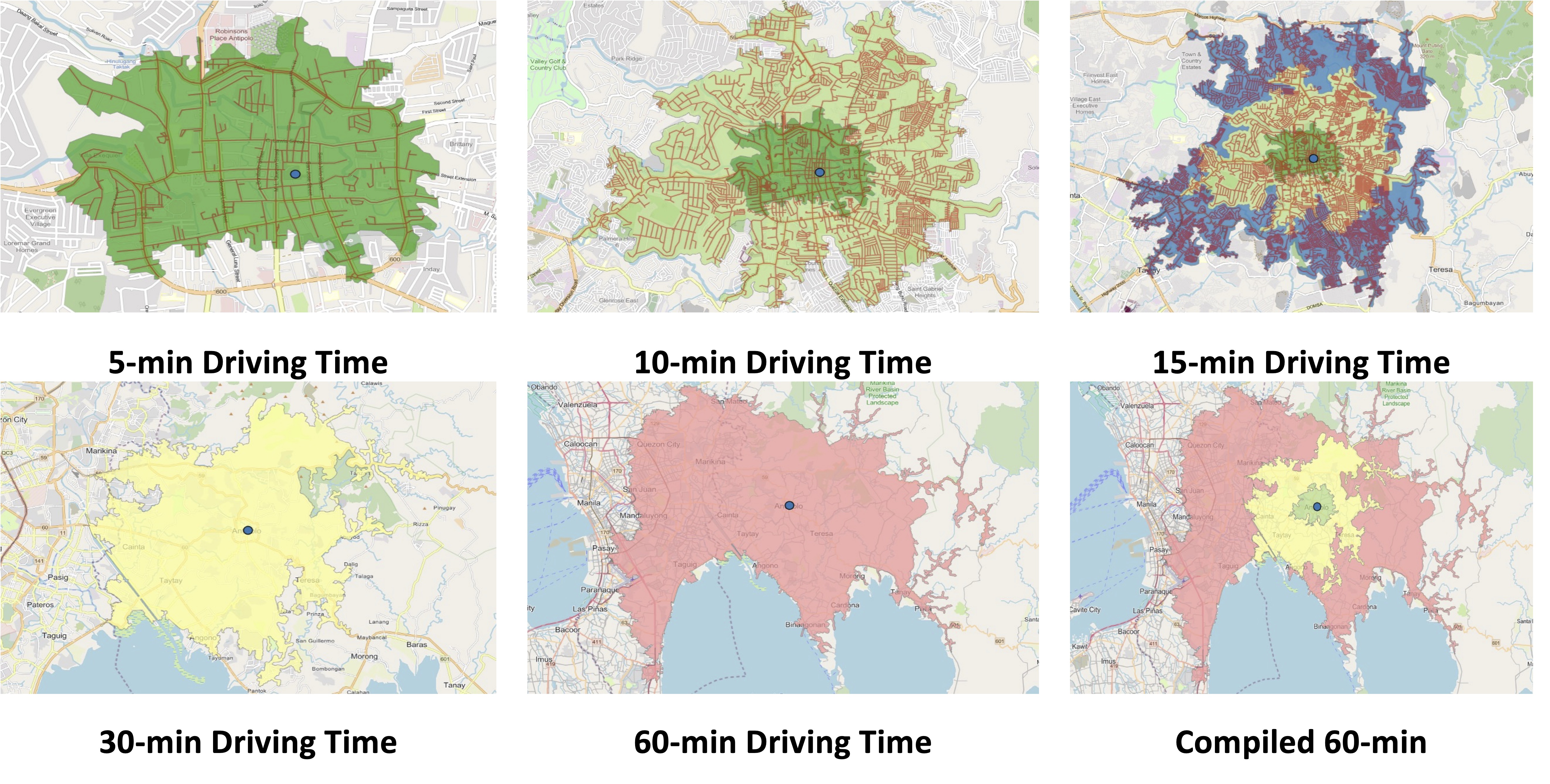
While shown are driving times and assuming car use, similar maps can be produced for public transportation, motorcycles, bicycles and even walking. It is just a matter of collecting the data and plotting them. Alternatively, the data can probably be obtained or derived from sources like Google Traffic or Waze. Some effort, of course, is required in order to have more accurate maps especially considering the road network and traffic circulation. Note that the travel times indicated are also centered on the Antipolo Shrine, which for presentation purposes was used to represent the center of the city. Other maps can be produced in aid of planning travel and transportation for the purposes of the city (e.g., how long it takes between Antipolo and Cubao for a regular commute, etc.).
–
Updates on the Katipunan jeepney terminal
Here are some photos I took while waiting for the green light
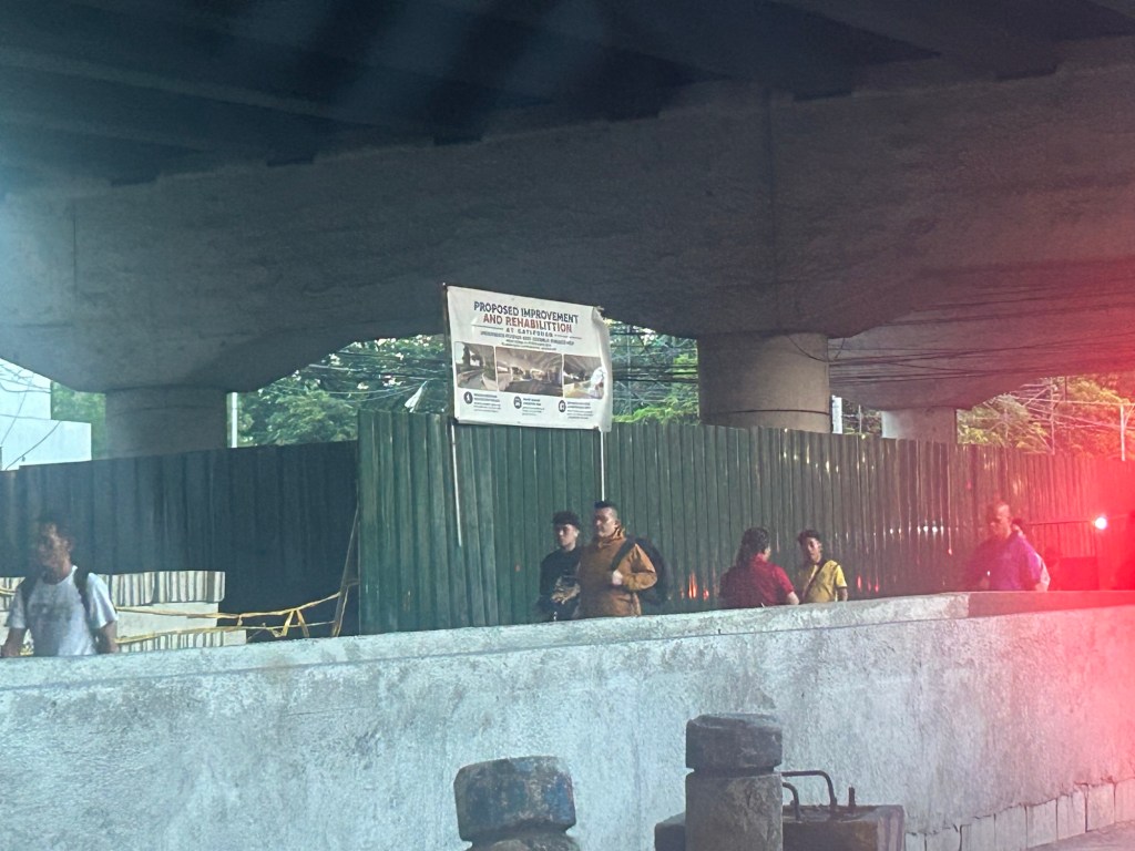
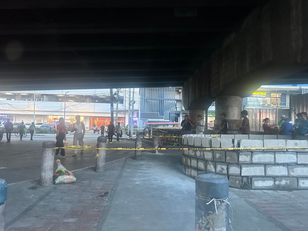
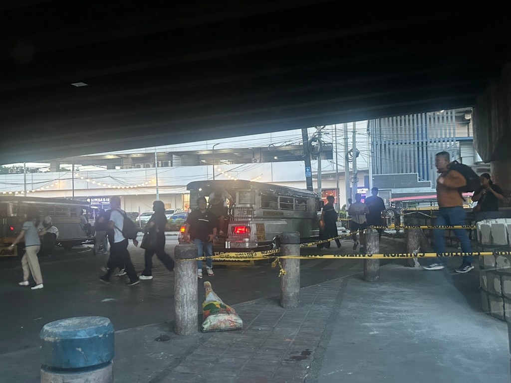
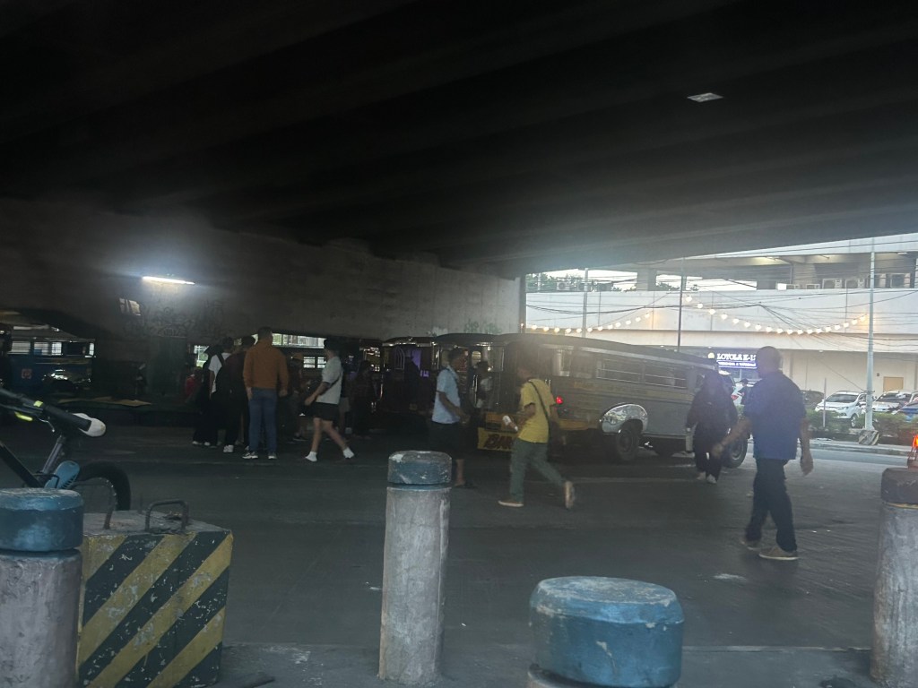
The bottom line is that the terminal will not be completely displaced. Jeepney parking spaces though have been reduced. I wonder where the other jeepneys spend their idle time considering not all Katipunan jeepneys are allowed entry to the UP Diliman campus.
–

