
Home » Road Safety (Page 5)
Category Archives: Road Safety
Back in Tagaytay
It’s been a while since I’ve been to Tagaytay. I think the last time was before the pandemic and with family. There used to be a time when we went there at least every month not counting the seminars and workshops we attended there. It was an easy drive from our home in Antipolo to Tagaytay via C6, SLEX and the Sta. Rosa-Tagaytay Road. We had our favorite stopovers with breakfasts usually at the Paseo de Sta. Rosa. Later, as Tagaytay became more crowded and congested, the trips became fewer. Of course, our schedules also became busier but then it wasn’t like we looked forward to the traffic and the crowded attractions there. I’m doing a project there now with my team at the office and that means I get to go there for work. Since we’ll be there anyway, we could have some side trips to eat some good meals (bulalo!) and maybe take some photos of Taal volcano.
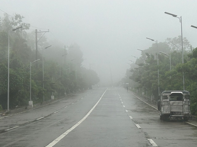
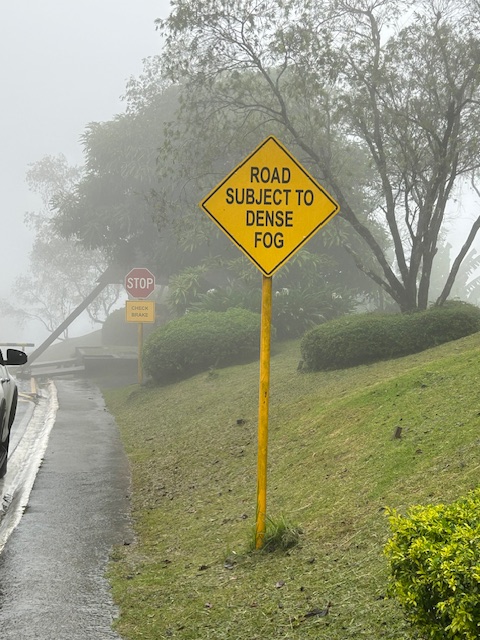
The fog was a quick reminder of the Tagaytay of old that we frequented before. But what we noticed was that it wasn’t cool. It was still somewhat warm if there was no breeze or wind blowing. This was certainly not smog as you can smell the pollution if it was. We even joked that it probably wasn’t because of the volcano as the smell of sulphur would probably be strong. We were in Tagaytay during the weekdays so there were fewer people and traffic. We were told that it was worse on weekends. That was to be expected. And with CALAX, Tagaytay became more accessible to visitors. I will write about the developments there in the next post. I feel there’s just too many buildings and the intense development has made Tagaytay less attractive. I have similar memories and feelings about Baguio but that’s another story to tell or write about.
–
Article share: Applying the New Traffic Safety Paradigm
Here is a quick share of an article on traffic safety from Todd Litman of the Victoria Transport Policy Institute. Source: Applying the New Traffic Safety Paradigm
In the article, the author discusses the use of ‘exposure’ as a measure of risk in as far as safety is concerned. The variable ‘vehicle miles traveled’ or in our case ‘vehicle kilometers traveled’ may be considered a risk factor. That is, higher or more VMT or VKT may lead to more crashes and casualties (and additionally damage to property). The objective is to reduce VMT or VKT in order to improve traffic safety.
To quote from the article:
“The new traffic safety paradigm recognizes the additional risk resulting from increases in low-risk vehicle travel and so favors strategies that reduce total vehicle-miles such as improved public transit services with free service for students, efficient school parking pricing to discourage driving, and more compact communities that reduce distances between homes and schools. In addition to reducing traffic risk these strategies also reduce household costs, traffic congestion and pollution problems making them win-win solutions. “
–
SPRINT principles for bicycles
Here is the link to how to improve your city’s or municipality’s bicycle facilities based on scores guided by the SPRINT principles: https://cityratings.peopleforbikes.org/create-great-places
SPRINT stands for:
S -Safe Speeds
P-Protected Bike Lanes
R-Reallocated Space
I-Intersection Treatments
N-Network Connections
T-Trusted Data
The site provides links and examples of good practices of actual bike projects in the US. Many of these can be replicated or adapted to Philippine conditions. These are something that the active transport section of the Department of Transportation (DOTr) should look into and perhaps provide a reference for developing and improving bicycle facilities in the country.
–
Article share: Planners’ Complicity in Excessive Traffic Deaths
Here is a recent article on safety and the involvement on traffic engineers from Todd Litman:
Source: Planners’ Complicity in Excessive Traffic Deaths
Let me note here about the interchangeability of the terms ‘traffic engineer’, ‘transportation engineer’ and ‘planner’. This is important to contextualize who is actually complicit or involved or responsible particularly in the Philippine setting. Too often and too quickly, traffic engineers or even civil engineers (in general) are blamed for traffic deaths or flaws in road designs. Disregarded is the fact that, as the article mentions, of the two major elements of travel – distance and speed – distance is often determined by the plans and designs of non-engineers. These are planners, or to be accurate land use planners, many of whom are architects by profession. We also want to differentiate between traffic engineers and highway engineers, who in the Philippine setting are actually quite different. One common thing about many of them is that they are slow to adopt progressive ideas or concepts of road planning and design such as complete streets and road diets. The outcome of this stubbornness is the specter of road crashes that lead to fatalities and serious injuries. But then they are not solely to blame or who should take responsibility for the atrocious road safety situation. The ‘distance’ component of travel is very much a product of land use planning and land development as practiced in our country. For many if not most developments, architects and planners are the ones who call the shots for the roads and transportation in the proposals. Traffic engineers are involved later and if not progressive complicates the situation regarding safety. Thankfully, some local government units are becoming progressive and are more mindful of development proposals including implications to road safety. Hopefully, many things will change among those involved so we can improve travel safety.
–
On the idea of congestion pricing
I purposely titled this post to include the word ‘idea’ as congestion pricing is still very much like that in the Philippines. It is a reality in some part of the world particularly in Singapore where its Electronic Road Pricing (ERP) has evolved and improved over the years. Its success though seems to be an exceptional case that has not been replicated elsewhere where conditions are not exactly like the city state’s.
Here is an article that recently came out from The Washington Post about the New York Governor’s decision to backtrack on the proposed congestion pricing initiative in New York City:
McArdle, M. (June 12, 2024) “People hate traffic. They also hate this great idea to clear it,” The Washington Post, https://www.washingtonpost.com/opinions/2024/06/12/congestion-pricing-great-idea-people-hate/ [Last accessed: 6/14/2024]
To quote from the article:
“Roads are a scarce good; you can fit only so many cars on a road at one time, and fewer if you would like those cars to go somewhere. When roads are “free,” we are forced to fall back on a more costly and inefficient strategy: sitting in traffic. This wastes valuable human time and inflicts noise and pollution on everyone nearby. Far better to charge a modest price that inspires some drivers to carpool and others to take public transit or shop nearer to home, until supply and demand are balanced and traffic flows easily…
In political disputes, a discrete group facing highly concentrated costs often defeats a larger public interest that conveys a small individual benefit to everybody — such as being able to move around the city faster when you really need to. This is particularly true in the American system, which is designed to empower angry minorities. And it’s especially true when they’re abetted by status quo bias and a sympathetic majority, as in this case.
Complain all you want about selfish suburban drivers or the Metropolitan Transit Authority’s bloated cost structure or Hochul’s cowardice; the biggest obstacle to congestion pricing is that almost two-thirds of New York City residents have told pollsters they oppose it — in a city where less than half of all households even own a car. A more technocratic, less democratically responsive government might have been able to ram it through, and perhaps in time everyone would have come to like it. But in fractious America, with all its political veto points, congestion pricing is doomed by the reality that people hate slapping prices on things — especially if they have to pay them.”
There is a congestion pricing proposal in Baguio City and we don’t know yet how this will go. I don’t have the details yet except that a private company whose core business is tollways is involved. Will this be a model or a proof of concept? Or will it just go the way of a typical tollway where users are those who are willing to pay and which would eventually congest if most of the current users pay and use it anyway? Will the funds generated be used to develop a more efficient transport system for Baguio, eventually leading and contributing to less congested streets? That would also mean eventually less revenues from the congestion pricing scheme and probably lead to it being unnecessary.
–
On the impact of bike lanes on motor vehicle traffic
With the news that bike lanes will be removed along major roads including, most recently, I share some findings from the US about a decrease in traffic speeds when there are protected bike lanes. The decrease in speeds are associated with a reduction in road crashes, ergo safer streets.
McPherson, K. (June 3, 2024) “Traffic Speeds Decrease When Bike Lane is Present,” Rutgers.edu, https://www.rutgers.edu/news/traffic-speeds-decrease-when-bike-lane-present [Last accessed: 6/8/2024]
To quote from the article:
“They found that the presence of the delineated bike lane made a difference: a 28 percent reduction in average maximum speeds and a 21 percent decrease in average speeds for vehicles turning right. For those heading straight and not turning, a smaller speed reduction of 8 percent was observed. In addition, drivers moving at a perpendicular angle to the bike lane did not slow down.
Marking the bike lanes with cones as a clearly delineated space was more effective at reducing speed than a painted-only bike lane. The painted-only bike lane was associated with a smaller speed reduction of between 11 percent and 15 percent, but only for drivers turning right.
Younes hypothesized that drivers slow down when they see a bike lane marked with the cones because the driving lane is narrower and requires more concentration, and it’s easier to notice cones or planters or some other space delineator than it is to spot painted lines on the road surface.”
Of course, one major element that was probably not considered in their studies is the presence and behavior of motorcycle riders. Motorcycles here frequently enter and use bike lanes whether protected or not. Often they crowd out bicycle users leading to situations where riders of motorized and non-motorized 2-wheelers come into conflict. Still, it would be nice to have a study to determine not just whether there are similar outcomes here but to what extent as well as how motorcycles figure in the study.
–
Safety or speed?
We start June by sharing a video on why safety and vehicle speed are incompatible:
I saw this video while browsing an article on “Dangerous by Design”. The article discusses a new publication where road designs are evaluated from the perspective of safety. Most of our roads have been designed with speed in mind. That is, how to facilitate the movement of motor vehicles to ensure they travel faster. Forgotten or, even worse, disregarded is the most important element of safety. Why do we widen roads or insist on higher speeds in populated areas or school zones? Such questions are not addressed directly or not answered at all by agencies in charge of planning, designing, constructing and maintaining roads and bridges. The same is true for agencies or units in charge of traffic regulations or management. The result not surprisingly is an increase in the number of road crashes, fatalities and injuries due to our roads being ‘dangerous by design’.
–
On non-roadway traffic deaths and incidents
I found this interesting article about non-roadway crashes or incidents that may cause deaths. These are often recorded in buildings including parking lots or facilities but are not generally collected and reported by governments as part of road crash data.
Wilson, K. (April 18, 2024) “Why Does the Vision Zero Movement Stop At the Edge of the Road?,” Streetsblog USA, https://usa.streetsblog.org/2024/04/18/why-does-the-vision-zero-movement-stop-at-the-edge-of-the-road [Last accessed: 4/28/2024]
From the article:
“According to the latest report from the National Highway Traffic Safety Administration, a shocking 3,990 people died in car crashes that occurred outside of the traditional transportation space in 2021, the last year for which data is available. One-quarter of those people were outside vehicles, including, pedestrians, cyclists, wheelchair users, and even children simply wishing their parents goodbye before they were accidentally run over by the caregivers who loved them most; all lost their lives after they were struck by drivers on private property, like parking lots, driveways, drive-thrus, and private roads.”
These crashes very likely contribute to under-reporting. One wonders, for example, how many incidents occur in mall parking lots, schools and subdivisions. Recall the incident in Ateneo years ago when a child got ran over and killed as students were being dropped off in the morning. Surely there are other incidents though not involving deaths, and these need to be recorded among traffic incidents. The deaths need to be included in the reports. These are important information to complete the picture of road traffic safety in any country including the Philippines.
–
Article share: on making more affordable neighborhoods
I’ve been commenting about how transportation cannot be isolated and the need to relate it to other factors such as housing or home location choice. The latter though is also affected by other factors as well that affect the affordability of homes near the city centers or CBDs where workplaces and schools are located. The result of course is sprawl or the encouragement of sprawl. Private companies take advantage of this or contribute to this ‘encouragement’ by developing land farther away from the center. Thus, for Metro Manila’s case, many people reside in the peripheral provinces of Bulacan, Rizal, Laguna and Cavite. There are even those who choose to reside in Pampanga, Bataan and Batangas.
Kayatekin, C.S. and Sanmiguel, L.U. (April 16, 2024) ” ‘Urban form’ and the housing crisis: can streets and buildings make a neighborhood more affordable?” The Conversation, https://theconversation.com/urban-form-and-the-housing-crisis-can-streets-and-buildings-make-a-neighbourhood-more-affordable-224108 [Last accessed: 4/23/2024]
Quoting from the article:
“Our main finding was that the bottom-up districts we looked at had, overall, more small-scale apartments. The reason is simple: they had more small-scale buildings, built on small-scale plots. Once divided into apartments, this produces small apartments – homes in the bottom-up areas were 10% to 23.1% smaller than their top-down counterparts. This also made their real estate markets for small homes more competitive, and therefore more affordable.
However, our study showed there is nothing inherently magical about bottom-up areas. Their more intricate housing stock has little to do with the layout of streets and blocks, and a lot to do with how that land is built upon.
Plot size appears to be the deciding factor: the districts with greater numbers of small buildings built on small plots supported a denser and more affordable housing stock, regardless of whether they were top-down or bottom-up.
Older bottom-up areas seem to naturally lend themselves to having more small-scale plots. This is likely due to the incremental development of these areas, and the complex land ownership patterns that developed as a result. However, there is no reason why a top-down area cannot be designed to replicate these characteristics.”
–
A risky mode choice – recumbent bike
I spotted this cyclist along Ortigas Avenue Extension. He would be hard to notice considering how low the vehicle is and his position astride the bicycle.
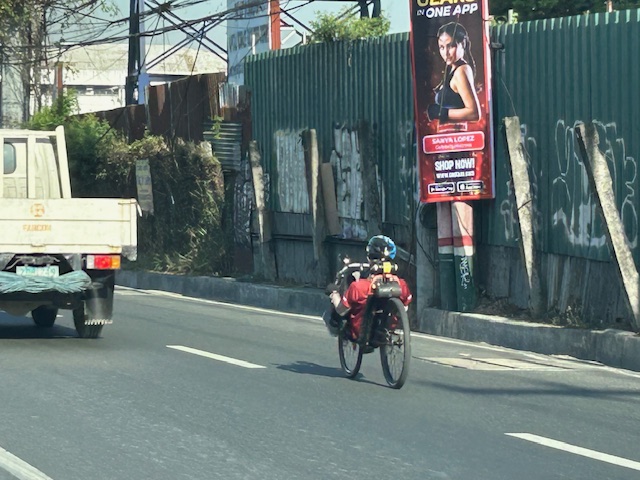 Man on a recumbent bike probably on his daily commute. Note the bike and its rider as compared with the small truck.
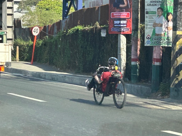
The problem is concerning his visibility to regular or typical road users. He might not be visible for the larger vehicles like trucks and buses, even jeepneys and vans whose drivers may be distracted by other vehicles in the traffic mix.
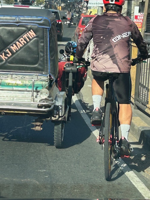 Comparison with a typical cyclist, who is quite visible as shown in the photo
–
