
Home » Traffic Engineering (Page 5)
Category Archives: Traffic Engineering
On Tikling Junction traffic (mis)management
There was an uproar among commuters when Taytay installed traffic signals at the rotunda at Tikling Junction. The junction is the intersection of Ortigas Avenue Extension, which continues towards Antipolo, the Manila East Road, which connects many of Rizal Province’s towns, and Leonard Wood Road, which leads mainly to residential areas in Taytay. There is another road that is close to the junction, Cabrera Road, that qualifies the intersection to be an offset type. However, vehicle coming in and out of Cabrera Road mainly are with respect to the Manila East Road.
 Traffic signals as seen from the Manila East Road approach to the rotunda
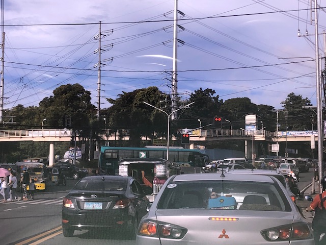 Traffic signals as seen from the Ortigas Ave. Ext. leg approach from Antipolo
The horrendous congestion last Thursday was due to the settings of the signals that forced most vehicles to stop even though there were movements that were not in direct conflict with others (e.g., through traffic along Ortigas Ave. Ext. from Antipolo towards the direction of Valley Golf/Cainta and right turning traffic from Ortigas Ave. Ext. to Manila East Road). The results were vehicles backed up all the way to Cainta Junction along Ortigas Avenue Extension and SM Taytay along the Manila East Road. We were able to experience the slight congestion the following day (Nov. 1) when we descended to Tikling from Antipolo. Congestion was slight probably because of the significantly reduced traffic due to the holidays.
I thought, based on experiences at this junction, that the traffic signal settings somewhat mimicked the style applied by Taytay traffic enforcers when they manually manage traffic at the intersection. Too often, they apply the “buhos” system where they try to let through all vehicles they see queued per approach. The outcome of this, of course, is longer stopped times to all other vehicles from the other legs resulting in longer and longer queues that become unmanageable especially during the peak hours (i.e., when vehicle arrivals are highest at the intersection). Basically, what happened last October 31 was that the “buhos” traffic enforcers were replaced by the machines (i.e., traffic signals) that employed the same system only this time there was no opportunity for some flexibility for movements that had none or the least conflicts at the intersection.
–
The Barkadahan Bridge situation
The Barkadahan Bridge is currently undergoing rehabilitation. To be accurate, the old bridge is being rehabilitated and upgraded/retrofitted to be able to carry the traffic projected to use it being a vital link between the Province of Rizal and Metro Manila via Pasig and the C-6 corridor. The bridge is named after the “friendship” established among Rizal municipalities and Pasig City for an area that has been subject of a territorial dispute among them. These are the municipalities of Cainta and Taytay (Rizal Province) and the city of Pasig. The bridge spans the Manggahan Floodway, much of which is in Pasig City.
To increase the capacity for this crossing, which is the most direct route to C-6 and popular among many headed to Taguig/BGC and Makati, a new bridge had been constructed to the south of the old one. The older one had 2 traffic lanes and was no longer sufficient for the volume of vehicles crossing it after the expansion of C-6 resulting to it steadily gaining more users over the years. Use of this route cut down travel times between Rizal and BGC and Makati by at least 30 minutes based on our experiences using the route.
Late last year as far as I could recall, the new bridge opened and immediately increased capacity but then congestion quickly set-in due to two factors: the traffic management at the intersection with the East Bank Road and the constrained (two-lane, two-way) leg of Highway 2000. Add to this the lack of discipline by local traffic in the form of tricycles and motorcycles counter-flowing in the area.
Earlier this year, signs were posted around Rizal about the then impending project for the rehabilitation of the old bridge. The signs advised for most travellers to avoid using the Barkadahan Bridge due to the congestion in the area because of the project. It turns out that what was thought by most as a project retrofitting the old bridge alone was actually a bigger one involving increasing the capacity of the Highway 2000 leg of the intersection with the East Bank Road. Following is a photo posted at the official Facebook page of the Rizal Provincial Government showing the demolition of buildings and other structures along the Highway 2000 leg. The photos were taken from the new Barkadahan Bridge approaching the intersection, the southbound direction of the East Bank Road, and from the westbound side of Highway 2000.
 Demolition and clearing of ROW for the expansion of Highway 2000 in relation to Barkadahan Bridge [Photo collage from the Lalawigan ng Rizal Facebook page]
From the photos above, it is clear that at least 2 lanes will be added to Highway 2000 and that this leg will soon be well-aligned with the Barkadahan Bridge, which will also have a total of 4 lanes. Hopefully, this project will be completed soon and within the year (before December?) in order to alleviate the commuting woes of Rizalenos working in the BGC and Makati CBD areas. Of course, that goes without saying that there is also a need to optimise the traffic signals at the intersection and to strictly enforce traffic rules and regulations vs. erring motorists in the area.
–
Alternate route via the Katipunan-Col. Bonny Serrano and C5-FVR Road intersection
I wrote previously about the alternate routes for eastbound vehicles given the ongoing rehabilitation of the Marcos Highway Bridge. In this post, I give some details on one alternative via C-5 and FVR Road (Riverbanks).
 The intersection of Katipunan Ave.-Col. Bonny Serrano Ave. now features a left turn signal for vehicles approaching from Blue Ridge. Previously, this was not allowed and vehicles would have had to go straight or take a right, and then make a U-turn if they wanted to head towards FVR Road. Otherwise, travellers would have to take the tunnel and make the U-turn at Eastwood.
 Vehicles queued along the C5 section approaching the intersection with FVR Road. The overpass in the photo is the section transitioning from the tunnel with an off-ramp past FVR Road.
 Vehicles approaching the now signalised C5-FVR Road intersection. Previously, too, this intersection did not have traffic signals. Vehicles coming down from Blue Ridge/White Plains could not go through to FVR Road but would have had to travel to the U-turn slot not far from here.
 The intersection of C5 and FVR Road – shown are vehicles turning from FVR Road to C5 southbound as well as those turning from C5 northbound to FVR Road.
–
On phantom traffic jams again
I’m sharing this article on phantom traffic jams:
Seibold, B. (2019) Traffic Ghost Hunting: When the biggest problem with traffic is nothing at all, Nautilus, https://medium.com/@NautilusMag/traffic-ghost-hunting-ac071197695d [Last accessed: 4/9/2019]
Have you wondered why the road or path is congested only to find out there seems to be nothing causing it? This is the phantom or ghost traffic jams caused by simple behaviours of travellers whether on motor vehicles, cycles or people like slowing down their movement or changing lanes. These disruptions cause a “ripple effect” on the traffic stream much as like waves are generated by a stimulus on calm waters.
–
On the efficiency of transportation – a crash course on transportation engineering concepts
There is an excellent article on the efficiency of transportation systems:
Gleave, J. (2019) Space/Time and Transport Planning, Transport Futures, https://transportfutures.co/space-time-and-transport-planning-1aae891194e5 [Last accessed: February 25, 2019].
It is highly recommended not just for academics (including students) but also for anyone interested in transportation and traffic. It’s like a crash course in transportation engineering with a lot of basic concepts in traffic engineering and traffic flow theory being presented for easy understanding by anyone. Enjoy!
–
On re-designing or re-imagining our transportation system for people
Here is another good read especially for those who advocate or even just beginning to appreciate the concept of people-oriented transportation:
VannPashak, J. (2018) “Design for humans as they are, not as you want them to be,” http://www.medium.com, https://medium.com/@jvannpashak/design-for-humans-as-they-are-not-as-you-want-them-to-be-ef95076c0988 [Last accessed: 11/23/2018].
In a recent symposium where I made a presentation about low carbon transport and visioning and re-imagining transport, I was asked how we can re-design our transportation to be more people-oriented than car-oriented. I replied that we have to do a lot of unlearning. That is, many planners and engineers would need to unlearn many things they’ve learned in school and those they got from their workplace. One convenient excuse for not coming up with a better design, for example, is that certain planners or engineers just followed what their offices or agencies have been doing. What if what their offices and agencies (and consequently their seniors at work) where wrong all these years and what was “ginagawa na” or “nakasanayan” have led to deficient outcomes? I even joked about whether these offices or agencies were “open minded” referring to a favourite by-line by networking companies. Being open-minded in the context of having people-oriented transport solutions would be difficult if everything was “nakakahon” because these were what you learned from school and/or the workplace. It is difficult to admit that something was and is wrong.
–
What the DPWH says about the installation of ads including those masquerading as signs
So what does the DPWH say about signs and their installation? The DPWH in their Highway Safety Design Standards (Part 2: Road Signs and Pavement Markings Manual) states the following:


It’s plain and simple and yet we find a proliferation of ads masquerading as signs and entities such as the MMDA and LGUs not properly (or strictly) implementing the provisions of the DPWH manual. It is also sad to see practitioners actively trying (and succeeding) to circumvent this provision in the DPWH manual.
–
More on ads masquerading as signs
I recently wrote about what I thought were ads masquerading as signs. It turns out a friend also took notice of similar signs along Katipunan and decided to make this a topic of his vlog. I learned that he has corresponded with the MMDA regarding this matter and even contacted the company behind these ads (I would prefer to call them what they really are.) to get their take on the matter. It turns out that the company is quite aware that what they are doing are basically not according to DPWH guidelines pertaining to signage. I wouldn’t and couldn’t say it is illegal since the MMDA and LGUs gave their approvals for these ads to be installed.
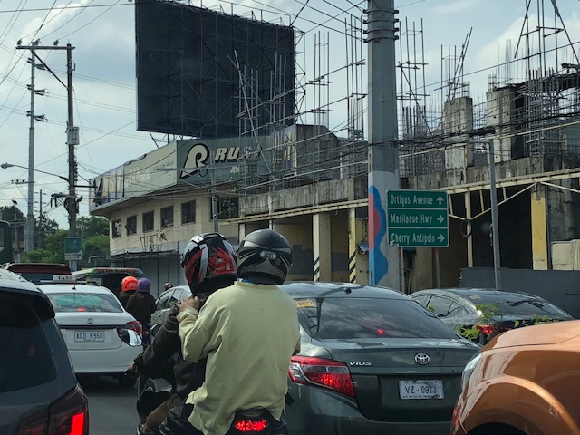 Approaching Cainta Junction from Antipolo, there is a sign that advertises Cherry Antipolo, which is all the way back and past Masinag Junction along Marcos Highway.
 Less than a kilometre away from Masinag Junction along Sumulong Highway, there’s another ad posing as a road sign and from a certain angle it covers a more important traffic advisory concerning the construction of the Line 2 Extension.
 This ad doesn’t even pretend anymore since all directions point to an Ayala Mall!
Following are examples of what may be tolerated and what must be disapproved and therefore removed. Guidelines are important so that the criteria for signs including ads masquerading as such will be clearly spelled out and approval/disapproval will not be
Logical: The photo below shows a sign installed by the DPWH showing the general directions for towns (Cainta, Taytay, Antipolo) or major thoroughfares (EDSA). The smaller sign is actually an ad for a mall but is located near a major junction (Cainta Junction – intersection of Ortigas Avenue Extension and Felix Avenue/A. Bonifacio Avenue) and may perhaps be tolerated as the mall is close by. Such a sign can be justified to assure or validate the direction to be taken by a traveler headed for this mall.

Not logical: The sign below is meters away from Masinag Junction in Antipol but advertises the same mall as the previous sign. It is not logical and should not have been approved since it is far from the destination mall and does not offer a validation or assurance for direction like the previous sign. In fact, the same mall chain has a branch nearby in the Masinag area and another one further on along the Marikina River. This sign should be removed as it adds to the clutter, the visual noise that makes people blind or numb to the actual road signs that require their attention.

[Disclaimer: For purposes of transparency, my colleagues and I also have worked as consultants for projects such as malls but never have we recommended for signs like these.]
–
On the opposition to “complete streets”
I recently read an article about the opposition to road diets in California, USA:
Tinoco, M. (2018) “How to Kill a Bike Lane”, http://www.citylab.com, https://www.citylab.com/transportation/2018/05/how-to-kill-a-bike-lane/559934/?utm_source=SFTwitter [Last accessed: 5/20/2018]
So far, we know that at least three cities are progressive enough to implement road diets including Marikina City, Pasig City and Quezon City. Iloilo doesn’t count yet since their bike lane was constructed along the very wide Diversion Road. Our recommendations for Tacloban, if implemented by the city, will probably result in the second most comprehensive application of road diets/complete streets in the Philippines after Marikina, which implemented their bikeways network almost 2 decades ago. There are sure to be many who would be opposed to such schemes as many still have the view that streets are for motor vehicles. This car-oriented thinking is something that will be a challenge to advocates of people-oriented transportation systems. Hopefully, many can learn from experiences here and abroad on how to reclaim space for people leading to safer and more inclusive transport for all.
–
On the Pasig HOV traffic experiment
Someone shared a post about a traffic scheme they will be implementing along Julia Vargas Avenue in Pasig City. The proposal is for the avenue to have a high occupancy vehicle (HOV) lane where vehicles with 4 or more occupants are to take one lane and all other vehicles the other. I am not entirely sure about the objective other than to promote high occupancies for vehicles. However, it would be nice to see how travellers will be behaving (e.g., complying) and how Pasig (with MMDA?) will be enforcing this scheme.
This is what a segment of Julia Vargas currently looks like with 2 wide lanes designated for motor vehicles (separated by the solid yellow line) and one narrow lane for cyclists (adjacent to the shoulder):
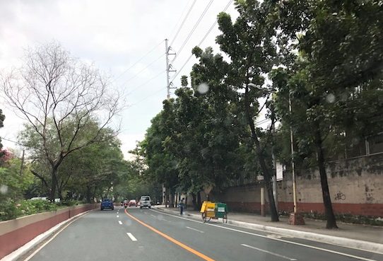
The intent is good but as a major link the scheme can be quite confusing especially for those who are not necessarily frequent users of this road. I assumed the yellow line was painted by the DPWH but it seems it was by Pasig. Perhaps they should have removed the old markings? Or maybe better if they rationalised the carriageway width to accommodate 3 lanes for motor vehicles and 1 wider lane for bicycles? From the photo above, it appears to me that it is possible to have 2 narrow lanes for general traffic and one wider lane for HOVs (in this case defined as having 4 or more occupants) and public utility vehicles. This configuration maximises the capacity of the road while having a the “best” lanes allocated for HOVs and bicycles.
I wish them success on this social experiment. Perhaps there can be valuable learnings from this including the need for connectivity to other links as well.
–

