
Home » Traffic Engineering (Page 7)
Category Archives: Traffic Engineering
Road crashes in Antipolo
I open June with a post on road safety. Last week, I passed by many road crash scenes along my route between my home in Antipolo and my office in Quezon City. Many were the now common crashes involving motorcycles. And there were those involving vehicles that got too close to each other in heavy traffic (e.g., tailgating vehicles eventually bumping the vehicle ahead of them). I was able to get photos of the site of the more serious crashes.
 Head on collision of a car and owner-type jeepney along Marcos Highway near the junction with Amb. Neri Road. These crashes are largely preventable if drivers kept to their lanes and refrained from violating the rule of the double yellow line separating opposing flows of traffic. I’ve written about counter flowing before but focused on it leading to traffic congestion. A more serious repercussion would be crashes like this.
 Overturned passenger jeepney along Marcos Highway in Mambugan, Antipolo. Speeding and unnecessary manoeuvres along this highway often has led to drivers losing control of their vehicles and, in this case, the vehicle turning over and likely hurting (hopefully not killing) passengers. This is again a very preventable crash considering it can be addressed by proper (read: safe) driving as well as enforcement.
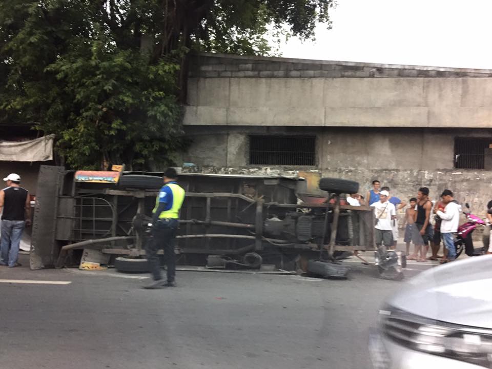
 Final ‘resting place’ of a truck that apparently lost control along the Tikling bound side of Ortigas Ave. Extension in Barangay Dolores, Taytay. I’ve noticed many breakdowns and crashes involving trucks along this highway as well as Sumulong Highway and Marcos Highway. Many, it seems, involve poor maintenance of these vehicles as well as overloading. Poorly maintained vehicles may lose control with or without their loads and lead to such crashes that in many cases are fatal to innocent bystanders.
With the onset of the rainy season, many roads will be slippery and this will tend to make them more dangerous. In the cases I mentioned above, most crashes are not the fault of the roads or the infrastructure but of the drivers and/or operators of the vehicles. Most crashes are preventable and are caused by driver error, negligence or aggressive behaviour. It is often the nut behind the wheel who is responsible for such crashes rather than the vehicle or the road.
–
Will a flyover at Katipunan-C.P. Garcia solve the traffic problem in the area?
I read a news article about the proposal by the Department of Public Works and Highways (DPWH) to construct a left-turn flyover at the intersection of Katipunan Avenue (C5) and C.P. Garcia Avenue in Quezon City. The flyover is supposed to be for vehicles turning left from the northbound side of Katipunan to C.P. Garcia Ave., which goes through the University of the Philippines Diliman
Will the flyover solve the traffic congestion problem in the area, particularly at the intersection and Katipunan in general? I would say no, it would not solve the congestion problem both for the intersection and for Katipunan. This assessment is due to the following reasons:
- The overpass does not address the root cause of congestion in the area, which is trip generation related. There are many major trip generators along Katipunan alone including three major schools (UP, Ateneo and Miriam) and a mall (UP Town Center). Add to this the traffic generated by the high density residential developments along Katipunan (notice the high rise condominiums lining up across Ateneo and Miriam?) and the through traffic coming from various areas that use C5’s Katipunan section.
- Congestion is caused by saturated intersections corresponding to Ateneo Gate 3 and main gate of Miriam College. Traffic going in and out of these schools are favored over through traffic along C5 resulting in congestion in the area. Perhaps it would be more appropriate to build overpasses to bypass these intersections.
- Congestion is caused by vehicles bound for and coming from the UP Town Center. The congestion due to traffic generated by the commercial development is actually alarming considering it is not yet completed and trips attracted and produced is not yet at full potential.
- The heaviest flows at the Katipunan-C.P. Garcia intersection are along Katipunan (northbound and southbound through traffic). Logic and traffic engineering principles point to grade separation to be more appropriate for such traffic and NOT for the left turn movement. A flyover should also be able to bypass UP Town Center as vehicles bound for the mall already blocks traffic along both sides of Katipunan and directly affects the intersection.
I think the DPWH should do well to re-assess their proposal along the lines of the reasons I have listed here rather than continue with the folly of building a left turn overpass alone. UP Diliman should also resist this overpass as, based on the news article, it would mean UP giving up some 8,000 square meters of its property for the project. UP already has given a lot for widening C.P. Garcia but that goes without saying that a through flyover might also require UP to give up property and particularly from its National Science Complex for such a project.
–
Some interesting (and required) readings on traffic engineering
Christmas breaks allow me to catch up on a lot of reading. The previous months comprising our university’s semester were spent preparing for lectures though I had to do some readings related to researches I am involved in. Browsing the net and social media, I came across 2 articles shared by an acquaintance. He is a very progressive planner who has extensively studied and written about the most relevant issues in urban planning, focusing on transport. A third article I found while reading one of the two. These were very interesting for me in part because they are thought provoking in as far as traffic engineering is concerned.
- What traffic engineers can learn from doctors
- As traffic deaths rise, blame engineering dogma
- The new science of traffic engineering
The author seems to call out traffic engineers in general but these articles should also be contextualized properly. The situations mentioned in the articles are to be found in cities in the United States and may not be applicable in other cities in other countries. Traffic engineers in Europe, for example, have been working on exactly the solutions being mentioned in the articles that would make streets inclusive and safe especially for pedestrians and cyclists. The same with Asian cities like Singapore and Tokyo.
In the Philippines, however, there is so much that we can learn from the articles. The mere mention of the design guidelines being used in the US betrays the flaws of highway and traffic engineering in the Philippines. The Philippines’ highway planning manual and other guidelines used by the Department of Public Works and Highways (DPWH) are heavily drawn from US references. Most highway and traffic engineers in the country are educated using curricula that use US textbooks and references. There are even civil engineering programs that use licensure exam review materials as their references! These exam materials are also known to be based on DPWH guidelines and manuals aside from problems “outsourced” or patterned after the Professional Engineer (PE) exams in the US. Few schools have progressive curricula that look to best practices that take into account the complexities of roads especially in the urban setting. Such ‘copying’ of American standards and practices in many cases do not consider Philippine (local) conditions and blind applications to our roads instead of proper adaptation often have lead to unsafe and inequitable roads.
–
Local papers presented at the EASTS 2015 conference – Mapua Institute of Technology
Mapua Institute of Technology (MIT) has a relatively young program under its School of Civil Engineering. This is led by their Dean, Dr Francis Aldrine Uy, who is also active with the Philippine Institute of Civil Engineers (PICE). Mapua has been aggressive the recent years in presenting and publishing papers in transportation engineering and planning. Following are the papers from the MIT:
- Integrated Non-Motorized Transportation System For A Sustainability Oriented Intramuros [Francis Aldrine Uy]
- A Study on the Effectiveness of Eco-Mobility Component: E-Jeepneys in Makati City [Francis Aldrine Uy]
- Comparative Study of the Effects of Fuel Sources (Diesel, Gasoline and Autogas) in Public Transportation in Metro Manila on Price, Emission and Health Issues [Francis Aldrine Uy]
- Determinants of Demands of Pasig River Ferry Service [Francis Aldrine Uy]
- Determination of Cost Impact using Mathematical Model Comprising City Logistics to Quick Service Restaurants in Metro Manila [Francis Aldrine Uy]
- Development of Evacuation Plan by Utilizing Transportation Modeling in the City of Borongan, Eastern Samar [Riches Bacero]
- Operational Performance Analysis of Median U-Turn Intersections as Traffic Control Facility in EDSA [Riches Bacero]
- Community Perception on Trans-operability of Intramuros [Riches Bacero]
- Paradigm Shift Strategy of Inclusive Mobility: The Applicability of Bus Rapid Transit along Commonwealth Avenue [Riches Bacero]
- Evaluation of Strontium Aluminate in Traffic Paint Pavement Marking for Rural and Unilluminated Roads [Riches Bacero]
- Study on the Impact of the Construction Activity of Skyway Stage 3 on Traffic Conditions along Osmeña Highway and San Andres Street [Geoffrey Cueto]
- A Design for Silver Star Integrated Green Bus Terminal [Geoffrey Cueto]
- Proposed Diversion Road to Improve Traffic Movement of Commercially Developed Areas in Bacoor, Cavite [Geoffrey Cueto]
- Establishing the City Logistic Concept in Improving the Freight Distribution in Metro Manila [Geoffrey Cueto]
- An Analysis on the Accessibility Level of Public Transit for Persons with Disability: In care of Light Rail Transit (LRT 1) [Geoffrey Cueto]
- Design and Development of the Puerto Princesa Airport Passenger Terminal [Jocelyn Buluran]
- Design and Development of Passenger Terminal at Batangas Port [Jocelyn Buluran]
- Design and Development of Passenger Terminal Extension of Clark International Airport [Jocelyn Buluran]
- Determinants of “Travel with Dignity” of Passengers of MRT3 [Jocelyn Buluran]
- Integrating Sustainable Non – Motorized Public Transport in the City of Manila, Philippines Through Analytic Hierarchy Process (AHP) [Jocelyn Buluran]
My only comment about certain papers in the list is that many do not seem to be research papers and definitely more on the practice (i.e., design) side than the academic. I can say this based on the presentations made that I was able to attend as well as the papers themselves in the proceedings of the conference that I was able to browse. Still, Mapua has very good potential to come up with good papers from the prolific Dr Uy and his young faculty members led by Engr. Riches Bacero.
The current President of Mapua, Dr Reynaldo Vea, is also the current President of the Transportation Science Society of the Philippines (TSSP). Dr Vea was formerly Dean of UP Diliman’s College of Engineering and Officer-in-charge of UP’s National Center for Transportation Studies (NCTS). His specialty is on maritime transport as he has a degree in naval architecture.
–
Presentations at Usad EDSA consultation, Sept. 24, 2015
Following are presentation materials from the Usad EDSA consultation held at the GT Toyota Asian Center Auditorium of UP Diliman yesterday. I assume these are all for public consumption and for sharing among all stakeholders (all of us traveling in Metro Manila whether we use EDSA or not).
Situationer and actions: 09242015 SRDA EDC_rev
DOTC Express Bus Project: DOTC – Final Expanding Express Bus Services–EDSA Decongestion 24 Sept 2015
DPWH Road Engineering Projects: DPWH
MMDA presentation of situation and data: MMDA-Katupunan Mtg
I will refrain from making comments in this post as I need to understand the contents of the materials first. The important thins is to note that the government is doing what seems to be a best effort given the constraint of resources and time (The Presidential elections are coming up in May 2016.). Everyone of us must pitch in and do our part in making our commutes more pleasant than what they are now.
–
EASTS 2015 – Cebu City, September 11-13, 2015
The 11th International Conference of the Eastern Asia Society for Transportation Studies (EASTS 2015) will be held in Cebu City this September 11-13, 2015. For information on the conference and program, check out their website here:
You can also download a brochure about EASTS here:
The conference is hosted by the Transportation Science Society of the Philippines (TSSP), which is the local affiliate of the EASTS. More information on the TSSP are found below:
–
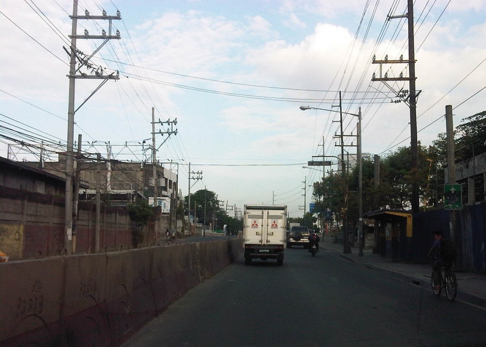
Ortigas Ave. Extension choke points
One alternative route for my daily commute is Ortigas Avenue. While there are several choke points along this road, I will focus on those between the Ever mall and Cainta Junction. Congestion is also usually experienced between the Manggahan Bridge and Ever but these are mostly due to traffic interruptions because of vehicles turning to and from the many subdivisions whose access/egress line up along Ortigas Ave.
The Ever mall is already a given as a significant traffic generator in the area. However, there is something about its circulation particularly the flow of vehicles in and out of the complex that detrimentally affects Ortigas Ave. traffic. While through traffic along the eastbound direction should use Ortigas Ave., many opt to go through the wide driveway of Ever in order to bypass the choke point that is the exit driveway of the mall. Many of these exiting vehicles are jeepneys turning left into Ortigas westbound (their routes terminate here and make their turnaround via Ever’s driveway). These effectively block the flow of traffic along Ortigas eastbound especially in cases when the westbound direction is also congested (i.e., due to sheer volume as well as stopping vehicles across the mall).
 Vehicles exiting from Ever and turning left to Ortigas westbound
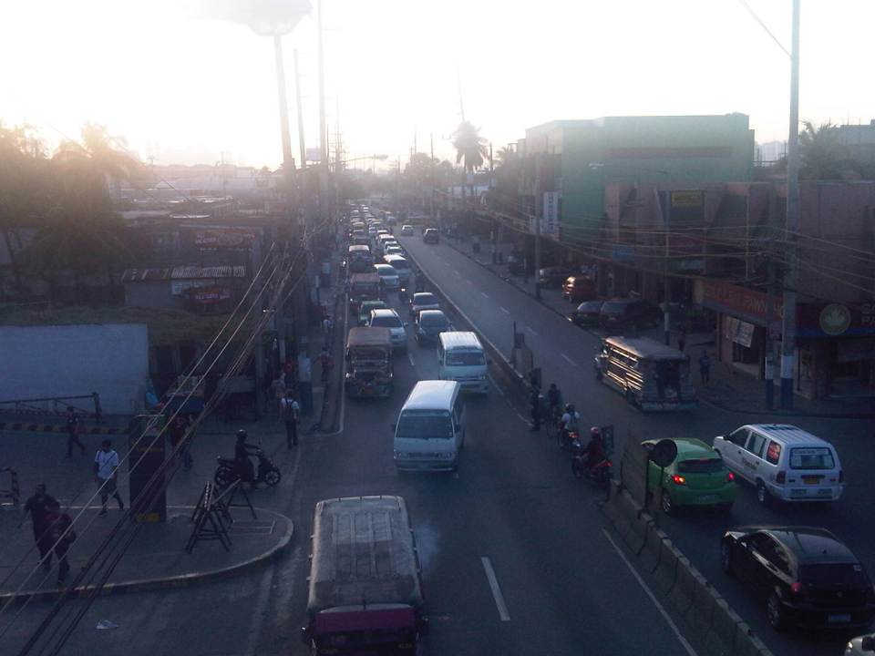
Once eastbound vehicles are freed from the blockage of left-turning vehicles, they have to merge with significant right-turning traffic from Ever that includes buses and mostly through traffic vehicles whose drivers were ‘wise’ to have taken the driveway instead of Ortigas to get through the choke point. The situation results in another choke point right after the first one as the traffic along two lanes of Ortigas eastbound merge with the traffic equivalent to 2-3 lanes turning right from Ever. The total of 5 lanes of traffic squeezing into 2 lanes immediately after is a prime example of a bottleneck.
 Narrow eastbound two-lane section – additional space should be expropriated to widen Ortigas at this section
Right after the short 2-lane section is a sudden widening of Ortigas Ave. in front of BF Metals. I have heard it said that this is the ideal road width for Ortigas Ave. considering the volume of traffic passing through this major corridor connecting Rizal province with Metro Manila. There are practically 4 lanes for each direction at this short section so its easy to project these lanes on maps to see what properties would need to be expropriated if the objective is road widening. (Of course, the best option should still be to pursue a mass transit system along this corridor.)
 Ideal road width – Ortigas Avenue at its widest is the section across BF Metals. Vehicles here spread out along the many lanes suddenly available. But then people will eventually and immediately realize this is the mouth of a funnel. Note the sign indicating that vehicles are entering the Province of Rizal from this point.
 The eastbound section in front of BF Metals is usually parking lot in the evenings. This is due mainly to the 4 lanes almost abruptly constricting into 2 lanes just past BF Metals. Compounding things is the U-turn slot located here where many jeepneys whose routes end at Cainta Junction make their turnaround. Turning vehicles are assisted by “tambays” earning their money by blocking eastbound vehicles to make way for U-turning vehicles.
Finally, there is Cainta Junction itself, which is a signalized 4-leg intersection that handles a tremendous volume of traffic all-day. I am sure that there are efforts for the traffic signal settings to be optimized but more often there is human intervention for traffic management at the intersection. Whether this causes more severe congestion is quite obvious to many travelers going through this intersection. Queues along Imelda Ave./Felix Ave., for example, can reach way past Village East even reaching Vista Verde on a bad day. This only shows that the intersection is already severely saturated and conventional traffic management or signal settings can no longer handle the traffic. Perhaps the next stage of engineering intervention for this intersection is grade separation or the construction of a flyover or two at the intersection. Notably, such a project should including strategic widening along Ortigas Ave in order to balance the number of lanes feeding into and receiving traffic from the intersection.
 A view of the traffic approaching Cainta junction – there are only 2 lanes along the eastbound side of Ortigas and public utility vehicles stopping here only exacerbates the congestion along the road.
Is road widening the ultimate solution to Ortigas Ave congestion? I personally don’t think so. As I have mentioned earlier in this post and in previous posts the key is still to come up with a mass transit system to serve this eastern corridor. Yes, there will eventually be a Line 2 along Marcos Highway, the main alternate (or competing?) route to Ortigas but is is obvious that even with a railway line along Marcos Highway and connecting to Aurora Blvd., there will still be an urgent need for a similar capacity line along Ortigas. The buses and jeepneys can no longer handle the demand and their poor levels and qualities of service have given rise to a proliferation of UV Express and pushed people to purchase cars and motorcycles. Congestion can be reduced significantly with a mass transit system along Ortigas. Without this transit system, Ortigas will just continue to be congested even if the entire corridor is widened; except perhaps if it is widened like Commonwealth Ave. in Quezon City. I don’t think that is possible and practical.
–
Undergraduate research topics on transportation for AY2014-2015
The Transportation Engineering Group (TEG) of the Institute of Civil Engineering (ICE) recently finalised the researches to be implemented by undergraduate students assigned to the group.
- Calibrating car-following and lane-changing models for local traffic micro-simulators
- Effects of clear yielding rules at weaving sections
- Evaluation of re-opening of traffic signals along Katipunan Avenue
- Shuttle service for University of the Philippines Diliman employees
- Analysing trip-cutting behaviour of jeepneys and UV express with respect tot he LRT Line 2 Santolan and Katipunan Stations
- Assessment of pedestrian facilities along Ortigas Avenue Extension and Marcos Highway
- Study on satellite parking system for UP Diliman
- Road safety audit checklist for expressways
- Study on Philippine National Railways (PNR) station congestion
- Using drones for analysis of weaving sections, and traffic circulation in roundabouts
- Air quality assessment at the Centennial Dormitory along C.P. Garcia Avenue
- Estimating bus passenger demand between UP Diliman and UP Los Banos
- Mode choice modelling of new transport systems
- On-road energy efficiency of alternative fuel vehicles
Note that several topics in the list are focused on issues concerning the UP Diliman campus. These are a continuation of studies geared at providing solutions to transport or traffic problems at UP’s flagship campus sprawled over an area of 493 hectares. The above are working titles at best as students taking up the topics are supposed to develop their research proposals (complete with literature review, methodology and budget) this semester and then implement these in the next semester. Since UP has already adjusted its academic calendar, research implementation will be undertaken from January to May 2015.
–
Lane discipline
Among many peoples’ pet peeves in traffic would probably be the propensity for lane changing among many drivers and riders. This is especially true for wide multi-lane roads like Commonwealth Ave., Marcos Highway and EDSA. While it can be an understandable behaviour for free flowing traffic along long stretches where weaving can be executed safely, lane changes can be quite risky at intersections and may instantly lead to crashes. These are likely the bases for the swerving violations that the MMDA and other traffic enforcers became notorious for issuing for a time.
We chanced upon a scene at the Commonwealth Ave.-Mindanao Ave. intersection in Novaliches where a car seemed to have attempted to cut in front of a bus in order to make a turn but got hit by the bus. From the angle of the collision, it appears that the driver of the car likely maneuvered for a U-turn and made the critical assumption that he could beat the bus for the turn. It was obvious that the bus was in the right position while the car was not. This is often the case for drivers who do not care for positioning themselves along the correct lanes at intersections and seem to rely on their guile to get ahead of others. Such drivers might just be the same ones who would likely do counter-flows also to get ahead of others queued along the right traffic lanes.
 White car attempts to make a U-turn right in front of a bus and gets hit by the bus whose driver likely did not notice the white car sneaking in front of the vehicle.
Lane discipline becomes more important with the revival of traffic signals all around Metro Manila. In addition, it is also important for the appropriate lane markings to be placed at intersection approaches. Such markings are supposed to guide drivers where they should position themselves so that they will not block traffic going in another direction. These can also aid in the enforcement of lane discipline as vehicles on the wrong lanes can be apprehended. This was the case in Cebu City in the 1990s when the city adopted the SCATS traffic signal system, which employed detectors embedded on the pavement along the approaches to intersections. These detectors helped determine whether there is demand for a particular movement (left, through or right) and so requires lane discipline for the system to work effectively. –
The return of traffic signals at Katipunan
It’s been more than a decade since the MMDA implemented what was formally called the Grand Rotunda Scheme. To most, it will always be the U-turn scheme that was implemented all around Metro Manila. After seeing what seemed like success along roads like Commonwealth and Quezon Avenue, it was concluded that the U-turns were the answer to Metro Manila’s traffic woes or at least the part that’s blamed on signalized intersections. The perception by many at the time was that traffic signals were not working and caused so much congestion as evidenced by the long queues at intersections. This is not entirely false as intersections with in-optimal settings would definitely bring about congestion especially along corridors or networks where signals are not coordinated. It was, however, a generalization at a large scale and led to more experiments of opening and closing slots in order to determine which would be the most effective combinations. These experiments and their outcomes include drivers becoming more aggressive in order to maneuver ahead of others at the U-turn slots. Weaving has become the norm and in many cases have increased the risk of road crashes.
 Traffic signals have been installed and the section of the median island has been removed across Ateneo’s Gate 3. This will become a three-leg intersections once again but I hope the signals will not favor Ateneo over through traffic along C5.
 Traffic lights are already installed along the southbound side of Katipunan at the approach to the junction with Miriam College’s Main Gate. This will be a four-leg intersection as across Miriam is B. Gonzales Street that connects to Esteban Abada.
The signals are supposed to be operational starting September 13, which is a Saturday. Perhaps this is to try it out first during that weekend and for the MMDA to do some tweaks before the real deal that is traffic on Monday. But then how can you simulate traffic generated by the two schools in the area except maybe if there is significant enough traffic on Saturday? Did the MMDA or its consultants do some simulation using their computers and the VISSIM software they acquired many years ago? Or will we see more of the experiments as signals are fine-tuned according to the conditions along Katipunan?
We are hopeful that the signals along Katipunan will help improve the traffic along this very busy corridor. The results for sections of C5 from Libis (QC) to Ugong (Pasig) are promising and many people I know have told me that traffic has improved. Of course, this may also be partly due to the one-lane policy the MMDA has implemented for trucks. It’s never just one scheme or measure that will work wonders for Metro Manila traffic. It will always be a combination that will alleviate traffic woes in the metropolis. We’ll soon know what will become of traffic along Katipunan. We should, however, temper expectations at least for the 6:30 – 7:30 AM period during weekdays when traffic peaks in the vicinity of Ateneo and Miriam. The sheer volume of vehicles generated by the schools will overwhelm any system that is put up in the area. Nevertheless, for the rest of the day at least traffic flow should improve when signals are operational once again for Katipunan.
–
