
Home » Traffic Management
Category Archives: Traffic Management
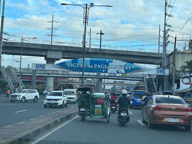
Ortigas Avenue Extension counterflow
One traffic scheme that has been constant along Ortigas Avenue Extension is the counterflow scheme. The scheme is applied in the mornings for westbound (outbound from Rizal) traffic. It has been implemented for as long as I can remember; perhaps since the early 1980s. One variant before was a form of “Buhos” where eastbound traffic is stopped for several minutes at certain intervals (6:30am, 7:00am, 7:30am and so on), and westbound traffic is allowed to take all the available lanes during the periods.
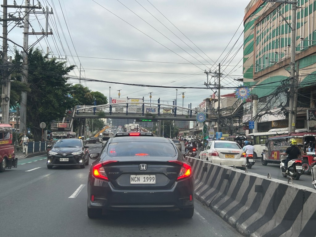
Considering this scheme has been implemented for more than 4 decades now, there must be some measure of effectiveness there. It is an example where the directional distribution during the peak hours allow for such scheme to be implemented. Note that the scheme pre dates number coding and similar counterflow schemes elsewhere in other major roads in Metro Manila (correct me if I’m wrong).
The scheme though only shows that there should have been a better transport system put in place along the corridor, which has had a steady growth in travel demand. There should have already been a transit line along this corridor a long time ago. What happened? Was it not in the government’s radar? There was a line proposed and shown in various master plans before.
–
On the chronic congestion along Ortigas Avenue Extension
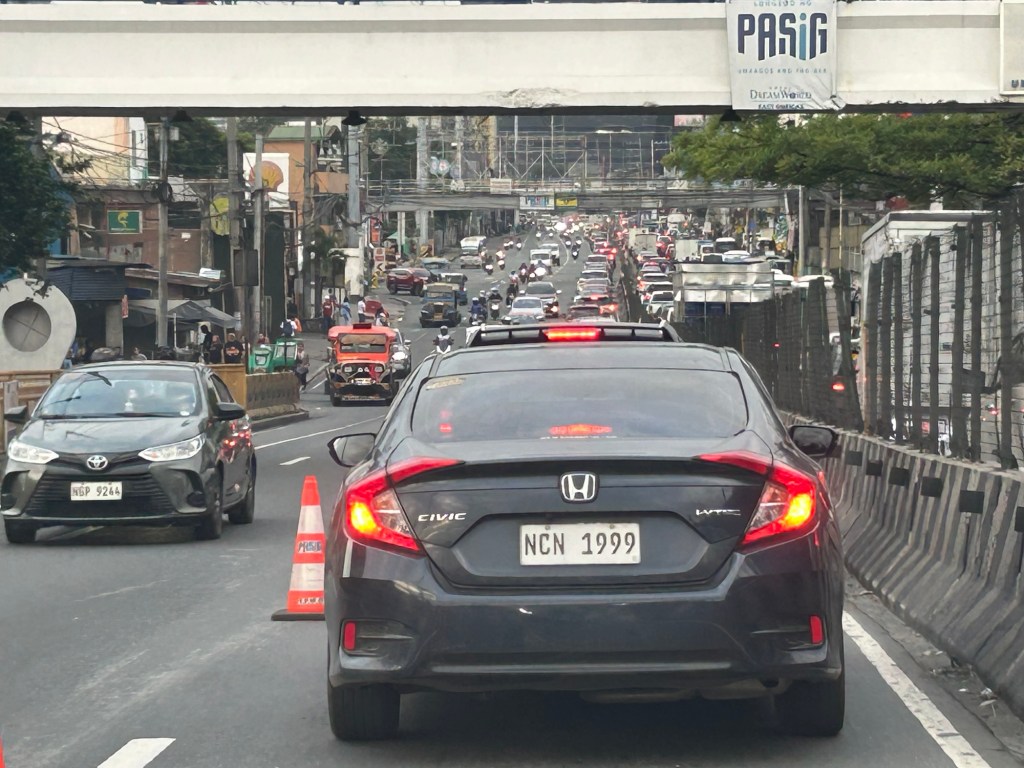
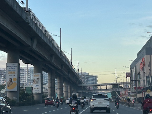
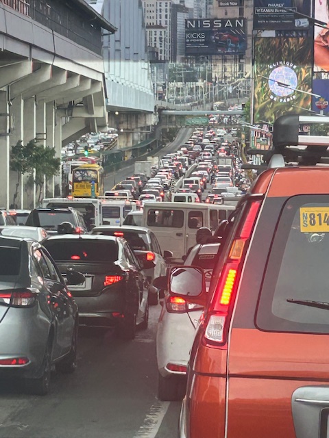
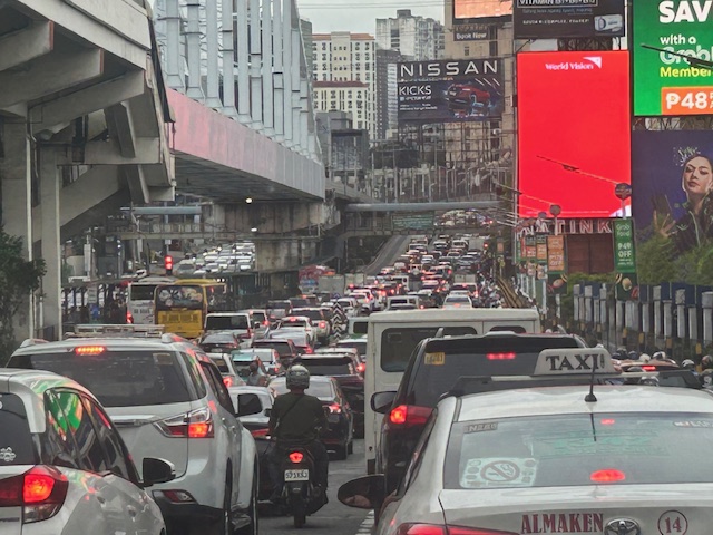
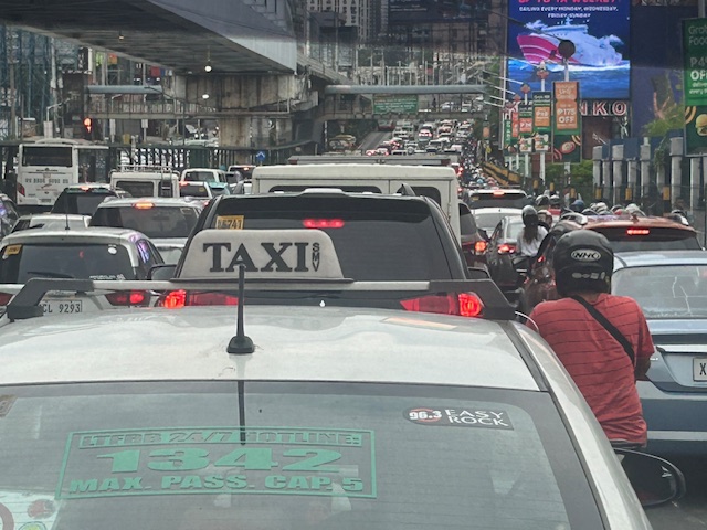
I previously wrote about the counterflow scheme along Ortigas Avenue Extension. While this is usually implemented during the mornings. A similar scheme is not applied in the afternoons or evenings. Apparently, the directional distribution in the afternoons and evenings is not suitable for a counterflow scheme. The photos below show the typical eastbound traffic as seen from the Manggahan Floodway bridge.
 Typical weekday evening traffic along Ortigas Avenue Extension
 The photos show that the traffic along the opposing direction (westbound) is as heavy as the eastbound traffic. This means a counterflow scheme similar to that in the mornings cannot be implemented during this period.
I have mentioned in the previous article that the corridor already required a mass transit system since the 1980s. Despite the operations of several bus companies over the past decades, these have not been enough (together with jeepneys and vans) to serve the demand along the corridor. It is not uncommon to find so many people stranded along the corridor and waiting to get a ride even during the early mornings. While Lines 2, 3 and 7 were being constructed, people in Rizal who have long endured the traffic along Ortigas Avenue Extension could only wonder why a transit system has not been provided for them. Will the proposed Line 4 be finally constructed? When will it be completed? What could be the traffic impacts of construction considering the limited space available for the construction? Should commuters prepare for more miserable travel once construction is underway?
–
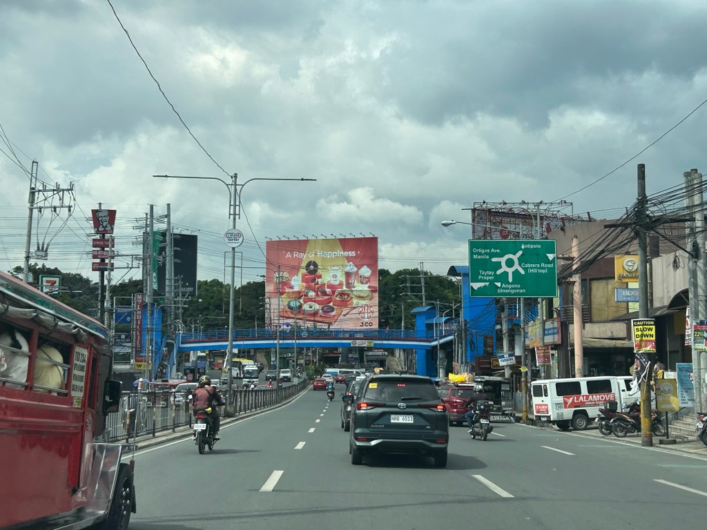
After getting engrossed with EDSA, is Marcos Highway next?
If you monitored the news articles and social media post over the past two decades, there seems to be an obsession for EDSA. Circumferential Road 4 is the busiest corridor in Metro Manila, stretching across several jurisdictions including Caloocan, Quezon City, Mandaluyong, Makati and Pasay City. Aside from the MMDA, national agencies like the DPWH and DOTr have been heavily involved in traffic schemes and transportation infrastructure development along the corridor. These include variants of the travel demand management (TDM) scheme commonly called number coding. Since the 1990s, there’s the Line 3 and several overpasses/flyovers and underpass that have been constructed along major intersections (e.g., EDSA-Shaw, EDSA-Ortigas, EDSA-Kamuning, EDSA-Quezon Avenue, etc.). Nowadays, people are more into the EDSA carousel and most recently the pavement rehabilitation for EDSA. It seems we failed to realize that EDSA is just one corridor. There are others that also demand attention including those in other parts of the country.
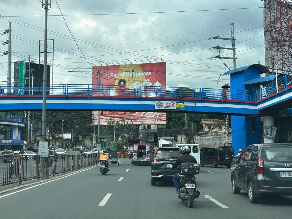
Recently, a “carmaggedon” along Marcos Highway was in the headlines or shall I say was trending in social media. There was a lot of excitement for what has been a recurring nightmare to those residing along the corridor. I recall something worse occurred more than 15 years ago (pre-Ondoy), before social media and influencers and digital creators. At the time, Line 2 terminated at Santolan Station. And even back then, the MMDA insisted on playing with their U-turn scheme. I don’t recall a more in-depth study that could have involved micro-simulation modeling being done for the corridor. And since then, populations and traffic have grown steadily and as I’ve written about previously, the extension of Line 2 to Masinag seems to have had little impact on traffic. And so here we are with the MMDA still insisting on tweaking their U-turn schemes and relying mainly on gut-feel instead of a more scientific approach that may actually lead to more sound solutions for the corridor.
 Approach to Marcos Highway from Felix Avenue – that’s the elevated Line 2 superstructure behind the Cainta arch.
 Intersection of Marcos Highway, Felix Avenue and Gil Fernando Avenue – there’s a major foot bridge installed here so people can cross at the intersection, which used to be a signalized junction before the MMDA opted for U-turns for Marcos Highway sections under its jurisdiction.
 Marcos Highway section fronting the Ayala Feliz Mall – the MMDA has played with the location of the U-turn slots in the vicinity of the Marcos Highway-Amang Rodriguez-J.P. Rizal intersection as they tried to determine the “optimum” locations of these slots.
Of course, there is also the case of Commonwealth Avenue. How many carmaggedons have occurred along that corridor? Isn’t it an everyday thing there? And there’s also Ortigas Avenue Extension and many other roads and streets where congestion seems to have been accepted as the norm. How do we make travel easier for most people? How do we improve commutes given the constraints and realities concerning behavior and choices?
–
Complicated intersections in Rizal – Tikling Junction
There are several major intersections in Rizal Province. Among them are 3 junctions in Cainta, Taytay and Antipolo – Cainta Junction (Ortigas Ave Ext.-Felix Ave), Masinag Junction (Marcos Highway-Sumulong Highway), and Tikling or Kaytikling Junction. The first two are signalized intersections. The last one is supposed to be a roundabout. All three are problematic in various ways and have been associated with congestion along the major roads intersecting at these junctions.
Tikling is quite interesting as traffic seems to have worsened after it was set up as a roundabout. Taytay enforcers have been deployed here but they seem to contribute more to worsening congestion rather than easing it. Motorists familiar with the area will tell you that traffic is better when there are no enforcers. Unfortunately, not all motorists here are from the area or are familiar with the rules for navigating or positioning at a roundabout. And so the intersection is often constricted with vehicles whose drivers and riders don’t practice courtesy.
Perhaps a combination of geometric improvements and more clever enforcement/management can improve intersection performance?
–
On roundabouts and how they can improve safety at intersections
Roundabouts are perhaps something that should be considered for Philippine roads. The concern, however, is that Philippine drivers don’t know how to navigate or position themselves in roundabouts. And the results as we have seen in several cases are congested roundabouts or rotundas.
AASHTO (September 26, 2025) “State DOTs Highlight How Roundabouts Improve Safety,” AASHTO Journal, https://aashtojournal.transportation.org/state-dots-highlight-how-roundabouts-improve-safety/%5BLast accessed: 10/19/2025]
To quote from the article:
“To highlight the safety benefits of roundabouts, the Ohio Department of Transportation recently released an analysis of crash data from 76 intersections statewide that had been converted to roundabouts. That analysis indicated single lane roundabouts decreased injury crashes by 69 percent while multi-lane roundabouts resulted in a 25 percent decline.”
And here another quotable from the same article:
“For us, it’s simple. Roundabouts remove cross-traffic turns and eliminate T-bone crashes, while improving traffic flow,” said PennDOT Secretary Mike Carroll …”“Any design that dramatically reduces the most serious crashes we see on the road is worthy of consideration in our projects.”
The article also includes a YouTube video on traffic circles.
–
Traffic congestion along EDSA
I’ve taken some photos of EDSA traffic as well as the EDSA Carousel buses. Here are the more recent EDSA photos I took as I traveled from Makati to Quezon City after serving as a panelist in the Energy Transitions Dialogue last Wednesday.
 I took this photo as we passed Guadalupe. I like this in the sense that it shows the clear ROW for the EDSA Carousel buses. One wonders why most of these motorists would prefer to drive their vehicles rather than take the bus or the MRT.
 You can see in the photo that EDSA’s northbound side is clogged as far as the eye could see. If you check the image under the MRT bridge, it shows the southbound side was also congested. These photos were taken around 4 PM so this was still an hour before most people would be going home from work.
 I mentioned in my comments at the panel that one consequence of giving number coding exemption to electric and hybrid vehicles is that this further diminishes the effectiveness (is it still effective?) of the MMDA’s number coding scheme. I don’t have the stats of how many EV’s and hybrids are registered and running in Metro Manila. Those numbers combined with actual counts will tell us how they are impacting traffic. That would be a nice topic for a paper. 🙂
The photos pretty much describe the transport situation in Metro Manila. Many of our major cities will be heading this way unless they improve their public transportation fast. If they do, then public transport mode share will be sustained if not increased. Metro Manila’s is already being eroded by inefficient public transport, motorcycles (including taxis) and perhaps unintentionally, electric and hybrid vehicles.
–
Is it possible to have zero traffic deaths in a year?
Is it possible to have zero traffic deaths in a year? Is it even probable? As it turns out, yes. Here’s an article on what Helsinki did in order to make this a reality:
Andrei, M. (August 1, 2025) “Helsinki went a full year without a traffic death. How did they do it?” ZME Science, https://www.zmescience.com/science/news-science/helsinki-went-a-full-year-without-a-traffic-death-how-did-they-do-it/ [Last accessed: 8/19/2025]
To quote from the article:
“A lot of factors contributed to this, but speed limits are one of the most important,” said Roni Utriainen, a traffic engineer with the city’s Urban Environment Division.
More than half of Helsinki’s streets have a speed limit of 30 km/h (approximately 20 mph). Half a century ago, the city barely had half of its area with a 50 km/h limit (30 mph). They gradually worked to reduce the speed limit, especially around schools and kindergartens.
Smarter street design also played a key role. Pedestrian and cycling infrastructure was prioritized for upgrades in recent years. More and more people started using public transit or bikes, or just walking. Substantial investments also made public transit more efficient and reliable.“Public transport in Helsinki is excellent, which reduces car use, and with it, the number of serious accidents,” Utriainen noted.
Another key component was bringing the police on board. Helsinki introduced automated traffic cameras and enforcement systems, which also helped bring down reckless driving.”
On the need to rethink traffic metrics
While Level of Service (LOS) criteria is a concept that can be applied to many other transportation facilities and aspects, among the LOS criteria that have been the subject of much criticism (and perhaps rightfully so especially in the context of safety) are the ones used for intersections. These are associated with delay reduction, which always favors vehicular throughput. The latter means basically, high LOS corresponds to prioritizing car (or motor vehicle) movement while not particularly taking into consideration the safety and movement needs of other road users (not using motor vehicles). Here is an interesting article on this matter:
Boenau, A. (July 9, 2025) “The old traffic math that keeps destroying neighborhoods,” Fast Company, https://www.fastcompany.com/91362348/road-design-traffic-math-destroying-neighborhoods-los [Last accessed: 7/15/2025]
Quoting from the article:
Here are three important questions for experts to ponder:
- Is slow-moving car traffic ever safer than fast-moving traffic?
- Do we have any obligation to provide safe and convenient access for people when they aren’t inside cars?
- What are the economic downsides of wider, faster streets in the central business district?
When planners and engineers truly wrestle with those questions, they can choose to remain a conformist who ignores the damage of traffic metrics, or become an outlier in the industry and make a positive impact that might be felt for generations to come. Things can get better in the end.
–
Again, I must say that rethinking roads and streets should be context sensitive. Still, safety should be the top concern especially for areas that is predominantly residential and/or school. Safety, after all, comes first in the definitions of transportation and traffic engineering.
–
Quick comments on the NCAP
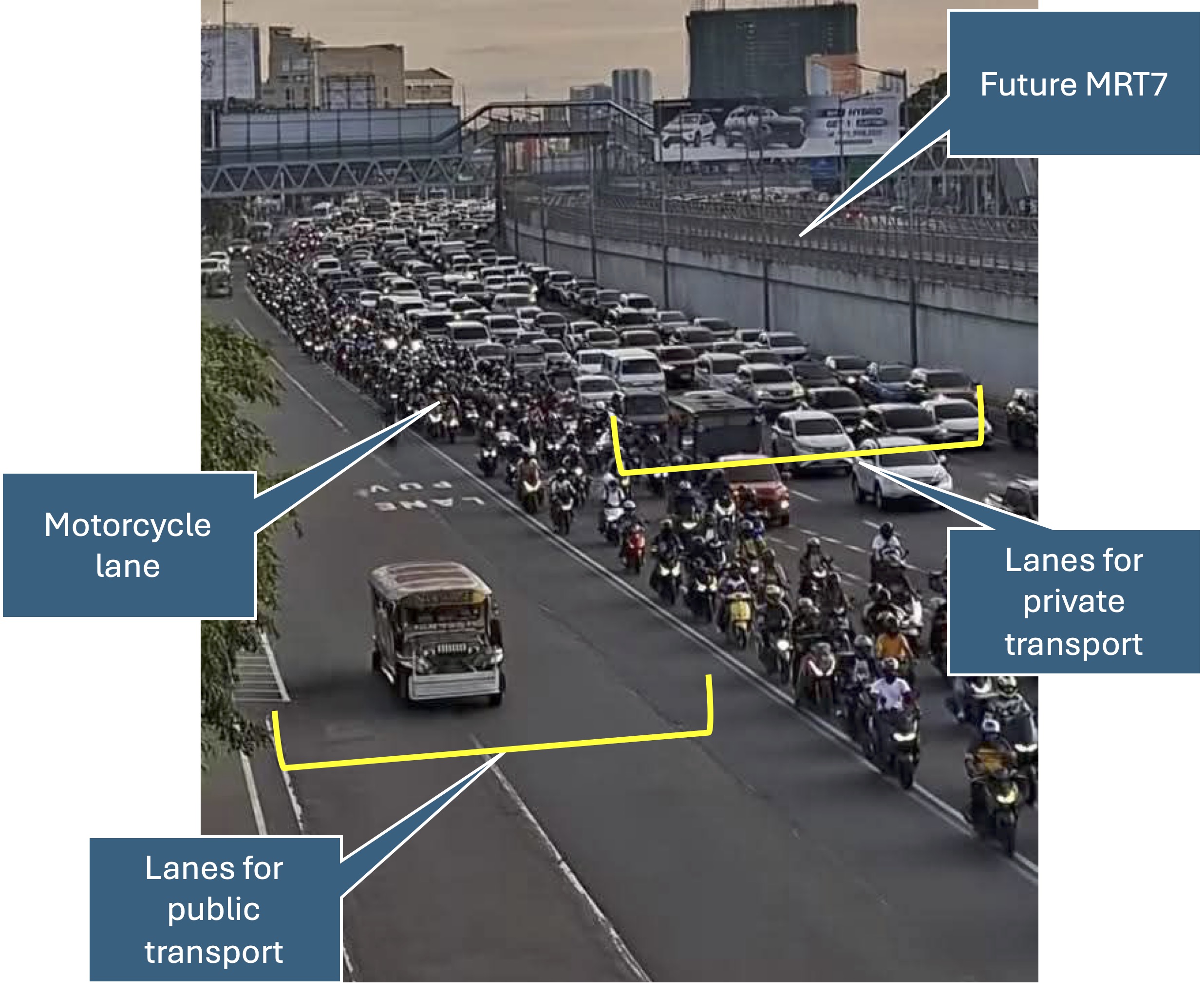
The No Contact Apprehension Policy (NCAP) is finally being implemented in Metro Manila. The results so far has been dramatic in terms of the number of violations recorded and the images being shared so far about how motorists are behaving. Below is one of those photos being shared on social media to which I added some annotations. I will use this later to comment on the NCAP and how we can use the outcomes to assess the transportation situation and determine what interventions can be done. Some are already obvious from the photo – the lack of public transport options lead to people depending on private motor vehicles like cars and motorcycles for their commutes. MRT7 is yet to be operational and road public transport has not been rationalized.
More on this topic soon!
–
On transportation problems being treated like diseases
I am sharing this relatively old article on transportation problems needing treatments as if these were diseases. I say it’s ‘old’ because it’s from last year, and these days when much content is being pushed everywhere including mainstream and social media, things get old, quickly. Rewind to more than a decade ago and Intelligent Transportation Systems (ITS) wasn’t as popularly applied as today and Artificial Intelligence (AI) seems to be everywhere now including in transportation systems.
Menard, T. (September 1, 2024) “Transportation Rx: Treating Traffic Glut Like Doctors Treat Sinus Congestion,” Planetizen, https://www.planetizen.com/features/131478-transportation-rx-treating-traffic-glut-doctors-treat-sinus-congestion [Last accessed: 4/21/2025]
To quote from the article:
“Traffic congestion is not unlike congestion that builds up in the human airways. When we see a doctor, we are prescribed a treatment that clears the backup. Similarly for roads, rather than setting up road signs and cones to redirect traffic, cities can take a more prescribed treatment approach through methods such as congestion pricing and other road pricing strategies, as well as technologies like edge computing, navigation-enabled Mobility-as-a-Service (MaaS) modeling, and transit signal prioritization. “
This is not the first article to allude to medicine when the topic is traffic congestion. There are others that use terminology from the human body’s circulatory system. When an artery gets blocked, a bypass can be a solution. But perhaps we don’t need bypasses and look at other. more effective ways of dealing with transportation problems.
–
