
Home » Traffic Management (Page 7)
Category Archives: Traffic Management
On the impacts of the closure of the Marcos Highway Bridge
The Marcos Highway Bridge was scheduled for rehabilitation in the next four months starting last week. While it will not be totally closed to traffic, the scheme reducing its capacity will surely lead to congestion along Marcos Highway. This congestion should be expected along other roads as well, as travellers, particularly those taking private transport will be using alternative routes in order to avoid this area. Those coming from the east will likely go through Marikina City via the parallel route comprised of Sumulong Highway and A. Bonifacio Avenue. Others will turn to A. Rodriguez (Ligaya). And perhaps others may go via Ortigas Avenue Extension. These alternative routes correspond to the other bridges crossing the Marikina River connecting the Rizal province and part of Marikina and Pasig to Metro Manila.
 A photo of the bridge prior to its partial closure
I will write more on this topic once I get more information on what’s happening to the traffic in the area. Meanwhile, I do know that my usual alternative route via Marikina and Tumana seems to have more than the usual traffic during my commute. While it is easy to attribute this to the partial closure of the Marcos Highway bridge, this could also be just a normal variation in the typical daily traffic for that route.
–
Bike patrol
Wouldn’t it be healthier and more effective for law enforcers to have bike patrols? Many of them seem to be detached from the communities they’re supposed to serve when they aren’t on foot or pedals but instead go around on motor vehicles. It also seems a waste that the motor vehicles assigned to these people are being used to train them for driving. Thus, you often see patrol cars (even motorcycles) that are supposed to be recent model vehicles but seem so battered already. Do they really use these for chases? Or are they damaged due to their being used as “training” vehicles?
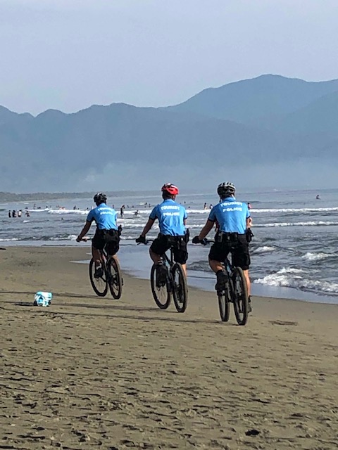 PNP officers on bike patrol along the beaches in Baler, Aurora
To be more effective, police officers should probably be roaming on foot or bicycles. They can be more in touch with the communities as there will be opportunities to mingle compared to if they were on cars or motorcycles. In one thread on social media, for example, there was a call for our local police to adopt the “Koban” style of the Japanese police where officers roam the communities mainly on foot and where many are recruited from the community for the latter and former to have some familiarity with the people and areas they are assigned to. Going around on foot or bicycle would also be a healthier option as surely they will be able to go more than the 10,000 steps (or equivalent) necessary to be classified as active.
–
On phantom traffic jams again
I’m sharing this article on phantom traffic jams:
Seibold, B. (2019) Traffic Ghost Hunting: When the biggest problem with traffic is nothing at all, Nautilus, https://medium.com/@NautilusMag/traffic-ghost-hunting-ac071197695d [Last accessed: 4/9/2019]
Have you wondered why the road or path is congested only to find out there seems to be nothing causing it? This is the phantom or ghost traffic jams caused by simple behaviours of travellers whether on motor vehicles, cycles or people like slowing down their movement or changing lanes. These disruptions cause a “ripple effect” on the traffic stream much as like waves are generated by a stimulus on calm waters.
–
On the traffic flow predicament at Tikling junction…again
During weekends, a constant frustration have been the incidence of severe traffic congestion along Ortigas Avenue Extension. Weekday evenings are usually better in terms of traffic compared to Saturdays. But last Monday, the congestion was so severe the congestion reached Valley Golf and vehicles had to crawl to Tikling. As mentioned in previous posts on this subject, part of the problem is the sheer volume of vehicles that make the roundabout set-up inappropriate for the junction. Then there is also the issue about the people who are supposed to manage traffic but end up mismanaging it. From what I usually observe, they tend to favour vehicles coming from Taytay via the Manila East Road leg and seem oblivious to the build-up of traffic along Ortigas Ave. Ext. eastbound.
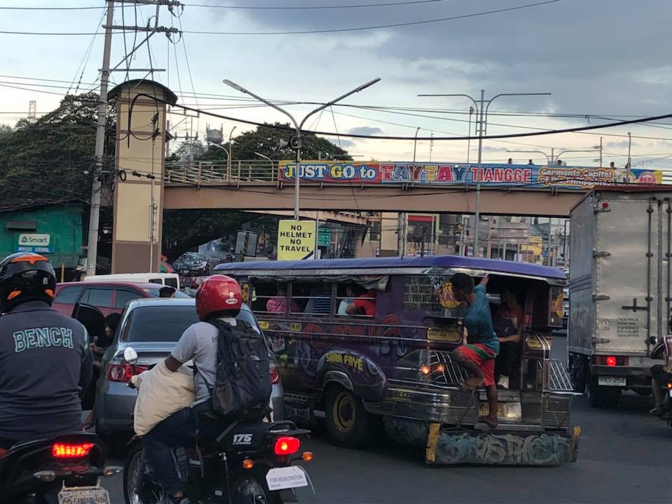 Typical heavy traffic at Tikling Junction
We might finally get a chance to have a solution for this. One of our students took on a topic that will require her to asses the traffic at the intersection to determine, for example, whether the roundabout is suitable or perhaps should be changed into a signalised traffic control. Both analytical approach and microsimulation (using Vissim or the homegrown LocalSim) will be employed. But we will have to wait by May to see some substantial results.
–
On computer games for city planning
There’s another article on a very popular computer game that allows people to play city planner or mayor. I recall playing the game for the first time in the early 1990s. A friend got hold of a bootleg copy of the first version and we soon found ourselves addicted to the game. 🙂
Roy, J. (2019) From video game to day job: How ‘SimCity’ inspired a generation of city planners, Los Angeles Times, https://www.latimes.com/business/technology/la-fi-tn-simcity-inspired-urban-planners-20190305-story.html [Last accessed: 03/13/2019]
Of course, later on we tried experimenting on some concepts to see how the game will go for themes such as transit oriented development (TOD) and combinations of land uses. This allowed us to have an appreciation of how a city will grow and how networks perform given various scenarios. I still believe the game has a lot of value not just from the gaming perspective but also from an academic or practical view. City planning (and not just the transportation or traffic aspect) is a very complicated matter and requires a lot of know-how, wisdom and logic (also others) for a city to function well and for it to grow. Perhaps the newer versions of the game will be even more “realistic” and help develop future planners and administrators.
–
On re-designing or re-imagining our transportation system for people
Here is another good read especially for those who advocate or even just beginning to appreciate the concept of people-oriented transportation:
VannPashak, J. (2018) “Design for humans as they are, not as you want them to be,” http://www.medium.com, https://medium.com/@jvannpashak/design-for-humans-as-they-are-not-as-you-want-them-to-be-ef95076c0988 [Last accessed: 11/23/2018].
In a recent symposium where I made a presentation about low carbon transport and visioning and re-imagining transport, I was asked how we can re-design our transportation to be more people-oriented than car-oriented. I replied that we have to do a lot of unlearning. That is, many planners and engineers would need to unlearn many things they’ve learned in school and those they got from their workplace. One convenient excuse for not coming up with a better design, for example, is that certain planners or engineers just followed what their offices or agencies have been doing. What if what their offices and agencies (and consequently their seniors at work) where wrong all these years and what was “ginagawa na” or “nakasanayan” have led to deficient outcomes? I even joked about whether these offices or agencies were “open minded” referring to a favourite by-line by networking companies. Being open-minded in the context of having people-oriented transport solutions would be difficult if everything was “nakakahon” because these were what you learned from school and/or the workplace. It is difficult to admit that something was and is wrong.
–
On EDSA transport and traffic, again
There’s a recent decision by the Metro Manila Council (MMC) comprised of the mayors of the cities and municipality of Metro Manila and chaired by the Metro Manila Development Authority (MMDA) Chair that vehicles bearing only one passenger (the driver) will be banned from travelling along EDSA. The problem with this is that by banning cars with one passenger from EDSA, you only succeed in making other roads like C5 more congested. It’s a simple case of transferring traffic and worsening it elsewhere since you’re not doing anything to alleviate congestion along those roads. Did MMDA run this and other scenarios using analytical or simulation tools at their disposal? If so, can these be shown and used to explain the soundness of this policy approved by the MMC? I suspect they didn’t and likely depended more on gut feel based on the data they have including what is often reported as 70% of vehicles traveling along EDSA having only one passenger. Meanwhile, the state of mass transit along EDSA still sucks.
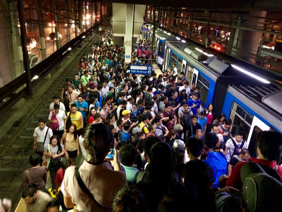 A very crowded Boni Avenue Station platform (photo courtesy of Mr. Raul Vibal)
Of course, the pronouncement from the MMDA launched quite a lot of memes on social media. Some people shared the typical quotes on planning (you know, like the ones about planning for people vs. planning for cars). Some offered their own ideas about how to “solve” traffic along EDSA. And so on…that only succeeded in showing how everyone had an opinion about transport and traffic. Everyone is an expert, so it seems.
Some thoughts and not in any order:
- The government can initially dedicate a lane each for express buses (a la Bus Rapid Transit or BRT). This idea has been circulating for quite some time now and has a good chance of succeeding. The DOTr is already deploying buses that they say are supplementing the MRT 3 trains (i.e., there aren’t enough trains running so passengers have the option of taking a bus instead). Running along the inner lanes of EDSA would mean, however, that they would have to find a way for passengers to cross the road and one idea would be for the stations to be retrofitted for this purpose.
- Those cars along EDSA are not necessarily for short trips so walking and cycling while needing space may have less impact in the immediate term for such a corridor. In the meantime, serious consideration should be made for bike lanes whether on the ground or elevated and improvements to walking spaces.
- But these efforts to improve passenger (and freight) flows should be a network-wide thing and not just along EDSA.
- It’s time to have serious discussions and perhaps simulations (even a dry run) of congestion pricing in Metro Manila. Congestion pricing for all major roads and not just one or two. Funds collected goes to mass transit, walkways and bikeways development. DOTr was supposed to have already discussed an Electronic Road Pricing (ERP) system like Singapore’s with the company and people behind the same in the city-state. That doesn’t seem to be moving along.
- Working and studying from home might work in terms of reducing vehicular traffic but then we generally have lousy internet services so that’s a barrier that needs to be broken down.
- How about legalizing, once and for all, motorcycle taxis? Many are opposed to this citing safety concerns but then we are running out of options outside the usual motherhood statements pertaining to building transport infrastructure. Think about it. Give it a chance. These motorcycles might just surprise us in a nice way; that is, helping alleviate congestion.
- Carpooling and lanes dedicated to High Occupancy Vehicles (HOV) would be good but the LTFRB made a pronouncement about these being illegal as they would be considered ‘colorum’. Such statements do not make the situation any easier and sends mixed signals as to the government’s being serious in considering all possible angles to improve transport and traffic particularly for commuting.
Do you have other ideas to share?
–
On the opposition to “complete streets”
I recently read an article about the opposition to road diets in California, USA:
Tinoco, M. (2018) “How to Kill a Bike Lane”, http://www.citylab.com, https://www.citylab.com/transportation/2018/05/how-to-kill-a-bike-lane/559934/?utm_source=SFTwitter [Last accessed: 5/20/2018]
So far, we know that at least three cities are progressive enough to implement road diets including Marikina City, Pasig City and Quezon City. Iloilo doesn’t count yet since their bike lane was constructed along the very wide Diversion Road. Our recommendations for Tacloban, if implemented by the city, will probably result in the second most comprehensive application of road diets/complete streets in the Philippines after Marikina, which implemented their bikeways network almost 2 decades ago. There are sure to be many who would be opposed to such schemes as many still have the view that streets are for motor vehicles. This car-oriented thinking is something that will be a challenge to advocates of people-oriented transportation systems. Hopefully, many can learn from experiences here and abroad on how to reclaim space for people leading to safer and more inclusive transport for all.
–
Proposed downtown traffic scheme for Tacloban City
The team from the National Center for Transportation Studies of the University of the Philippines presented their recommendations for the traffic scheme in downtown Tacloban City last May 4, 2018 in the city’s Traffic Summit cum City Development Council (CDC) meeting. I am sharing the image showing the proposed traffic circulation and other features for the proposed downtown scheme below:
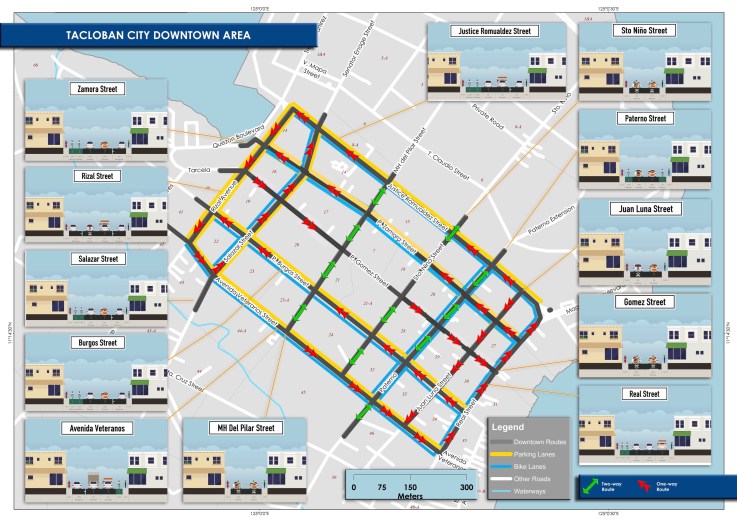
The scheme calls for a reduction in on-street parking; restricting such to one side of the street only and where applicable. That is, on-street parking is not allowed where there is already off-street parking along establishments, where there are driveways, and within one or two vehicle length from intersection corners. There will also be designated loading/unloading areas for public transport so parking is also prohibited there.
A couple of important features in the scheme are the enhancement of pedestrian facilities, particularly sidewalks, and the introduction of bicycle lanes. These are more clearly shown in the cross-section examples included in the map. Note that for other streets where there are no designated bike lanes indicated, it is assumed that lanes will be shared with motor vehicles. This is an application of the concept of shared right of way or “sharrow” as it is also termed. The scheme is contextualised along the lines of “people-oriented” transport rather than “car-oriented”, and hopefully would lead to a more walkable downtown area and encourage more people to use bicycles. This promotion of active transport should also lead to a healthier city. I will post about the transport plans prepared for the city in future articles here.
–
On Visita Iglesia and Quiapo transport and traffic
As it is already the Holy Week, I thought it would be good to write about transport and traffic around one of the busiest churches in the Philippines – Quiapo Church. This is surely a popular stop for the Visita Iglesia, which is a tradition for many during the Holy Week. People visit as many churches (usually the target is seven) as they can where they are supposed to pray the novena appropriate for the season.
 A side view of the church from Quezon Boulevard, which is the main access road for the church. Most public transport pass along this boulevard that connects to other major roads. It’s a good thing that the City of Manila has been stricter in enforcing against on-street parking here.
 In front of the church is Plaza Miranda, where many political rallies are held including one fateful rally in the early 1970s that eventually led to the declaration of martial law, is a bustling area with many vendors selling all kinds of items, religious and otherwise, including those that are claimed to be medicinal. Note though that vehicles are allowed to park on-street and this means people would have to hail jeepneys in the middle of the street.
 This is traffic along Quezon Boulevard as seen from the descent from the Quezon Bridge (Quiapo church is seen at the left). I took this around 4PM on a Wednesday so it was not surprising to have heavy traffic on both sides of the boulevard. I’ve been told, however, that for most of the day during weekdays, traffic is as heavy as this.
Traffic in Quiapo is not as heavy on Sundays (It’s also quite as bad on Saturdays.) and holidays. During the Visita Iglesia period of Holy Thursday and Good Friday, however, there will likely be heavy traffic in the area as a lot of people bring their own vehicles for the Visita Iglesia as well as for their “church tours”. I used the term “church tours” because I’ve observed that many don’t really come to pray (e.g., Stations of the Cross or novenas) but to take photos (i.e., selfies or ‘groupfies’) and eat & drink about. In Metro Manila, there are several churches popular for this tradition. These include Our Lady of Perpetual Help in Baclaran, Christ the King, Sto. Domingo and Our Lady of Lourdes in Quezon City, and the Manila Cathedral, San Sebastian, St. Jude, Malate and Binondo Churches in Manila. That is not an exhaustive list as there are many churches (old and new) spread around Metro Manila including those in other cities like Malabon, Marikina and Las Pinas. And then there are also the churches in the provinces surrounding Metro Manila, which I will try to write about soon…
–
 Caught (up) in traffic