
Home » Transport Planning (Page 14)
Category Archives: Transport Planning
Is there really a transport or traffic crisis in Metro Manila?
I was interviewed recently for a research project by students enrolled in a journalism class. I was asked by one in the group if we indeed have a transport crisis in Metro Manila. The other quickly added “hindi transport, traffic” (not transport but traffic). And so I replied that both terms are valid but refer to different aspects of the daily travel we call “commuting”. “Traffic” generally refers to the flow of vehicles (and people if we are to be inclusive) while “transport” refers to the modes of travel available to us.
“Commuting” is actually not limited to those taking public transportation. The term refers to all regular travel between two locations. The most common pairs are home – office and home – school. The person traveling may use one or a combination of transport modes for the commute. Walking counts including when it is the only mode used. So if your residence is a building just across from your office then your commute probably would be that short walk crossing the street. In the Philippines, however, like “coke” and “Xerox”, which are brands by the way, we have come to associate “commute” with those taking public transportation.
And so we go back to the question or questions- Do we have a transport and traffic crises? My response was we do have a crisis on both aspects of travel. All indicators state so and it is a wonder many including top government transport officials deny this. Consider the following realities for most commuters at present:
- Longer travel times – what used to be 30-60 minutes one-way commutes have become 60 – 120 (even 180) minute one-way commutes. Many if not most people now have double, even triple, their previous travel times.
- It is more difficult to get a public transport ride – people wait longer to get their rides whether they are in lines at terminals or along the roadside. The latter is worse as you need to compete with others like you wanting to get a ride ahead of others.
- People have to wake up and get out of their homes earlier – it used to be that you can wake up at 6:00AM and be able to get a ride or drive to the workplace or school at 7:00/7:30 AM and get there by 8:00 or 9:00AM. Nowadays, you see a lot of people on the road at 5:30AM (even 4:30AM based on what I’ve seen). That means they are waking up earlier than 6:00 AM and its probably worse for school children who either will be fetched by a service vehicle (e.g., school van or bus) or taken by their parents to their schools before going to the workplaces themselves.
- People get home later at night – just when you think the mornings are bad, afternoons, evening and nighttimes might even be worse. Again, it’s hard to get a ride and when you drive, traffic congestion might be at its worst especially since most people leave at about the same time after 5:00PM. Coding people and others not wanting to spend time on the road (instead working overtime – with or without additional pay) leave for their homes later and arrive even later.
- Less trips for public transport vehicles – traffic congestion leads to this. What used to be 6 roundtrips may now be 4. That affect the bottomline of income for road public transport providers. Given the increased demand and reduced rolling stocks of existing rail lines that includes rail transport.
To be continued…
—
Mixed messages for commuters?
I had spotted buses (or perhaps its just the same bus?) for a P2P service between Antipolo and Ortigas Center bearing what appears to be a statement for improving the quality of life of commuters. Many have been suffering and continue to suffer on their daily commutes starting from difficulties getting a ride to very long travel times. The term “dignity of travel” comes to mind, which a colleague coined many years ago to describe
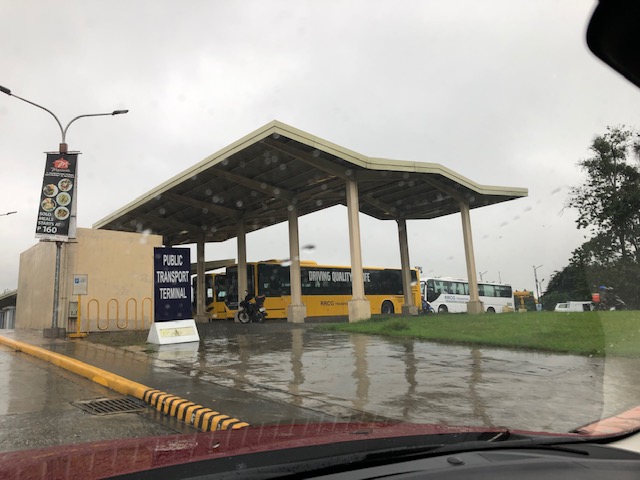 P2P buses at the public transport terminal at Robinsons Place Antipolo
 Whoever thought of this probably meant well; thinking about improving quality of life. The choice of words though may convey a different message as “driving” is in all caps and usually associated with a different, less appealing activity to sustainable transport advocates. I think they should have chosen “improving” instead of “driving” here.
This is somewhat similar to a much earlier post of mine showing SMRT buses in Singapore with ads promoting Uber and how it was supposed to complement public transport. That, of course, was a bit of a stretch in the city-state, which already has excellent public transport compared to elsewhere, and already complemented by very good taxi services.
Yesterday, there was a nationwide transport strike and depending on which side you are on, the reality is that we are still far from having more efficient public transport. But that’s another story and hopefully, I get to write about it in the next few days.
–
Quick share: “The ‘War on Cars’ is a Bad Joke
Here is another quick share. This time it is an article that I think attempts to diffuse what some many people regard as a war on cars being waged by those who advocate for public and active transport.
Litman, T. (2019) The ‘War on Cars’ is a Bad Joke, Planetizen, https://www.planetizen.com/blogs/105877-war-cars-bad-joke?fbclid=IwAR2_SZHQeYEUGiU2G8RUw0Za6GrkR-2peD3eSjshpNUOg9-G5SpDWm6OnFI [Last accessed: 8/25/2019]
The author makes very strong arguments supported by evidence and data to place this topic in the right context. That is, there is no need to “wage war” or use arguments that are more on the hateful side and therefore not constructive to both sides. I think there should be a mutual understanding of the benefits (and costs) of having many options for transport or commuting. That said, infrastructure or facilities should not heavily favour one mode (car-centric?) for transport to be sustainable and healthy.
Sadly, many so-called progressives (yes, I am referring to the younger generations who are still in the idealistic stage of their lives) appear to be blind to understanding but instead opt for the hardline stance vs. cars and those who use them. Instead of winning people over and convincing those who really don’t need to drive to take other modes, they end up with more people becoming more apathetic or unwilling to take a stand vs. the status quo. This is the very same status quo that is definitely degrading quality of life and is described as an assault to human dignity.
–
Quick share: “The changing role of transport strategy”
Here is a nice article briefly discussing the evolution of transport strategy planning that have led to local transport plans:
Gleave, J. (2019) The changing role of transport strategy, Transport Futures, https://transportfutures.co/the-changing-role-of-transport-strategy-598fce17e9e9 [Last accessed: 8/24/2019].
More importantly, there is a very good discussion here of the recent developments and the need to change approaches in order to become more effective at the local level. The article explains that there should be an appreciation of the availability of resources including tools that allow people to be more engaged or able to participate in the planning process for their cities, municipalities or communities.
–
A little bit of history – on how the US interstate highway system came to be
Here’s one of those quick shares that I usually post here. I am a bit of a history buff and mixing that with transport will likely lead to a post like this. Here is a short article about an event in the history of the US Army that happened 100 years ago:
editor@aashto.org (2019) Celebrating Highway History: The US Army’s 1919 Cross-Country Convoy, aashto.org, https://aashtojournal.org/2019/07/12/celebrating-highway-history-the-u-s-armys-1919-cross-country-convoy/ [Last accessed: July 12, 2019]
The article was particularly interesting for me because of two items: the road conditions and the man behind the US inter-state highway system. It took them a little over 2 months to cross the continental US because of poor road conditions. Many people have no sense of history and appreciation of what has been accomplished over the years and how difficult it was to travel at the time. I haven’t done the cross country trip but I have close friends who’ve done it and are thankful for the generally good roads they could use for the experiential road trip. Meanwhile, the person in the article – then Lt. Col. Dwight D. Eisenhower – is a man who made his mark in history at first as the Supreme Commander of the Allied forces in the European Theater in World War 2, who would later on become President of the US. I read elsewhere that the US interstate highway system was designed so aircraft may use them as runways in cases when the US were at war and the enemy had bombed their airports and airfields (just like what the Japanese did in the Pacific).
Do we have similar accounts for our roads and bridges in the Philippines? Were there key persons who may or may not be larger than life figures instrumental in developing our road infrastructure with their vision and leadership (Marcos doesn’t count because of his bogus military record and corrupt regime)? It would be nice to compile these and perhaps it should be a collaboration between the Department of Public Works and Highways (DPWH) and the National Historical Commission (NHC). They could even get the history departments of local universities involved for us to understand the evolution of transportation in this country.
–
Why more low capacity PUVs?
I’ve written about the recent additions of new (the government I think prefers to call them ‘modern’) model jitneys along corridors like Marcos Highway, C-5, Quezon Avenue, Espana Avenue, etc.). My main comment has always been about the capacities of these vehicles considering the high transport demand along these routes where the Department of Transportation (DOTr) and the Land Transportation Franchising and Regulatory Board (LTFRB) have authorised these so-called “experimental” routes. The services actually overlap with existing lines of other PUVs like jeepneys, UV Express and buses. Their value is apparently the single, direct ride they provide to commuters, who otherwise would have to transfer vehicles to get to their destinations. The popularity of these “experimental” services only underlines or emphasizes the need for rationalising transportation services especially in Metro Manila.
There are surely opportunities to improve the network including those taking advantage of the improvement of rail services. But rationalisation is not just about changing routes. It also means determining the right capacity vehicles for these routes. Thus, high demand corridors require higher capacity modes in terms of both vehicles and their frequencies. Perhaps authorities should look into the examples of P2P bus operations as a way of determining the type of vehicles to be deployed as part of the so-called experiment rather than appear to be just promoting these modern jitney models. PUV modernisation, after all, should also mean upgrading the existing vehicles servicing certain routes by replacing them with ones that are more efficient and with higher passenger capacities.
 This mini-bus lookalike has a capacity of 23 passengers. That’s practically the same as the newer model jeepneys that are generally longer and with some cleverness of the driver and conductor may seat more (i.e., Benches placed inside the jeepney increases their seating capacity. This set-up, however, is unsafe.)
–
Evidences of demand for Line 2 beyond Masinag (again)
My commute between my home and office usually takes me to Masinag where I make the choice between traveling via the typical Marcos Highway route or via the alternative Marikina/Tumana route. Here is a scene that I usually see whenever I pass by the informal UV Express terminal just past the Masinag junction along the westbound side of Marcos Highway and just before the Decathlon sports facility currently under construction.
 Passengers waiting for UV Express vans or AUVs to return around 8 AM. The latter serve the Cogeo – Makati (Greenbelt) route, which could take 2 or 3 rides using other modes of public transport (e.g., one ride to Cubao and another from Cubao to Makati)
Note how many people cannot get a ride around 8 AM. If only there were more efficient options then these people would likely take them but for now the obvious and practical choice for them is the UV Express. Others, of course, can just walk further to SM Masinag where there is a P2P bus service also heading to Makati. Recently, a new “experimental” route was opened between Cogeo and SM Aura in Taguig using modern jitneys.
Once completed, Line 2 should be able to provide an alternative for these commuters but there is still the issue of a seamless transfer in Cubao. There is no direct connection between the Line 2 and Line 3 stations with the former connected to the Gateway Mall while the latter is connected to Farmers. That is a significant walk between the two stations.
But where do the commuters in the photo come from (origin?)? Most likely don’t reside around Masinag Junction though there are many residential area around this location. Many are ferried here by tricycles, jeepneys or private vehicles. Many likely have their own cars but opt not to drive to/from Makati. That is actually a good thing and something that needs to be sustained rather than give a reason for these people to use cars for their commutes. And so there is a need to extend Line 2 perhaps to Cogeo, and a branch to Marikina. The Marikina branch, as I’ve mentioned before, could terminate at the Marikina Sports Center. Meanwhile the extension to Cogeo should not stop there but continue further towards Antipolo’s new government centre. This corridor’s population is steadily increasing and the transport demand must be addressed not by low capacity modes but by a mass transit system. The low to medium capacity modes should be in support or at most supplementary to the high capacity system with the Line 2 as backbone.
–
On unlocking the potential of shared transportation
Here’s a quick share of a very nice article that’s very informative and therefore useful to people seeking to tap into the potential of shared transportation to help alleviate transport woes in their cities and towns:
Miller (2019) “9 Ways Cities Can Unlock the Potential of Shared Transportation”, Medium.com, https://medium.com/frontier-group/9-ways-cities-can-unlock-the-potential-of-shared-transportation-66a53b2c841 [Last accessed: May 3, 2019]
So far, we only have few examples of shared transportation in the Philippines. These include a few bike shares in Metro Manila and does not count ride-hailing/ridesharing, which we now know is not really a sustainable form of transport.
–
Public transport coverage in Metro Manila
I saw several posts circulating on social media about public transport routes in major cities that included stylised maps presented like the transit maps you usually see for cities like Tokyo, Hong Kong and Singapore. These show what the makers identify as the equivalent of stops or stations along the public transport “lines”. These, of course, are a simplification because what appears as a single line may actually be comprised of several. Also, the overlaps seem to be also quite simplified compared to what may be found in reality. This post will not attempt to show how complicated road public transport is for Metro Manila. Instead, I am sharing the maps prepared from a previous study we conducted for the then DOTC (ca. 2012) that show the coverage of three road public transport modes: buses, jeepneys and UV Express.
 PUB coverage for Mega Manila with distinction of EDSA and non-EDSA routes (2012)
 Jeepney route coverage for Mega Manila (2012)
 UV Express route coverage for Mega Manila (2012)
I hope these maps have already been updated or are going to be updated in order for us to have good visual references for public transport planning including the identification of locations for integrated terminals as well as connections with rail transit.
–
Article on sustainable transport’s role in “saving the world”
Here is another quick post on another article I am sharing showing the importance of sustainable transport:
Milner, D. (2019) How sustainable transport can save the world, medium.com, https://medium.com/@djjmilner/how-sustainable-transport-can-save-the-world-f2f64517dc52 [Last accessed: 4/9/2019]
It goes without saying that sustainable transport has a lot of potential for helping mitigate climate change and other issues but much is expected of our leaders for policies and program & project development & implementation towards achieving sustainable transport in our cities and municipalities.
–
