
Home » Transport Planning (Page 23)
Category Archives: Transport Planning
Another look at Iloilo’s main bikeway
Much has been written and said about Iloilo’s bikeways and particularly about the grander one built along the main highway that is Ninoy Aquino Avenue. This bikeway is already usable but is being extended along with the road widening works for the national road that connects major towns in central Iloilo province including Sta. Barbara and Cabatuan, which host the international airport. Here are some photos and commentaries on the bikeway.
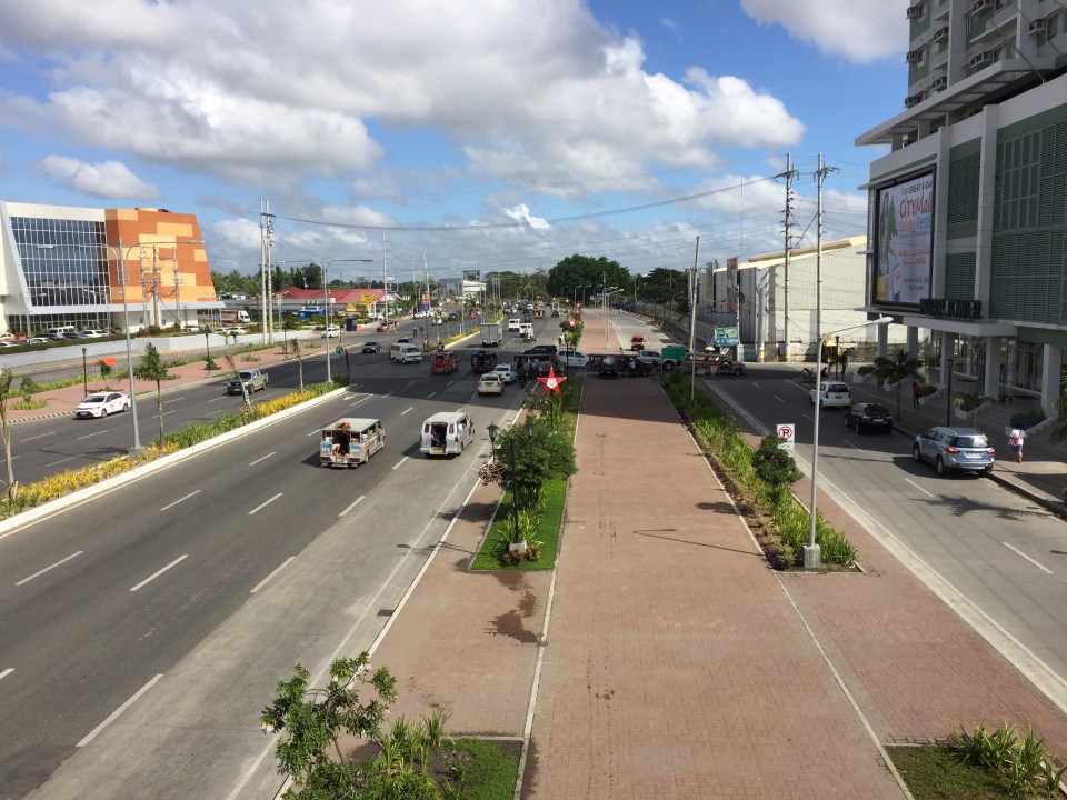
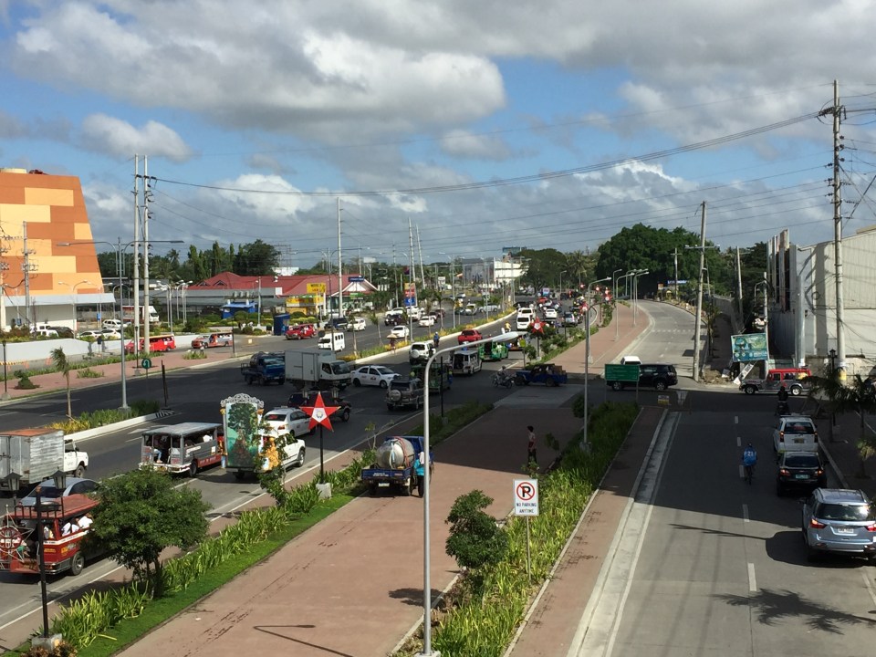 Iloilo City’s wide bikeway along Ninoy Aquino Ave (formerly the Iloilo Diversion Road) – the building on the left is SM City’s recently opened expansion. The photos were taken from the pedestrian overpass across the diversion road.
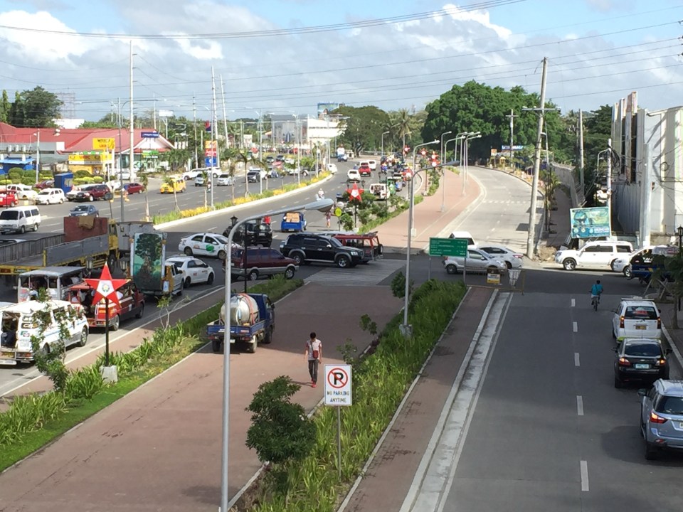 A closer look of the traffic conflicts at the intersection with Jalandoni Street – the 3-leg intersection is not as simple as it initially looks because of traffic coming from/going to the service road on the right. It is quite obvious in the photo that the alignment of the service road changes abruptly, affecting the trajectory of flow along the road.
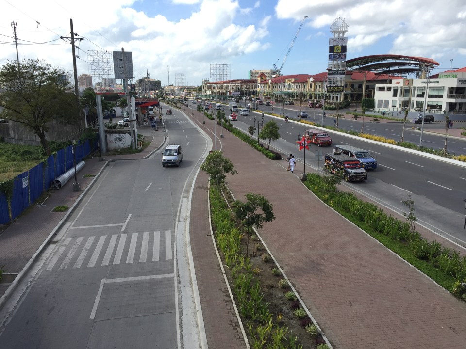 The photos were taken around 9:30 AM and there was practically no bicycle traffic to be seen. To be fair, perhaps there is significant bicycle traffic, particularly the commuting kind, earlier in the morning and later in the afternoon. Bicycle volumes need to be measured and monitored to determine if the bikeways indeed have encouraged more people to take up cycling as a mode for their regular commutes. That’s the Plazuela in the background on the right.
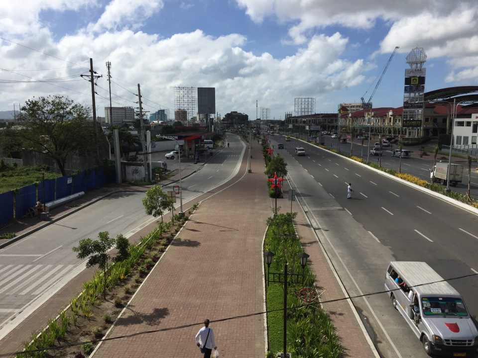 Another look at the bikeway shows it emanating from Iloilo City proper where it ultimately connects to the bikeways at the Promenade along Iloilo River. There are no bikeways within Iloilo’s CBD itself.
 The photo above shows the bikeway and beyond (towards Jaro and Pavia) with the new SM annex at left and the Injap Tower Hotel on the right.
–
Differences: pro-walking vs. anti-car
I came across this article posted at the Planetizen site entitled Pro-Walking, or Anti-Car. It is a good article that heads-on addresses the the differences of being pro-walking to that of being anti-car in terms of transport policies in cities. I think these concepts including the “nuts to crack” list provided by the author is relevant not only to cities that want to promote walking and cycling over car use, but to individuals and groups as well who seem to be following a hard line when in comes to their advocacy to recover road space in favor of pedestrians and cyclists.
Encouraging and providing incentives for walking
A friend based in Singapore posted a photo showing a poster promoting a ‘National Steps Challenge’. The objective apparently and obviously is for Singaporeans and foreign nationals living there to get into walking. The target, according to the poster, is 10,000 steps per day. There are even illustrations in the poster showing estimates of how many steps you can do at the home, the office or during your regular commute.
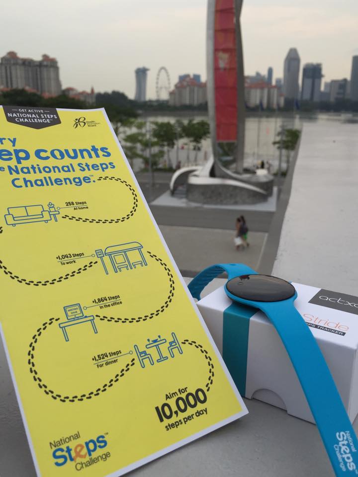 [Photo courtesy of Engr. Joy Garcia]
Such programs are exemplary and are aimed at boosting citizen’s health and welfare. Of course, Singapore can do this and many will respond even without rewards because Singapore has excellent transport infrastructure including an extensive public transport system and suitably designed pedestrian facilities.
Can cities in the Philippines come up with a similar challenge? Are there cities with good enough pedestrian facilities that can lead the way and become good practice examples in promoting walking; not just for the reason of commuting but also as a means to achieve better health among its citizens? Authorities can even include infographics on promotions showing the number of calories you can burn for typical walking trips as well as the health benefits one can derive from walking regularly. I think there are many cities that have decent infrastructure and attractive routes to promote walking. Among them are Vigan City, Marikina City, Legazpi City, Iloilo City and Davao City. Hopefully, these cities can take the cue from Singapore in promoting walking and perhaps, too, a national agency like the Department of Health can pitch in to promote this worthwhile cause for healthier lifestyles.
–
Unprepared and incomplete – realizations from the APEC transport experience
Before I forget about what transpired during the holding of APEC in Manila a week ago, here’s a couple of photos I found over the internet and shared via social media.
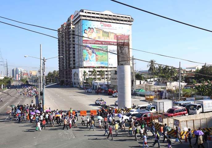 Commuters along Roxas Boulevard walk past a column of the unfinished NAIA Expressway, one of the transport infrastructure projects that has not been finished. [Photo from The Manila Bulletin]
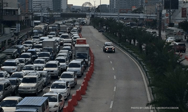 APEC lanes and severe traffic congestion along EDSA – there’s an opportunity here for a prrof of concept test for BRT. [Photo from Facebook]
I saw many memes and read some articles mentioning BRT specifically as one solution to Metro Manila’s transport problems. The second photo above was modified to replace the car travelling along the APEC lanes with a bus.
It is easy to imagine what could have been if the government decided to use the event and the lanes they allocated for APEC vehicles to do a ‘proof of concept’ run of BRT services or at least express bus services (what some DOTC people call high quality bus services). Perhaps what could have been done for part of the 10 billion PHP expended for APEC was to buy a fleet of brand new buses and provided these for free public transport for people who would need to commute during APEC. Services along two corridors would have sufficed – these two would have been EDSA and Roxas Boulevard. [The other option would have been to talk to bus operators and cooperate with them to organize express bus services along EDSA and Roxas Blvd.] Aggressively promoting these free services ahead of APEC would also have meant commuters, including those who usually used their own vehicles, could have opted for these transport services and not affected by the ‘carmageddon’ that ensued over that period. There should have been services to the airport terminals, too, but I will write about this in another article.
The dry run could have yielded essential data for assessing the feasibility of such bus services as an alternate to rail systems that would take much time to build. Incidentally, if the LRT Line 1 Extension to Cavite was built right after the current administration took over, that line could have already served tens of thousands of passengers from the south who regularly commuted to Metro Manila for work and school. The first photo above does not lie about just how many people could have benefited from that rail project. Meanwhile, MRT Line 3 remains dysfunctional and with its reduced capacity could not handle the demand for transport that it should have been able to carry if services had not deteriorated over the years.
–
Looking back at EST social marketing
With all that are happening today that are related to sustainable transport, I tend to pause and look back with a smile on how it was more many years ago when we were struggling to promote environmentally sustainable transport (EST). At that time, most local government units were not yet into sustainable transport and were unaware of the principles. There were a few who already had a project or program in place but didn’t know that these were classified as EST.
CAPACITY-BUILDING AND SOCIAL MARKETING FOR ENVIRONMENTALLY SUSTAINABLE TRANSPORT
Under the project, we identified several local good practice examples for EST and invited representatives of those LGUs to spread the word to other LGUs. Those who regularly went with us to promote EST were representatives of the Marikina City Bikeways Office, and San Fernando, La Union’s City Planning Office who shared their experiences in phasing out 2-stroke motorcycle-run tricycles.
I recall that one major Visayan city wasn’t so receptive at the time as the City Planning Coordinator seemed more interested in international trainings and foreign assisted projects than the city actually developing sustainable programs and projects on its own. The irony now is that despite his being not so excited about sustainable transport that city now has good examples for EST including a bicycle corridor and pedestrian and bike-friendly riverside developments.
But there was the case of the very receptive and progressive City Planning Coordinator of another major Visayan city who helped us immensely in promoting EST. His eagerness, particularly for public transport options, paved the way for Bus Rapid Transit (BRT) to gain a foothold in the discussions paving the way for more efficient transit systems to be considered (and now planned and designed) for his city. That interest led to his city getting the attention of an international agency that brought in then former mayor and now the recently re-elected Mayor of Bogota, Colombia, Enrique Penalosa, to do talks about his city’s Trans Milenio BRT system. I remember a couple of visits of Mr. Penalosa including a series of dinner meetings sponsored by the private sector in Makati City who were interested in the Bogota’s transport success story.
We always wondered who, when and how EST would be advocated by others and particularly by a younger generation who would turn out to be more outspoken and aggressive in promoting EST. These include those calling for better public transport systems, those advocating for pedestrian and bicycle facilities, those pushing for safer roads, and those lobbying for clean air. With all that we are seeing now around us (Congratulations Firefly Brigade for a very successful Tour of the Fireflies last Sunday!) and on various media platforms, I strongly believe that we are on the right path towards achieving better quality, sustainable and equitable transport for everyone.
–
Some advantages of rail over road transport
In my previous article, I mentioned how rail transport is important as part of a country’s transport system, particularly on land. I also mentioned a study conducted by our undergraduate students that was completed back in April 2012.
Our students conducted a simple survey, as part of their research, to determine the travel times and costs for public transportation between several origin-destination pairs. These O-D pairs were selected to simulate costs and travel times of commutes using either primarily rail or all road transport. Note the choices of either ‘school’ or ‘office’ paired with ‘home’ somewhere in the south of Metro Manila.
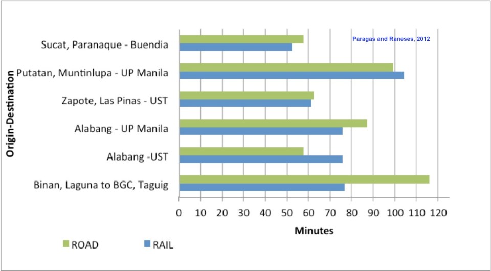 Travel time comparisons for commutes using road and rail public transportation – ‘Road’ refers to the entire commute using road-based transport (i.e., buses and jeepneys) while ‘Rail’ refers to commutes utilizing mainly the PNR but with road transport used in the end parts of the journeys (e.g., jeepney ride from near the PNR Espana Station to UST).
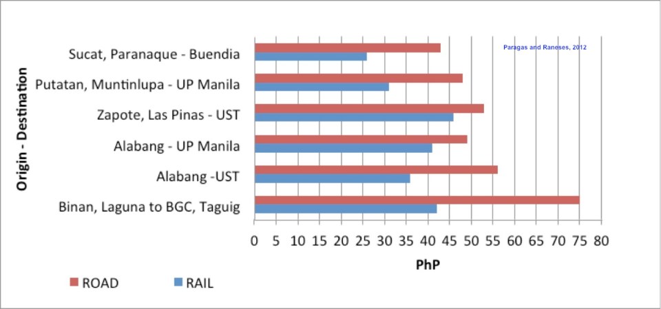 Travel cost comparisons for commutes using road and rail public transportation
Relevant to understanding the above are the following
- Fare rates have changed since 2012. However, this presents a constant change over the fares that are being compared so the basic differences will remain the same across origin-destination pairs.
- PNR services had to be discontinued for some time due to derailments because of poor conditions of tracks.
- Road traffic has worsened since 2012 with several “carmaggedon” episodes showing how vulnerable commuters are when using solely road transport.
- Road public transport services are frequent and practically 24/7. PNR services are of very limited frequency. Waiting times for the trains typically add to travel times in the form of delays, which make commuting by rail an unattractive option due to their unreliability of service.
–
On the severity of traffic congestion along Ortigas Avenue and the necessity of a mass transit line
With the worsening congestion along Marcos Highway due to the construction of the LRT Line 2 Extension to Masinag, I have been using Ortigas Avenue as an alternate route to go home. Granted, the stretch from the Park Place gate near Cainta Junction and Brookside is currently undergoing roadworks elevating that entire section (which is prone to flooding), and this is the main cause of much congestion as fewer lanes are usable to traffic. However, what is perceived to be relief from traffic once the project is completed will eventually and surely revert to a very congested Ortigas Avenue.
Traffic congestion along Ortigas Extension is primarily due to a dependence on road transport, particularly private vehicles, by people living along Ortigas Ave. and the roads feeding into it. The Manila East Road, for example, passes through the most populous towns of Rizal outside of Antipolo City. The dependence on road transport (especially private vehicles) is due to limited options for public transport. There are buses, jeepneys and UV Express but these, too, contribute to congestion due to their increased numbers and limited capacities given the high demand for public transport. Among the infrastructure proposed along this corridor is an overpass along Ortigas Ave. at Cainta Junction. A mass transit system has also been required along this corridor for a very long time but for some reason, such infrastructure has not been provided.
 Severe traffic congestion along both directions of Ortigas Avenue Extension
 Congestion stretches all the way along the Manila East Road
 Night-time traffic congestion at the Tikling Junction
There is a proposal for a mass transit system along this corridor. Following are references to the project:
From the PPP Centre: https://ppp.gov.ph/?ppp_projects=ortigas-taytay-lrt-line-4-project
From CNN Philippines: http://cnnphilippines.com/metro/2015/07/22/neda-approves-naia-lrt-ppp-projects.html
I found it quite odd that the stations are not referenced according to the more common place names for the locations. For example, ‘Bonifacio Avenue’ should be ‘Cainta Junction’ and ‘Leonard Wood’ should be ‘Kaytikling Junction’. Nevertheless, this is the least of our concerns pertaining to transport and traffic along this corridor.
Perhaps the conditions are ripe now to finally implement transport infrastructure projects along this corridor. The proposal and approval of a rail transit line by NEDA means the corridor has the national government’s attention. The local government leaders along this corridor are also more progressive and aggressive than their predecessors. These include a very dynamic mayor in Cainta and the former governor-turned mayor in Antipolo. A collaboration towards better transport among these two LGUs alone would be influential and instrumental to improving travel along Ortigas Avenue.
–
Proposals for EDSA and some alternate roads
The hellish traffic congestion along EDSA and other roads in Metro Manila spawned a bunch of ideas for alleviating congestion. Among those that were offered as solutions are the following:
- Odd-Even Scheme – suggested by the Philippines President himself in a speech delivered in Mandaluyong City
- Car-pooling (and HOV lanes) – suggested by the DPWH Secretary in another forum
- Bus Rapid Transit (BRT) and/or express bus – proposed and being studied by the DOTC
What seems to have been forgotten was a proposal to have two lanes of EDSA, one on either direction, devoted to bicycles. This proposal now seems to be the most viable compared to the above three and could have the potential for major behaviour change towards a departure from motor vehicle use. Cycling along with walking does not require fuel and these modes also promote healthy lifestyles. Also, this could become the ultimate example for road diets, which can also be applied along other roads as well. What sounds or reads like an outrageous idea (i.e., bicycle lanes along EDSA) might just be revolutionary and result in what could be a tipping point for sustainable transport in the midst of traffic mayhem.
EDSA has become the proverbial battleground representing the war with traffic congestion. However, EDSA is just one part of our arterial network comprised of circumferential and radial roads. There is also C-5 (also known for its sections – Katipunan, E. Rodriguez, C.P. Garcia), which is also a very congested road but along which there are few fixed route public transport services. It is a primary alternative route (to EDSA)for people traveling between the northern and southern halves of Metro Manila. It also serves as a collector and distributor, being connected with major radial roads like Aurora Boulevard, Ortigas Avenue and Shaw Boulevard as well as to the South Luzon Expressway. C-5 is a major truck route, however, and so carries a lot of heavy vehicles during the permitted times under the truck ban scheme being implemented in Metro Manila. C-5 is already ripe for a mass transit system and should have one along it. The quickest to put up would be a bus system on exclusive lanes. Strategically though, a rail transit line (likely elevated) should already be planned and implemented and with as seamless as possible connections to current and future lines along major corridors.
There are other routes that can be considered which I think have been overlooked (too much focus on EDSA?). C-6, for example, badly needs to be improved and this has started but is being implemented at a slow pace. This could have significant positive impacts on traffic coming from the east (towns of Rizal province) that are bound primarily for Makati and BGC. But then there also has to be a good road bypassing the narrow and already congested streets of Taguig and Pateros that are currently the only roads connecting C-5 and C-6. The roads on the Rizal side (attention: Cainta and Taytay) also need to be improved including Highway 2000 and the Barkadahan Bridge. Perhaps the Rizal Provincial Government should also get involved in this as such routes are in the best interest of Rizalenos. And then there is also the highly urbanized city of Antipolo that is a major destination and already is the 7th most populous city in the country, whose residents also use this route, which is often a faster option to Ortigas and C-5 despite the poor conditions of roads.
–
Local papers presented at the EASTS 2015 conference – De La Salle University
De La Salle University (DLSU) has a strong program in transportation engineering and planning. This program is under its Department of Civil Engineering and led by Dr Alexis Fillone. Following is a list of papers from DLSU:
- Mode Shift Behavior of Bus Passengers to Rail System under Improved Rail Conditions [Alexis Fillone & Germaine Ann Dilay]
- Evaluating Proposed Transportation infrastructure Projects in Metro Manila using the Transport Co-Benefit Analysis [Alexis Fillone]
- Inter-Island Travel Mode Choice Analysis: Western Visayas Region, Philippines [Nicanor Roxas Jr & Alexis Fillone]
- Revisiting Volume-Delay-Functions Used in Transport Studies in Metro Manila [Jiaan Regis Gesalem & Alexis Fillone]
- Characterizing Bus Passenger Demand along Epifanio de los Santos Avenue (EDSA), Metro Manila [Sean Johnlee Ting, Kervin Joshua Lucas & Alexis Fillone]
- Optimized Bus Schedules in Epifanio Delos Santos Avenue (EDSA), Metro Manila Using Fuzzy Rule-Based System [Alexis Fillone, Elmer Dadios & Ramon Intal]
- Opinion Survey about Pedestrianization of Heritage Sites in the City of Iloilo, Philippines [Alexis Fillone & Frederick Sosuan]
- Factors Influencing Footbridge Usage Along Epifanio Delos Santos Avenue (EDSA), Metro Manila [Aaron King, Rigel Cadag, Jireh Despabiladeras, Rei Tumambing & Alexis Fillone]
- A Compact Scheduling and Revenue Estimation Spreadsheet for Bus Operators [Raymund Abad & Alexis Fillone]
- Adaptive Driving Route of Busses along Epifanio de los Santos Avenue (EDSA), Metro Manila, using Fuzzy Logic [Alexis Fillone, Bernard Yasay & Elmer Dadios]
I thought DLSU could have published more papers in this conference. I was actually surprised that all the papers are practically attributed to Dr Fillone considering his co-authors are mostly his students. But then there are only 2 to 3 faculty members who are doing transport research in DLSU and Dr Fillone is the most involved and prolific among them in terms of published research outputs.
–
Local papers presented at the EASTS 2015 conference – University of the Philippines
There were a lot of technical papers from Philippine universities that were presented in the recently concluded 11th International Conference of the Eastern Asia Society for Transportation Studies (EASTS 2015). In the interest of dissemination, I will be featuring a list of papers produced by leading universities in the Philippines that are doing studies on transportation. Following is a list of papers from University of the Philippines Diliman that were presented at the EASTS 2015 held in Cebu City last Sept. 11-13, 2015:
- Innovative Collection of Road and Traffic Data for Road Safety Audit (Aileen Mappala & Ricardo Sigua)
- Study on Safety of Railway/Highway Grade Crossings in the Philippines (Albie Clarito, Beverly May Ramos & Ricardo Sigua)
- Instantaneous Fuel Consumption Models of Light Duty Vehicles and a Case Study on the Fuel Consumption at Different Traffic Conditions in Metro Manila using Shepard’s Interpolation Method (Ernesto Abaya, Karl Vergel, Ricardo Sigua, Edwin Quiros & Jose Bienvenido Biona)
- Development of Drive Cycles and Measurement of Fuel Economies of Light Duty Vehicles in Metro Manila (Ernesto Abaya, Karl Vergel, Ricardo Sigua & Edwin Quiros)
- Selection of Metro Manila BRT Corridors Using Multi- Criteria Assessment (Ricardo Sigua & Cresencio Montalbo, Jr.)
- An Assessment of Walkability in a Medium-Sized Philippine City (Hilario Sean Palmiano, Sheila Flor Javier & Jose Regin Regidor)
- Traffic Noise Measurement, Perception, and Modelling in a University Campus (Hilario Sean Palmiano, John Carlo Villar & Michelle Monelle Quilatan)
- Assessment of Metro Manila Bus Fare Computation (Sylvia Chavez & Hilario Sean Palmiano)
- Estimating Road Roughness Conditions Using Ubiquitous Smartphones and Geographic Information Systems and its Application to Road Network Planning in the Philippines (Joel Cruz & Jun Castro)
- Fuel Economy and Public Utility Jeepneys Using 2% and 5% Coco-Metyl Ester (CME)-Diesel Blends (Edwin Quiros & Karl Vergel)
- Comparison of Fuel Economy of Fuel and Operating Characteristics of Diesel and Auto-LPG Jeepneys through On-Road and Vehicle Tests (Edwin Quiros, Karl Vergel, Ernesto Abaya, Ervin Santos & Jose Gabriel Mercado)
- Challenges of Urban Transport Development in Metro Manila: A look back at the last 40 years (Maria Sheilah Napalang & Jose Regin Regidor)
- An Assessment of the Public Necessity Concept for Estimating the Requirements for Public Transport Vehicle (Arnel Manresa, Karl Vergel & Jose Regin Regidor)
- State of Pavement Engineering in the Philippines and Implications on the Economic Life of National Roads (Maria Sheilah Napalang, Jose Regin Regidor & Nathaniel Diola)
- Planning Metro Manila’s Mass Transit System (Ricardo Jose, Daniel Mabazza, Jose Regin Regidor, Marco Stefan Lagman & Jonathan Villasper)
- Evaluation of Compliance of Dimensions and Selected Systems and Components of Customized Local Road Vehicles (CLRV) with Vehicle Regulations and Standards (Karl Vergel, Rachel Habana, Nonilo Peña, Loreto Carasi, Albert Mariño & Alorna Abao)
- An O-D Approach of Estimating Energy Demand and CO2 Emission for the Luzon Road Transport using Inter- Regional Passenger and Freight Flow Data (Marloe Sundo & Karl Vergel)
- Dignity of Travel: BRT Development in the Philippines (Cresencio Montalbo Jr & Colin Brader)
- Mending a Metropolis – Understanding Passenger Demand Across Metro Manila To Improve Road Transit (Nicholas Greaves & Cresencio Montalbo Jr)
- Accident Hotspot Mapping in Quezon City: The case of Katipunan Avenue (Jerome Ballarta, Nelson Doroy, Ishtar Padao & Cecil Villanueva)
Not included in the list are papers coming out of International Research Groups (IRG) as well as those where involvement by UP faculty were incidental to projects. Many of these papers will soon be posted on the official site of the International Scientific Committee of EASTS as part of either Proceedings or Journal of EASTS. Some may be nominated for the Asian Transport Journal (ATS), which is also published by EASTS.
Transportation research in UP Diliman is the most developed among schools doing research on these topics in the country. Papers came from a variety of disciplines and academic units including Civil Engineering, Mechanical Engineering, Urban Planning, Geography and History. These mostly were and are undertaken through the National Center for Transportation Studies (NCTS), which is with UP Diliman.
Next up: De La Salle University
–
