
Home » Transport Planning (Page 26)
Category Archives: Transport Planning
A tale of two consultants
I attended a seminar last November where there were two foreign consultants who gave talks about public transport and the reforms required for Metro Manila. One consultant had extensive experience in public transport, having worked in Hong Kong and Singapore, and is currently a consultant in Jakarta. The other appeared to have the more limited experience but claimed credit (I think partial at best) for public transport reforms in a major Asian city. I was impressed by the first in part because he was very honest with his statements especially as he explained a list of prerequisites for fixing public transport in Metro Manila (and other large cities). The bottomline from his presentation was that it was not possible to have a quick fix and there are no easy paths towards solving public transport problems in Metro Manila and elsewhere in the Philippines.
The second consultant was more on the patronizing side – promising a lot and a little too optimistic to be realistic or practical in his presentation on how to solve Metro Manila’s public transport woes. His material was hodge-podge at best with lots of visuals but not really getting to the point in terms of concrete solutions. It only betrayed his very limited if not unfamiliarity with transport and traffic in the metropolis despite his being a consultant with the office of the highest official of the transport department. There is a saying that if something seems to good to be true, it probably is. I think the same applies to what the second consultant presented to us that morning.
We need more of the first type of consultants who will tell us how it really is with regards to the “challenges” we face in solving transport and traffic problems in this country. The second type just lets us into a false sense of confidence or a feeling that the problems are not so big or complicated and that we are not in a big, deep hole that we need to climb out of. Its one thing to throw caution to the wind and another to have oneself firmly grounded in terms of the understanding of the problem at hand. Understanding the problem is the first step in the formulation of suitable alternatives and allows for the elimination or at least the minimisation of non-practical and non-realistic options.
–
Transport wish list for 2015
Last year, I opened with a very hopeful post on opportunities with certain mass transit projects that were hyped to be starting construction in 2014. The year 2014 went by and practically nothing really concrete happened (Yes, there were soil tests conducted for the LRT 2 extension but after that nothing else happened with the project.) with respect to these very critical mass transit projects that were already much delayed. It’s the same thing again this year so that same blog post from Jan. 1, 2014 applies this year.
I will not write down a list of New Year’s resolutions for the transport-related government agencies to adopt this 2015 though that stuff is quite tempting to do. Instead, I will just rattle of a wish list that includes very general and very specific programs and projects I would like to see realized or implemented (e.g., start construction) within the year; preferably from the first quarter and not the last. For brevity, I came up only with a list of 10 items. It is not necessarily a Top Ten list as it was difficult for me to rank these projects.
1. LRT Line 2 Extension from Santolan to Masinag
2. LRT Line 1 Extension to Cavite
3. MRT Line 7 from Quezon City to San Jose del Monte, Bulacan
4. Cebu BRT
5. People-friendly road designs
6. Integrated fare collection system for Metro Manila trains
7. Bikeways in major cities
8. Any mass transit project for Davao City or any other major city outside of Metro Manila or Cebu
9. Northrail or whatever it is that will connect Metro Manila with Clark
10. Protection of heritage homes and sites along highways and streets
The reader is free to agree or disagree with the list or to add to the list. I’m sure there are a lot of other projects out there that are also quite urgent that are not on my list but are likely to be equally important.
–
The engineering blame game and a need for some re-education
A prominent architect was always posting on his social media account about how much of what’s wrong with our infrastructure (especially transport-related) are due to engineers. It was a sad commentary particularly because he wasn’t mentioning anything about the involvement and responsibility of architects in the planning and design of infrastructure. For most projects that fall under the category of ‘planned development’ including mixed use developments like the Eastwoods, BGCs, Nuvalis, MOAs, and other similar projects are planned and designed mainly by a team of architects. Highways and streets are part of these projects and often, engineers are given the task of detailing and in certain cases, analyzing and ending up with the responsibility to justify designs provided to them. So for those types of projects funded or led by the private sector, its probably the architects who have much say in the plans and designs and who should be scrutinized for their shortcomings in as far as sustainable or “green” criteria are involved.
It is a whole different story, however, for public roads, especially those that are classified as national roads. The reality is that many DPWH engineers need to re-tool, learn and practice principles of sustainable infrastructure design. This includes incorporating green or environment-friendly design principles, which includes consideration of the landscape. We met some DPWH engineers in one seminar before on sustainable transport who thought environmentally sustainable transport (EST) was simply environmental impact assessment (EIA) and who proudly claimed they already knew about the topic. I think many engineers and planners in government need to unlearn many things and dissociate their minds from a lot of what they have come to accept as standard, acceptable or correct that are actually sub-par, archaic or flawed. Kapag nakasanayan na at matagal nang ginagawa o ginagamit ay napagkakamalang tama at angkop kahit na sa katotohanan ay hindi.
A good appreciation of history and heritage also appear to be scarce these days whenever the DPWH is involved. Proof of this are the road widening projects in Leyte and Iloilo that now threaten many ancestral houses that are located along the national roads. Many contend that road widening is unnecessary because congestion has not set in along many of the sections that have been widened or are candidates for such projects. It can be seen along many widened roads along Tarlac and Pangasinan, for example, that the problem is not really congestion but poor enforcement of transport and traffic regulations. Such include tricycle operations, roadside parking, and encroachments on the road right of way (RROW).
In most cases its pure and simple analysis that needs to be conducted first. Are roads really congested and requiring additional lanes? The evidence does not seem to support many cases of road widening as data on congestion from the DPWH Atlas itself requires validation on the ground. A recent World Bank study, for example, found that for many national road sections reported as congested in the Atlas, the opposite is true when validated on the ground. Such issues with data that are used as basis for decisions whether sections need to be widened are serious and lead to a waste of funds as well as negative impacts on heritage or historical structures.
The DPWH still needs to do some re-inventing and should actually take the lead in many initiatives. Among these are those pertaining to what are being referred to as “complete streets.” Last week, there was an article in newspapers where the DENR called for pedestrian and bike lanes along roads. The call was not specific to national or local roads but it is something that the DPWH should have already anticipated and working at for roads under it jurisdiction given the outcomes of the International Road Assessment Program (iRAP) project that covered several thousand kilometers of national roads that pointed to the need to improve roads to improve safety for pedestrians and cyclists. It is a matter of having progressive or dynamic rather than reactive or static stance at the DPWH and this requires more than just the rudimentary engineering background for the agency to take road planning, design and construction to another level.
–
What’s wrong with Marcos Highway?
Traffic along the eastbound direction of Marcos Highway in the late afternoons to evenings have worsened particularly for the section stretching from Aurora Boulevard in Quezon City to Imelda Avenue in Cainta. It takes me at least 45 minutes just to traverse that section and then just under 30 minutes the rest of the way to my home in Antipolo. In addition, there is the traffic along Katipunan, which can be quite unpredictable despite the traffic signals now installed at two major intersections near Ateneo and Miriam. The congestion along Marcos Highway is usually due to several factors:
- Rush hour(s) traffic – the sheer number of vehicles during the afternoon/evening peak is enough to cause traffic congestion along Marcos Highway. This is no longer for an hour but for a period usually spanning about 4 hours (5 to 9 PM). It’s become so bad that I am no longer surprised when I go home late some nights to find out it’s still congested at certain points (usually Santolan and Ligaya) past 9 PM.
- People occupying the road – commuters waiting for a ride along Santolan, Ligaya and Metro East/Sta.Lucia often occupy not just one but 2 to 3 lanes of Marcos Highway. This drastically reduces road capacity. For some reason, the MMDA and LGU traffic enforcers could not persuade them to clear the carriageway or at least encroach only on the outermost lane.
- Errant road public transport – loading and unloading operations of jeepneys and UV express happen in the middle of the road. This is partly due to the fact that people already occupy 1 to 3 of the outermost lanes of the road. It is also partly due to driver behaviour as many PUV drivers are unruly. These are also maybe because the enforcers are not doing their jobs managing traffic and apprehending those violating rules and regulations whether driver or pedestrian.
- Major trip generators – there are already 4 malls along Marcos Highway (SM Marikina, Robinsons Metro East, Sta. Lucia East Grand Mall, and SM Masinag) and a 5th is already under way with Ayala constructing a mall at Ligaya. These will attract and produce significant traffic with vehicles generally contributing to congestion in the direct vicinity of the malls but spreading along all major roads. Unfortunately, Marcos Highway is one if not the only access road that these malls have.
A lot of people using their own vehicles live in areas served by Marcos Highway including those beyond Masinag and Cogeo. There are so many subdivisions and other residential areas in these parts east of Metro Manila that vehicles from these residential areas alone can cause sever congestion at Masinag Junction. But this should not come as a surprise given that there is no efficient mass transport system in these areas, which are served primarily by jeepneys and tricycles. Obviously, the quality of service of existing road public transport encourages people to get their own vehicle. And obviously, too, the solution is in a project that is considered “bitin” – LRT Line 2, which currently terminates at Santolan. The extension project has long been delayed and could have a significant impact on transport and traffic once it is constructed and becomes operational.
The past two weeks, I have proceeded to take C-5 and turned to Ortigas Avenue Extension on my way home. Surprisingly, traffic has not been bad at Cainta junction and I have only occasionally encountered congestion at the section in front of the BF Metals plant where jeepneys turning around tend to block traffic during their maneuvers. I estimate that I average just under an hour on this route, a savings of 30+ minutes from my original home-bound route via Marcos Highway and Sumulong Highway. I figure that I will most likely keep using this route as traffic will continue to worsen along Marcos Highway in the run-up to Christmas.
–
The numbers that matter – some thoughts on data
Too often we are bombarded with statistics, numbers that are supposed to describe the state of things. This is especially true in transportation and traffic where there seems to be a lot of information or data circulating about all kinds of stuff usually including numbers of vehicles, speeds, quantities of people and goods transported, and so on.
There is a tremendous amount of data collected by many government agencies. These include traffic counts by the DPWH, port and airport statistics by the PPA and CAAP, and socio-economic data from all over the country by the NSO. There is also wealth of information that can be derived from various project reports whether these be infrastructure master plans or evaluations of policies and programs related to transport and traffic. Local governments that require transport impact studies for developments within their jurisdictions are supposed to compile the data contained in these reports, which include traffic counts and projections at roads and intersections, transport facilities inventories, and travel time and delay data among others essential for impact analysis.
Origin-Destination (OD) data are important for planning transport from the national to local levels. Inter-regional, inter-provincial or inter-city OD data for people and freight are essential for planning infrastructure that would be able to adequately and efficiently handle the traffic between regions, provinces and cities/municipalities. As it is impractical (i.e., costly) to determine the exact numbers of traffic for all modes on a very frequent basis, sampling is very important and the determination of sample size as well as the sectors and areas to be sampled are essential aspects of any study. The current MMUTIS Update and Capacity Enhancement Project (MUCEP) that is the long-delayed follow-up to the Metro Manila Urban Transportation Integration Study (MMUTIS), for example, required household information surveys (HIS) for an area that is now referred to as Mega Manila, which is basically comprised of Metro Manila, Region 3 and Region 4A. Such a large study area necessitates careful sampling in order for assumptions regarding the data aggregation and disaggregation to hold.
Often, for many studies concerning cities and regions, person trip and freight volume data are more valuable than vehicle trip data. Though vehicle volumes are important, the number of people traveling or the amount of goods being transported are a better basis for planning transport. This is especially true for passengers as it is desirable to have the numbers as the basis for determining the frequencies (how often and with what schedule) and capacities (vehicle size/passenger capacity), which need to be balanced or optimized according to the demand. This demand is variable throughout the year and the day and will definitely have implications on revenues. There are desirable schedules for passengers as well as for goods. Moreover, it is important to determine also the trip distances that would allow for the estimation of the number of trips in terms of passenger-km and ton-km units. Such information are useful for travel demand modeling and forecasting including the evaluation of suitable transport modes and service characteristics for passengers and freight.
[to be continued]
–
Compromising on the common station(s) for the Metro Manila rail lines
It seems that the issue regarding the common station for Line 1, Line 3 and the future Line 7 in the North EDSA area has not yet been resolved. The interested private sector parties, Ayala and SM, will not back down on their arguments support each’s proposal for the common station to be located at either of the giant malls that each corporation owns. Ayala’s claim is that the contract for the Line Extension to Cavite stipulates that the common station with Line 3 should be at Trinoma. Meanwhile, SM is claiming the validity of an agreement it made with DOTC on a grand central station to be located across their SM City North EDSA mall. The last one is consistent with an even earlier agreement with the proponents of the future Line 7 for an end station in front of SM.
A compromise solution to the impasse should be in the works and is the responsibility of the DOTC. What if instead of one common station, two stations are made into common ones? There will be no grand central station in the sense that all three lines will terminate as presented in SM’s version nor will there be a common station for Lines 1 and 3 at Trinoma that incorporates a very long walkway to a Line 7 station near Mindanao Avenue. Instead there can be two common stations – one at SM North for Line 1 and Line 7, and another at Trinoma for Line 1 and Line 3. Line 1 will still terminate at Trinoma but can have another stop at SM North where there can be a smooth transfer between Line 1 and Line 7, which terminates at this station. Perhaps there should still be a walkway connecting the two common stations in the interest of pedestrians although seamless fare collection systems and platform design can easily allow Line 7 or Line 3 passengers to ride Line 1 trains between stations to transfer to Line 3 or Line 7.
The common station or stations (depending on what will finally come out of this) should be designed thinking of the best interests of the public who will be using the transit systems and stations. Lost in the discussions are the plight of commuters. Parties claim that their designs are in the best interest of commuters (actually SM has the better set-up of all three lines terminating at one central station) and yet the bottomline for their arguments are very much revenue oriented – not for the transit lines but for their own commercial developments. Its basically one mall vs. another, leaving out the public as incidentals in the discussions. This is why government must intervene and this is where DOTC should show it has a spine after all and is promoting the public good and not favoring one private company over another. And so we’ll wait and see what will eventually come out of this although a lot of people continue to suffer with their inefficient commutes and are definitely becoming more impatient about mass transit systems that should have been constructed a long time ago.
–
The Metro Manila Urban Transportation Strategy and Planning Project (MMUTSTRAP, 1983)
I continue on my feature on past studies on transport in Metro Manila. The Metro Manila Urban Transportation Strategy and Planning Project (MMUTSTRAP) was conducted from November 1982 to April 1983, with support from the Australian Development Assistance Bureau – the precursor of AusAID. The study was conceptualized by a Metro Manila Transportation Policy Committee that consisted of the Ministers of the then Ministry of Transportation and Communications (now DOTC) and Ministry of Public Works and Highways (now DPWH), the Vice Governor of what was the Metro Manila Commission (now MMDA), and the Chief of the Philippine Constabulary/Integrated National Police (now PNP). The Philippine Government-funded study examined alternative futures on Metro Manila’s development and used these as the basis for formulating alternative futures for public transport modes. These futures did not mention UTSMMA and its the recommendations for an RTR but presented pessimistic, most likely and optimistic scenarios for PNR, LRT bus and jeepneys.
The study examined recommendations of past studies, most specifically the more recent MMETROPLAN and MMUTIP. MMUTSTRAP seem to contradict MMETROPLAN’s recommendations to encourage the entry of new bus and jeepney operators rather than restricting or controlling these as it (MMUTSTRAP) concluded that “deregulation is not a viable alternative for urban public transportation in Metro Manila.” It further explained that deregulation is justified on the assumption that the main objective in urban public transport is simply to make it a profitable business. To the contrary, the study pointed out that there are other objectives such as adequate service to the public and safety, which should be placed above profitability. This last statement reverberates over the decades to the present when it seems to many that the objective of urban public transport is more on the “profit side” rather than the “adequate and safe aspect” of something that it supposed to be a public service.
The study explored strategies for traffic management and various travel demand management (TDM) measures including area traffic restraint similar to what Singapore had already implemented at the time. A significant output of MMUTSTRAP was a prioritization plan for transport projects and policies for Metro Manila. This included the ranking of projects for implementation in Metro Manila such as:
- Pending road projects
- Potential road projects
- Urgent traffic signals
- Potential pedestrian projects
- Potential transit projects
- Terminal projects
Examples of the transport projects ranked by MMUTSTRAP are shown in Tables A and B for pending road projects, and potential transit projects. An index was developed based on perceived importance of the project and the associated costs.
Table A – Ranking of pending road projects identified in MMUTSTRAP (1983)
| Brief description | Rank | Index |
| Visayas Avenue extension: Elliptical Road to C-6 | 1 | 66.4 |
| Mindanao Avenue Extension: North Avenue to C-6 | 2 | 66.1 |
| C-5 construction: MacArthur Highway to North Expressway | 3 | 64.0 |
| Makati-Mandaluyong Link Road | 4 | 61.4 |
| Loop Road: from Bicutan to Alabang | 5 | 61.2 |
| C-6 construction: North Expressway to M. Marcos Avenue | 6 | 61.1 |
| Widen R-10: C-1 to Dagat-dagatan Spine | 7 | 60.7 |
| C-3 construction: Rizal Avenue to G. Araneta Extension | 8 | 60.5 |
| C-3 improvement: G. Araneta to Aurora Boulevard | 9 | 59.5 |
| Widen South Superhighway | 10 | 58.7 |
| C-4 interchange with Boni Avenue | 11 | 58.6 |
| C-5 construction: R-4 to Pasig Boulevard to Aurora Boulevard | 12 | 58.5 |
| R-4 construction: EDSA to Pasig/Pateros | 13 | 57.9 |
| R-5 construction: Kapasigan to Taytay Diversion | 14 | 57.7 |
| C-5 construction: North Expressway to Aurora Boulevard | 15 | 56.2 |
| C-3 works: Ayala Avenue to Tripa de Gallina | 16 | 55.9 |
| C-3 construction: N. Domingo to Ayala Avenue | 17 | 55.7 |
| Widen Domestic Road: MIA Road to Airport Road | 18 | 55.5 |
| C-4 extension: Taft Avenue to Roxas Boulevard | 19 | 55.3 |
| C-4 interchange with Roosevelt Avenue | 20 | 55.2 |
| C-4 interchange with Ortigas Avenue | 21 | 54.7 |
| C-4 interchanges with Ayala Avenue and Pasay Road | 22 | 54.1 |
| C-4 interchange with Santolan Road | 23 | 53.7 |
| C-4 interchange with Kamias/East Avenue | 24 | 53.2 |
| C-4 interchange with Buendia Avenue | 25 | 52.2 |
| C-5 construction: R-4 to South Superhighway | 26 | 52.1 |
| Widen Parañaque to Sucat Road | 27 | 51.8 |
| Re-align western 1.6 km of Zapote-Alabang Road | 28 | 49.3 |
| R-10 Construction | 29 | 49.1 |
Notes: The codes C and R stand for Circumferential and Radial, respectively, and refer to the main road network of Metro Manila. These roads are more commonly known by other names such as, for example, EDSA (C-4), Aurora Boulevard (R-6) and España Boulevard (R-7).
Table B – Ranking of potential transit projects identified in MMUTSTRAP (1983)
| Brief description | Ranking based on assessment by project team | Ranking based on evaluation from selected MOTC panel | Index |
| Bus replacementa | 1 | 1 | 55.6 |
| PNR Commuter additional coaches and upgrade | 2 | 2 | 50.8 |
| LRT Line #2 – EDSA | 3 | 3 | 44.4 |
| Surface tramway – Radial road along Españab | – | 4 | 43.9 |
| LRT Line #3 – Radial along España | 4 | 5 | 43.0 |
aAssumed that additional bus units will not be needed in the next 5 years with replacements likely after 1987.
bProject proposed by one of the members of the MOTC panel. This was treated as an alternative (on a mutually exclusive basis) to LRT Line #3, rather than an independent project for ranking.
[Reference: MMUTSTRAP, 1983 – NCTS Library]
Earlier studies recommended projects but did not show lists ranking projects in terms of an objective index or criteria. MMUTSTRAP did a good job in coming up with this idea or basis that was transparent and objective in evaluating projects. The criteria, however, is based mainly on perception of those involved in the study and, arguably, such perceptions may vary according to the knowledge and experiences of those involved in the evaluation. This is where the biases lie in as far as project prioritisation was concerned for this project. Perhaps a more participatory approach could have been conducted? Of course, it can be argued that at this time, both capacity and capability of local governments and national agencies were quite limited and so these have to be dependent on consultants (i.e., the study team) for their assessment and recommendations.
–
Undergraduate research topics on transportation for AY2014-2015
The Transportation Engineering Group (TEG) of the Institute of Civil Engineering (ICE) recently finalised the researches to be implemented by undergraduate students assigned to the group.
- Calibrating car-following and lane-changing models for local traffic micro-simulators
- Effects of clear yielding rules at weaving sections
- Evaluation of re-opening of traffic signals along Katipunan Avenue
- Shuttle service for University of the Philippines Diliman employees
- Analysing trip-cutting behaviour of jeepneys and UV express with respect tot he LRT Line 2 Santolan and Katipunan Stations
- Assessment of pedestrian facilities along Ortigas Avenue Extension and Marcos Highway
- Study on satellite parking system for UP Diliman
- Road safety audit checklist for expressways
- Study on Philippine National Railways (PNR) station congestion
- Using drones for analysis of weaving sections, and traffic circulation in roundabouts
- Air quality assessment at the Centennial Dormitory along C.P. Garcia Avenue
- Estimating bus passenger demand between UP Diliman and UP Los Banos
- Mode choice modelling of new transport systems
- On-road energy efficiency of alternative fuel vehicles
Note that several topics in the list are focused on issues concerning the UP Diliman campus. These are a continuation of studies geared at providing solutions to transport or traffic problems at UP’s flagship campus sprawled over an area of 493 hectares. The above are working titles at best as students taking up the topics are supposed to develop their research proposals (complete with literature review, methodology and budget) this semester and then implement these in the next semester. Since UP has already adjusted its academic calendar, research implementation will be undertaken from January to May 2015.
–
COMET – just another jitney?
The COMET (City Optimized Managed Electric Transport) is a 20-seater vehicle designed along the lines of the jeepneys operating along many streets in Philippine cities and towns. More information on the vehicle, its operations and the organisation behind it may be found in their website. The COMET has been in experimental operation for a few weeks now but has been a rare sighting considering only 20 units are operating along a relatively long route that happens to be have congested sections depending on the time of day (e.g., Katipunan Ave. can be very congested during the day and Congressional Ave. is not necessarily a free flowing corridor given jeepney and tricycle operations along the road).
A good feature of the COMET is the GETPass, which is a card that is used to pay for fares. The card is something that should have been available many years ago and for use in most if not all transport modes (LRT, bus, jeepney, taxi, etc.). At present, it can be reloaded via COMET staff who are assigned to each vehicle or stationed at the designated stops. They help promote the transport as they sell the tap cards to passengers and other potential users of the mode. Here are photos showing the GETPass and the brochure that comes with it.
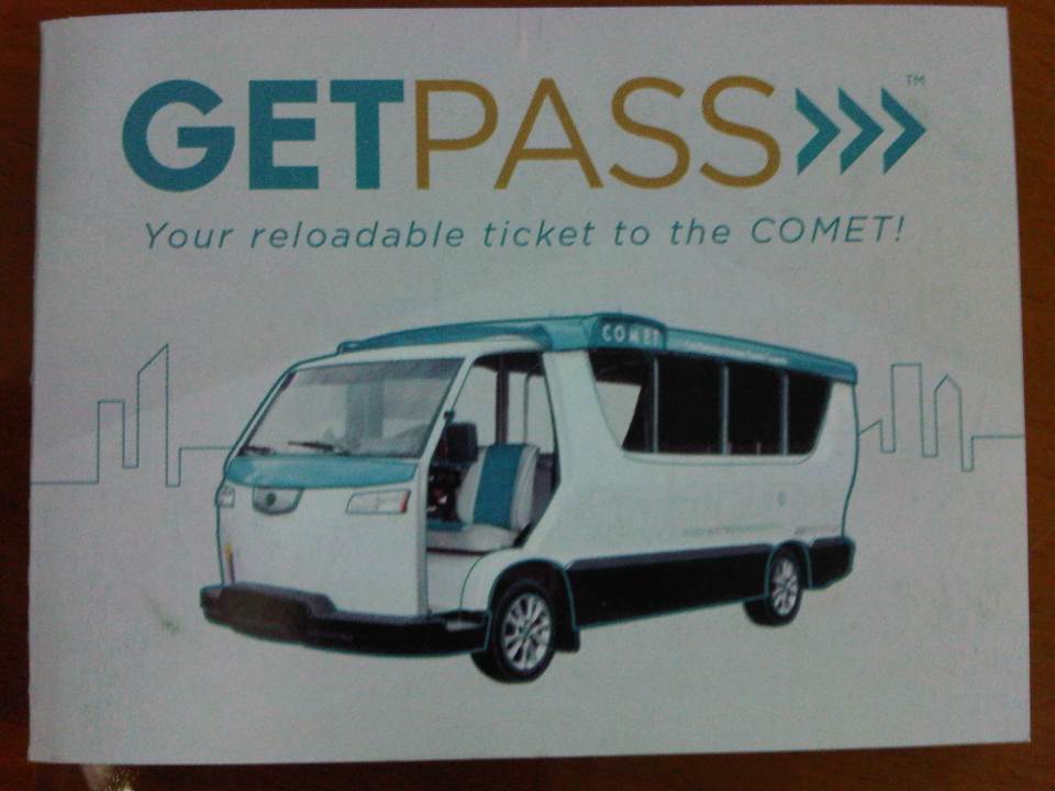 The GETPass card comes with a brochure on the COMET and how to use the card.
 Basic information on the GETPass card.
 Illustrative example of how to use the card.
 The GETPass card
 Instructions at the back of the card.
 More information on Global Electric Transport.
 Southbound designated stops for the COMET.
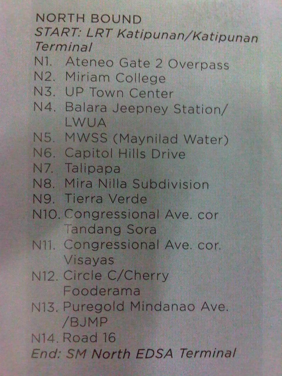 Northbound designated stops for the COMET.
 Route map included with the tap card brochure.
 COMET in operation along the southbound side of Katipunan Avenue (C-5).
The current experimental route of the COMET overlaps with several jeepney routes including Katipunan and Tandang Sora jeepneys. If the objective is simply to demonstrate vehicle performance (and reliability) using this route and with actual traffic conditions, then this would be a very fruitful exercise. However, more suitable routes should be considered for the COMET including possibly new routes like missionary routes or feeder routes that are not yet served by any formal public transport. This is one way for the COMET to be mainstreamed and for the low emission vehicle to have a significant impact on transport and environment. Another way that would certainly be the more challenging one is the prospect of the vehicle replacing conventional jeepneys along established routes. I say this is a challenge because there has been a need to retire or phase out conventional jeepneys in favor of higher capacity modes (i.e., bus) and the jeepney sector (operators and drivers) have always been somewhat averse to proposals modernizing jeepneys due in part to financial implications of transitioning to low emission options like the e-jeepney or the COMET. If these are not considered, the COMET will just be an additional vehicle along Metro Manila’s streets, contributing to the chaotic road public transport, and its hyped benefits will not be realised.
I do hope that the COMET will not be just another paratransit mode that is integrated with all the other land transport modes currently in operation throughout the country. I believe there is a big potential for the vehicle and similar other models like it for cities and towns that are not yet as highly urbanized as Metro Manila or perhaps Cebu. There are corridors or areas where buses are not or will not be viable within the foreseeable future (next 5 to 10 years?) given the demand for this period. These are where jeepneys thrive (assuming tricycle operations are restricted or strictly regulated) and where the COMET would be most suitable.
–
Interesting articles on traffic congestion
Here are a few good reads on traffic congestion and its measurement or quantification:
- How Not To Measure Traffic Congestion—Hold the Hyperbole, Please! which appears on Planetizen today, October 15, 2014.
- Rethinking the economics of traffic congestion which appeared on June 1, 2012.
Reading these articles will probably make you think that traffic is good or that congestion is good. While congestion is indeed indicative of economic vibrance as movement of people and goods are a good measure for economic activity, excessive congestion results in many other problems that need to be addressed and which can also be quantified in economic terms. Note, too, that one author mentions “peak traffic” that is now becoming common in developed countries as motorization has plateaued and transport systems have become developed to provide people and goods with a variety of modes to choose from including walking and cycling. In our case, traffic has not yet “peaked” in the sense that motorization continues for many of our cities including Metro Manila. There is also a lag in the provision of transport infrastructure including mass transit systems that should have been constructed decades if not years ago. Perhaps we need to be clear about the context by which congestion costs are estimated and presented.
The somewhat dramatic presentations like the manner shown in the first article above reminds us of similar estimates of congestion costs in the Philippines, particularly for Metro Manila. The latest of these come from a JICA project that had as an objective the drafting of a roadmap for transport in the expanded region that is dubbed as Mega Manila (Region 3, National Capital Region and Region 4A). The end product has been billed as a “Dream Plan for Mega Manila” and draws on congestion cost estimates that would definitely be regarded as exaggerated if seen in the context of the two articles we mentioned above. Perhaps it is the important message (i.e., we need to build transport infrastructure) of such exaggerated presentations that we should focus on an not really the specific numbers being quoted by news organizations and circulated in social media.
We have to caution the reader that congestion is here to stay and cannot be totally eliminated, especially with economically vibrant or growing cities. What we probably would like to address, however, is excessive congestion. Yes, there is such a thing as excessive congestion. I would like to describe this as something that is “unreasonable” along the lines of say instead of your regular 1 hour commute, it took you 2 hours or more. For some, this can be due to horrendous traffic jams due to flooded streets. Or perhaps someone who takes public transport waiting for hours just to get a ride. And so people are forced to cope and in a way, their minds have been conditioned to tolerate (accept?) the levels of congestion they experience on a daily basis. Congestion is good but it does not have to be hellish.
–
