
Home » Transport Planning (Page 8)
Category Archives: Transport Planning
On roadway expansions and induced demand
We start December with another shared article. Here is another excellent article from Todd Litman about roadway expansions and induced demand:
Litman, T. (November 28, 2021) “The Roadway Expansion Paradox,” Planetizen.com, https://www.planetizen.com/blogs/115395-roadway-expansion-paradox?utm_source=newswire&utm_medium=email&utm_campaign=news-12022021&mc_cid=89cc0b2638&mc_eid=9ccfe464b1 [Last accessed: 12/3/2021]
Note the list of references at the end of the article for further reading.
–
On the key transformations needed to achieve sustainable, low carbon transport
Also related to COP26, I am sharing material from the Sustainable Low Carbon Transport (SLOCAT) partnership, of which our center is part of. SLOCAT recently released the 11 key transformations for sustainable low carbon land transport urgently needed to meet the climate targets. Here’s a link to their site:
SLOCAT also has the following Wheel of Transport and the Sustainable Development Goals (SDG’s) on the same site. The Wheel illustrates the four cross-cutting themes: equitable, healthy, resilient and green.
In the SLOCAT site, they list the following to support the transformations:
Overarching approaches to apply across transport modes and sub-sectors overtime
- Put people first, not vehicles and technology
- Co-create and communicate a compelling vision and targets
- Guide short- and medium-term action with clear, coherent political messages
- Combine push and pull measures: Regulate and incentivise
- Link policies within and beyond transport for synergies
- Prioritise resources by social and sustainable value for money
- Engage, empower and coordinate stakeholders across government levels and sectors
- Build capacity and improve data
- Implement pilots to learn and share, then roll out at scale
–
On housing and transportation
I’ve written about how we should not be trying to isolate transportation as if it is singly at fault for the transport and traffic mess many of us are in at present. There are many factors affecting travel behavior including mode choice. Travel distances, travel times and mode choices are not a consequence of transportation system (including infrastructure) alone. Land development and pricing especially those pertaining to housing are critical in how people decide where to live. These are intertwined with transportation and can be quite complex without the proper data or information to help us understand the relationship. That understanding, we are to assume, should lead us to the formulation of policies intended to correct unwanted trends and perhaps encourage more compact developments that are closer to desirable concepts such as the 15-minute city.
Here is an interesting article to enrich the discussion on this topic:
Dion, R. (October 28, 2021) “Coupling Housing and Mobility: A Radical Rethink for Freeways,” Planetizen.com, https://www.planetizen.com/features/115126-coupling-housing-and-mobility-radical-rethink-freeways?utm_source=newswire&utm_medium=email&utm_campaign=news-11012021&mc_cid=85ec2b565f&mc_eid=9ccfe464b1%5BLast accessed: 11/3/2021]
The first thing that came to my mind are residents of northern and southern Metro Manila and the surrounding provinces. Many chose to buy houses there and beyond (i.e., Bulacan, Laguna and Cavite) and yet work or study in Metro Manila CBDs like Makati, Ortigas and BGC. And they do use the tollways (e.g., NLEX, SLEX, CaviTEX, Skyway) to get to their workplaces and schools.
This is also a relevant and timely topic in the Philippines as many cities are already headed for sprawls that will inevitably put more pressure on transportation infrastructure development that usually leans towards car-oriented projects (e.g., road widening, new roads, flyovers, etc.) rather than people-oriented ones (e.g., modern public transportation systems, bikeways, pedestrian infrastructure). Note that only Tokyo has developed an extensive enough railway system to cover the sprawl that is the Tokyo Metropolitan Area, which if interpreted loosely also includes Yokohama, Kawasaki and Chiba in the sprawl. No, we cannot build as fast to have as dense a railway network as Tokyo’s or other cities with similar rail systems. And so we have to figure out another way to address this problem.
–
Parking: minimum or maximum
The National Building Code (NBC) of the Philippines stipulates the minimum number of parking spaces or slots per type of establishment and intensity of development (i.e., according to area or other parameters). These established provisions are generally called parking minimums. The NBC’s provisions are already archaic by current standards and need to be revised but not in the way it was apparently developed. The NBC needs supporting evidence from studies (are there any dependable ones around?) on parking requirements including those for bicycles and motorcycles. These should clearly not include or impede the requirements of pedestrians. And local government units must be required to enforce these NBC provisions.
Here is an article that discusses the proposal for new limits on parking, particularly in large developments in Boston, Ma. in the US:
The article points to this one:
City of Boston (September 20, 2021) Maximum Parking Ratios, https://www.boston.gov/departments/transportation/maximum-parking-ratios [Last accessed: 10/19/2021]
I must admit that I still have to do a lot of reading on this. There are some who are calling for the abolition of parking minimums but you just can’t do this so abruptly without understanding the context and current set-up. We are not Boston or San Francisco or Hong Kong or Singapore in terms of the transport infrastructure and services and the progressiveness of policies including those governing or covering housing and other factors that come into play with transportation. Sprawl and the resulting pressures (requirements for efficient travel) on the transportation system is not transport’s fault or responsibility alone like what some articles or infographics make it appear to be. It is very much about land use and land development, and the policies and the political economy behind these developments.
–
We need to do more to reduce transport emissions
I did some work on long term action plans on low carbon transport for the ASEAN region before. We were able identify many of interventions that were being implemented as well as those that can be done to reduce transport emissions. Such reductions for the region would ultimately contribute to alleviating global warming. Unfortunately, while ASEAN is a significant contributor to emissions, it pales in comparison to emissions by individual countries like China and the US. If these two and others in the industrialized world do not commit to reducing their emissions, all work will come to naught. Here is an article that serves as a pre-event write-up for COP26, a major climate summit that will be held in Glasgow in the coming days.
–
On an ‘induced demand calculator’
Induced demand or traffic is a popular topic these days thanks to the proposal of a private company to build an elevated tollway along the Pasig River. The topic is also much in circulation the past few years as the DPWH’s part in the government’s Build, Build, Build program has road widening as a major component. There are many completed, ongoing and planned projects across the country that involves road widening, particularly increasing the number of lanes of typical national roads from 2 to 4, not counting the shoulders (paved or unpaved). The results are mixed as there are roads that definitely required capacity increase in the form of additional lanes, and there were roads that did not require them. The latter were still expanded and perhaps the agency did so because their key performance indicators basically obliged them to undertake such projects regardless of the need. Somehow, these were justified and yet there were and are many questionable road widening projects especially those that involved the cutting of decades if not century old trees (e.g., the Kamatchile and Acacia trees that used to line up long sections of national roads in Tarlac are no more) or the demolition of heritage structures such as houses.
A came upon this article about an “Induced Demand Calculator” developed in the US. I have not gone through the calculator itself but such a tool could be quite useful in quantifying the impacts of road widening while pushing for other options to improve transportation and traffic that is not the typical “solving traffic” type of approach. Here is the article in Streets Blog:
I am not aware if there are similar tools being developed here. Such a calculator will require data from various sectors including construction costs, operations and maintenance costs, value of time and current and projected vehicular and person trips that can be translated into traffic volumes.
–
Is it difficult to understand the phenomena of induced demand?
I’m sharing a recent article that laments about how transport departments in the US seemingly don’t understand the concept and phenomena of induced demand. Is it really difficult to understand or are transport officials including highway planners and engineers deliberately ignoring what’s staring them in the face?
Zipper, D. (September 28, 2021) “The Unstoppable Appeal of Highway Expansion,” Bloomberg City Lab, https://www.bloomberg.com/news/features/2021-09-28/why-widening-highways-doesn-t-bring-traffic-relief [Last accessed: 10/10/2021]

The topic in the article is very much applicable to our own Department of Public Works and Highways (DPWH). The DPWH’s key performance indicators (KPIs) need to change from the typical “kilometers of road constructed” or “lane-kilometers of roads widened” to something like “travel time between points A and B”. Agencies like the DPWH always like to claim they are for solving traffic congestion but we already know widening roads just won’t cut it. It has to be more comprehensive than that and involve the entire transport system rather than just a part (i.e., the road). And it has to be a collaborative effort with various other agencies like the Department of Transportation (DOTr) and local government units. Unfortunately, too, these agencies like the DOTr and those under it, and many (not all) LGUs also like to go at it solo so we end up with piecemeal solutions that are also often out of context.
–
On rethinking transit for our cities
There’s a nice article recently published on The New York Times. It’s about how cities have been rethinking and developing their transit systems in light of climate change and the pandemic. Here is the article:
An interesting part of the article is on the call for the return of trams or street-level trains. These are very similar to the tranvia that used to be the preferred mode of public transport before World War 2. Would that be possible to build now in Metro Manila? Perhaps it would be a bit more challenging given the development but there are definitely corridors or areas where you can have trams…if the government wanted to. Among those would be along the Pasig River if the development will be similar to the esplanade and enough ROW can be acquired and allocated for these street-level transport. There is also the Botocan ROW, which we actually studied many years ago for Meralco, for the feasibility of a street-level transit system stretching from Katipunan to Quezon Institute. It could have been the revival of Meralco’s rail division of old.
What do you think?
–
Why not rationalize other routes now?
There is an enduring discussion in various forums and platforms about the lack of supply of public transportation. I can’t help but notice though that many discussions consciously or unconsciously leave out the part of public transport rationalisation that calls for phasing out lower capacity vehicles in favour of higher capacity ones. I have written about this and explained the necessity particularly along corridors with high transport demand. Delaying what is required (not necessarily what is inevitable) means we fall short of transforming public transport services in this context.
There are definitely missed opportunities here but the current discussions and proposed resources for 2021 including funds for service contracting seems to suggest a status quo in terms of vehicles with the exception of the modernisation part. Perhaps this is because we are still in pandemic mode and survival is still the name of the game? Nevertheless, there should be initiatives and continued dialogue about ‘graduating’ from lower capacity vehicles to higher capacity ones. Of course, this discussion is more urgent for highly urbanised cities than smaller ones.
–
On defining the 15-minute city
I have shared articles and briefly written about the concept of the 15-minute city on this blog. Here is another discussing how a 15-minute city is defined:
(February 8, 2021) “Defining the 15-minute city,” Public Square, https://www.cnu.org/publicsquare/2021/02/08/defining-15-minute-city [Last accessed: 8/10/2021]
Here is an image from the article:
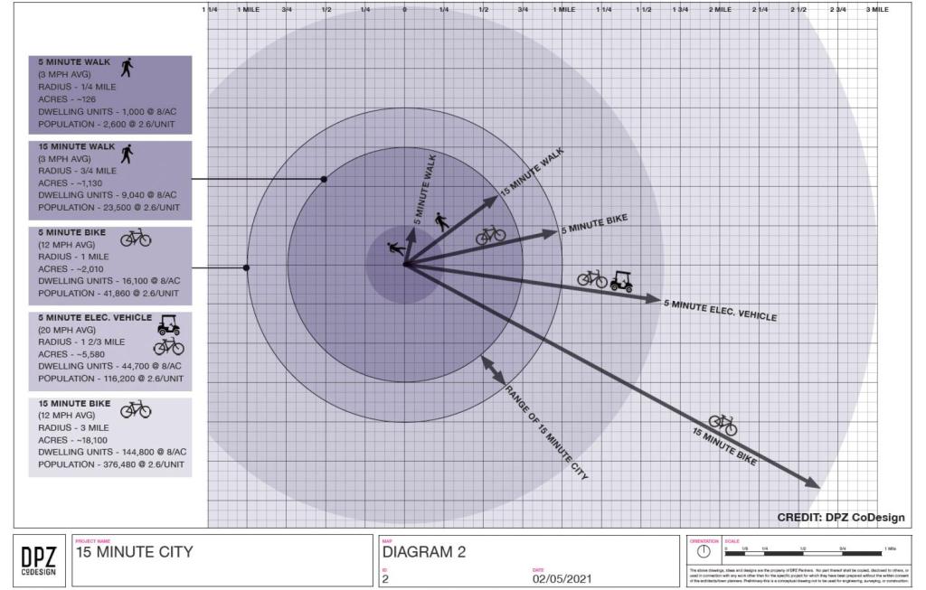
Again, it is important to contextualize these concepts. I share these as references and topics for discussion. Of course, I have my own opinions about this and I have written about those in previous posts. I guess in the Philippine context, we can include the pedicab or non-motorized three-wheelers in the discussion. These are also very popular modes in many cities and municipalities despite their being also prohibited along national roads like their motorized counterparts. It would be nice to have more visuals in the form of maps that show travel times for essential destinations or places like hospitals, markets, grocery stores, workplaces and, of course, homes. I assume there is at least someone, somewhere who perhaps have made multi-layer maps of this sort and attempted to related them along the lines of this concept of a 15-minute city (or perhaps the even older “compact cities”).
–
