
Home » Posts tagged 'cityscapes'
Tag Archives: cityscapes
A cityscape revisited
I was posting photos of a familiar sight along one of my walking routes in our neighborhood. Somehow, that route became less frequented as houses were constructed in what old timers here referred to as the second floor. What offered a 360 view of areas surrounding our place was now mostly inaccessible, depriving people of spectacular views.
Last Sunday, we chanced upon the sight below along another of my routes that we now seldom passed.
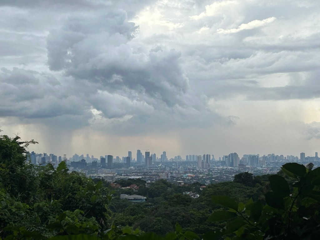
The place where I took the photo will probably also be inaccessible soon as we saw the lots being cleared for construction. We missed the views and soon they’ll be just memories or photos stored in our gadgets.
–
Traffic and the changing Katipunan cityscape
The traffic situation along Katipunan Avenue has worsened over the years. While there was some respite from the usual congestion experienced along the stretch of interest that has 3 major schools and a mall during the pandemic, ‘traffic’ is back with a vengeance and the new normal seems worse than the old. That Katipunan has changed a lot over the decades is an understatement. The photo below shows high rise buildings completed and under construction. All of these are residential condominiums along Katipunan and Xavierville. Many students now reside there and walk, cycle or take public transport to school. Enrollment though at Ateneo, Miriam and UP has also increased over the years. That means more trips generated by the schools. And with many still dependent on cars for their commutes, it is no wonder that the traffic situation is usually hellish especially during the peak hours.
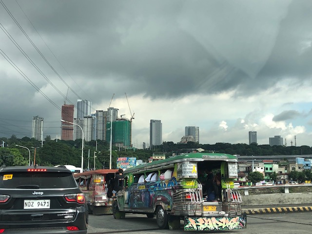 I took this photo while stopped in traffic at the SM Marikina service road one morning. I have been commuting along this route since the late 1980s and at that time, there were no tall buildings along Katipunan. However, traffic was already bad especially along the stretch from Aurora Boulevard to C.P. Garcia. Its worse now from what I have observed and experienced these 35 years.
There will likely be more condos to be built in that area. The question is if these will lead to more people walking, cycling or using public transport, and becoming less car-dependent. What are the travel characteristics of people there? How much is through traffic?
–
Cool Walkability Planning
I am sharing this article about planning and design for more walkable streets. The term ‘cool’ in the article refers to temperatures as people are less likely to walk if it is too hot to do so.
From the article:
“Improving walkability (including variants such as wheelchairs, hand carts, low-speed scooters) can provide significant benefits to people, businesses and communities, particularly in dense urban areas where land values are high and vehicle travel is costly. However, walking can be uncomfortable and unhealthy in hot climate cities, particularly those that often experience extreme temperatures (over 40° Celsius, 105° Fahrenheit). These conditions make walking unattractive and infeasible during many days…
A well-planned networks of shadeways (shaded sidewalks) and pedways (enclosed, climate-controlled walkways) incorporated into a compact urban village can provide convenient, comfortable and efficient non-auto access during extreme heat. They can create multimodal communities where residents, workers and visitors rely more on walking and public transit, reduce vehicle use, save on vehicle costs, and require less expensive road and parking infrastructure…
The main obstacle to comprehensive pedway development is the well-entrenched biases that favor motorized travel and undervalue non-motorized modes in transportation planning and investment. Transportation agencies have tools for planning and evaluating roadway improvements, and funding to implement them, but lack comparable tools and funding for walkability improvements such as shadeways and pedways, even if they are more cost effective and beneficial than roadway projects.”
Source: Cool Walkability Planning
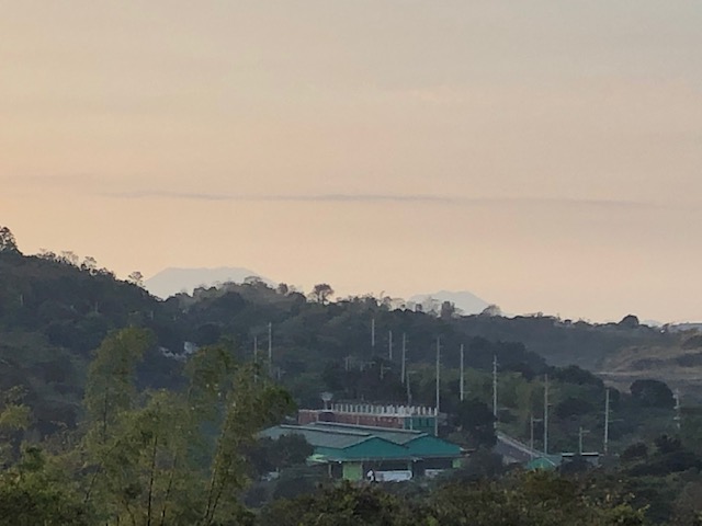
Cityscapes and mountains
I’ve been reading about how a lot of people seem to be ‘discovering’ the mountains around Metro Manila. It is not as if these have suddenly appeared or that many have been obscured by pollution. For the latter, perhaps if you lived some distance and pollution was so bad that the smog was thick enough to hide mountains then it would be easier to not see them. In reality, I think most of these people have just been too busy not to see these mountains and other landscapes when they happen to be in plain sight. Perhaps people were too distracted by their daily routines that they didn’t have time or relegated these to the background as if they were noise to be filtered. Parts of the Sierra Madre from Antipolo to San Mateo and Rodriguez (Montalban) are common sights that are not usually appreciated as people go on their daily commutes and are caught in traffic.
Here are some of the mountains that are visible from strategic locations. In my case, I live in Antipolo and an area near my home allows me to see well known mountain landmarks from different provinces.
 Mt. Makiling in Laguna Province without the usual cloud cover of its peak
 Mt. Banahaw and Mt. San Cristobal in Quezon Province are not usually visible unless its really one of those clear days.
 Mt. Arayat in Pampanga Province is visible at the right side of the photo. The view though is marred by rebars sticking out from a house under construction.
 Mt. Mariveles in Bataan Province with cloud cover serves as a background for the Metro Manila cityscape.
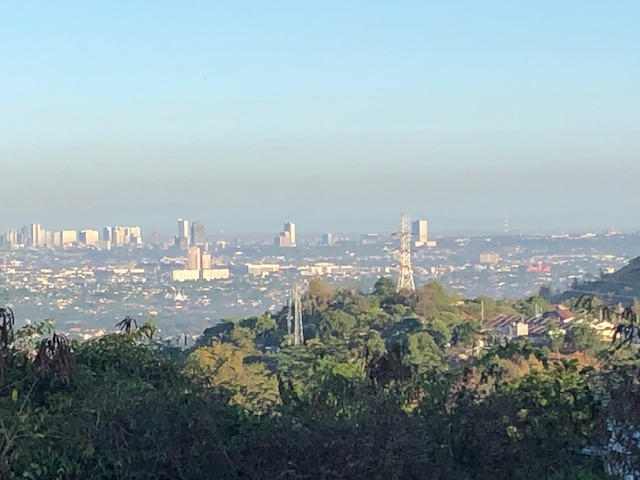 This is what Quezon City usually looks like with layers of smog making it difficult to ascertain any mountains that are visible on clear days.
I have photos of Mt. Natib, Mt. Malarayat and the Tagaytay Ridge that I will be posting here soon.
–
