
Home » Posts tagged 'intersections'
Tag Archives: intersections
Complicated intersections in Rizal – Tikling Junction
There are several major intersections in Rizal Province. Among them are 3 junctions in Cainta, Taytay and Antipolo – Cainta Junction (Ortigas Ave Ext.-Felix Ave), Masinag Junction (Marcos Highway-Sumulong Highway), and Tikling or Kaytikling Junction. The first two are signalized intersections. The last one is supposed to be a roundabout. All three are problematic in various ways and have been associated with congestion along the major roads intersecting at these junctions.
Tikling is quite interesting as traffic seems to have worsened after it was set up as a roundabout. Taytay enforcers have been deployed here but they seem to contribute more to worsening congestion rather than easing it. Motorists familiar with the area will tell you that traffic is better when there are no enforcers. Unfortunately, not all motorists here are from the area or are familiar with the rules for navigating or positioning at a roundabout. And so the intersection is often constricted with vehicles whose drivers and riders don’t practice courtesy.
Perhaps a combination of geometric improvements and more clever enforcement/management can improve intersection performance?
–
On roundabouts and how they can improve safety at intersections
Roundabouts are perhaps something that should be considered for Philippine roads. The concern, however, is that Philippine drivers don’t know how to navigate or position themselves in roundabouts. And the results as we have seen in several cases are congested roundabouts or rotundas.
AASHTO (September 26, 2025) “State DOTs Highlight How Roundabouts Improve Safety,” AASHTO Journal, https://aashtojournal.transportation.org/state-dots-highlight-how-roundabouts-improve-safety/%5BLast accessed: 10/19/2025]
To quote from the article:
“To highlight the safety benefits of roundabouts, the Ohio Department of Transportation recently released an analysis of crash data from 76 intersections statewide that had been converted to roundabouts. That analysis indicated single lane roundabouts decreased injury crashes by 69 percent while multi-lane roundabouts resulted in a 25 percent decline.”
And here another quotable from the same article:
“For us, it’s simple. Roundabouts remove cross-traffic turns and eliminate T-bone crashes, while improving traffic flow,” said PennDOT Secretary Mike Carroll …”“Any design that dramatically reduces the most serious crashes we see on the road is worthy of consideration in our projects.”
The article also includes a YouTube video on traffic circles.
–
Complex intersections in Davao City
My first project upon my return from Japan in 1999 was the Davao City Transportation and Traffic Management Plan Study. We found a few interesting intersections there. These included junctions with more than 4 legs. If all or most movements were allowed at these intersections, they would be most complicated and risky due to the number of conflicts. Of course, not all movements are allowed and many legs are one-way meaning there are fewer conflicts and less risky.
 These intersections are large and while there are traffic signals, they were off when I was there.
 Surprisingly, there was no congestion or near crashes. Either, traffic was light at the time (before 7AM) or motorists were driving at a level similar to Vietnam (where vehicles were like ants as they moved at intersections).
A bit of trivia here – 1999 to 2002 was the only period in a long time when a Duterte was not mayor of the city. This was the time the former president relinquished the mayoralty in favor of his Vice Mayor and was instead congressman representing the city. He immediately returned after one term rather than serve out 3 terms.
–
Foggy roads – Part 2
This is supposed to be a follow-up to the post on foggy roads in Tagaytay last month. Unfortunately, I could other things came in the way of finishing this Part 2. Intersections can be quite dangerous if all approaching one have limited visibility. Add to that the flaws in intersection geometry that may contribute to it being risky to travelers. Following is an example along the Tagaytay-Calamba Road with an intersection with Belleview Drive, which is the main access road to Tagaytay Highlands.
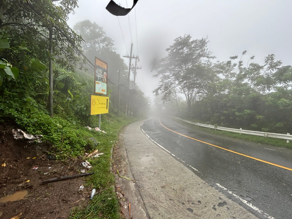 The approach from Tagaytay features a curve. I didn’t notice any streetlights along the road so I can imagine it must be poorly lit at night. What more if there is a thick fog in the area?
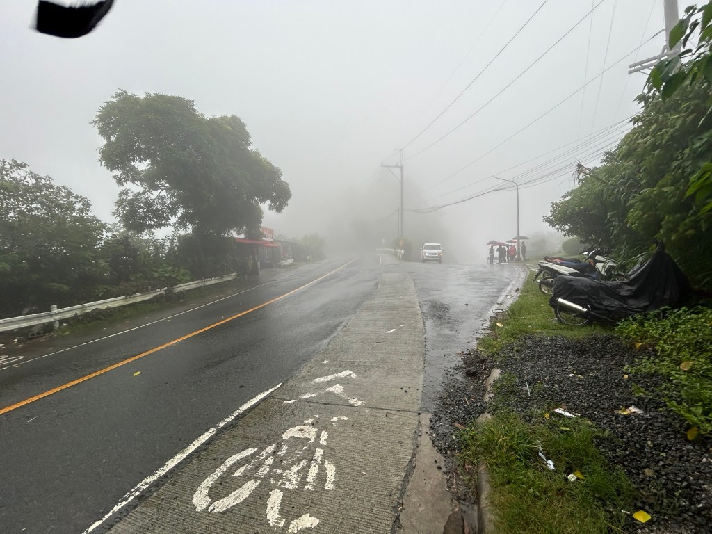 The bike lane is a product of the government’s efforts to come up with a bike lane network along national roads during the pandemic. This is actually the shoulder painted to become a bike lane. This is the view of the intersection approach if you’re coming from Tagaytay. The leg to the right with the people with umbrellas is Belleview Drive and towards Tagaytay Highlands. You can easily miss this if you were not familiar with the area and cruising along the highway. Note the thick fog obscuring your vision of the intersection. The curvature to the left also adds to the complex situation.
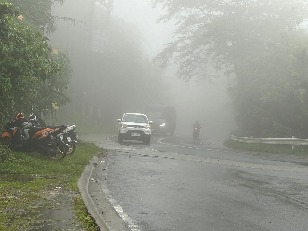 This is a closer look at the highway approach from Tagaytay taken a few minutes after I took the first photo in the article. Note the fog quickly setting in and the limited visibility. The motorcycle moving away from us would disappear into the fog. This is during the daytime and supposedly in broad daylight. Vehicles would need to turn on their lights so others may see them on the road.
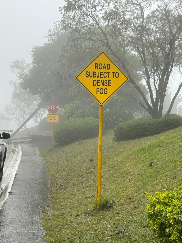 The sign along Belleview Drive states the obvious. There should be more signs like this located strategically along the Tagaytay – Calamba Road and others usually cloaked in the fog we experienced in Tagaytay recently.
I assume there would be similar situations elsewhere including in Baguio City. We also experienced fog (not smog) in Antipolo but these were quick to dissipate unlike the ones in Tagaytay and Baguio.
–
Zamboanga’s first flyover
We passed by the construction site of Zamboanga City’s first flyover at the intersection of the Pan Philippine Highway (AH 26) and Veteran’s Avenue. I recall there was a lot of pressure from DPWH for the city to approve its construction. The previous mayor didn’t want to approve the project because the perception was that it was not required and there were other options to consider before a flyover was to be constructed. However, many people including the then congressman and now mayor probably thought the flyover would be the solution to the congestion experienced at the intersection. Add to that the perception that the flyover is also somewhat a symbol of progress.


We won’t know until its completion and the ‘normalization’ of traffic in the area to determine whether the flyover has ‘solved’ traffic congestion in the area. The problem with this approach to ‘solving traffic’ is that it is usually a short-lived alleviation of a symptom of the real problem, which is transportation. Zamboanga City has deferred rationalization of public transport routed despite analysis and plans pointing to a streamlined and optimized transportation system if this was pursued. The City commissioned a Transportation and Traffic Management Plan Study in the previous administration but the plan and its recommendations have been shelved, another example of such being casualties of a change in administration of an LGU.
–
On making intersections safe by ‘daylighting’
I came across this interesting article that introduced a somewhat new term to me – daylighting.
Abramson, B. (November 24, 2023) “How to Daylight Your City’s Intersections (and Why It Matters),” Strong Towns, https://www.strongtowns.org/journal/2023/11/24/how-to-daylight-your-citys-intersections-and-why-it-matters [Last accessed: 12/3/2023]
From the article:
“Daylighting is the technical term for a common-sense solution to traffic safety: By removing visual obstructions in approaching intersections, users can better see and more safely cross each other’s paths. “
There are certainly many intersections and even mid-block crossings in our cities and municipalities that could use ‘daylighting’ to improve safety. Many of these intersections and crossings are used by the most vulnerable road users like children, senior citizens and persons with disabilities. Interventions need not be expensive and may also involve the community. Examples are shown in the article, and these can easily be implemented formally or informally with the cooperation of stakeholders including the local government units and national agencies (i.e., DPWH) under whose jurisdiction many roads are.
–
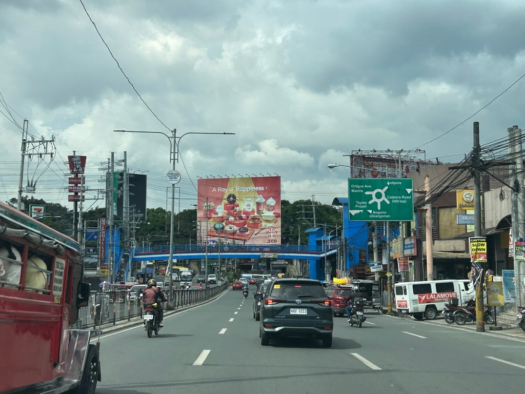
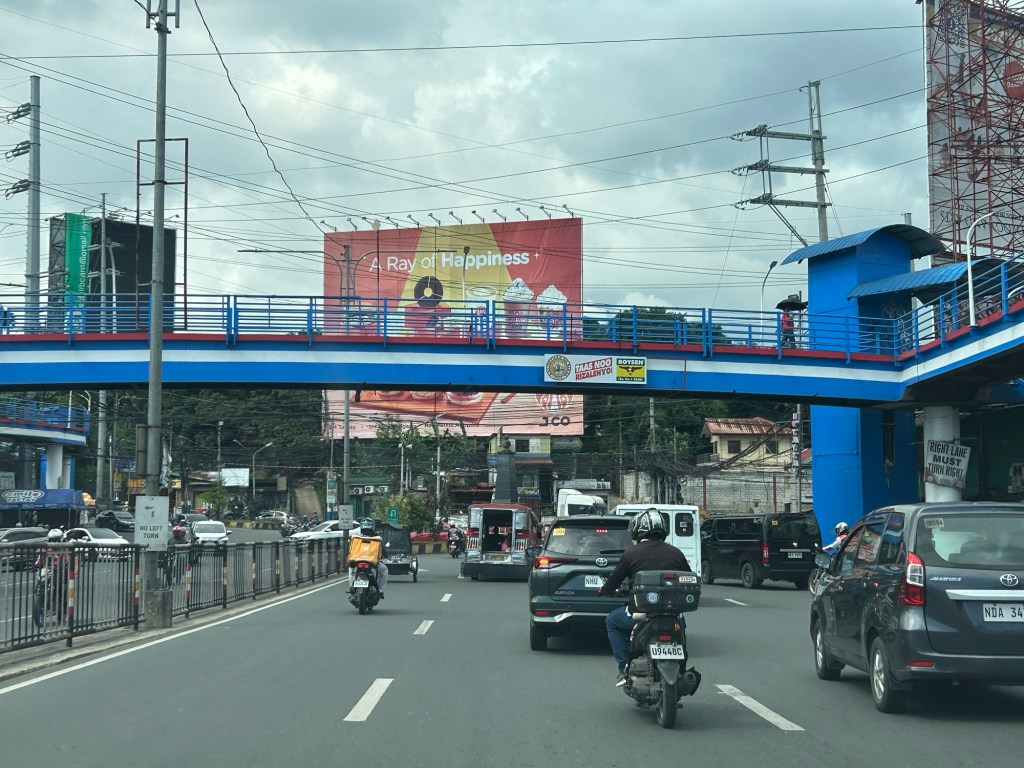
Tikling junction traffic
Easily a pet peeve along my commute is Tikling or Kaytikling Junction in Taytay, Rizal. I think traffic here is worse than two other major junctions in Rizal Province – Cainta Junction and Masinag Junction in Antipolo City. And that is because of the combination of traffic management (or mismanagement) by elements of the Taytay Municipal Government and motorists lack of understanding of how vehicles should position (or travel) at roundabouts. Of course, the volume of motor vehicle traffic converging at this junction would probably merit traffic signals over a roundabout but for most times when there are no enforcers here, traffic is somewhat more efficiently flowing as drivers and riders are forced to give way in order to not constrict traffic.
 Enforcers often employ the “buhos” system of prioritizing traffic for one leg at a time. However, instead of a quick transition from one leg to another, they tend to give more time to vehicles coming out of the Manila East Road and turning left and (west)bound for Ortigas Avenue Extension. The long time allocated to the latter means long queues for traffic coming down from Antipolo and those from Cainta.
 Enforcers are partial to outbound traffic from Taytay rather than make an effort to have more equitable ‘go’ time for all legs at the junction.
One wonders who is in charge of traffic for Taytay considering they mismanage traffic everyday. [Though I also wonder why the rest of Rizal including Antipolo and Cainta can’t seem to be bothered by the congestion emanating from Tikling.] As if to prove the point of incompetence, another problematic intersection is the Highway 2000 – Barkadahan Bridge – East bank road intersection, which is signalized and yet somehow always congested (or saturated). But that’s another story.
–
Counting cars: ideal vantage points for intersections and elevated highways
The weekend found us staying at a hotel in Makati in order to be near the recital venue for our daughter. Our room afforded a nice view of the surrounding areas (we were on the 29th floor) but the traffic engineer in me gave in to the temptation to take photos of a major intersection nearby – the Gil Puyat Avenue – Ayala Avenue intersection. These are two of the most prominent streets in the Makati CBD and strategically located at one corner is the Makati City Central Post Office and a stone’s throw away is the Makati City Central Fire Station. At another corner is the RCBC tower that hosts foreign embassies including the offices of the European Union.
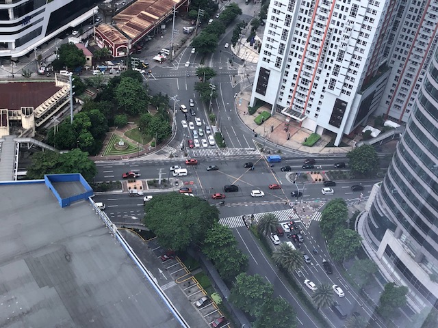 Intersection of Gil Puyat Avenue (formerly Buendia Avenue) and Ayala Avenue
 A view of the skyway in the distance
The view of the intersection gave some flashbacks to times when I was a student and a young researcher who had to find good vantage points for collecting traffic data particularly for intersections. Aside from the movements and the corresponding counts, the junction configuration can clearly be seen from the top and useful for developing models for analysis. There was a time when we coveted such views for traffic simulation. You can can install a camera so that you can record hours of footage to use for data extraction. The video recording also allowed one to revisit the footage in case there are questions regarding the data. The same videos can also be used for image processing for more automated, even intelligent or smart data collection using computers.
–
