
Home » Posts tagged 'Land use'
Tag Archives: Land use
On affordable housing
I’ve written about the relationship between transportation and housing in many of my previous posts. Here is an article defining affordable housing from the US context:
Axel-Lute, M. (January 23, 2025) “What is ‘affordable housing’?” Shelterforce, https://shelterforce.org/2025/01/23/what-is-affordable-housing/ [Last accessed: 2/4/2025]
To quote from the article:
“With no other qualifications, “affordable housing” in the United States typically refers to housing whose cost is affordable to households that make somewhere between 40 and 80 percent of the area median income.
Below 80 percent of AMI is how the U.S. Department of Housing and Urban Development officially defines “low income”—but be careful about making assumptions. Area median incomes are calculated at the metropolitan level, so for many areas they can be quite high. In those cases, “affordable housing” might be targeted to people who wouldn’t have considered themselves low income.
On the other hand, in some less affluent neighborhoods, official “affordable housing” might be too expensive for most of the people who already live there. And in metropolitan areas with lower housing costs overall, official “affordable housing” might not be much cheaper than market rate!”
How do we define affordable housing in the Philippines? Is our definition of “low income” similar to how they define it in the US or elsewhere? Or are our definitions flawed and therefore affect how we provide (or not) housing to those who need them the most?
–
Back in Iloilo (again) and a note on landmarks
One landmark that I have been familiar with since I was a child is the Jaro Cathedral belfry. The building is located at the plaza across from the church. The area has been neglected for a long time and I am glad to see the city developing the area to become more attractive and useful as a park for the benefit of its citizens and visitors.
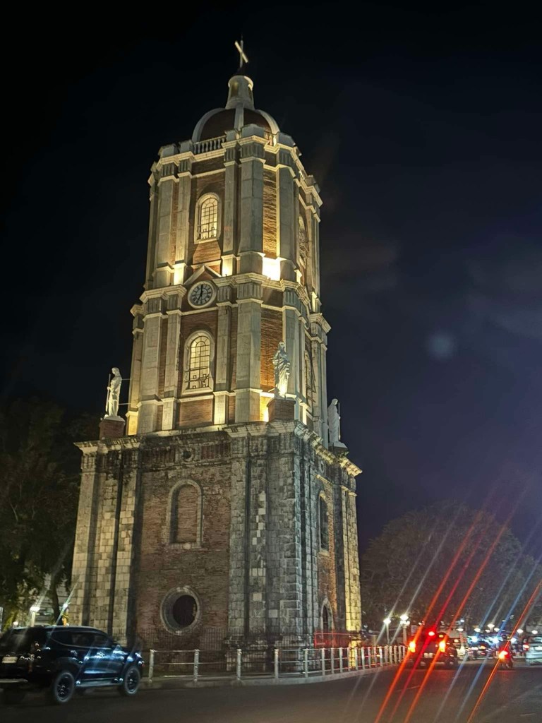
The area, I’ve been told, is being developed as part of a program towards coming up with more open spaces like parks particularly where there are already plazas around the city. I have memories of getting a ride back to my father’s hometown whenever we went to the city usually to eat or shop. The informal jeepney terminals used be around the plaza. Other jeepneys rounded the streets for their return trips instead of stopping at a terminal. Now you have to travel to the provincial jeepney terminals at the outskirts of the city to get a ride to the other towns.
–
Back in Tagaytay
It’s been a while since I’ve been to Tagaytay. I think the last time was before the pandemic and with family. There used to be a time when we went there at least every month not counting the seminars and workshops we attended there. It was an easy drive from our home in Antipolo to Tagaytay via C6, SLEX and the Sta. Rosa-Tagaytay Road. We had our favorite stopovers with breakfasts usually at the Paseo de Sta. Rosa. Later, as Tagaytay became more crowded and congested, the trips became fewer. Of course, our schedules also became busier but then it wasn’t like we looked forward to the traffic and the crowded attractions there. I’m doing a project there now with my team at the office and that means I get to go there for work. Since we’ll be there anyway, we could have some side trips to eat some good meals (bulalo!) and maybe take some photos of Taal volcano.
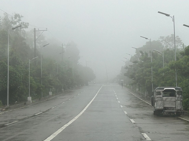
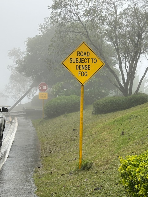
The fog was a quick reminder of the Tagaytay of old that we frequented before. But what we noticed was that it wasn’t cool. It was still somewhat warm if there was no breeze or wind blowing. This was certainly not smog as you can smell the pollution if it was. We even joked that it probably wasn’t because of the volcano as the smell of sulphur would probably be strong. We were in Tagaytay during the weekdays so there were fewer people and traffic. We were told that it was worse on weekends. That was to be expected. And with CALAX, Tagaytay became more accessible to visitors. I will write about the developments there in the next post. I feel there’s just too many buildings and the intense development has made Tagaytay less attractive. I have similar memories and feelings about Baguio but that’s another story to tell or write about.
–
Article share: on making more affordable neighborhoods
I’ve been commenting about how transportation cannot be isolated and the need to relate it to other factors such as housing or home location choice. The latter though is also affected by other factors as well that affect the affordability of homes near the city centers or CBDs where workplaces and schools are located. The result of course is sprawl or the encouragement of sprawl. Private companies take advantage of this or contribute to this ‘encouragement’ by developing land farther away from the center. Thus, for Metro Manila’s case, many people reside in the peripheral provinces of Bulacan, Rizal, Laguna and Cavite. There are even those who choose to reside in Pampanga, Bataan and Batangas.
Kayatekin, C.S. and Sanmiguel, L.U. (April 16, 2024) ” ‘Urban form’ and the housing crisis: can streets and buildings make a neighborhood more affordable?” The Conversation, https://theconversation.com/urban-form-and-the-housing-crisis-can-streets-and-buildings-make-a-neighbourhood-more-affordable-224108 [Last accessed: 4/23/2024]
Quoting from the article:
“Our main finding was that the bottom-up districts we looked at had, overall, more small-scale apartments. The reason is simple: they had more small-scale buildings, built on small-scale plots. Once divided into apartments, this produces small apartments – homes in the bottom-up areas were 10% to 23.1% smaller than their top-down counterparts. This also made their real estate markets for small homes more competitive, and therefore more affordable.
However, our study showed there is nothing inherently magical about bottom-up areas. Their more intricate housing stock has little to do with the layout of streets and blocks, and a lot to do with how that land is built upon.
Plot size appears to be the deciding factor: the districts with greater numbers of small buildings built on small plots supported a denser and more affordable housing stock, regardless of whether they were top-down or bottom-up.
Older bottom-up areas seem to naturally lend themselves to having more small-scale plots. This is likely due to the incremental development of these areas, and the complex land ownership patterns that developed as a result. However, there is no reason why a top-down area cannot be designed to replicate these characteristics.”
–
Planning for Accessibility: Proximity is More Important than Mobility
Here is a quick share of another very informative article that discusses the importance of proximity and more dense development in order to reduce car dependence.
Source: Planning for Accessibility: Proximity is More Important than Mobility
Here are some excerpts from the article:
“This shows that proximity is much more important than mobility in providing accessibility: location, location, location. For the last century, our transportation planning practices have contradicted this principle. Transportation agencies built urban highways that destroyed and degraded accessible and multimodal neighborhoods to benefit suburban motorists. This was racist and classist, but the mechanism was the way that transportation planners valued increased traffic speeds, measured as travel time savings, while ignoring the loss of accessibility imposed on urban neighborhood residents.
Of course, many other factors affect people’s transportation and neighborhood preferences. Some people need their cars for work or after-work activities, and not everybody can bicycle or use transit even if it is available. However, surveys such as the National Association of Realtor’s National Community Preference Survey indicate that many people would prefer living in more compact, walkable neighborhoods than they currently do but cannot due to a lack of supply.”
Such articles are a must read for those who want to understand why government needs to invest in land at or near the CBDs, and develop that land so people will not need to reside far from their workplaces and schools. Truly, there are many other factors affecting transport preferences or mode choice. Housing is one such factor that we continue to treat separately from transport. It is very (prohibitively) expensive to buy or rent in the city particularly in or near the CBDs. The result is people opting to purchase or rent homes in the suburbs. It doesn’t help that developers are also actively promoting subdivisions there and therefore are contributing to sprawl that puts so much pressure on transportation systems.
–
Traffic and the changing Katipunan cityscape
The traffic situation along Katipunan Avenue has worsened over the years. While there was some respite from the usual congestion experienced along the stretch of interest that has 3 major schools and a mall during the pandemic, ‘traffic’ is back with a vengeance and the new normal seems worse than the old. That Katipunan has changed a lot over the decades is an understatement. The photo below shows high rise buildings completed and under construction. All of these are residential condominiums along Katipunan and Xavierville. Many students now reside there and walk, cycle or take public transport to school. Enrollment though at Ateneo, Miriam and UP has also increased over the years. That means more trips generated by the schools. And with many still dependent on cars for their commutes, it is no wonder that the traffic situation is usually hellish especially during the peak hours.
 I took this photo while stopped in traffic at the SM Marikina service road one morning. I have been commuting along this route since the late 1980s and at that time, there were no tall buildings along Katipunan. However, traffic was already bad especially along the stretch from Aurora Boulevard to C.P. Garcia. Its worse now from what I have observed and experienced these 35 years.
There will likely be more condos to be built in that area. The question is if these will lead to more people walking, cycling or using public transport, and becoming less car-dependent. What are the travel characteristics of people there? How much is through traffic?
–
On home location preferences
There’s an interesting article on the preference of Americans for big houses even if these
(August 2, 2023) “Majority of Americans prefer a community with big houses, even if local amenities are far away,” Pew Research Center, https://www.pewresearch.org/short-reads/2023/08/02/majority-of-americans-prefer-a-community-with-big-houses-even-if-local-amenities-are-farther-away/ [Last accessed: 8/12/2023]
Quoting from the article:
“A majority of Americans (57%) say they would prefer to live in a community where “houses are larger and farther apart, but schools, stores and restaurants are several miles away,” according to a Pew Research Center survey conducted March 27-April 2, 2023. About four-in-ten (42%) would prefer a community where “houses are smaller and closer to each other, but schools, stores and restaurants are within walking distance.”
As general as that statement appears to be, as they say, “the devil is in the details.” The article goes to qualify the statistics according to partisanship, age, education, race and ethnicity, ideology, community type, and community type & partisanship. The resulting stats are quite revealing and helps one understand the survey results.
I wonder what would be the result of a similar survey if one were conduced in the Philippines. There is no partisanship factor here that is similar to the characteristics of Republicans and Democrats in the US. What will it reveal about our preferences? Do Filipinos prefer to have their own houses even if these are located far from workplaces and schools? Or do Filipinos prefer living closer to their workplaces and schools even if it means living in smaller homes? Certainly affordability, which was not mentioned in the article, is a major factor considering the cost of homes in cities compared to prices in the suburbs.
There is a link in the article for the methodology and questions used in the study. That means it would be possible to replicate or adapt these for the Philippine setting.
–
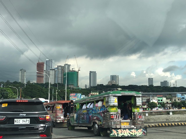
New reclamations at Manila Bay
As our plane approached to land at NAIA yesterday, I saw the current extent of the reclamation projects underway at the Manila Bay.
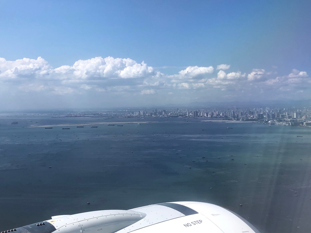


These projects are expensive to implement and will surely lead to even higher real estate prices. This will translate to expensive office, commercial and residential units. So one wonders who will ultimately benefit from these developments. Will government come in and require low cost housing here or will future workers have to commute to these places from the suburbs? The latter will definitely put more pressure on an already deficient transport system.
–
On development density and transportation
The term ‘density’ here does not refer to transport or traffic density in the traffic engineering sense but to density of development such as urban density or building density. Here is an interesting article about building during a climate crisis. While it is very much applicable to any situation, the need to revisit plans and designs has become more urgent with the current pandemic.
Alter, L. (November 19, 2021) “What’s the Right Way to Build in a Climate Crisis?” Tree Hugger, https://www.treehugger.com/what-is-right-way-to-build-in-climate-crisis-5210156 [Last accessed: 2/23/2022]
There are mentions to various references throughout the article so it is not entirely an opinion piece but supported by evidence or studies. There is also a note that the article has been fact-checked. Quoting from the article:
“Adding gentle density can help ensure there are enough people in a neighborhood to support local schools, health, and community services and keep shops and restaurants open. It can provide a range of housing types and tenures that support the needs of individuals and families throughout all stages of life and allow for aging in place. It can also support public transit services, providing residents with efficient and affordable transportation options without relying on private automobiles.”
What do you think is the ‘right’ density for Philippine cities and municipalities?
–
On housing and transportation
I’ve written about how we should not be trying to isolate transportation as if it is singly at fault for the transport and traffic mess many of us are in at present. There are many factors affecting travel behavior including mode choice. Travel distances, travel times and mode choices are not a consequence of transportation system (including infrastructure) alone. Land development and pricing especially those pertaining to housing are critical in how people decide where to live. These are intertwined with transportation and can be quite complex without the proper data or information to help us understand the relationship. That understanding, we are to assume, should lead us to the formulation of policies intended to correct unwanted trends and perhaps encourage more compact developments that are closer to desirable concepts such as the 15-minute city.
Here is an interesting article to enrich the discussion on this topic:
Dion, R. (October 28, 2021) “Coupling Housing and Mobility: A Radical Rethink for Freeways,” Planetizen.com, https://www.planetizen.com/features/115126-coupling-housing-and-mobility-radical-rethink-freeways?utm_source=newswire&utm_medium=email&utm_campaign=news-11012021&mc_cid=85ec2b565f&mc_eid=9ccfe464b1%5BLast accessed: 11/3/2021]
The first thing that came to my mind are residents of northern and southern Metro Manila and the surrounding provinces. Many chose to buy houses there and beyond (i.e., Bulacan, Laguna and Cavite) and yet work or study in Metro Manila CBDs like Makati, Ortigas and BGC. And they do use the tollways (e.g., NLEX, SLEX, CaviTEX, Skyway) to get to their workplaces and schools.
This is also a relevant and timely topic in the Philippines as many cities are already headed for sprawls that will inevitably put more pressure on transportation infrastructure development that usually leans towards car-oriented projects (e.g., road widening, new roads, flyovers, etc.) rather than people-oriented ones (e.g., modern public transportation systems, bikeways, pedestrian infrastructure). Note that only Tokyo has developed an extensive enough railway system to cover the sprawl that is the Tokyo Metropolitan Area, which if interpreted loosely also includes Yokohama, Kawasaki and Chiba in the sprawl. No, we cannot build as fast to have as dense a railway network as Tokyo’s or other cities with similar rail systems. And so we have to figure out another way to address this problem.
–
