
Home » Posts tagged 'maps'
Tag Archives: maps
Metro Manila rail network by 2030?
I saw another map circulating in social media. It would really be nice to have a more comprehensive rail network for Metro Manila or perhaps the Greater Capital Region (Mega Manila or NCR plus or whatever you want to call it). Maps like this give us something to look forward to. We are made to be hopeful about our places being served by trains just like what some of us have experienced abroad in cities like Singapore and Tokyo.

Credits are due to whoever made this map. While it has the DOTr logo, I am not sure someone from there made the map. There are many ‘mapmakers’ out there who can make transit maps like this.
–
Old maps of Rizal Province
I found these two old maps of the Province of Rizal. I was trying to trace their sources but couldn’t find them yet. These were shared from social media pages.
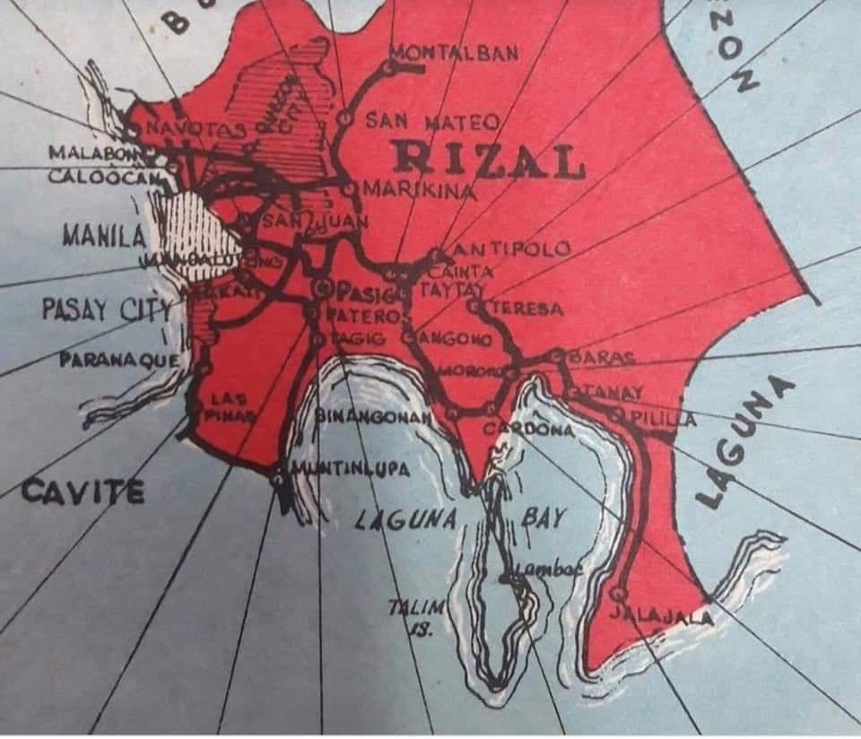
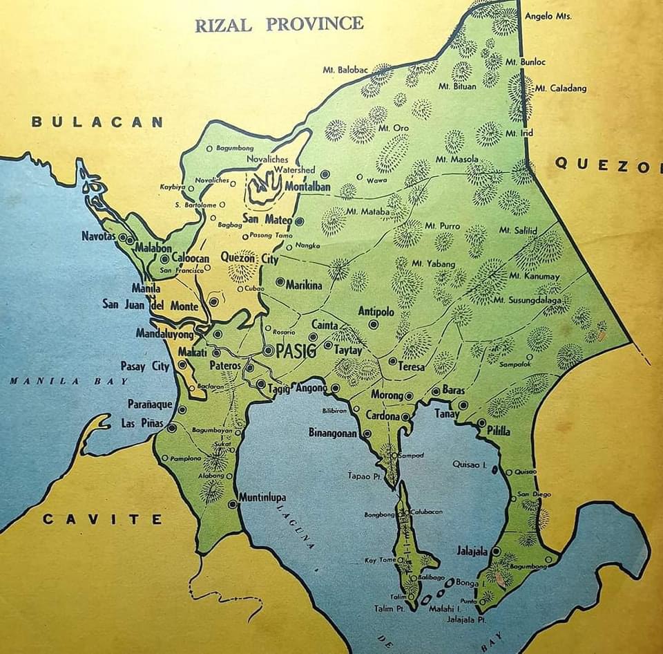
The second map clearly shows the Rizal towns that eventually became part of Metro Manila in the 1970s. These include Navotas, Malabon, Caloocan, Marikina, Pasig, Tagig, Mandaluyong, Makati, Pateros, Paranaque, Las Pinas and Muntinlupa. Pasig used to be the capital of the province; hence, Kapitolyo, which is still in Pasig. Note, too, that Caloocan was connected via a narrow strip between Quezon City and Bulacan. That part of Bulacan is the then town of Valenzuela that was also integrated with Metro Manila. I wrote about a ‘what if’ a while ago where politics would have been different in the province if it remained as it is before the creation of Metro Manila. History teaches us a lot of things including decisions made that led to how we are today. That certainly applies to transportation and definitely applies to politics if you come to think of it particularly for Rizal.
–
On using Google Maps to determine the best route from the pollution perspective
I saw this article on digital maps (i.e., Google Maps) being used to determine the best route for traveling between an origin and destination on land. It is interesting because what we usually use as basis for selecting our routes (assuming we can do so since people taking public transport basically have fewer options due to PUVs having mostly fixed routes) are travel time, travel distance and travel cost. Here is the article discussing the addition of fuel efficiency and emissions to the criteria:
Calma, J. (July 25, 2023) “People are using Google Maps to cut down tailpipe pollution,” The Verge, https://www.theverge.com/2023/7/24/23805652/google-maps-fuel-efficient-routes-transportation-emissions [Last accessed: 7/29/2023]
To quote from the article:
“According to Google’s own analysis, many drivers are taking the path of least pollution in their cars. To calculate the tailpipe emissions that prevented, the company compared how much fuel Maps users likely consumed on the routes they drove to how much fuel they would have burned through had they taken the fastest route without its eco-friendly routing tool. The savings amounted to 1.2 million metric tons of avoided CO2 emissions between October 2021, when Google launched the tool, and December 2022.”
While this seems to be a first foray into the including of eco-friendly items in route choice, these items are already and actually included in many travel planners including those used by people selecting which flights to take. We probably just didn’t notice them before or the information were not explicitly stated or posted. Would this really affect or influence the way we travel like how it is reported in the article? Or do we continue to go with the usual and familiar routes?
–
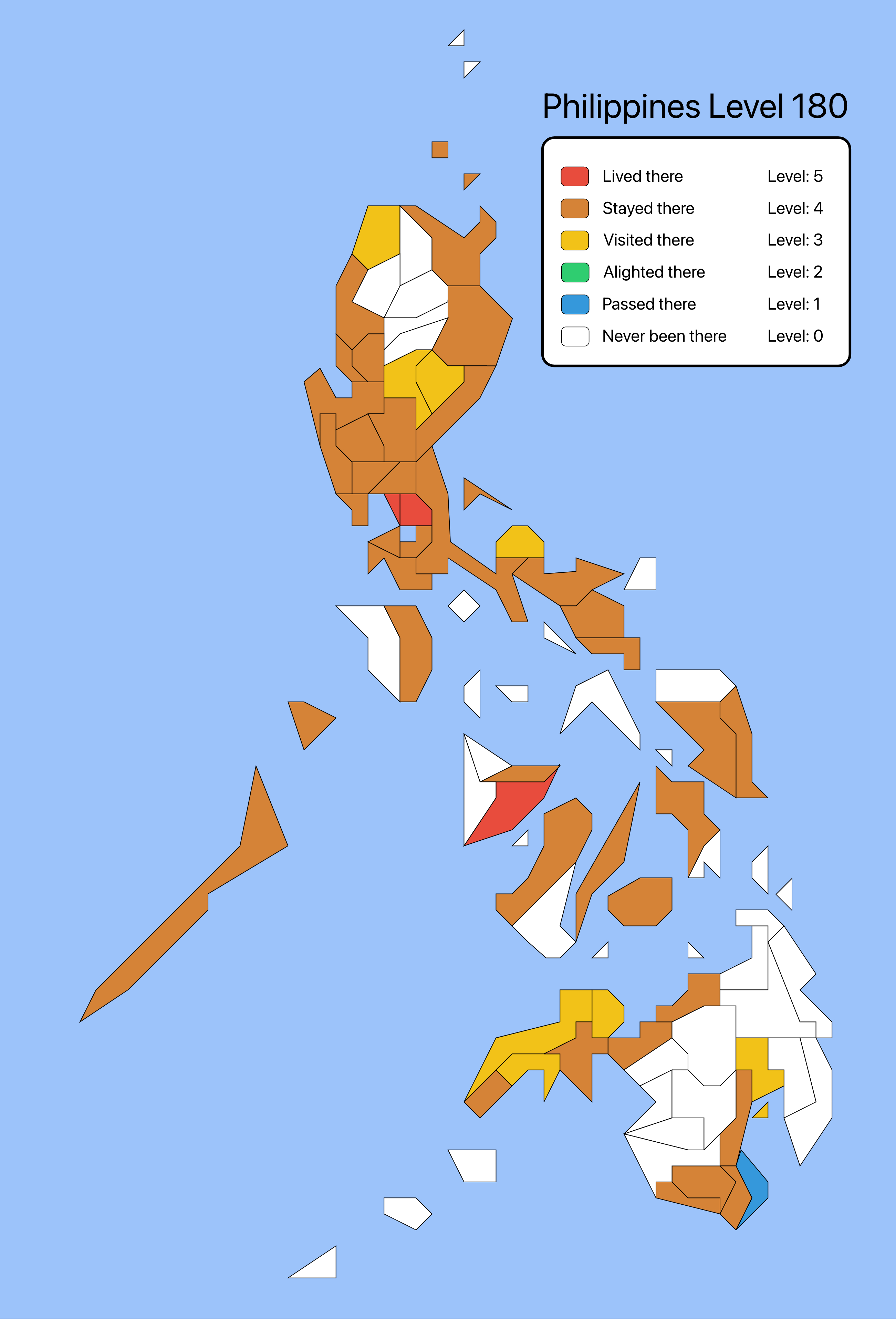
Been there, done that
A map share went viral the past week as people thought about the places they’ve been to. The map showed the provinces in the Philippines (there are other versions featuring maps of other countries like Japan) and you’re to determine whether you’ve lived there, stayed there, visited there, alighted there, passed there, or never been there. I am sharing my map here instead of on social media. My definition of ‘lived there’ is if I actually have a residence in the province. ‘Stayed there’ is if I at least spent the night there. ‘Visited there’ is more an excursion for me including making a stopover to have a meal. ‘Alighted there’ is a bit unusual for me since it should be the same as ‘passed there’. ‘Passed there’ for me is simply going through the province without stopping for a meal, to buy something, to take a few photos or a toilet break.
–
NCR checkpoint map
I just wanted to share the checkpoint map developed by a good friend from UP. Here is the text and link provided by UP Resilience Institute head Mahar Lagmay on his FB page:
Metro Manila quarrantine checkpoint map now available. It is already linked with the Google Traffic Map. Sana makatulong. You can check the traffic status if you zoom in on the interactive map.
Many thanks to Prof. Noriel Christopher Tiglao of UP NCPAG. He is a civil engineer by profession and has conducted research on transportation management and policy with the National Center for Transportation Studies (NCTS).
Copy paste to your web browser this URL http://35.185.190.69/
and continue to accept. Walang pong virus iyan.
I hope this is good info to many!
–
On old maps
I have a fascination for old maps. These include the stylised ones and even those that are considered mythical like the Piri Reis map. Here is something that’s real and old that the map enthusiasts among my readers maybe interested in:
You can download versions of the map though the good ones are quite big and slow to obtain if your internet connection’s not good.
–
Data on local roads – digital maps
Here’s another quick reference to an article describing a current undertaking to map the 45,000+ kilometers Philippine road network:
PH undertaking $5M digital mapping of 45,000-km road network
What’s significant with this development is that soon the country will have excellent maps, including 3D and 360-degree views of most if not all local roads. While there are similar maps via Open Street Maps and Google Maps, the latter are not as comprehensive. These maps will be very useful for a lot of applications including transport planning, urban and regional planning, and disaster mitigation. A lot of people are surely looking forward to the completion of this project as well as when the maps can be accessed and used.
–
