
Home » Posts tagged 'tourism'
Tag Archives: tourism
May-time pilgrimage
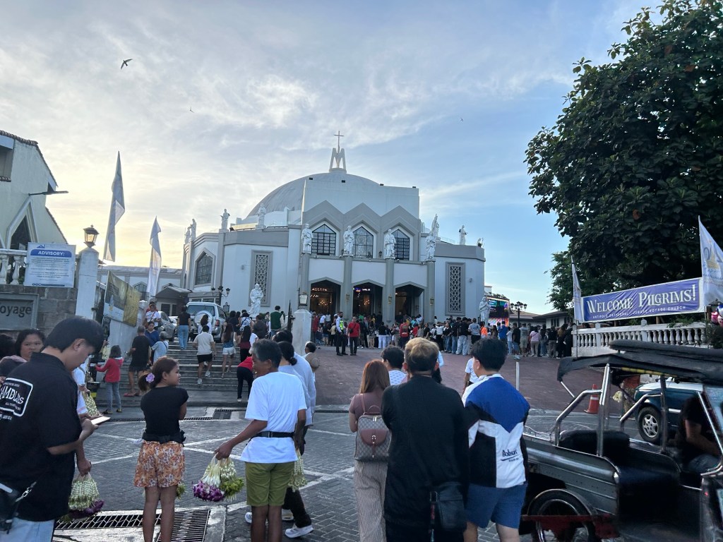
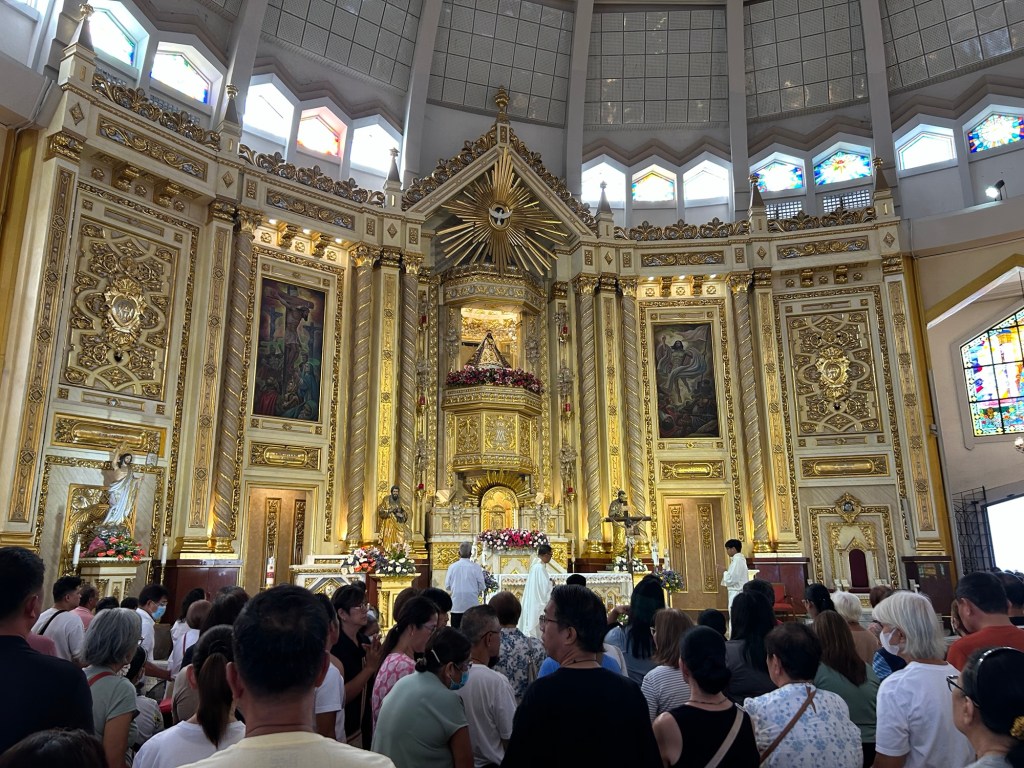
Last April 30-May 1, there was another ‘Alay Lakad’ to the shrine in Antipolo. The pilgrimage walk started in Quiapo Church (Black Nazarene) and ended at the Antipolo church (Our Lady of Peace and Good Voyage). Dubbed the “Walk for Peace,” there usually was a lot of people considering the number of devotees as well as May 1 being perhaps a holiday. Antipolo and Taytay LGUs at least put up stations for assistance to pilgrims.
We started hearing Mass again at the shrine last Sunday as our daughter prefers going there instead of at the chapel at our village. She’s gone to two Lenten Alay Lakads the past two years so maybe she felt this was a kind of pilgrimage for her, too.
For those walking from Metro Manila, there are two general routes to Antipolo. One is via Ortigas Avenue Extension and Tikling junction and the other is via Sumulong Highway and Masinag junction. You can take public transportation from Cubao or Crossing where there are jeepneys and buses. Many terminate at the Robinsons Antipolo mall terminal. But there are many other smaller terminals around the city including some near the Simbahan itself. There are also many tricycles that can take you to the shrine from various points in Antipolo including the Line 2 station at Masinag. Line 2, of course, is a convenient and fast way to get to Antipolo from Manila and Quezon City.
–
Another ‘a bridge too far’?
Earlier this month, I was reminiscing about a trip I made before the pandemic. I was in the Netherlands during one Holy Week to participate in the final defense of a PhD dissertation. I was the external panelist and was invited to be there in person. This was prior to the pandemic and the preference for online participation. I took advantage of the travel to make a side trip to a few locations I previously only watched onscreen. Several bridges there were subject of a World War II film, “A Bridge Too Far.” This was about the bridges the allies attempted to capture during Operation Market Garden. The term “a bridge too far” is now used to refer to the folly of going beyond what can really be achieved. It can also be used to refer to something (including bridges) that one sought to build or create but is just not called for or required.
I wrote in the past about projects that are nice to have but are not necessary or priority. These included bridge projects that are supposed to connect major islands in the Philippines. Given the limited resources we have and the long list of infrastructure projects that need to be prioritized, these shouldn’t be on top of a city’s or province’s list over projects like transit systems, affordable housing closer to workplaces and schools, and schools. And even if we did commit to bridges, it doesn’t make sense to build them where they are likely to cause more damage than benefits. One such bridge that is now in the pipeline and currently making the rounds of social media pages is the proposed bridge connecting Boracay Island to Panay Island. It simply doesn’t make sense to make a tourist attraction like Boracay more accessible to even more people. The island already exceeded its environmental carrying capacity many years ago and more people via this bridge will definitely be disastrous to its ecosystem aside from the social and economic impacts of the bridge.
I googled the land areas of three islands where bridges are proposed for construction. Here are the results:
“Guimaras is the largest of the three at roughly 611.87 square kilometers, followed by the Garden City of Samal at 301.35 square kilometers and Boracay, which is the smallest at only around 10.32 square kilometers. Guimaras is a province, Samal is a component city, and Boracay is a tiny tourism-focused island.”
While it might make sense for such bridges to be built to connect Iloilo with Guimaras and Davao with Samal Island, it doesn’t make sense for Boracay’s case. Guimaras and Samal will be better served by the bridges across many aspects of their being local government units and not just a tourist attraction. Guimaras’ mangoes, for example, can be transported more efficiently to Iloilo where a world class port can transport the fruits in bulk to destinations where they are in demand. The bridge will also ultimately link the island province to Iloilo’s airport. Both Guimaras and Samal have nice beaches and resorts but they are not the only attractions or activities of these islands. Granted that boatmen and maritime transport between the islands will be affected by the bridges, the impacts can probably be alleviated by a shift in their livelihoods (of course, with the assistance of government and partners). The perception is that Guimaras and Samal stand to gain more in terms of benefits while Boracay will deteriorate should it become so easily accessible.
–
Impacts of the energy crisis on tourism – the transport perspective
The Holy Week holidays practically begin this weekend with an expected exodus of people from Metro Manila and its environs (NCR Plus or Mega Manila depending on which term you prefer). Many people take a vacation during the Holy Week. Most probably go for a homecoming. Taking advantage of the holidays to visit their hometowns and have reunions. We did so for most of Holy Weeks past and in my father’s hometown, they take advantage of the homecomings including those of balikbayans from overseas to have a general homecoming at the town’s High School.
Many others in the past decade have their vacations during the Holy Week. The past years saw especially after the pandemic saw people travel abroad to catch spring time in temperate countries like Japan and Korea, even in Europe. Others prefer to travel in the region as Southeast Asian countries provide interesting destinations including the usual Bangkok, Hanoi, Ho Chi Minh, Kuala Lumpur, Jakarta and Singapore. Of course, you can also do local with people flocking to destinations where the beaches are like Bohol, Cebu and Palawan, just to mention some of the choices.
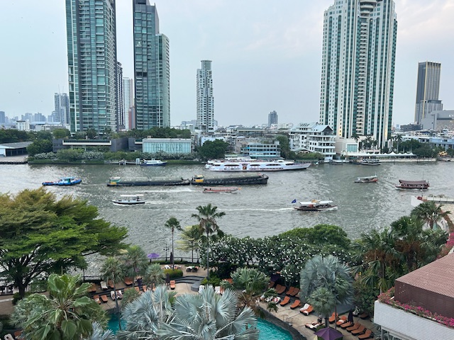 The view from the Shang in Bangkok – we spent the Holy Week there in 2024
Tourism will always involve travel and transportation. The industry will suffer much with the ongoing crisis as fuel prices will eat up a lot of travel budgets as fuel-related expenses will make travel prohibitive to many. On the supply side alone, airlines and maritime companies might have to cancel trips if they cannot sustain fuel supplies. Thus, planes will have to be grounded and ferries/vessels will have to reduce trips to conserve on fuels. That means people cannot travel to tourist destinations and will have to cancel and get refunds (if they can’t reschedule) from their accommodations (hotels, resorts). Less tourists means other businesses suffer, too, including restaurants, cafes and eateries, souvenir shops, and others depended on tourists for incomes. Damay-damay na, as they say.
Let’s hope the crisis will soon be over and this Holy Week, perhaps we can have some reflections and prayers while we take our health and re-energizing breaks.
–
Been there, done that
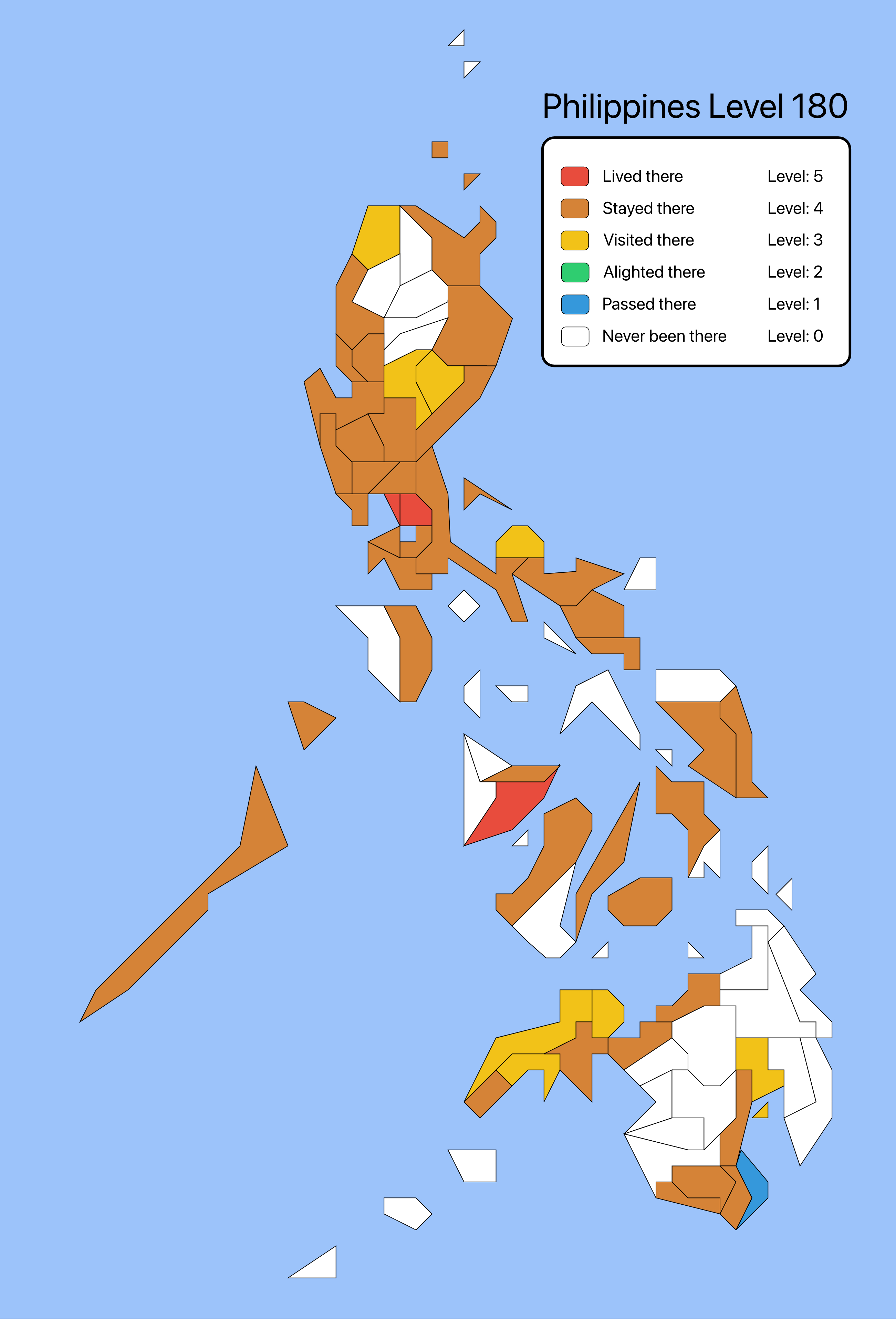
A map share went viral the past week as people thought about the places they’ve been to. The map showed the provinces in the Philippines (there are other versions featuring maps of other countries like Japan) and you’re to determine whether you’ve lived there, stayed there, visited there, alighted there, passed there, or never been there. I am sharing my map here instead of on social media. My definition of ‘lived there’ is if I actually have a residence in the province. ‘Stayed there’ is if I at least spent the night there. ‘Visited there’ is more an excursion for me including making a stopover to have a meal. ‘Alighted there’ is a bit unusual for me since it should be the same as ‘passed there’. ‘Passed there’ for me is simply going through the province without stopping for a meal, to buy something, to take a few photos or a toilet break.
–
Bisikleta Iglesia – Visita Iglesia on a bicycle
I read this post shared by a former student-advisee about a Bisikleta Iglesia being organized in Quezon City. Here are some information I got from the post:
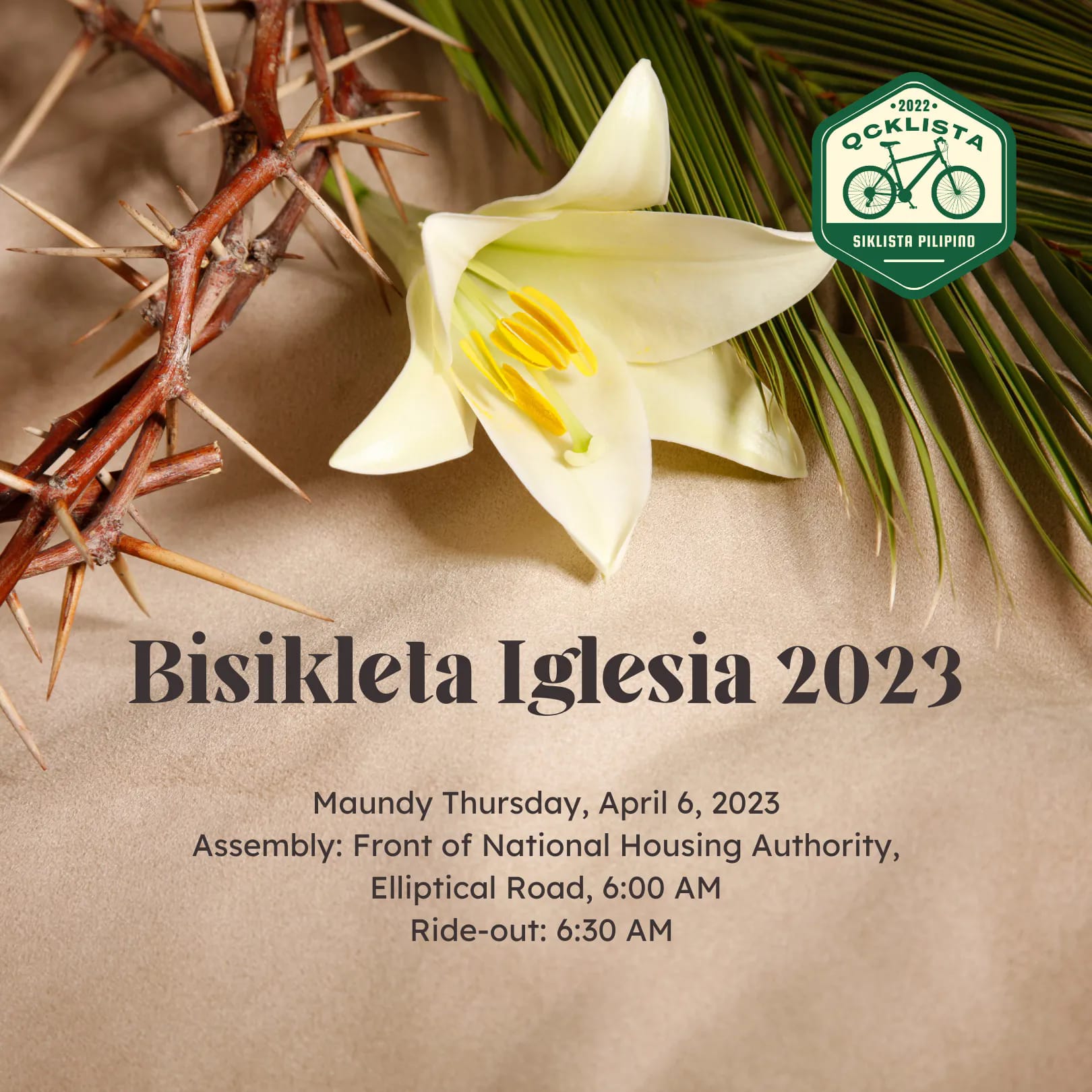


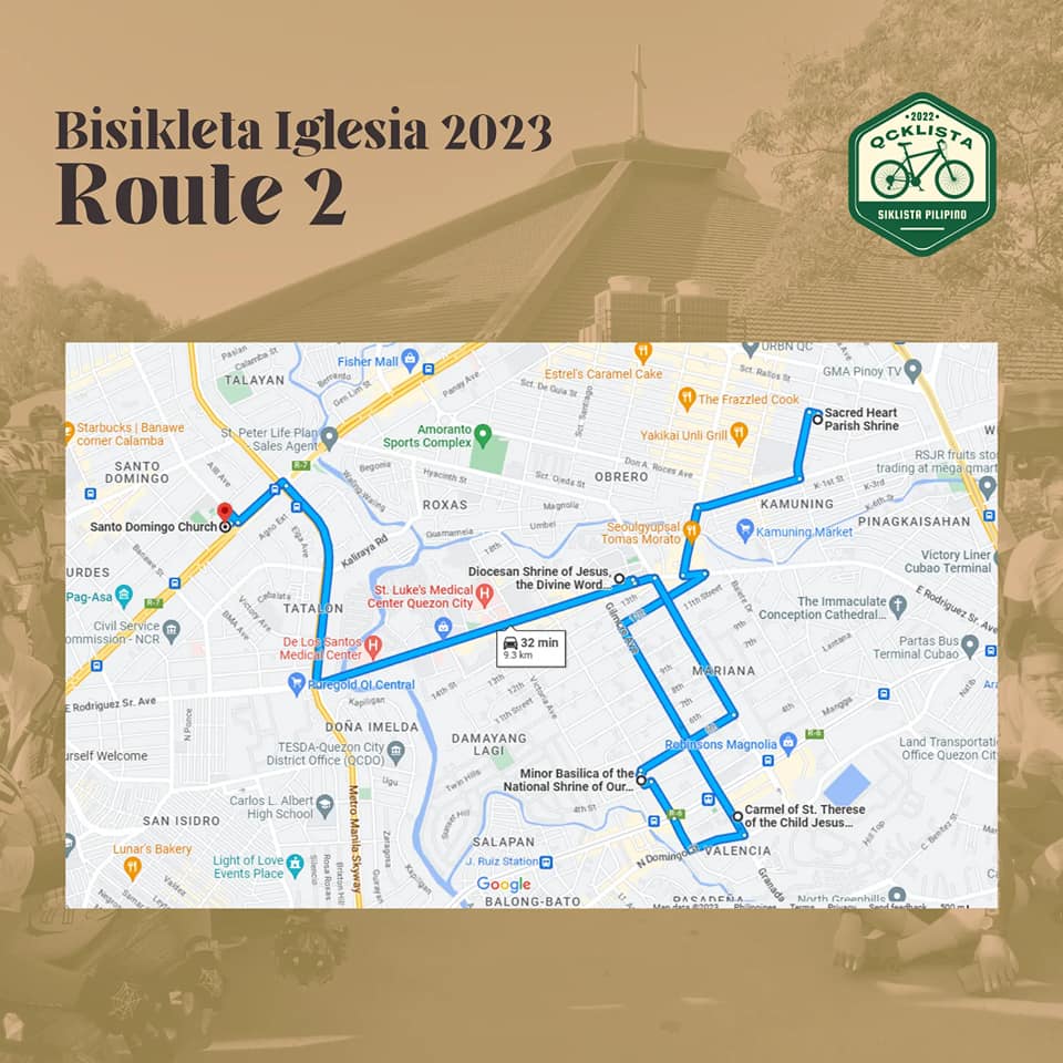
More details on their Facebook page:
https://www.facebook.com/PadyakQCklista
Of course, if you’re more into longer distance rides and even older churches, there are other routes to consider around Metro Manila. Manila alone would have so many churches to include in a Visita Iglesia itinerary such as the Manila Cathedral, San Agustin Church, Binondo Church, Sto. Nino Shrine, Paco Church, San Sebastián, Remedios, St. Jude, San Miguel and Quiapo (Black Nazarene). I will look for other itineraries shared and try to share them here before Holy Thursday. For those who are more adventurous, I share an old post (April 2019) about a bike able itinerary in Rizal:
https://d0ctrine.com/2019/04/16/visits-iglesia-itinerary/
–
Island hopping again
It’s been more than two years since we last traveled by plane and 10 years since our visit to Panglao in Bohol. So its really something we looked forward to considering we now travel with our daughter and there’s a lot to write about on the experiences.

And there’s a lot about transport to write about and share in this blog. There’s a new airport, the nice roads and the journey between Panglao and Balicasag, among others that I will be writing about soon.
Abangan!
Do we still have to practice self restraint in travel?
I took this photo this morning as I was coming home from the market. Ever since Metro Manila, Antipolo and other areas around the NCR transitioned into General Community Quarantine (GCQ) and Modified General Community Quarantine (MGCQ), a lot of people have been going out and taking group rides on motorcycles and bicycles as if there was no pandemic hanging around. I understand that a lot of people have been holed in their homes for quite some time now but these trips seem excessive considering many are cross-town or even inter-provincial trips that are long in terms of distance and times traveled.
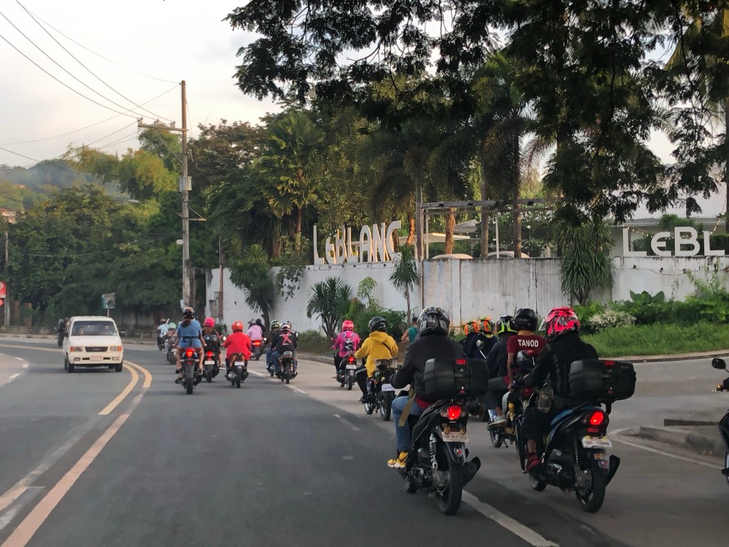
Motorcycle group traveling along Daang Bakal in Antipolo City
I posted the same photo on social media to solicit reactions or comments. I asked the question of whether these trips are necessary. So far, I only got a couple of sad face reactions and a couple of comments. The sad face reactions included one from a cycling advocate. I know the person to be very passionate about bicycle commuting but also advised vs. group rides during MECQ and GCQ. I guess the point here is that we seem to be lowering our guard against Covid-19 and to me these trips (i.e., long rides, group rides) are unnecessary trips. While there seems to be no spikes in infections due to these rides, we don’t know really as data is poorly collected and analyzed. For those who don’t give a damn, I give the analogy of road safety, many situations of reckless driving or riding do not necessarily lead to a crash but the high potential for one means it is something waiting to happen. The same applies to these rides where there might be one, just one, asymptomatic rider who can potentially spread Covid-19. Maybe those infected will be asymptomatic, too. However, others they are in contact with may not be and become seriously ill. So until we do have a vaccine vs. Covid-19 and many are vaccinated already, I would advise against these unnecessary trips.
–
Changi Jewel and transit
The trip to Sri Lanka afforded me some hours at Singapore’s Changi Airport. En route to Colombo, we made sure to go around the complex and check out one of the attractions of the top airport in the world. Changi’s Jewel is very impressive and can make you forgot you were actually inside an airport terminal. Here are some photos taken as we trekked to the Jewel via Terminal 2 and 3.
 Visitors have the option of walking by themselves or using the moving walkway whenever these were available.
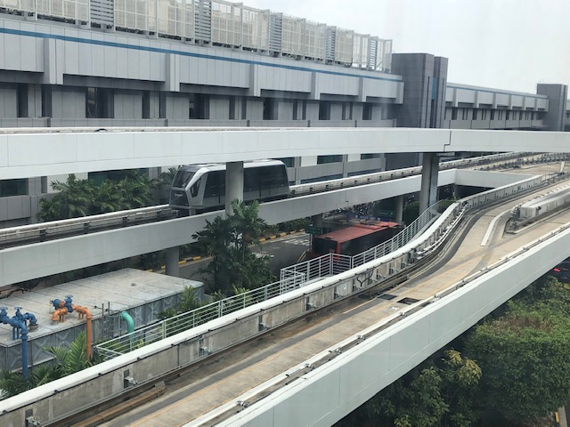
 The automated guideway transit (AGT) system of Changi allow you to transfer from one terminal to another with the exception of Terminal 4.
 I took this photo of the guideway and the AGT as reference for my lectures
 Another view of the corridor connecting Terminal 3 to the Jewel
 Directional sign to the Jewel
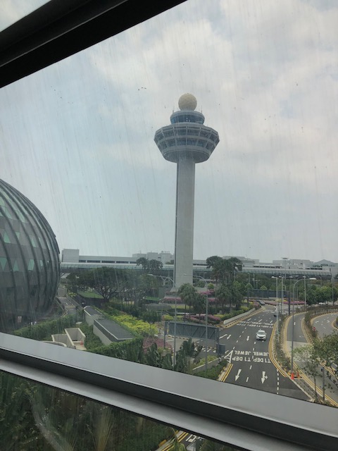 Changi’s air traffic control tower
 The main attraction is this gigantic waterfall located at a man-made complex that’s designed to imitate conditions at a rainforest.
 Changi AGT slow down for passengers to have a good close view of the Jewel
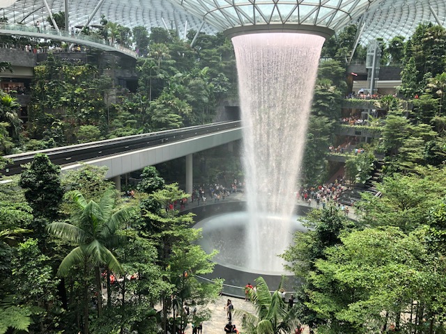 All the water used is recycled and one can get mesmerised by the vortex where all the water falls and seem to be sucked into.
 Here’s another look at the Jewel and the airport AGT
 There is a mall with shops, restaurants and cafes around the Jewel.
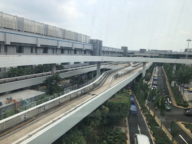 Another photo of the AGT guideway above the road system at Changi
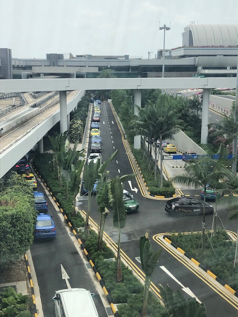 Taxis queued along airport roads
 More guideways
 A look back at the way from the Jewel
More photos of Changi soon!
–
Grab tours?
One of my former students who did research on ridesharing showed me a new feature on the Grab app. There is a vehicle for rent option now in the app as shown in the screen capture below:
 Booking by the hour means you get to set the duration of service. The conventional service is point-to-point (i.e., taxi).
 Choosing “booking by the hour” will lead to a selection of vehicles and the number of hours corresponding to a type of rental.
We showed these to our suking van rental in Cebu and our driver commented that these were expensive. Still, we thought this was a good way to go around the province (not just Cebu City). Of course, such rentals may be more applicable for those who like set pieces when they travel or go on tour. If you’re the more adventurous type, then perhaps you will consider public transportation and walking. It will certainly be less expensive and give a more memorable experience however it goes.
–
The busy Chao Phraya
The Chao Phraya is a very busy river as traffic along this body of water is quite heavy. There are lots of vessels including those used for commuting and tourism. Here are a few photos I took from my hotel room.
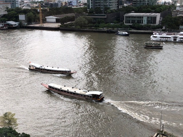 A couple of commuter boats going on opposite directions
 A river cruise vessel that’s popular with tourists. They serve meals on the upper deck and there is entertainment as well as a guided tour of the attractions along the Chao Phraya.
 River traffic is heavy even during night time. Attractions such a the Grand Palace are nicely illuminated at night so these make for impressive sights. Perfect backgrounds while having dinner or perfect subjects if you’re into photography.
 The Chao Phraya Princess (one of many princesses) docking at the Shangri-la
I wonder if the Pasig River can be developed to this level in terms of commuter and tourist traffic.
–
