
Home » Posts tagged 'traffic management' (Page 4)
Tag Archives: traffic management
On Tikling Junction traffic (mis)management
There was an uproar among commuters when Taytay installed traffic signals at the rotunda at Tikling Junction. The junction is the intersection of Ortigas Avenue Extension, which continues towards Antipolo, the Manila East Road, which connects many of Rizal Province’s towns, and Leonard Wood Road, which leads mainly to residential areas in Taytay. There is another road that is close to the junction, Cabrera Road, that qualifies the intersection to be an offset type. However, vehicle coming in and out of Cabrera Road mainly are with respect to the Manila East Road.
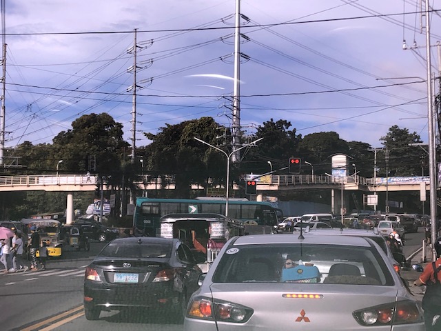
 Traffic signals as seen from the Manila East Road approach to the rotunda
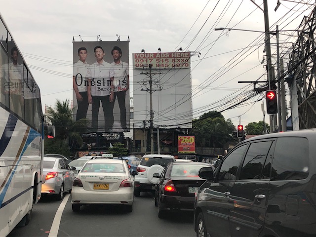
 Traffic signals as seen from the Ortigas Ave. Ext. leg approach from Antipolo
The horrendous congestion last Thursday was due to the settings of the signals that forced most vehicles to stop even though there were movements that were not in direct conflict with others (e.g., through traffic along Ortigas Ave. Ext. from Antipolo towards the direction of Valley Golf/Cainta and right turning traffic from Ortigas Ave. Ext. to Manila East Road). The results were vehicles backed up all the way to Cainta Junction along Ortigas Avenue Extension and SM Taytay along the Manila East Road. We were able to experience the slight congestion the following day (Nov. 1) when we descended to Tikling from Antipolo. Congestion was slight probably because of the significantly reduced traffic due to the holidays.
I thought, based on experiences at this junction, that the traffic signal settings somewhat mimicked the style applied by Taytay traffic enforcers when they manually manage traffic at the intersection. Too often, they apply the “buhos” system where they try to let through all vehicles they see queued per approach. The outcome of this, of course, is longer stopped times to all other vehicles from the other legs resulting in longer and longer queues that become unmanageable especially during the peak hours (i.e., when vehicle arrivals are highest at the intersection). Basically, what happened last October 31 was that the “buhos” traffic enforcers were replaced by the machines (i.e., traffic signals) that employed the same system only this time there was no opportunity for some flexibility for movements that had none or the least conflicts at the intersection.
–
Cooperative work among LGUs to address transport problems along Ortigas Avenue Extension?
I saw a recent post about a meeting hosted by Pasig City. The Mayor of Pasig City recently held a meeting where he invited the mayors or Antipolo, Cainta and Taytay to discuss, among other things perhaps, transportation along Ortigas Avenue. Ortigas Avenue is a corridor shared by several LGUs most notably the Rizal towns of Antipolo (which is the provincial capital and a highly urbanized city), Cainta and Taytay. The latter two are among the richest municipalities in the country; a fact I underline here since that also should translate to them having the resources or means to help come up with transport and traffic solutions.
 Morning rush traffic starts very early these days. This photo was taken around 6AM on a Thursday along the westbound direction just after the Manggahan Bridge. The pedestrian overpass at C. Raymundo junction is shown and the dark colored buildings are at Robinsons’ Bridgetown development. Note the commuters along the right waiting for a ride.
Photos paint a thousand words. The Taytay Mayor attended the meeting. He has been under fire for the horrendous traffic caused by the mismanagement of Tikling Junction as well as the Barkadahan Bridge area that was and is supposed to be a major alternative route for Rizalenos heading to their workplaces in Makati and BGC. More recently, there were posts about the traffic signals installed at Tikling Junction that basically invalidates the roundabout concept for the junction. The result last Thursday, the first day of operations for the signals, was hellish traffic that backed up a couple of kilometers along the Manila East Road and Ortigas Ave. Extension (some reports say until Cainta Junction). This, even as the signal settings were supposedly done with help from the MMDA.
Antipolo was represented by its former Mayor and husband to the current one. He also happens to be a former Governor of the Rizal Province and likely to run again as his mother, the current governor, is on her 3rd term. It seems to me that the province is not so interested in solutions for Ortigas Avenue despite most of its constituents traveling through the corridor to get to their workplaces and schools. Marcos Highway is not the main corridor for Rizal towns as it basically carries only Antipolo and maybe some of Tanay (via Sampaloc) traffic. Ortigas Avenue Extension branches into two major roads from Tikling – Ortigas Ave Extension, which ends at the capitol, and the Manila East Road, which connects to practically all of Rizal towns with San Mateo and Rodriguez (Montalban) being the exceptions. It is time for the province to pay attention to this commuting problem experienced daily by her constituents.
The Mayor of Cainta seems not as interested as the others, sending a representative who appears to be not one of the top officials (the traffic chief with a rank of SPO1=Master Sergeant is lower ranked than a councilor) of the Municipality to such an important meeting. In fact, he is currently now embroiled in a controversial faux pas involving himself by not wearing a helmet while riding a motorcycle. What’s more is his downplaying this and appearing to be even justifying the act. He eventually apologized but not before stating his moves. He is not new to publicity (stunts?) and knows how bad publicity still translates to good publicity especially in this days of fake news and trolls (he apparently has many on social media). He seems to forget that transport and traffic solutions for Ortigas Ave will likely benefit anyone seeking reelection or higher office in Rizal. He is on his last term as mayor and the break-up with some of his allies including his former Vice Mayor who ran against him in the last elections shows the limits of his political career. What was rumored as plans to run for Rizal governor might just be downgraded to perhaps Vice Mayor? In any case, he should show more interest and effort in finding solutions beyond traffic management and not by himself but in cooperation with others with whom his jurisdiction shares the problems with. Perhaps the initiative of the Pasig Mayor presents an opportunity for such cooperative work? Many people are very interested in this and will be watching – and hoping.
–
Is there really a transport or traffic crisis in Metro Manila?
I was interviewed recently for a research project by students enrolled in a journalism class. I was asked by one in the group if we indeed have a transport crisis in Metro Manila. The other quickly added “hindi transport, traffic” (not transport but traffic). And so I replied that both terms are valid but refer to different aspects of the daily travel we call “commuting”. “Traffic” generally refers to the flow of vehicles (and people if we are to be inclusive) while “transport” refers to the modes of travel available to us.
“Commuting” is actually not limited to those taking public transportation. The term refers to all regular travel between two locations. The most common pairs are home – office and home – school. The person traveling may use one or a combination of transport modes for the commute. Walking counts including when it is the only mode used. So if your residence is a building just across from your office then your commute probably would be that short walk crossing the street. In the Philippines, however, like “coke” and “Xerox”, which are brands by the way, we have come to associate “commute” with those taking public transportation.
And so we go back to the question or questions- Do we have a transport and traffic crises? My response was we do have a crisis on both aspects of travel. All indicators state so and it is a wonder many including top government transport officials deny this. Consider the following realities for most commuters at present:
- Longer travel times – what used to be 30-60 minutes one-way commutes have become 60 – 120 (even 180) minute one-way commutes. Many if not most people now have double, even triple, their previous travel times.
- It is more difficult to get a public transport ride – people wait longer to get their rides whether they are in lines at terminals or along the roadside. The latter is worse as you need to compete with others like you wanting to get a ride ahead of others.
- People have to wake up and get out of their homes earlier – it used to be that you can wake up at 6:00AM and be able to get a ride or drive to the workplace or school at 7:00/7:30 AM and get there by 8:00 or 9:00AM. Nowadays, you see a lot of people on the road at 5:30AM (even 4:30AM based on what I’ve seen). That means they are waking up earlier than 6:00 AM and its probably worse for school children who either will be fetched by a service vehicle (e.g., school van or bus) or taken by their parents to their schools before going to the workplaces themselves.
- People get home later at night – just when you think the mornings are bad, afternoons, evening and nighttimes might even be worse. Again, it’s hard to get a ride and when you drive, traffic congestion might be at its worst especially since most people leave at about the same time after 5:00PM. Coding people and others not wanting to spend time on the road (instead working overtime – with or without additional pay) leave for their homes later and arrive even later.
- Less trips for public transport vehicles – traffic congestion leads to this. What used to be 6 roundtrips may now be 4. That affect the bottomline of income for road public transport providers. Given the increased demand and reduced rolling stocks of existing rail lines that includes rail transport.
To be continued…
—
The Barkadahan Bridge situation
The Barkadahan Bridge is currently undergoing rehabilitation. To be accurate, the old bridge is being rehabilitated and upgraded/retrofitted to be able to carry the traffic projected to use it being a vital link between the Province of Rizal and Metro Manila via Pasig and the C-6 corridor. The bridge is named after the “friendship” established among Rizal municipalities and Pasig City for an area that has been subject of a territorial dispute among them. These are the municipalities of Cainta and Taytay (Rizal Province) and the city of Pasig. The bridge spans the Manggahan Floodway, much of which is in Pasig City.
To increase the capacity for this crossing, which is the most direct route to C-6 and popular among many headed to Taguig/BGC and Makati, a new bridge had been constructed to the south of the old one. The older one had 2 traffic lanes and was no longer sufficient for the volume of vehicles crossing it after the expansion of C-6 resulting to it steadily gaining more users over the years. Use of this route cut down travel times between Rizal and BGC and Makati by at least 30 minutes based on our experiences using the route.
Late last year as far as I could recall, the new bridge opened and immediately increased capacity but then congestion quickly set-in due to two factors: the traffic management at the intersection with the East Bank Road and the constrained (two-lane, two-way) leg of Highway 2000. Add to this the lack of discipline by local traffic in the form of tricycles and motorcycles counter-flowing in the area.
Earlier this year, signs were posted around Rizal about the then impending project for the rehabilitation of the old bridge. The signs advised for most travellers to avoid using the Barkadahan Bridge due to the congestion in the area because of the project. It turns out that what was thought by most as a project retrofitting the old bridge alone was actually a bigger one involving increasing the capacity of the Highway 2000 leg of the intersection with the East Bank Road. Following is a photo posted at the official Facebook page of the Rizal Provincial Government showing the demolition of buildings and other structures along the Highway 2000 leg. The photos were taken from the new Barkadahan Bridge approaching the intersection, the southbound direction of the East Bank Road, and from the westbound side of Highway 2000.
 Demolition and clearing of ROW for the expansion of Highway 2000 in relation to Barkadahan Bridge [Photo collage from the Lalawigan ng Rizal Facebook page]
From the photos above, it is clear that at least 2 lanes will be added to Highway 2000 and that this leg will soon be well-aligned with the Barkadahan Bridge, which will also have a total of 4 lanes. Hopefully, this project will be completed soon and within the year (before December?) in order to alleviate the commuting woes of Rizalenos working in the BGC and Makati CBD areas. Of course, that goes without saying that there is also a need to optimise the traffic signals at the intersection and to strictly enforce traffic rules and regulations vs. erring motorists in the area.
–
Alternate route via the Katipunan-Col. Bonny Serrano and C5-FVR Road intersection
I wrote previously about the alternate routes for eastbound vehicles given the ongoing rehabilitation of the Marcos Highway Bridge. In this post, I give some details on one alternative via C-5 and FVR Road (Riverbanks).
 The intersection of Katipunan Ave.-Col. Bonny Serrano Ave. now features a left turn signal for vehicles approaching from Blue Ridge. Previously, this was not allowed and vehicles would have had to go straight or take a right, and then make a U-turn if they wanted to head towards FVR Road. Otherwise, travellers would have to take the tunnel and make the U-turn at Eastwood.
 Vehicles queued along the C5 section approaching the intersection with FVR Road. The overpass in the photo is the section transitioning from the tunnel with an off-ramp past FVR Road.
 Vehicles approaching the now signalised C5-FVR Road intersection. Previously, too, this intersection did not have traffic signals. Vehicles coming down from Blue Ridge/White Plains could not go through to FVR Road but would have had to travel to the U-turn slot not far from here.
 The intersection of C5 and FVR Road – shown are vehicles turning from FVR Road to C5 southbound as well as those turning from C5 northbound to FVR Road.
–
Traffic management schemes for the Marcos Highway bridge rehab
The rehabilitation of the Marcos Highway Bridge in Marikina has necessitated traffic management schemes at the bridge itself and along alternative routes to alleviate congestion in the area. These are collectively called traffic or transport systems management (TSM) schemes with the objective of optimising existing infrastructure and resources without necessarily building something entirely new. These are quite different from travel demand management (TDM) schemes that include number coding and truck ban policies that are already being implemented (though Marikina does not implement the number coding scheme).
 Traffic build-up at the approach to the intersection with FVR Road (To Riverbanks). This is now a signalised intersection as traffic from Blue Ridge/White Plains is now allowed to cross to FVR Road.
 Using the route via FVR Road (Riverbanks) means you don’t have to cross the Marcos Highway Bridge and travellers will merge with those who crossed the bridge just before the Line 2 Santolan Station.
 In the mornings, one lane each is allocated for either the eastbound or westbound traffic. That’s practically a total of 3 lanes (+2 lanes westbound for the SM Marikina Bridge) for the westbound direction and a single lane for the eastbound side. This is logical given the directional distribution of traffic at this time of day and the alternative routes already available to travellers.
Here are a few photos taken on a night time drive. Note that this was taken by a passenger. Don’t even try doing this (taking photos) while driving a vehicle, and especially not while on a motorcycle.
 Entrance to the bridge right after Maj. Dizon – this part is not affected by the rehab works but vehicles position themselves to shift towards the left side, which is the usable part of the bridge.
 Both lanes of the westbound side of the bridge are used for eastbound traffic. Westbound traffic are all along the SM Marikina bridge for a total of 2 lanes each for either direction of flow. The cones are not removed for practicality since they would have to be installed for the morning when one lane is allocated for the westbound traffic.
 Vehicles shift to the right to return to the correct lanes for eastbound traffic along Marcos Highway at the Santolan area. Note the westbound vehicles shifting towards the underpass and SM Marikina on the left.
–
On the traffic flow predicament at Tikling junction…again
During weekends, a constant frustration have been the incidence of severe traffic congestion along Ortigas Avenue Extension. Weekday evenings are usually better in terms of traffic compared to Saturdays. But last Monday, the congestion was so severe the congestion reached Valley Golf and vehicles had to crawl to Tikling. As mentioned in previous posts on this subject, part of the problem is the sheer volume of vehicles that make the roundabout set-up inappropriate for the junction. Then there is also the issue about the people who are supposed to manage traffic but end up mismanaging it. From what I usually observe, they tend to favour vehicles coming from Taytay via the Manila East Road leg and seem oblivious to the build-up of traffic along Ortigas Ave. Ext. eastbound.
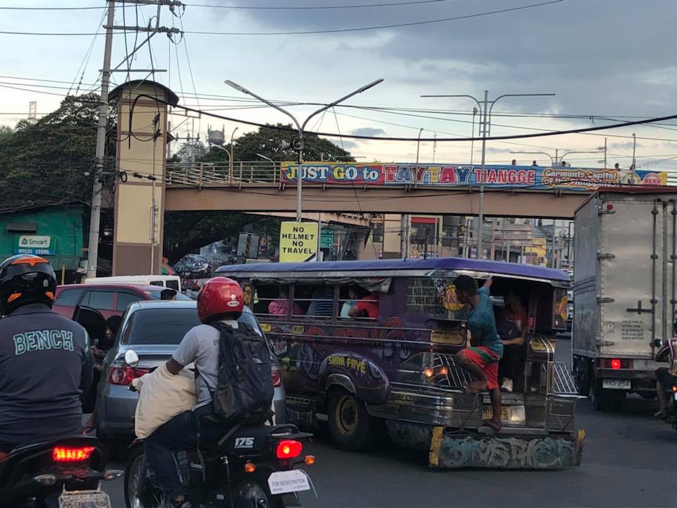 Typical heavy traffic at Tikling Junction
We might finally get a chance to have a solution for this. One of our students took on a topic that will require her to asses the traffic at the intersection to determine, for example, whether the roundabout is suitable or perhaps should be changed into a signalised traffic control. Both analytical approach and microsimulation (using Vissim or the homegrown LocalSim) will be employed. But we will have to wait by May to see some substantial results.
–
On EDSA transport and traffic, again
There’s a recent decision by the Metro Manila Council (MMC) comprised of the mayors of the cities and municipality of Metro Manila and chaired by the Metro Manila Development Authority (MMDA) Chair that vehicles bearing only one passenger (the driver) will be banned from travelling along EDSA. The problem with this is that by banning cars with one passenger from EDSA, you only succeed in making other roads like C5 more congested. It’s a simple case of transferring traffic and worsening it elsewhere since you’re not doing anything to alleviate congestion along those roads. Did MMDA run this and other scenarios using analytical or simulation tools at their disposal? If so, can these be shown and used to explain the soundness of this policy approved by the MMC? I suspect they didn’t and likely depended more on gut feel based on the data they have including what is often reported as 70% of vehicles traveling along EDSA having only one passenger. Meanwhile, the state of mass transit along EDSA still sucks.
 A very crowded Boni Avenue Station platform (photo courtesy of Mr. Raul Vibal)
Of course, the pronouncement from the MMDA launched quite a lot of memes on social media. Some people shared the typical quotes on planning (you know, like the ones about planning for people vs. planning for cars). Some offered their own ideas about how to “solve” traffic along EDSA. And so on…that only succeeded in showing how everyone had an opinion about transport and traffic. Everyone is an expert, so it seems.
Some thoughts and not in any order:
- The government can initially dedicate a lane each for express buses (a la Bus Rapid Transit or BRT). This idea has been circulating for quite some time now and has a good chance of succeeding. The DOTr is already deploying buses that they say are supplementing the MRT 3 trains (i.e., there aren’t enough trains running so passengers have the option of taking a bus instead). Running along the inner lanes of EDSA would mean, however, that they would have to find a way for passengers to cross the road and one idea would be for the stations to be retrofitted for this purpose.
- Those cars along EDSA are not necessarily for short trips so walking and cycling while needing space may have less impact in the immediate term for such a corridor. In the meantime, serious consideration should be made for bike lanes whether on the ground or elevated and improvements to walking spaces.
- But these efforts to improve passenger (and freight) flows should be a network-wide thing and not just along EDSA.
- It’s time to have serious discussions and perhaps simulations (even a dry run) of congestion pricing in Metro Manila. Congestion pricing for all major roads and not just one or two. Funds collected goes to mass transit, walkways and bikeways development. DOTr was supposed to have already discussed an Electronic Road Pricing (ERP) system like Singapore’s with the company and people behind the same in the city-state. That doesn’t seem to be moving along.
- Working and studying from home might work in terms of reducing vehicular traffic but then we generally have lousy internet services so that’s a barrier that needs to be broken down.
- How about legalizing, once and for all, motorcycle taxis? Many are opposed to this citing safety concerns but then we are running out of options outside the usual motherhood statements pertaining to building transport infrastructure. Think about it. Give it a chance. These motorcycles might just surprise us in a nice way; that is, helping alleviate congestion.
- Carpooling and lanes dedicated to High Occupancy Vehicles (HOV) would be good but the LTFRB made a pronouncement about these being illegal as they would be considered ‘colorum’. Such statements do not make the situation any easier and sends mixed signals as to the government’s being serious in considering all possible angles to improve transport and traffic particularly for commuting.
Do you have other ideas to share?
–
On the opposition to “complete streets”
I recently read an article about the opposition to road diets in California, USA:
Tinoco, M. (2018) “How to Kill a Bike Lane”, http://www.citylab.com, https://www.citylab.com/transportation/2018/05/how-to-kill-a-bike-lane/559934/?utm_source=SFTwitter [Last accessed: 5/20/2018]
So far, we know that at least three cities are progressive enough to implement road diets including Marikina City, Pasig City and Quezon City. Iloilo doesn’t count yet since their bike lane was constructed along the very wide Diversion Road. Our recommendations for Tacloban, if implemented by the city, will probably result in the second most comprehensive application of road diets/complete streets in the Philippines after Marikina, which implemented their bikeways network almost 2 decades ago. There are sure to be many who would be opposed to such schemes as many still have the view that streets are for motor vehicles. This car-oriented thinking is something that will be a challenge to advocates of people-oriented transportation systems. Hopefully, many can learn from experiences here and abroad on how to reclaim space for people leading to safer and more inclusive transport for all.
–
On the Pasig HOV traffic experiment
Someone shared a post about a traffic scheme they will be implementing along Julia Vargas Avenue in Pasig City. The proposal is for the avenue to have a high occupancy vehicle (HOV) lane where vehicles with 4 or more occupants are to take one lane and all other vehicles the other. I am not entirely sure about the objective other than to promote high occupancies for vehicles. However, it would be nice to see how travellers will be behaving (e.g., complying) and how Pasig (with MMDA?) will be enforcing this scheme.
This is what a segment of Julia Vargas currently looks like with 2 wide lanes designated for motor vehicles (separated by the solid yellow line) and one narrow lane for cyclists (adjacent to the shoulder):
The intent is good but as a major link the scheme can be quite confusing especially for those who are not necessarily frequent users of this road. I assumed the yellow line was painted by the DPWH but it seems it was by Pasig. Perhaps they should have removed the old markings? Or maybe better if they rationalised the carriageway width to accommodate 3 lanes for motor vehicles and 1 wider lane for bicycles? From the photo above, it appears to me that it is possible to have 2 narrow lanes for general traffic and one wider lane for HOVs (in this case defined as having 4 or more occupants) and public utility vehicles. This configuration maximises the capacity of the road while having a the “best” lanes allocated for HOVs and bicycles.
I wish them success on this social experiment. Perhaps there can be valuable learnings from this including the need for connectivity to other links as well.
–
