
Home » Posts tagged 'transportation planning' (Page 2)
Tag Archives: transportation planning
Article on “Fair Share Transportation Planning”
I am sharing this new article from Todd Litman on fair share transportation planning. The content is relevant and very timely in the Philippines considering many people including and especially transport officials are struggling with the thought of allocating resources to provide or improve facilities geared towards more equitable transport systems (e.g., more facilities for active transport).
Here’s the summary as quoted from the article:
“To be efficient and equitable, a transportation system must serve diverse demands. A diverse transportation system allows travelers to use the most efficient option for each trip—safe walking and bicycling for local errands, efficient public transit when traveling on busy travel corridors, and automobiles when they are truly the most cost-effective mode considering all impact—and it ensures that people who cannot, should not, or prefer not to drive receive their fair share of public investments.
Current transportation planning practices are biased in various ways that overinvest in automobile infrastructure and underinvest in more affordable, inclusive, and efficient modes. It is time for planners to reconsider our analysis methods and funding practices to ensure that non-auto modes, and therefore non-drivers, receive their fair share of transportation resources.
This is not anti-car. Motorists have good reasons to support more investments in non-auto modes that reduce their traffic and parking congestion, reduce their chauffeuring burdens and crash risk, and provide better options when their vehicles are unavailable. Everybody wins from a more diverse and efficient transportation system.”
On bicycles as a preferred mode of transport
Sharing this article on bicycles being the perfect mode of transportation. It is framed with respect to the concept of the 15-minute city. Here is the article:
Johnson, R. (April 19, 2023) “Embracing the 15-Minute City: 7 Reasons why Bicycles Are the Perfect Mode of Transportation,” Momentum Mag, https://momentummag.com/embracing-the-15-minute-city-7-reasons-why-bicycles-are-the-perfect-mode-of-transportation/ [Last accessed: 4/29/2023]
To quote from the article:
“Bicycles are aligned with the goals of sustainability and climate action, as they contribute to reducing greenhouse gas emissions, air pollution, and congestion. In a 15-Minute City, where the focus is on creating sustainable and climate-friendly communities, bicycles can be a powerful tool to achieve these objectives. By promoting cycling as a viable transportation option, cities can reduce their carbon footprint, mitigate climate change impacts, and promote a greener and healthier way of living.”
–
Video games for aspiring planners?
I saw this article on what are supposed to be the best video games for would-be or aspiring planners. To put this into the proper context, these are mostly newer games (or so I think considering certain games evolve over the years from the time they were first released).
Smith, A.N. (December 23, 2022) “These are the best video games for wannabe urban planners,” Bloomberg CityLab, https://www.bloomberg.com/news/articles/2022-12-23/these-are-the-best-city-builder-video-games-of-2022
When I was younger, the games to play were SimCity and Civilization. These have also evolved, and I think SimCity and Cities: Skylines (a game introduced to me by one of my students) might be the better ones for aspiring planners. You can test many concepts on these games such as transit oriented development (TOD), compact cities, etc. Of course, one can also play with actual planning and simulation software. If one has access to the transport model for Metro Manila, for example, you can test scenarios on this to see how the model will ‘react’ to various conditions or situations.
–
On reducing driving and its inherent risks
Ever since the automobile was invented and eventually mass-produced, there has been an increasing risk associated with motor vehicle traffic. Laws, policies and regulations have also been influenced to favor the car rather than people. And so we now have what is termed as a car-oriented and dependent transportation system that seems so difficult to undo as most people appear to be enamored by the car. Owning a car (or even a motorcycle if you want to extend this idea of individual ownership) remains an aspiration to a lot of people.
Here is a link to the compact version of a comprehensive report by Todd Litman that presents and argues for a new paradigm where driving is considered a risk factor. There are data and a table comparing old and new traffic paradigms to help us understand the situation and what needs to be redefined or re-framed in order to achieve our safety targets or vision.
Litman, T. (October 20, 2022) “Driving as a Risk Factor: A New Paradigm,” Planetizen, https://www.planetizen.com/blogs/119287-driving-risk-factor-new-paradigm?utm_source=newswire&utm_medium=email&utm_campaign=news-10202022&mc_cid=beacdc2a04&mc_eid=9ccfe464b1 [Last accessed: 10/28/2022]
To quote from the article:
“Safer vehicles, roads, and driving may reduce crashes but achieve few other goals, and sometimes contradict them. Transportation demand management and smart growth policies increase safety in addition to helping to achieve other planning goals, and so can be considered win-win solutions.
More comprehensive safety analysis tends to support social equity goals. Many conventional safety strategies, such as larger vehicles with more passenger protection, and wider roads with fewer intersections, tend to increase walking and bicycling risks. In contrast, lower traffic speeds, TDM, and Smart Growth tend to improve safety, mobility, and accessibility for people who cannot, should not, or prefer not to drive.”
The key takeaway here should be that people should have the option of not driving at all in order to reduce the risks associated with driving as well as reduce congestion. A more comprehensive
–
Who can design bikeways?
I have read many comments about how bike lanes and other bike facilities are sub-standard or unacceptable because they were designed by non-cyclists. From an academic perspective and perhaps also from a point of view of someone who values empathy, the planning and design of bicycle facilities should not be so limited. The objective of education, and particularly for schools whose graduates become professionals like engineers, architects and planners, should be to have the latter be able to plan and design the most suitable infrastructure and facilities for all users. Suitability here should include equity considering the many elements involved for people of different gender, physical ability or disability, age, health conditions, etc. That said, it is the responsibility of agencies such as the Department of Public Works and Highways (DPWH) to revise and update their design manuals and guidelines to ensure that these are according to International standards and mindful of the best practices in various cities and countries that are now very well documented.
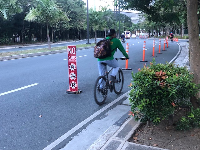 Bike lane in BGC,Taguig City
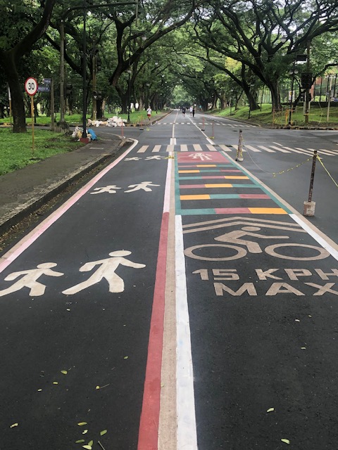 Bike lane and jogging/walking lane in UP Diliman
–
On making streets safer through woonerfs
One of the new things I learned when I was taking up transportation planning as an undergraduate student in the 1990s was about the woonerf. Our teacher then was a Visiting Professor from the Tokyo Institute of Technology. He introduced to us many concepts in that elective course that paved the way to a number of us proceeding to specialize in transportation. What is a woonerf? Well, here’s a nice article defining the woonerf and providing some examples:
Ionescu, D. (October 6, 2022) “What is a Woonerf?” Planetizen, https://www.planetizen.com/definition/woonerf?utm_source=newswire&utm_medium=email&utm_campaign=news-10062022&mc_cid=9d60b3d668&mc_eid=9ccfe464b1 [Last accessed: 10/10/2022]
To quote from the article:
“Translated as “living street,” a woonerf employs strategies like traffic calming devices and low speed limits to force drivers to slow down and safely share street space with pedestrians, cylists, and others, often without raised curbs separating cars and pedestrians. In the Netherlands, where the woonerf originated in the 1960s, motorized traffic within woonerf zones is limited to walking speed…
…A woonerf is not a pedestrianized street, but rather one where multiple users and vehicles co-exist. However, a woonerf can be converted to car-free uses using bollards or other barriers. The woonerf maintains utilitarian uses like loading docks and parking while making the roadway safer and more accessible to non-drivers.”
There should be many applications to the woonerf in the Philippines especially in areas where the dominant land use is residential and through traffic should be discouraged. This is goes well with the complete streets concept that is now being promoted and in fact pre-dates the concept and was well ahead of its time.
–
On transit oriented development issues
I share this interesting article about some issues encountered in the US that affects transit operations and what planners term as transit-oriented development (TOD). While TOD remains a good concept and has been implemented successfully elsewhere (e.g., Japan, Korea, Singapore, European countries, etc.), the experience in the US may be quite different and even contrary. This underlines the importance of proper context when reading these articles that are likely written for an American audience (its published in a major US newspaper).
Sperance, C. (September 14, 2022) “Could it be the end of the line for transit-based development,” The Boston Globe, https://www.bostonglobe.com/2022/09/14/real-estate/could-it-be-end-line-transit-based-development/ [Last accessed: 9/24/2022]
The article describes how TOD came to be in the US:
“Even on a good day, when trains don’t derail or catch on fire, people move away anyway, looking for more space and the luxury of having their own car. But not everyone has the luxury to work from their living room in the burbs. The life sciences building boom in the area requires in-person work.
“We have a very strong economic engine that settled into places where people have to go to work, such as our academic institutions, our hospitals, and our labs,” Dimino said.
That’s a catalyst for transit-oriented development…”
The above quote looks to be very similar to what we have and are experiencing in many Philippine cities as well. I have mentioned and wrote about how housing affordability affects location choices in the Philippines. These choices of where to live ultimately affects transport mode choice and puts pressure on government to provide public transportation to connect suburbs to CBDs (i.e., residential areas to workplaces and even schools). We seem to be following the American model here and it does not help that the prices of residential units in the CBDs (and closer to workplaces) are not affordable to most people. The latter end up purchasing houses away from Metro Manila and in the adjacent provinces or Bulacan, Rizal, Laguna and Cavite. But it takes two to tango, as they say, and mass transit systems (their availability) also contributes to decisions of where to live. I conclude this post with another quote from the Boston Globe article:
“Transit will need to be an anchor and cornerstone of our future regarding equity, the economy, and climate and, therefore, will still be something that will have a relationship to housing decisions.”
–
On phasing out cars in cities
I’m sharing another article on reducing car dependence. The article was referred to by the previous series that I shared recently.
Nicholas, K. (April 14, 2022) “12 best ways to get cars out of cities – ranked by new research,” The Conversation, https://theconversation.com/12-best-ways-to-get-cars-out-of-cities-ranked-by-new-research-180642 [Last accessed: 5/20/2022]
Here are a few excerpts from the article:
“Question: what do the following statistics have in common?
The second-largest (and growing) source of climate pollution in Europe.
The leading killer of children in both the US and Europe.
A principal cause of stress-inducing noise pollution and life-shortening air pollution in European cities.
A leading driver of the widening gap between rich and poor urban residents.Answer: the vehicles on our streets, primarily the not-so-humble passenger car.”
also this:
“The research is clear: to improve health outcomes, meet climate targets and create more liveable cities, reducing car use should be an urgent priority.”
and this:
“To meet the planet’s health and climate goals, city governments need to make the necessary transitions for sustainable mobility by, first, avoiding the need for mobility (see Paris’s 15-minute city); second, shifting remaining mobility needs from cars to active and public transport wherever possible; and finally, improving the cars that remain to be zero-emission.”
You can also listen instead of reading it as it is a narrated article.
–
Articles on examining the role of the planning profession in both perpetuating and solving traffic congestion
Planetizen recently published a three-part series of articles examining the role of the planning profession in both perpetuating and solving traffic congestion:
Part 1: Brasuell, J. (April 13, 2022) “Planning and the Complicated Causes and Effects of Congestion,” Planetizen, https://www.planetizen.com/features/116834-planning-and-complicated-causes-and-effects-congestion [Last accessed: 5/17/2022]
Part 2: Brasuell, J. (April 20, 2022) “How Planning Fails to Solve Congestion,” Planetizen, https://www.planetizen.com/features/116914-how-planning-fails-solve-congestion%5BLast accessed: 5/17/2022]
Part 3: Brasuell, J. (May 12, 2022) “Planning for Congestion Relief,” Planetizen, https://www.planetizen.com/features/117153-planning-congestion-relief?utm_source=newswire&utm_medium=email&utm_campaign=news-05162022&mc_cid=34b0612d40&mc_eid=9ccfe464b1 [Last accessed: 5/17/2022]
I think these articles are a must read especially for students (and not just practitioners or professionals) and is sort of a crash course on transportation engineering and planning. It covers many concepts and learnings from so many decades and touches on certain programs that are most effective in reducing car trips. To quote from the article, the top 12 programs based on case studies in Europe are:
- Congestion Pricing (12-33% reduction in city-center cars)
- Parking and Traffic Controls (11-19% reduction in city-center cars)
- Limited Traffic Zones (10-20% reduction in city-center cars)
- Workplace Mobility Services (37% drop in car commuters)
- Workplace Parking Charges (8-25% reduction in car commuters)
- Workplace Travel Planning (3-18% drop in car use by commuters)
- University Travel Planning (7-27% reduction in car use by university commuters)
- University Mobility Services (24% drop in students commuting by car)
- Car Sharing (12-15 private cars replaced by each shared car)
- School Travel Planning (5-11% reduction in car use for school trips)
- Personalized Travel Planning (6-12% drop in car use share among residents)
- App-Based Incentives (73% – proportion of app users declaring reduced car use)
Are we ready to confront congestion and at the least start discussing these car trip reduction programs? Or are we content with the current discourse, which remains car-centric?
–
Article on evaluating transport equity
Here is another quick share of an article on transportation equity:
Litman, T. (February 2, 2022) “Evaluating Transportation Equity: ITE Quickbite,” Planetizen, https://www.planetizen.com/news/2022/02/116058-evaluating-transportation-equity-ite-quickbite [Last accessed: 2/4/2022]
Transportation equity is a very relevant, very timely topic as people in the Philippines are just beginning to understand and weigh the advantages of having more efficient transport in the forms of active and public transport over private vehicles.
–
