
Undas traffic
Metro Manila traffic is usually lighter during Undas – the days when we remember those who passed away. Many people go back to their hometowns and this is significant because many residing or working or studying in Metro Manila hail from other provinces. Of course, some people would rather go on a vacation during this time with many now opting to travel abroad rather than braving crowded cemeteries of their hometowns. Some do the so-called ‘staycations’ – basically staying put at home during the undas break (Sorry, staying in a hotel is technically not a ‘staycation’ as many people claim it to be.)
What are the facilities that are expected to be congested? These would be the gateways from Metro Manila to other provinces. These would be airports, sea ports, bus terminals and major roads connecting Metro Manila to the provinces. There would be similar situations in other gateways as well such as in Cebu in the Visayas and Davao in Mindanao. Of course, all roads leading to cemeteries, memorial parks and columbariums. These roads would be filled with people (mostly walking) and vehicles (mostly private cars and tricycles and pedicabs if local roads) who congregate in these areas to remember and pay tribute to their dead.
The congestion experienced in most roads during this time of year is usually manageable and local governments can and are usually prepared to address transport and traffic issues within their jurisdictions. Tollways also employ their own strategies and tactics to deal with toll plaza congestion. The Land Transport Franchising and Regulatory Board (LTFRB) issues additional temporary permits to bus companies to field more vehicles along high demand routes. Meanwhile, airports and seaports would have to deal with their own versions of congestion though it is expected that such peaking or spiking up of travel activity can be handled by many airports and ports considering that these facilities are supposed to be designed for higher than usual demands.
Here’s wishing everyone safe travels during this Undas weekend. Mag-iingat lalo na sa pagmamaneho. Huwag magpatakbo na tila hinahabol ninyo ang araw ng mga patay!”
Trip cutting with respect to the LRT Line 2
Trip cutting is one of the undesirable behaviors of public utility vehicle drivers. It is most common with jeepneys and UV Express than with buses.
The findings of the study completed by our students last June 2015 are the following:
- It was proven that trip-cutting behavior is a common practice by both jeepney and UV Express drivers with routes along Marcos Highway and Aurora Boulevard, covering parts of Pasig City, Marikina City and Quezon City.
- The underlying factors involving trip-cutting behavior by PUV drivers were found to be the following:
- Jeepneys and UV Express unload most of their passengrs during peak hours at the LRT Santolan and Katipunan Stations – there was a higher likelihood for passengers to ride the Line 2 from these stations to their destinations including Cubao and the University belt. A lot of passengers are students and trying to keep their schedules. Road transport can be very unpredictable and the trains offer more reliable travel times.
- Drivers can maximize profit by having shorter trips and at the same time having passengers at full capacity – jeepney and UV express drivers unloading most of their passengers at the stations and turning around there (i.e., cutting their trips) means they avoid the congestion along Aurora Boulevard and faster turnarounds translate to their being able to carry more passengers thereby earning more revenues.
- It was observed that the top trip-cutting routes for PUVs along Marcos Highway and Aurora Boulevard are as follows:
- For jeepney vehicles:
- Cogeo – Cubao and Antipolo – Cubao routes in relation to the LRT Santolan Station;
- Calumpang – Cubao and SSS Village – Cubao routes in relation to the LRT Katipunan Station.
- For UV Express vehicles:
- SSS Village – Cubao and Cogeo – Cubao routes in relation to the LRT Santolan Station;
- Marikina – Cubao and Rodriguez/Montalban – Cubao routes in relation to the LRT Katipunan Station.
- For jeepney vehicles:
The following recommendations were made in relation to the findings of the study:
- Route modification of top trip-cutting routes to take into account the realities with respect to the current demand.
- Study on supply of PUVs with respect to the Cubao terminal station in relation to trip-cutting violations.
- In the future, when the construction of the LRT Line 2’s Masinag and Emerald stations is completed, it is recommend to that further route modifications be made relative to these new stations.
Such studies are important especially in light of the construction of railway lines including this case of the extension of Line 2 from Santolan, Pasig to Masinag, Antipolo. There is an opportunity here for the rationalization of jeepney routes to complement the obviously higher capacity and more efficient trains of Line 2. Rationalization here translates to the shortening of jeepney routes with many units terminating at Line 2 stations. ‘Cogeo-Cubao’ jeepneys would become Cogeo-Masinag jeepneys while ‘Antipolo-Cubao’ jeepneys will become either ‘Antipolo-Masinag’ or ‘Antipolo-Emerald’ jeepneys. A Masinag route end would apply to ‘Antipolo-Cubao via Sumulong Highway’ jeepneys while the Emerald route end would apply to ‘Antipoli-Cubao via Junction’ PUJs. Such will reduce the travel distances covered by the jeepneys as well as reduce their travel and turnaround times. Also, such a rationalization will lead to a better structured public transport system following a hierarchy among modes.
–
Improving road drainage to prevent flooding
Road drainage seems to be a most suitable topic given the heavy rains the past few days due to a powerful typhoon that hit the northern Philippines. With or without typhoons, however, the frequency of flash flooding has increased the past few years in part due to the heavier than usual monsoon rains but mainly due to the poor state of road drainage in our cities. The photos below show an example of flash flooding due to a sudden downpour in Cebu City.

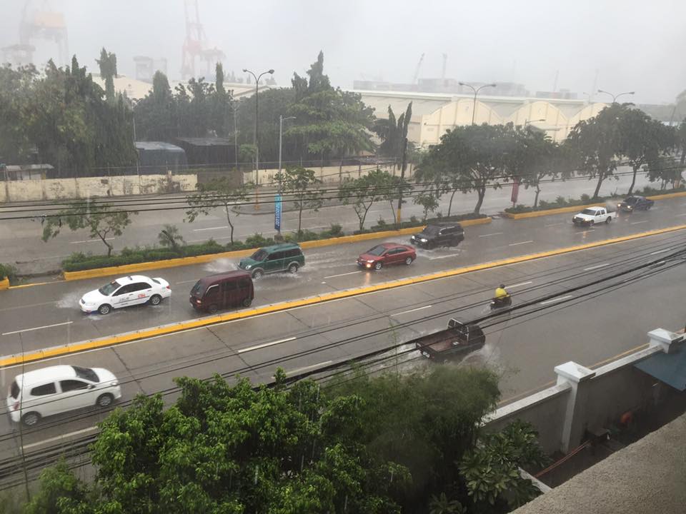
What is noticeable along the road is a lack of storm drains that could have prevented the accumulation of water on the carriageway. If there were storm drains at strategic points along the road, it is difficult to judge from the photo. I also suspect that road construction may have adversely affected the slopes required for the water to travel to the drains. These are surely stated in the road design but are somehow lost or deficient upon construction of the road. There are similar situations in other cities as well and especially in Metro Manila where flash floods often cripple road traffic around the metropolis as critical sections of major arterials like EDSA, C-5, Espana Blvd. and E. Rodriguez become flooded.
We were traveling back to Quezon City along Sumulong Highway after a meeting in Antipolo City. We noticed the road widening projects along the highway; effectively increasing the number of lanes and the capacity of the road. Included in the project are the construction of sidewalks and drainage along both sides of the road. Below is a photo of the section near the Sumulong gate of Valley Golf clearly showing the newly constructed lane and sidewalk along the Masinag-bound side of the highway.
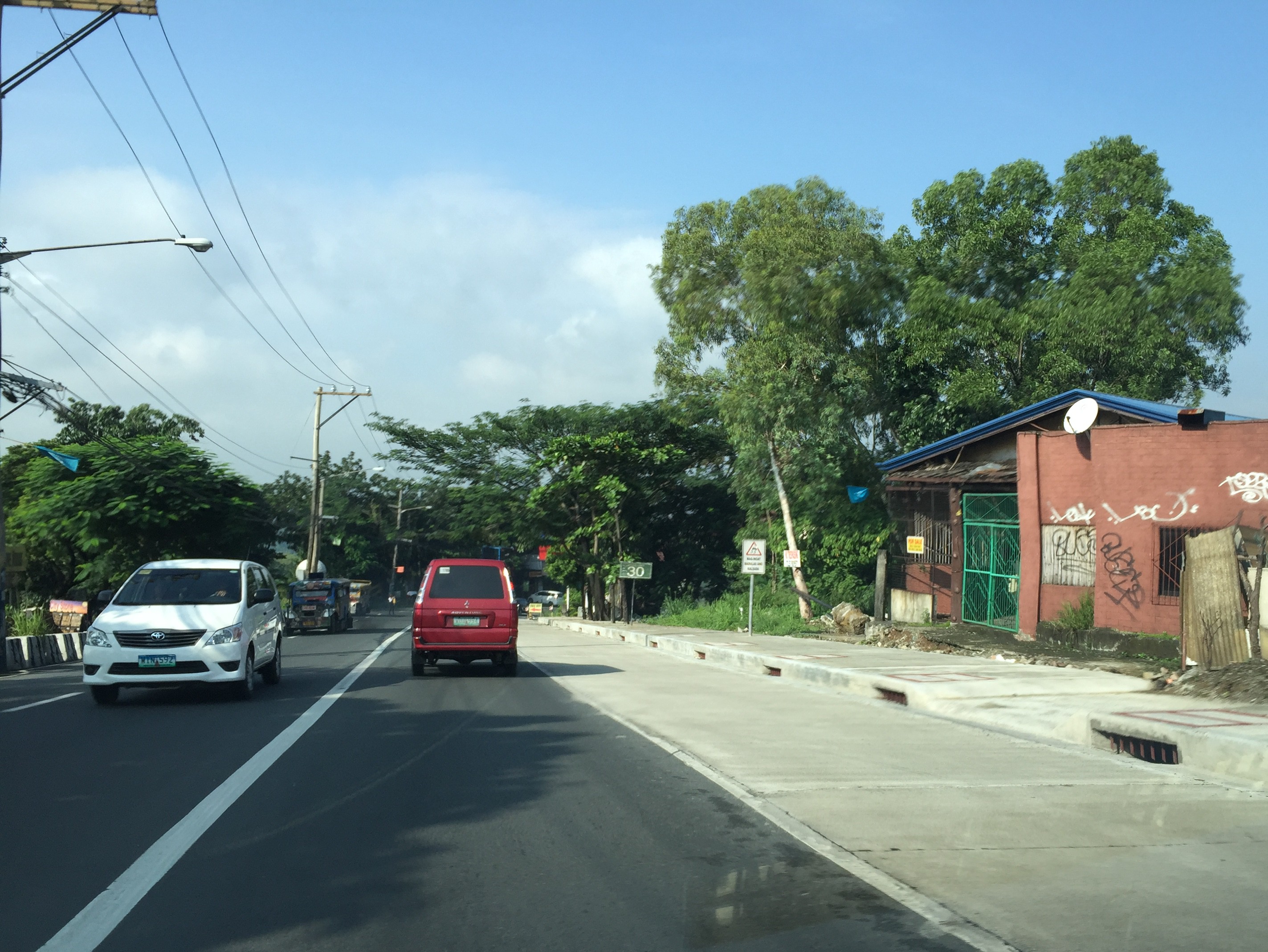
Note in the photo the size and intervals of storm drains along the the highway. Compare this with what we have along most Metro Manila roads including overpasses and it shouldn’t be a surprise why there are frequent flash flooding in Metro Manila. Of course, the capacity of the culverts is a factor (and many are already clogged or barado with garbage and mud) but then it starts with the drains for water to go to the culverts. Many newly rehabilitated roads in Metro Manila have small drains spaced at long intervals. With heavy rainfall, these cannot take in the amount of water given the rate at which they drop from the skies. Perhaps a quick fix to address flash floods is to make these storm drains larger and spaced more closely like those shown in the photo of Sumulong Highway. And then, of course, there should be increased efforts to make sure these drains are not blocked/clogged and that garbage, dirt and other debris will not go straight into the culverts.
–
Roadside views of the Pillila, Rizal Wind Farm
A highlight of our recent road trip to and from Lucena, Quezon via the Rizal – Laguna – Quezon route is the impressive roadside views of the new Pillila Wind Farm. The array consists of 27 turbines, more than the number in Bangui, Ilocos Norte. Following are a few photos of the turbines of the farm which has a total capacity of 5.2 Megawatts. I noticed though that many of the turbines were not running so the capacity is likely not reached and the output highly varies depending on the season and time of day.


There are two access points from the national highway to the wind farm. Via these access roads, one can get near the wind turbines to get photos including ‘selfies’ with the turbines as background, just like those trending photos posted on social media taken at the Bangui Wind Farm.
The Philippines needs more of these clean energy sources. The promotion and spread of such types of energy generation should be able to reduce our dependence on fossil fuels. This would be good in the long run and also for transportation since there are already many initiatives for electric vehicles. E-vehicles are not necessarily zero contributors to air quality and ultimately to climate change if we consider the sources of electricity when these vehicles re-charge their batteries.
–
Local papers presented at the EASTS 2015 conference – Xavier University
I almost forgot to post this article showing the technical papers coming out of Xavier University. Following is the list of papers from Xavier University. Xavier University is basically Ateneo de Cagayan De Oro and is a leading institution in Northern Mindanao in the southern part of the Philippines.
- Sustainable Paratransit: Best Practice Cases in Europe and the Philippines [Martin Smoliner & Anabel Abuzo]
- On-street Parking Evaluation Divisoria, Cagayan De Oro City [David Jorey Alfaro, Francis Camomot, Allison Cyril Escalante, Hipolito Bair & Anabel Abuzo]
- Pavement Distress Evaluation Using Pavement Condition Index around Agora Market, Barangay Lapasan, Cagayan de Oro City [Risa Gwen Martinez & Anabel Abuzo]
- An Analysis of Pedestrian Traffic Safety in Public School Zones in Cagayan de Oro City [Jefferson Vallente Jr., Ferven Cabugao & Anabel Abuzo]
- Agent-Based Mobility Simulation Model for Disaster Response Vehicles [Elvira Yaneza, Gerardo Doroja & Anabel Abuzo]
- A Traffic Congestion Study of Non-signalized Intersections along Yacapin-Capt. Vicente Roa, Yacapin-Osmena, J.R. Borja-Capt. Vicente Roa and J.R. Borja-Osmeña Streets in Cagayan de Oro City [Jude Añana, Kevin Calma, Carlo Flores, Dennis Tantoy & Anabele Abuzo]
Many of the papers are on local problems and very specific to certain streets or areas in Cagayan de Oro City with the exception of the first one in the list, which is on a comparative study of transport in the Philippines and in Europe. Transportation research in Xavier University basically is conducted through its Civil Engineering Department via Dr Anabele Abuzo who obtained her MSCE degree from the University of the Philippines Diliman and her doctorate from the Tokyo Institute of Technology.
–
Causes of congestion – road crashes and shockwaves
I noticed that a previous post on common causes of congestion is popular among those who read this blog. The causes mentioned there focused on the lack of discipline among pedestrians and motorists. Their behaviour (e.g., commuters standing in the middle of the road to get a jeepney or UV Express ride, jeepneys and UV Express stopping in the middle o the road to load/unload passengers, etc.) often lead to congestion as they effectively reduce road capacities.
Another major cause of congestion are road crashes. They don’t have to be fatal crashes as the road capacity reduction caused by stopped vehicles is enough to cause congestion along the road including traffic along the opposite direction. The latter phenomenon, if we can categorise it as such, is due to the inquisitive nature (i.e., uses) of people. Traffic approaching the crash site typically slows down as drivers check what happened. Following are some photos I took as we approached a crash site atop the Marcelo Fernan Bridge connecting the Islands of Cebu and Mactan. Note the build-up of vehicles behind the crash involving 3 vehicles.
 Road crash involving 3 vehicles in the middle of the Marcelo Fernan Bridge in Cebu
 The resulting congestion behind the crash site
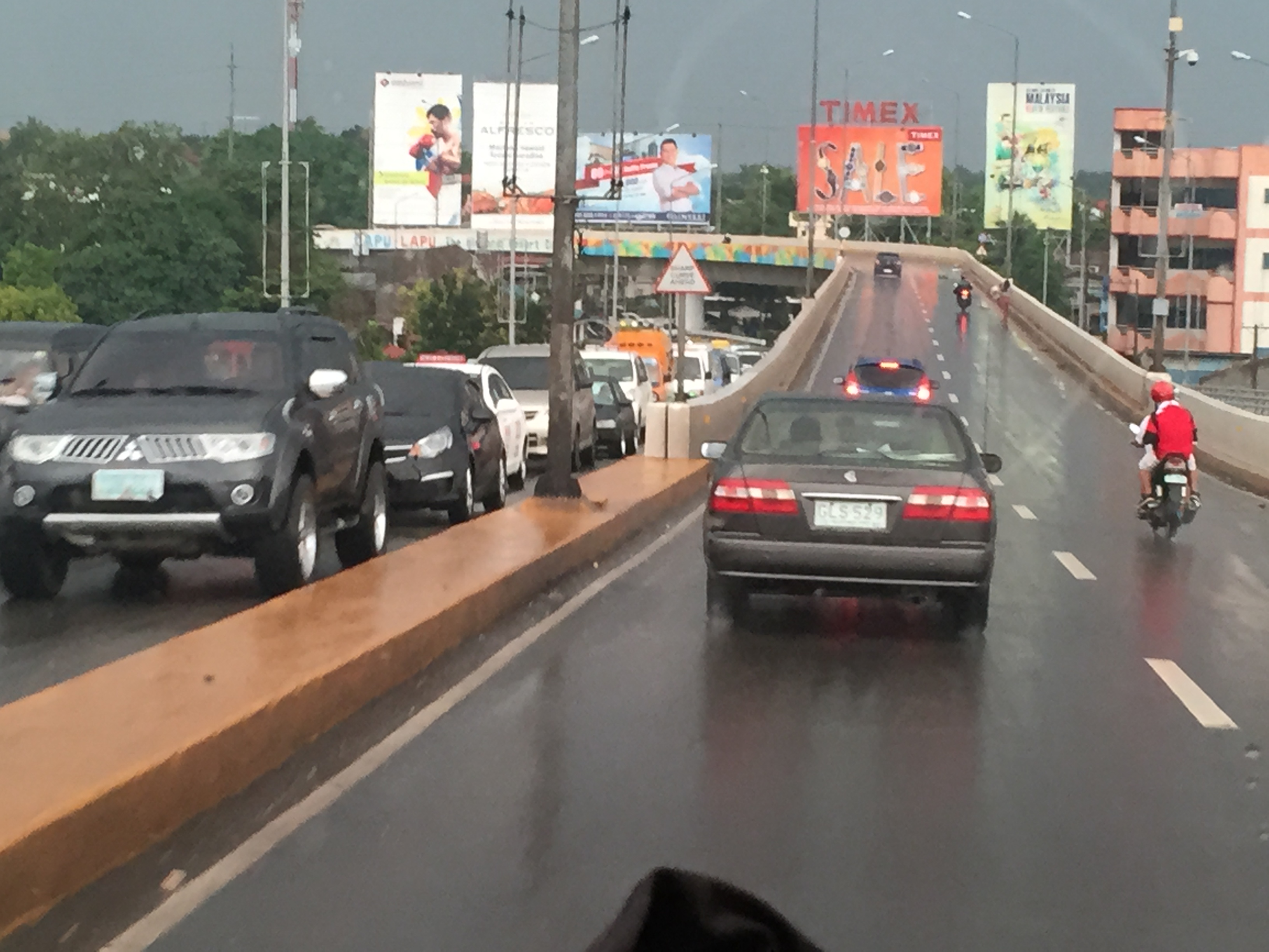 Another view of the vehicle buildup upstream of the crash
Such events are typical causes of congestion and can actually be analysed using traffic flow theory involving waves in traffic. A generally normal flow of traffic (before the incident) is disturbed by the crash, which is assumed to be an isolated event. This results in a change in the traffic characteristics (flow, speed and concentration of vehicles) triggering a shockwave. The shockwave moves backwards and manifests through the chain reaction of drivers hitting their brakes in succession to slow down due to the incident. As such, it is possible to determine how long the build-up of vehicles would be upstream of the incident location.
–
On the Ortigas Avenue counter-flow scheme again
Here are some more recent photos of the morning traffic congestion and counter-flow scheme along Ortigas Avenue. The counterflow scheme starts at the approach to the Manggahan Channel Bridge and ends at the approach to C-5 right after the Rosario Bridge. This counter-flow scheme has been used by Pasig, as far as I can remember, since the early 1980s. Ortigas Avenue is one of those roads where the directional distribution of traffic very pronounced for the peak direction.
 Vehicles crowding towards the counter-flow lane on the eastbound side of Ortigas Avenue. Traffic along this lane is moving, unlike the standstill you will likely experience along the westbound side. This is particularly true at the bridge where buses and jeepneys occupy two lanes and stop for long periods to get passengers. Congestion is exacerbated by vehicles coming out of the residential development in the area. Pasig and MMDA traffic enforcers fail miserably at their duties here. Perhaps this is a job for the PNP-HPG?
 The effort of positioning towards the counter-flow lane is worth it as traffic moves faster here. The argument for counter-flow lanes (or zipper lanes as they are also called) is based on the availability of capacity along traffic lanes of the opposing direction that can be used to optimize utility of these unused lanes (i.e., off-peak direction) by peak traffic. This is a classic transport systems management scheme directed towards efficient and optimum use of existing facilities.
–
Local papers presented at the EASTS 2015 conference – Mapua Institute of Technology
Mapua Institute of Technology (MIT) has a relatively young program under its School of Civil Engineering. This is led by their Dean, Dr Francis Aldrine Uy, who is also active with the Philippine Institute of Civil Engineers (PICE). Mapua has been aggressive the recent years in presenting and publishing papers in transportation engineering and planning. Following are the papers from the MIT:
- Integrated Non-Motorized Transportation System For A Sustainability Oriented Intramuros [Francis Aldrine Uy]
- A Study on the Effectiveness of Eco-Mobility Component: E-Jeepneys in Makati City [Francis Aldrine Uy]
- Comparative Study of the Effects of Fuel Sources (Diesel, Gasoline and Autogas) in Public Transportation in Metro Manila on Price, Emission and Health Issues [Francis Aldrine Uy]
- Determinants of Demands of Pasig River Ferry Service [Francis Aldrine Uy]
- Determination of Cost Impact using Mathematical Model Comprising City Logistics to Quick Service Restaurants in Metro Manila [Francis Aldrine Uy]
- Development of Evacuation Plan by Utilizing Transportation Modeling in the City of Borongan, Eastern Samar [Riches Bacero]
- Operational Performance Analysis of Median U-Turn Intersections as Traffic Control Facility in EDSA [Riches Bacero]
- Community Perception on Trans-operability of Intramuros [Riches Bacero]
- Paradigm Shift Strategy of Inclusive Mobility: The Applicability of Bus Rapid Transit along Commonwealth Avenue [Riches Bacero]
- Evaluation of Strontium Aluminate in Traffic Paint Pavement Marking for Rural and Unilluminated Roads [Riches Bacero]
- Study on the Impact of the Construction Activity of Skyway Stage 3 on Traffic Conditions along Osmeña Highway and San Andres Street [Geoffrey Cueto]
- A Design for Silver Star Integrated Green Bus Terminal [Geoffrey Cueto]
- Proposed Diversion Road to Improve Traffic Movement of Commercially Developed Areas in Bacoor, Cavite [Geoffrey Cueto]
- Establishing the City Logistic Concept in Improving the Freight Distribution in Metro Manila [Geoffrey Cueto]
- An Analysis on the Accessibility Level of Public Transit for Persons with Disability: In care of Light Rail Transit (LRT 1) [Geoffrey Cueto]
- Design and Development of the Puerto Princesa Airport Passenger Terminal [Jocelyn Buluran]
- Design and Development of Passenger Terminal at Batangas Port [Jocelyn Buluran]
- Design and Development of Passenger Terminal Extension of Clark International Airport [Jocelyn Buluran]
- Determinants of “Travel with Dignity” of Passengers of MRT3 [Jocelyn Buluran]
- Integrating Sustainable Non – Motorized Public Transport in the City of Manila, Philippines Through Analytic Hierarchy Process (AHP) [Jocelyn Buluran]
My only comment about certain papers in the list is that many do not seem to be research papers and definitely more on the practice (i.e., design) side than the academic. I can say this based on the presentations made that I was able to attend as well as the papers themselves in the proceedings of the conference that I was able to browse. Still, Mapua has very good potential to come up with good papers from the prolific Dr Uy and his young faculty members led by Engr. Riches Bacero.
The current President of Mapua, Dr Reynaldo Vea, is also the current President of the Transportation Science Society of the Philippines (TSSP). Dr Vea was formerly Dean of UP Diliman’s College of Engineering and Officer-in-charge of UP’s National Center for Transportation Studies (NCTS). His specialty is on maritime transport as he has a degree in naval architecture.
–
Proposals for EDSA and some alternate roads
The hellish traffic congestion along EDSA and other roads in Metro Manila spawned a bunch of ideas for alleviating congestion. Among those that were offered as solutions are the following:
- Odd-Even Scheme – suggested by the Philippines President himself in a speech delivered in Mandaluyong City
- Car-pooling (and HOV lanes) – suggested by the DPWH Secretary in another forum
- Bus Rapid Transit (BRT) and/or express bus – proposed and being studied by the DOTC
What seems to have been forgotten was a proposal to have two lanes of EDSA, one on either direction, devoted to bicycles. This proposal now seems to be the most viable compared to the above three and could have the potential for major behaviour change towards a departure from motor vehicle use. Cycling along with walking does not require fuel and these modes also promote healthy lifestyles. Also, this could become the ultimate example for road diets, which can also be applied along other roads as well. What sounds or reads like an outrageous idea (i.e., bicycle lanes along EDSA) might just be revolutionary and result in what could be a tipping point for sustainable transport in the midst of traffic mayhem.
EDSA has become the proverbial battleground representing the war with traffic congestion. However, EDSA is just one part of our arterial network comprised of circumferential and radial roads. There is also C-5 (also known for its sections – Katipunan, E. Rodriguez, C.P. Garcia), which is also a very congested road but along which there are few fixed route public transport services. It is a primary alternative route (to EDSA)for people traveling between the northern and southern halves of Metro Manila. It also serves as a collector and distributor, being connected with major radial roads like Aurora Boulevard, Ortigas Avenue and Shaw Boulevard as well as to the South Luzon Expressway. C-5 is a major truck route, however, and so carries a lot of heavy vehicles during the permitted times under the truck ban scheme being implemented in Metro Manila. C-5 is already ripe for a mass transit system and should have one along it. The quickest to put up would be a bus system on exclusive lanes. Strategically though, a rail transit line (likely elevated) should already be planned and implemented and with as seamless as possible connections to current and future lines along major corridors.
There are other routes that can be considered which I think have been overlooked (too much focus on EDSA?). C-6, for example, badly needs to be improved and this has started but is being implemented at a slow pace. This could have significant positive impacts on traffic coming from the east (towns of Rizal province) that are bound primarily for Makati and BGC. But then there also has to be a good road bypassing the narrow and already congested streets of Taguig and Pateros that are currently the only roads connecting C-5 and C-6. The roads on the Rizal side (attention: Cainta and Taytay) also need to be improved including Highway 2000 and the Barkadahan Bridge. Perhaps the Rizal Provincial Government should also get involved in this as such routes are in the best interest of Rizalenos. And then there is also the highly urbanized city of Antipolo that is a major destination and already is the 7th most populous city in the country, whose residents also use this route, which is often a faster option to Ortigas and C-5 despite the poor conditions of roads.
–
Local papers presented at the EASTS 2015 conference – De La Salle University
De La Salle University (DLSU) has a strong program in transportation engineering and planning. This program is under its Department of Civil Engineering and led by Dr Alexis Fillone. Following is a list of papers from DLSU:
- Mode Shift Behavior of Bus Passengers to Rail System under Improved Rail Conditions [Alexis Fillone & Germaine Ann Dilay]
- Evaluating Proposed Transportation infrastructure Projects in Metro Manila using the Transport Co-Benefit Analysis [Alexis Fillone]
- Inter-Island Travel Mode Choice Analysis: Western Visayas Region, Philippines [Nicanor Roxas Jr & Alexis Fillone]
- Revisiting Volume-Delay-Functions Used in Transport Studies in Metro Manila [Jiaan Regis Gesalem & Alexis Fillone]
- Characterizing Bus Passenger Demand along Epifanio de los Santos Avenue (EDSA), Metro Manila [Sean Johnlee Ting, Kervin Joshua Lucas & Alexis Fillone]
- Optimized Bus Schedules in Epifanio Delos Santos Avenue (EDSA), Metro Manila Using Fuzzy Rule-Based System [Alexis Fillone, Elmer Dadios & Ramon Intal]
- Opinion Survey about Pedestrianization of Heritage Sites in the City of Iloilo, Philippines [Alexis Fillone & Frederick Sosuan]
- Factors Influencing Footbridge Usage Along Epifanio Delos Santos Avenue (EDSA), Metro Manila [Aaron King, Rigel Cadag, Jireh Despabiladeras, Rei Tumambing & Alexis Fillone]
- A Compact Scheduling and Revenue Estimation Spreadsheet for Bus Operators [Raymund Abad & Alexis Fillone]
- Adaptive Driving Route of Busses along Epifanio de los Santos Avenue (EDSA), Metro Manila, using Fuzzy Logic [Alexis Fillone, Bernard Yasay & Elmer Dadios]
I thought DLSU could have published more papers in this conference. I was actually surprised that all the papers are practically attributed to Dr Fillone considering his co-authors are mostly his students. But then there are only 2 to 3 faculty members who are doing transport research in DLSU and Dr Fillone is the most involved and prolific among them in terms of published research outputs.
–
