
Home » 2017 (Page 8)
Yearly Archives: 2017
On distracted driving vs. other, more urgent, traffic issues
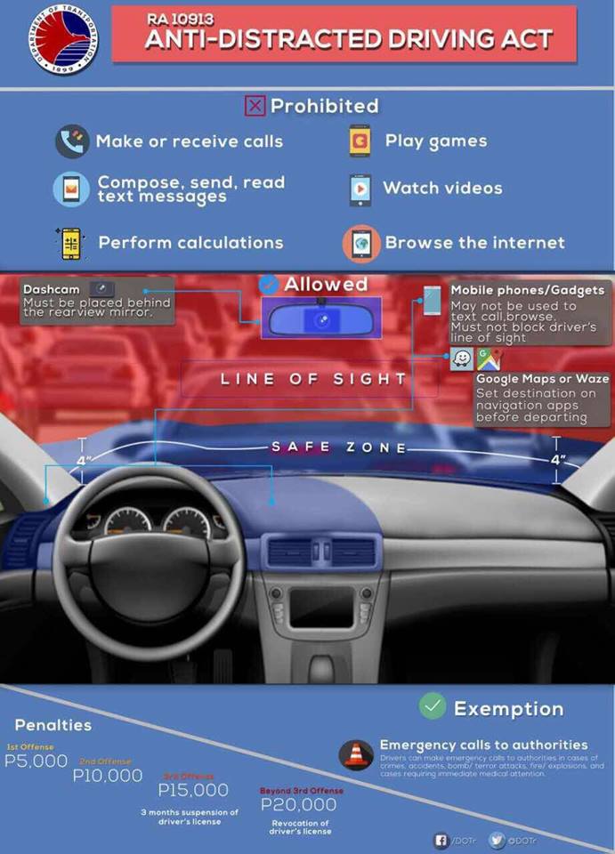
Much has been written and said about the new law against distracted driving. The people who crafted the law, Senators and Congressmen, are in agreement that their intention was mainly to address the rampant use of gadgets including cell phones by motorists. Yet, when the agencies in-charge of implementation drew up the implementing rules and regulations (IRR), their interpretation was the subject of a lot of complaints. Many opined that the IRR didn’t take into consideration actual vehicle dashboard designs or that the definition of the term “line of sight” was open to interpretation. This necessitated another round of consultations with stakeholders leading to the infographic below:
Frankly, I am more concerned about speeding, counter flowing and reckless weaving in traffic. These are equally if not more dangerous than many aspects of the distracted driving law. Quite serious would be the combination of distractions with any of the three behaviors mentioned. More disturbing would be the deliberate (definitely not distracted) or conscious acts of speeding, counter flowing and reckless weaving that are often the cases if one observes the incidence of these three driving behavior. We can only wonder about the likelihood of crashes due to these behaviors.
–
On slippery roads again
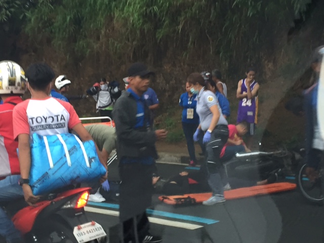
With the onset of the wet season, expect many roads to be slippery during and after rains. As such, extra care should be exercised by travelers especially motorists. It is easy to lose control of vehicles, especially motorcycles, when speeding or undertaking risky maneuvers like overtaking, counter flowing, and tailgating. Traffic enforcement units also need to be active in accosting motorists for risky behavior that may endanger the lives of not only the vehicle occupants but of other people as well like innocent pedestrians and cyclists minding their own business.
Following are a couple of photos of an incident along Sumulong Highway after rains in the area. Apparently, only a motorcycle rider was involved in what seems to be something that would be categorized as a “self accident”. No other motorists may have been involved although I suspect it could also be a case of a “near miss” where the rider lost control after almost hitting or being hit by an errant vehicle.

–
Back to school – concerns about congestion and safety
Many roads again are expected to become more congested as school resumes in most parts of the country especially in cities. But while congestion is usually the top issue along roads near many schools, one concern that usually takes a back seat to congestion is safety. Many public schools in the provinces are located along national highways. Many if not most of their students walk to and from school, usually on the carriageway when the shoulders are too rough, dusty or muddy. This situation for students increase the likelihood of their being hit by vehicles using the road. The risk increases because of their exposure to the dangers posed by motor vehicles. Following are a couple of photos showing typical cases at public schools along national roads. Both are in Antipolo City.
 Typical at-grade pedestrian crossing in front of a school. Students in most public schools often commute by walking or taking public transport like jeepneys or tricycles.
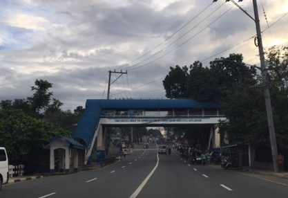 Despite this pedestrian overpass across a public school along Sumulong Highway, most students still prefer to cross on the road rather than go up and down the overpass.
Oftentimes, the seemingly obvious solution of constructing overpasses for safer crossings for students does not pan out as planned or intended. There are many underutilized pedestrian bridges since the natural way is still to cross at-grade. Then there is the issue of providing them safer walking paths or walkways. In both photos above, the sidewalks are only token (“puwede na iyan”) and insufficient for the pedestrian traffic supposed to use them. We need to plan, design and provide such facilities for our pedestrians, especially children, who are marginalized compared to those who have their own vehicles for travel.
–
Some updates on C-6
I have not used Circumferential Road 6 in a while. And so a couple of weeks ago, I was happy to see that work has resumed on the sections at Lupang Arenda in Taytay, Rizal, which is also known as Sampaguita Street. Here are some photos of the wide C-6 section. I guess there’s an opportunity here to have service roads on either side of the highway in order to manage/control local traffic. C-6, after all, is a highway and is designed for typical national highway speeds (i.e., 60 kph). The adjacent land use, however, requires slower traffic mainly due to safety concerns.
 Cordoned-off section where a contractor is preparing the sub-base prior to placing the steel reinforcement and pouring concrete
 Another photo of the section showing form works for the slab. Note the parked vehicles along the side on the left.
 Some sections are already flooded from the heavy rains
 The completed section towards Nagpayong, Pasig is a wide 4 lanes. At left is a nice view of the Laguna de Bai.
 Section to Nagpayong near the boundary of Taytay, Rizal and Pasig City.
 That’s a habal-habal (motorcycle taxi) terminal on the left and in front of a parked jeepney.
Two very important things about C-6 though. One concerns the Barkadahan Bridge over the Manggahan Floodway, which is too narrow for the traffic that cross it. There’s a new bridge beside it that seems to be taking too long to build. And then there’s the long stretch from Nagpayong, Pasig to Lower Bicutan, Taguig which remain in bad condition. The new section along the lakeside is already usable for Pasig-bound traffic but needs to be allowed to carry two-way traffic for the older section to be rehabilitated. C-6 is becoming a major alternative route for a lot of travelers from Rizal to and from Makati and Taguig (esp. BGC). It needs to be improved immediately as it can help decongest the Ortigas Ave. – C5 route that most Rizalenos use to go to their workplaces.
–
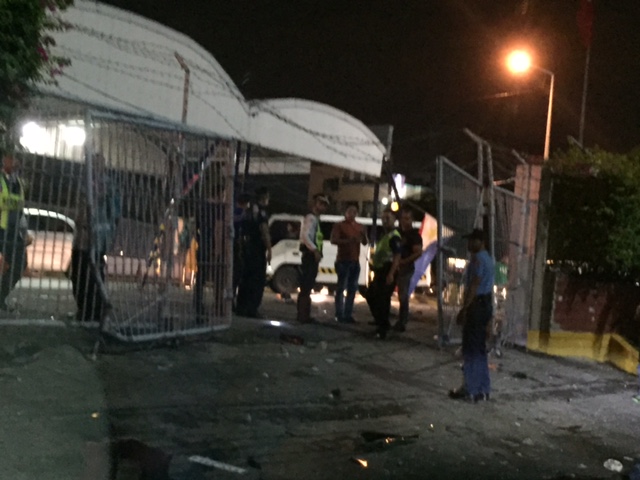
Road crash at NAIA Terminal 1 parking area
[Warning graphic content]
Last May 30, I was picking up my wife at the airport and heard a loud crash as I was getting my ticket for the NAIA Terminal 1 parking lot. I looked around but could not see anything that could concern me. As I rounded the driveway though, I noticed the vehicles in front of me already slowing down. This was the scene that greeted us:
 Van in an awkward position against the bushes of the parking lot fence and after colliding with a parked SUV. Security staff were already there and one person (the driver of the van?) seemed out of sorts.
As I continued my drive, I saw this gruesome scene of a person who was likely hit by the van when it crashed into the limited access gate of the parking lot:
 The casualty of the incident was lying on the ground with security personnel apparently more concerned about the damaged gate than attending to the person.
 Another look at the damaged gate that the van punched through before finally crashing into the SUV and the bushes as shown in the first photo.
I’m not sure if this incident was featured in the news. It surely is something that would likely be not attract so much attention as it may not be as ‘newsworthy’ as other incidents that have happened recently. That is often the case with road crashes, which seem to be regarded as something typically occurring.
One thing we get and should realize from this is that everyone is indeed vulnerable from road crashes. The casualty in the photo (I assume only one) was likely someone who was there waiting for a relative or a client to arrive. Large groups and even whole families may be found at the airport parking lot as they wait for loved ones to arrive. The victim probably was just wiling his time, even texting people about his status, when tragedy struck that night.
–
Submersible bridge in Montalban
Last May, we went to a zoo in Rodriguez (formerly Montalban), Rizal. Using Waze for directions to the zoo, the app took us to a submersible bridge across the wide Marikina River from the main highway (M.H. Del Pilar) to the mainly residential area where the zoo was located. Following are photos of the submersible bridge and the newer more conventional bridge located a little further down the highway.
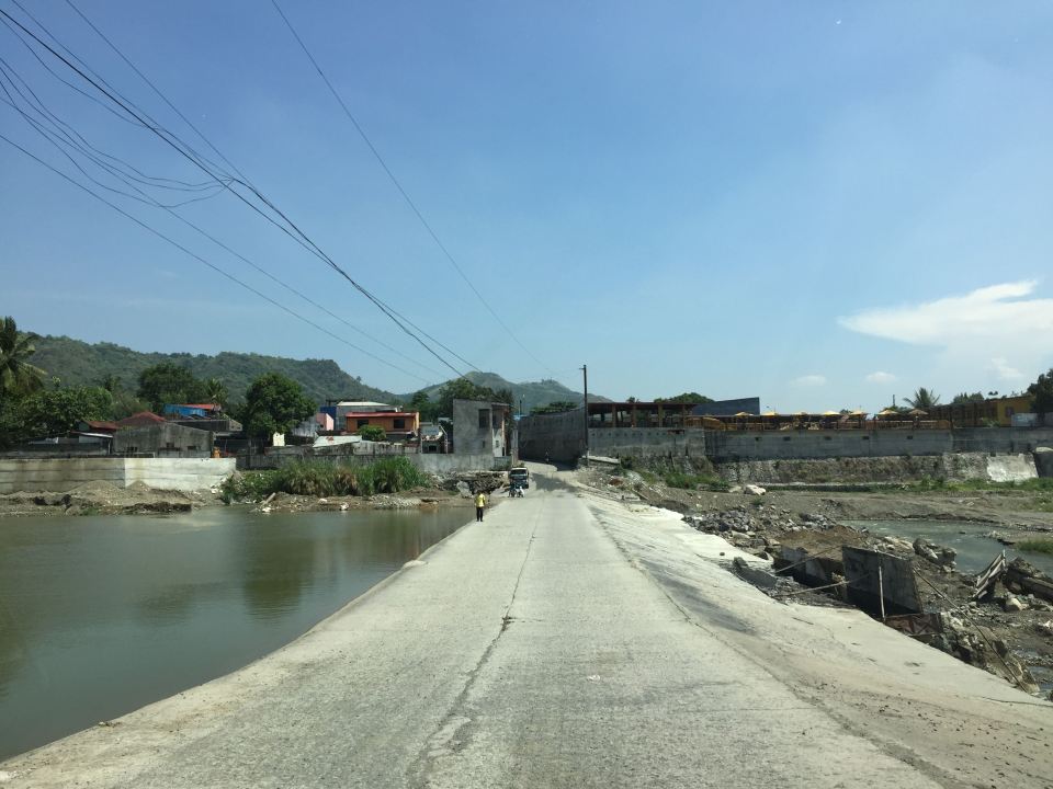 Submersible bridge connecting Barangay San Rafael with Barangay San Isidro
 The “all-weather” bridge as seen from the submersible
There are many bridges like this submersible one across the country. Many were built as weirs or dams that could be used as bridges when the water level allowed it but could let water pass above it during wetter days. Incidentally, there’s one along a popular alternative route between Quezon City and Marikina in Tumana. That bridge can be impassable during times of heavy rains.
–
On low income cyclists
There are two articles that I want to share here. These are quite interesting for me as they tackle something not usually written about when it comes to cycling. The “invisible biker” referred to in one of the articles is the typical low-income cyclist. These are those who can be seen regularly using their bicycles to commute to and from their workplaces; likely to save hard-earned money for more important items such as food and shelter (rent?). They do not use fancy bicycles like those nice, branded mountain, road or fat bikes that you see being used by recreational bikers or weekend cyclists. They most likely use second-hand bikes like those surplus bicycles from Japan, or perhaps old BMX’s that have been modified to make it a bit more comfortable for the long commutes.
Quednau, R. (2017) The Invisible Bike Riders, Strong Towns, http://www.strongtowns.org, May 2.
Koeppel, D. (2015) How Low-Income Cyclists Go Unnoticed, Bicycling, http://www.bicycling.com, November 9.
I think these are the bike riders that we should be providing safe bikeways for. They are the ones who most often use bicycles for their trips and are at risk of being hit by motor vehicles.
–
Construction starts for the Line 2 Masinag Station
After several months of waiting, the Masinag Station of the Line 2 Extension project will finally start construction. The contractor has already mobilized and very soon the actual construction work will be starting. Following are photos I captured via my dash cam:
 The contractor, DMCI, already installed temporary traffic signs from Masinag Junction.
 The contractor, DMCI, also already installed concrete barriers to delineate their staging area for the project.
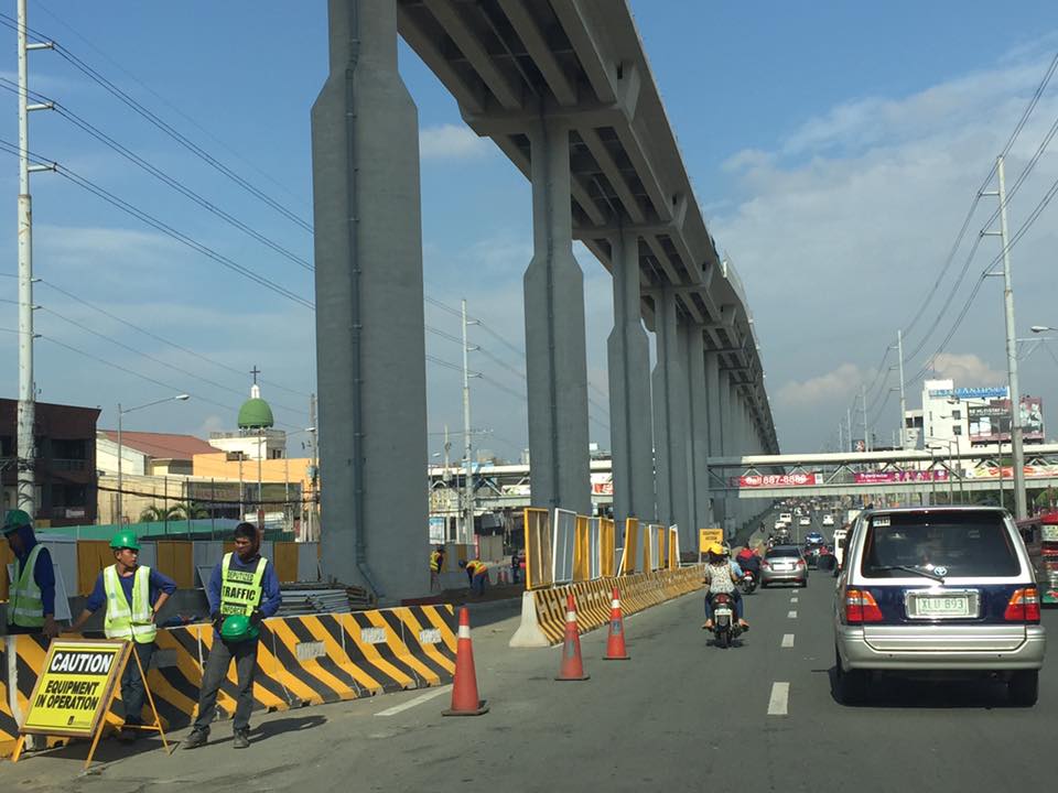 This is the likely location of the elevated Masinag Station; right across SM City Masinag and Cornell Hospital.
Masinag Station will probably be the highest station for any railways in the entire country judging from the height of the elevated tracks. I have yet to see the plans for this station but it should be a challenge in accessibility. How many steps would it take to go up or down the station and the platforms? How will, and will it be integrated with the surrounding developments like SM?
The Antipolo City Government’s official Facebook page already announced the official ceremony starting the construction to be held on May 30, 2017 (Tuesday). The advisory also cautioned travelers about the traffic congestion expected in the area affected by the construction. Masinag is a major junction where Marcos Highway and Sumulong Highway intersect. Construction period will be 18 months or 1.5 years but given the efficiency by which the same contractor was able to complete the elevated tracks, I am optimistic that they may be able to complete Masinag Station in less time. I wonder though if the ceremony tomorrow also includes the start of construction for the Emerald Station across Robinsons Metro East in Pasig. Let’s just hope that the Line 2 Extension will be operational by end of 2018 and be able to help alleviate the traffic woes along its corridor. This will definitely help improve the transport to the east of Metro Manila and directly benefit those from Antipolo and Cainta in Rizal, and Marikina and Pasig in Metro Manila.
–
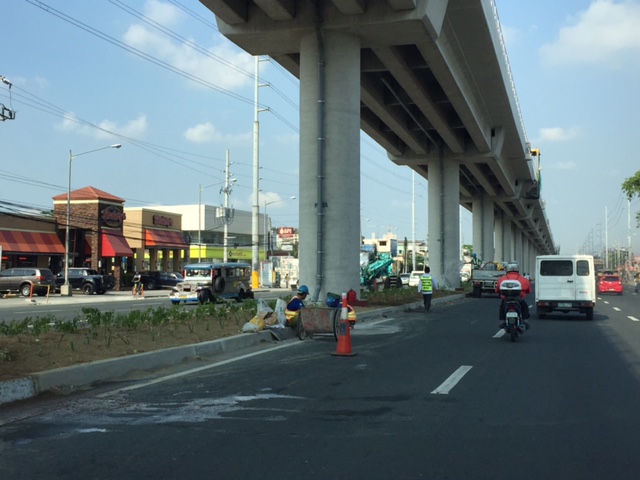
Landscaping for the LRT Line 2 Extension
A friend posted about the removal of trees along the median of Commonwealth Avenue as part of the construction of the MRT Line 7 in Quezon City. Many if not all trees in the Fairview area have been cut or balled. A similar thing happened during the construction of the Line 2 Extension from Santolan, Pasig City to Masinag, Antipolo City. All the plants and trees along the median island were removed to give way to the construction of the elevated tracked of Line 2. Recently though, as the median has been cleared of construction materials and equipment, landscaping work was implemented. This makes sense considering there is enough space to make the area underneath the elevated tracks green. Trees and other plants can grow here providing a natural barrier for traffic as well as to improve the overall environment along Line 2.
Following are photos taken as we passed by Marcos Highway, taken a few weeks ago. Some of the plants have survived and but many seem to have simply dried up. Wha seems to be the early arrival of the wet season should help bring life to the plants under the elevated tracks of Line 2.

–
On e-tricycles again
This is also another late post. I was driving in Tagaytay when I spotted these electric tricycles near the junction of Aguinaldo Highway and the Tagaytay-Nasugbu Road. It was the first time for me to see these e-trike models that obviously got inspiration from the tuktuks of Thailand.
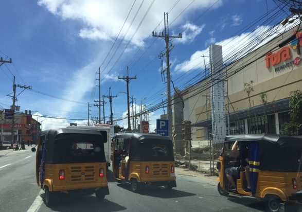
Counterflowing, racing, or maneuvering just about anywhere their drivers seem fit mean these e-trikes are operated just like their more conventional relatives. While their deployment are supposed to ease air pollution attributed to the exhausts of conventional tricycles, these likely will not contribute to easing traffic congestion in Tagaytay. I wonder though if these e-trikes are replacing the conventional ones. Many LGUs seem to have embraced e-trikes but as additional units to the current ones comprised of legal and illegal (colorum) trikes. Too often, LGUs are too careful in phasing out the old tricycles fearing a social backlash that can affect votes whenever there are elections. And so they could not properly address public transport issues directly pertaining to tricycle operations leading to worsening transport and traffic conditions especially in the CBDs.
–
