
On building the ideal city from a transportation perspective
There’s a not so old article that popped in my timeline of articles I’ve read the past years. I thought I would make a quick share of it here. It is a good read and something that will never be irrelevant for as long as we have not redeveloped our cities and municipalities for transport equity and sustainability. Here’s a takeaway from the article:
“The ideal city is a place where lots of different kinds of people with lots of different amounts of money can live and work. It has to be easy to get around without a car, even for people whose bodies can’t ride bikes or hop over potholes, and for people who have kids to drop off on the way to work and groceries to buy on the way home, and maybe flowers to buy next door to the dry cleaner’s. These are places where people want to live, because it’s nice there. The fact that those places also adapt to and mitigate climate change instead of causing it is a bonus.”
Here’s the article from last year:
Rogers, A. (April 1, 2020) “Build Cities for Bikes, Buses, and Feet—Not Cars,” Wired, https://www.wired.com/story/cities-without-cars-san-francisco-jeff-tumlin/?bxid=5bd6761b3f92a41245dde413&cndid=37243643&esrc=AUTO_OTHER&source=EDT_WIR_NEWSLETTER_0_ENGAGEMENT_ZZ&utm_brand=wired&utm_campaign=aud-dev&utm_mailing=WIR_Classics_042921&utm_medium=email&utm_source=nl&utm_term=WIR_Daily_TopClickers [Last accessed: 4/30/2021]
–
On when to use masks when outdoors
Here is a useful graphic from the US Centers for Disease Control and Prevention. The graphic described situations for when masks are required. I don’t want to use preferred because it means people may opt out of using masks. It is a useful reference even for those in other countries that do not have enough clear information from their governments about wearing masks and how it helps protect vs. getting infected by Covid-19. It is applicable to people searching for a legit reference to mask-wearing in outdoor situations.

This information becomes more relevant as people start getting vaccinated and at the same time look forward to getting together with family and friends in social events such as eating out or having picnics. Of course, this also applies to exercise as well as commuting via active transport modes (i.e., walking or cycling).
–
Inter-island bridges in the Philippines – Nice to have but not necessary at this time?
A news article came out yesterday, reporting on the shelving of several inter-island bridge projects as well as the progress of only 3 projects include the Panguil Bay Bridge. Many of these projects have been conceptualized a long time ago but were being fleshed out through various feasibility studies.
I’ve written before about these bridges, and had a healthy discussion among friends about the merits and demerits of such infrastructure when there are other, more urgent projects that would probably have higher impacts. One friend was involved in studying the connection between Panay and Negros islands, and had concluded that the cost can be justified by the economic benefits brought about by the bridge. I disagreed, stating the costs could cover modern urban transit systems at least in the major cities of Iloilo and Bacolod.
With limited resources and the likelihood of these projects being funded from various foreign loans make them unpalatable since these will mean more debt for the country. Also, these projects will benefit fewer people compared to other transport projects including modernizing public transportation and building bike lane networks. The latter kinds of projects are for daily commuters whereas the bridges are more for occasional travelers. What do you think?
–
Is there a supply problem with public transport in NCR plus?
I initially wanted to use “Philippines” or “Metro Manila” instead of “NCR Plus” for the title of this post. I dropped “Philippines” in order to be more specific and also because I am not so aware of the situation in other cities outside Mega Manila. I also decided vs. “Metro Manila” because transport for the metropolis is tightly woven with the surrounding areas where many people working or studying in MM actually reside. These include the towns of Bulacan, Rizal, Laguna and Cavite.
So, is there a supply problem with public transport in what is dubbed as NCR+? The photos in social media appear to describe a lack of public transport vehicles with many people lined up along major roads, queued at terminals or train stations. These photos do not lie where they were taken. Indeed there is a big problem about supply along certain corridors due to certain factors such as limited number of public utility vehicles (mainly jitneys and buses) allowed operation and health protocols that limit the passenger capacities of vehicles. The latter also applies to rail services where despite rolling stocks being back to pre-pandemic operations, are limited to the number of people they can carry. Crush loads are a no-no during these times.
Traffic congestion and its effects on PUV turnaround times, however, is another major factor for what may seem like a lack of supply. Most road-based public transport operate in mixed traffic. As such, their operations are susceptible to traffic conditions along their routes. So it is very likely that during the peak periods, PUVs get stuck along the peak direction and take much time to return despite the lighter traffic along the return trip. The problem for some routes though is that during peak periods both directions are congested. This further exacerbates the situation for public transport as vehicles would have to go through a two-way gauntlet of sorts, resulting in a lot of people taking longer to get their rides. And so for those who have access to private transport do go back to using private vehicles.
Definitely and obviously, there is a mode choice issue here because many people appear to have taken private transport as their mode of choice instead of public or active transport modes. This is mainly attributed to the perception that public transport is unsafe or less safe compared to your own vehicle in the context of the current pandemic. We qualify the current health situation here since that seems to be the main driver for people choosing to take their cars apart from that other perception of the poor quality of service provided by public transport in general. For active transport, the reality is not everyone or not a lot of people will choose to walk or cycle along roads that are generally regarded as unsafe despite efforts to put up bike lanes. Those who are having problems commuting are those dependent on public transport also because of their long commutes between the residential outside or in the outskirts of Metro Manila and the CBDs in the metropolis.
The dilemma here is determining which routes would actually require additional vehicles. While the general perception and temptation is to add vehicles everywhere, it’s the actual numbers that need to be estimated based on the information that needs to be collected (as against available data, which can be unreliable). The situation and the data for different routes varies much.
Case in point is the experience along the Antipolo-Cubao route that used to be served by jeepneys. Buses now serve that route after the government rationalized the service. Initially, there were fewer buses operating along the route that had a large catchment area for passengers. Additional buses were deployed in order to address supply issues (again many passengers were not able to get their rides for the same reasons we mentioned earlier). Now, there seems to be enough buses for the peak periods but a surplus during the off-peak. Passengers along other routes are not as lucky as those served by the Antipolo-Cubao buses.
Public transport operations will not survive such variations in demand if they continue to operate under the old “boundary” or rental scheme. So, there has to be a subsidy somewhere for them to operate under these conditions. And that’s where service contracting comes in. While I agree that this is essential for transport reform, we still have limited resources, and it will not be sustainable in the long run if we cannot make people take public transport over private vehicle options.
–
On how communities should be?
This post is related to my recent post about Philippine cities and municipalities already somehow being 15-minute units. I am sharing another article I’ve read and reread for its current relevance.
Litman, T. (March 15, 2021) “A Complete Community is All Mixed-up,” Planetizen, https://www.planetizen.com/node/112565?utm_source=newswire&utm_medium=email&utm_campaign=news-03222021&mc_cid=628c8ee4b1&mc_eid=9ccfe464b1 [Last accessed:
The article is loaded with references that you can download and use in research or practice. And there are these two tables – Walk Score Ratings and Public Amenities – that are quick guides or references to what is desired to be achieved in communities.
Enjoy!
–
On what local governments can do to improve road safety
Here is a very interesting article on how a small city in the US was able to reduce traffic deaths by investing in people-oriented transport programs and projects:
Kessler, E. (April 6, 2021) “EYES ON THE STREET: How Hoboken Has Eliminated Traffic Deaths,” StreetsBlog NYC, https://nyc.streetsblog.org/2021/04/06/eyes-on-the-street-how-hoboken-has-eliminated-traffic-deaths/ [Last accessed: 4/14/2021]
The article is pretty much self-explanatory. I won’t be commenting more about this except that many of the items mentioned can be taken on by many cities and municipalities in the Philippines. You don’t have to be a highly urbanized city with a big population and so much resources to come up with a plan and perhaps improvise in order to reduce costs of implementation. The most important thing is leadership since leaders like the mayor will be responsible for and making the critical decisions for the town. That is why he was elected in the first place, and the same goes for the other elected officials who are supposed to represent the interests of all their constituents and not just those who own cars.
–
If you build the bike lanes, will people use them?
The obvious answer to this question is yes. It is not so clear, however, how many will really be using these bike lanes over time. That needs data. That requires counting. And such data will be useful in order to understand, among other things, why people choose to bike or why they don’t. The latter is important to determine what factors are being considered by people who can switch to cycling particularly for commuting. Of course, there are many references for this from other cities and countries but these still need to be contextualized from our (Philippine) perspective. Case in point is Marikina, which has the most comprehensive network of bike lanes in the country. What are the numbers and what are the constraints and misconceptions? Did the city do its part to promote and sustain cycling?
Here is an article discussing the experience in the US:
Penney, V. (April 1, 2021) “If You Build It, They Will Bike: Pop-Up Lanes Increased Cycling During Pandemic,” The New York Times, https://www.nytimes.com/2021/04/01/climate/bikes-climate-change.html?smid=url-share [Last accessed: 4/9/2021]
 Bike lane along Katipunan Avenue (C5) in Quezon City
Here is the link to the paper mentioned in the article:
https://www.pnas.org/content/118/15/e2024399118
–
Didn’t we already have 15-minute cities and towns in the Philippines?
I was reading about articles and posts in social media about the ’15-minute’ city. The concept basically states that your home should be within 15 minutes of necessary destinations such as the market, the grocery store, the drug store, hospital, police station, and maybe perhaps the government office.
To quote:
“The core principles behind the 15-minute city aren’t new to urban planning. They derive from an old history of designing cities around people rather than cars, and many European cities that were planned before the invention of the automobile are better suited to this notion. But the idea that has been popularized during the pandemic is that all cities — including European ones — must center future planning on the goal of ensuring car-free access to basic necessities, such as health care, schools, employment and food. It’s a lofty goal, but one that is unlikely to reach all neighborhoods in many cities without drastic interventions and investments. Pitter warns that simply injecting design changes such as bike lanes and parklets into a neighborhood will not reverse segregation that has been embedded into city planning.” O’Sullivan in “Where the ’15-Minute City’ Falls Short”
Many of our cities and municipalities date to the Spanish times or older (e.g., Manila, Cebu). Those that developed during the Spanish period were planned according to European cities. You know, with the church, government (i.e., municipal hall), market and school located at the center. Residential and commercial establishments surround the center, which often had a plaza. And, as the saying goes, the further you were from the center (i.e., the fainter the sound of the church bells), the lesser you are as far as society goes. This set-up still applies now and arguably sari-sari stores, which were the convenience stores of old, are now being replaced by convenience store chains like 7/11 and Family Mart. Commerce-wise, it helps that big companies like SM, Robinsons and Puregold have smaller stores spread around. And hospitals like Medical City have smaller clinics and laboratories. Wet markets? Surely there are talipapas if you just check around you.
Even now, if you look around closely, the only likely exceptions to the 15-minute city concept would be concerning the workplaces and schools. Many people live more than 15 minutes from their workplaces, enduring ‘painful’ or ‘wasteful’ commutes on a daily basis. The same goes with students who are enrolled in their or their parents’ preferred schools. Note that the public school system in the Philippines, despite its being maligned, has pre-school, elementary and high school campuses or buildings located strategically in each barangay. That would mean short commutes for students enrolled in these schools which prioritize residents of the barangays. However, many prefer private schools (e.g., Ateneo, LaSalle, St. Scholastica, St. Paul, Assumption, etc.) or elite public schools (i.e., science high schools) and so even children have to endure long commutes.
So do you still think we don’t have 15-minute cities in the Philippines?
–
On the principles of good infrastructure
Since the Philippine government is engaged in its Build, Build, Build infrastructure development program, and agencies like the DPWH and DOTr often or regularly refer to what’s happening in the US in terms of projects, guidelines and standards, I am sharing the following article on the principle
Marshall, A. (March 18, 2021)“What Are the Five Principles of Good Infrastructure?” Governing.com, https://www.governing.com/community/Five-Principles-Good-Infrastructure.html [Last accessed: 4/5/2021]
Despite obviously being an article about US infrastructure in the context of the new administration there, there are just too many takeaways or relevant information here that applies to us and how we are developing and maintaining our infrastructure. To quote:
“First of all, cost matters. The evidence is pretty clear now that we pay several times more than other advanced nations to build transit infrastructure, particularly tunnels, and possibly highways as well. It appears we pay too much to build public parks.
Second, time matters. We still get estimates for infrastructure projects whose construction stretches into decades, when it should be a few years. Time relates to cost. Adding time makes projects more expensive.
Third, connections matter. Whether it’s a light-rail line joining up to a bus line, or an interstate exit linking to a town, the connections between infrastructure systems are important. High-speed rail lines need to intersect seamlessly with the cities they serve. Infrastructure can’t be designed in a vacuum. Urban planners and designers should be at the top of the infrastructure food chain, so that transportation and other departments work for comprehensive visions.
Fourth, design matters. Western Europe has been erecting light, airy bridges for decades, while we have continued to build heavy concrete slabs. This is changing, but we lag behind other countries in the design quality of everything from bridges to subways.
Finally, ownership matters. Even the best-designed and swiftly built infrastructure will turn bad if we give one or two private companies total control over them. As we use private companies for broadband, cable, telephones, data management and the power that runs our homes, we need to remember this. When we can’t (or won’t) have public systems, then the private ones need to be carefully managed.”
To what extent do you think these principles apply to our case?
–
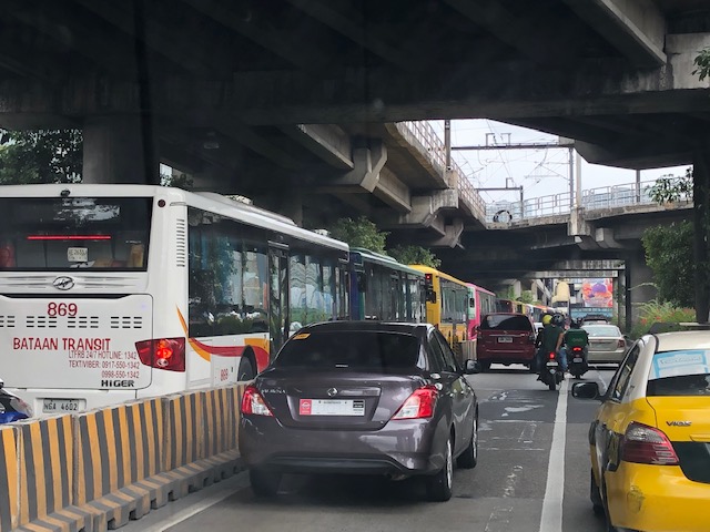
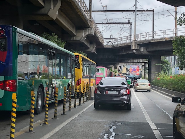
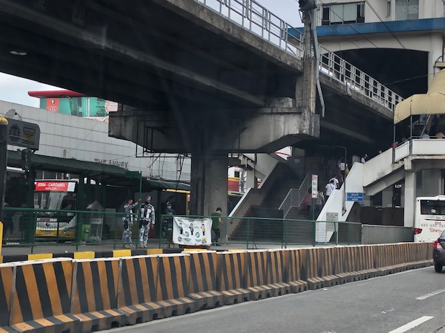
Some observations and thoughts about the EDSA carousel
Much has been written or said about the EDSA Carousel. This is the express bus service the government implemented along Metro Manila’s busiest thoroughfare, EDSA or Circumferential Road 4. I feel that it is a decent effort from government to address the lack of supply to address the huge demand for public transport along EDSA considering that it serves to also distribute trips collected from major roads connecting to it. Is it an admission of something wrong in terms of the transport infrastructure along EDSA? Perhaps and from the current administration and DOTr. The admission of flaws certainly did not or will not come from the previous administrations that failed to address problems pertaining to Line 3 including maintenance and operations issues.
 Buses queued before the Trinoma/North Avenue Station of the carousel. Overhead is the junction to the EDSA-MRT depot underneath Trinoma.
 The overhead junction is the MRT’s branch to/from the depot
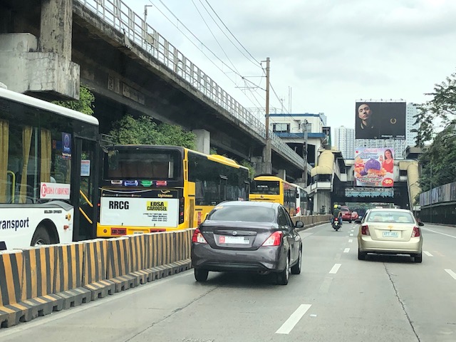 Buses queuing towards the North Avenue Station
 The carousel stations are basically part of the MRT station with the platform located at ground level at the otherwise underutilized space that is the median island of EDSA. Access to the express buses are via the MRT stations as there are no other means for crossing to/from the carousel berths.
The carousel is an attempt to have a Bus Rapid Transit (BRT) along EDSA. It is perhaps the most practical solution to supplementing the already limited capacity of elevated Line 3 despite the continued operations of regular buses. The express bus service is not a new idea along EDSA since Line 3 had to compete with a BRT proposal (though it didn’t use the term BRT then) back in the 1990s. Insiders at NEDA relate that it was then President Fidel V. Ramos himself who allegedly ‘lobbied’ for the MRT instead of an elevated bus transit system. Unfortunately, the MRT proposed, constructed and now in operation is a light rail system like Line 1 and could not easily be upgraded to a heavy rail system like Line 2 or the future Line 7. The line is already problematic due to maintenance issues and the aging rolling stock. And there are questions regarding interoperability with Line 1 (definitely not interoperable with Line 7). So the grand central station currently under construction will really be a terminus for 3 lines as trains will not be able to pass through to other lines like how it is in other countries.
Will the carousel be a permanent fixture along EDSA? Perhaps. But it should be improved further for the convenience of commuters as well as for more efficient operations. The current buses being used are the not the right vehicles if capacity is to be maximized. Articulated buses would be necessary for this purpose. The current barriers should also be replaced with more appropriate and perhaps more clever designs partly for aesthetics but for the system to be safer and more functional in terms of spaces for passengers and vehicles.
–
