
Home » active transport (Page 2)
Category Archives: active transport
The mobile stores of my childhood days
I took a photo of this animal (cow) drawn cart as we passed it in Taytay en route to Makati via C-6. These used to be larger and wagons drawn by one or even two animals (usually cows or bulls). Families lived in those wagons and were somewhat nomadic in a sense that they traveled while selling products like walis tambo (brooms for indoor use like those in the photo), walis tingting (brooms made of coconut stems also in the photo to the rear of the cart), baskets, and other handicrafts. I have memories of their regular if not frequent visits to our village in Cainta in the 1970s and early 1980s. Eventually, they vanished. I see some from time to time but only like the one in the photo below. I have not seen the larger wagons.
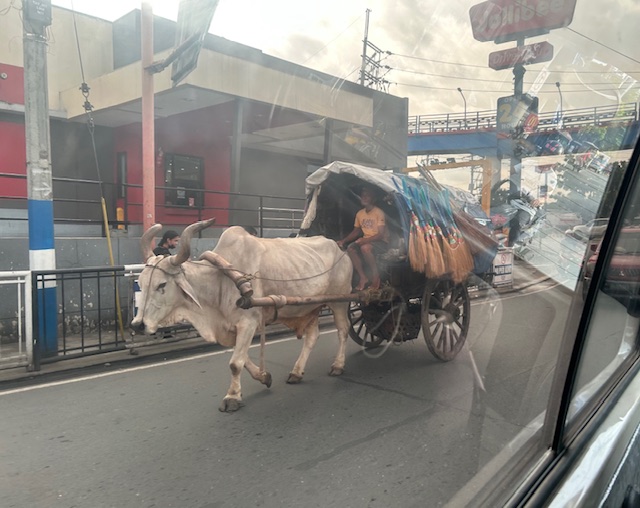 The cart was pulled by a bull that looked emaciated to me. I hope they’re able to feed this animal and care for it considering this is probably their most valuable asset.
While this seems like a spectacle these days, they were the mobile stores of the past; often traveling in groups. I wonder how long there will be animal-drawn carts like this.
–
On the need to rethink traffic metrics
While Level of Service (LOS) criteria is a concept that can be applied to many other transportation facilities and aspects, among the LOS criteria that have been the subject of much criticism (and perhaps rightfully so especially in the context of safety) are the ones used for intersections. These are associated with delay reduction, which always favors vehicular throughput. The latter means basically, high LOS corresponds to prioritizing car (or motor vehicle) movement while not particularly taking into consideration the safety and movement needs of other road users (not using motor vehicles). Here is an interesting article on this matter:
Boenau, A. (July 9, 2025) “The old traffic math that keeps destroying neighborhoods,” Fast Company, https://www.fastcompany.com/91362348/road-design-traffic-math-destroying-neighborhoods-los [Last accessed: 7/15/2025]
Quoting from the article:
Here are three important questions for experts to ponder:
- Is slow-moving car traffic ever safer than fast-moving traffic?
- Do we have any obligation to provide safe and convenient access for people when they aren’t inside cars?
- What are the economic downsides of wider, faster streets in the central business district?
When planners and engineers truly wrestle with those questions, they can choose to remain a conformist who ignores the damage of traffic metrics, or become an outlier in the industry and make a positive impact that might be felt for generations to come. Things can get better in the end.
–
Again, I must say that rethinking roads and streets should be context sensitive. Still, safety should be the top concern especially for areas that is predominantly residential and/or school. Safety, after all, comes first in the definitions of transportation and traffic engineering.
–
Quick comments on the NCAP
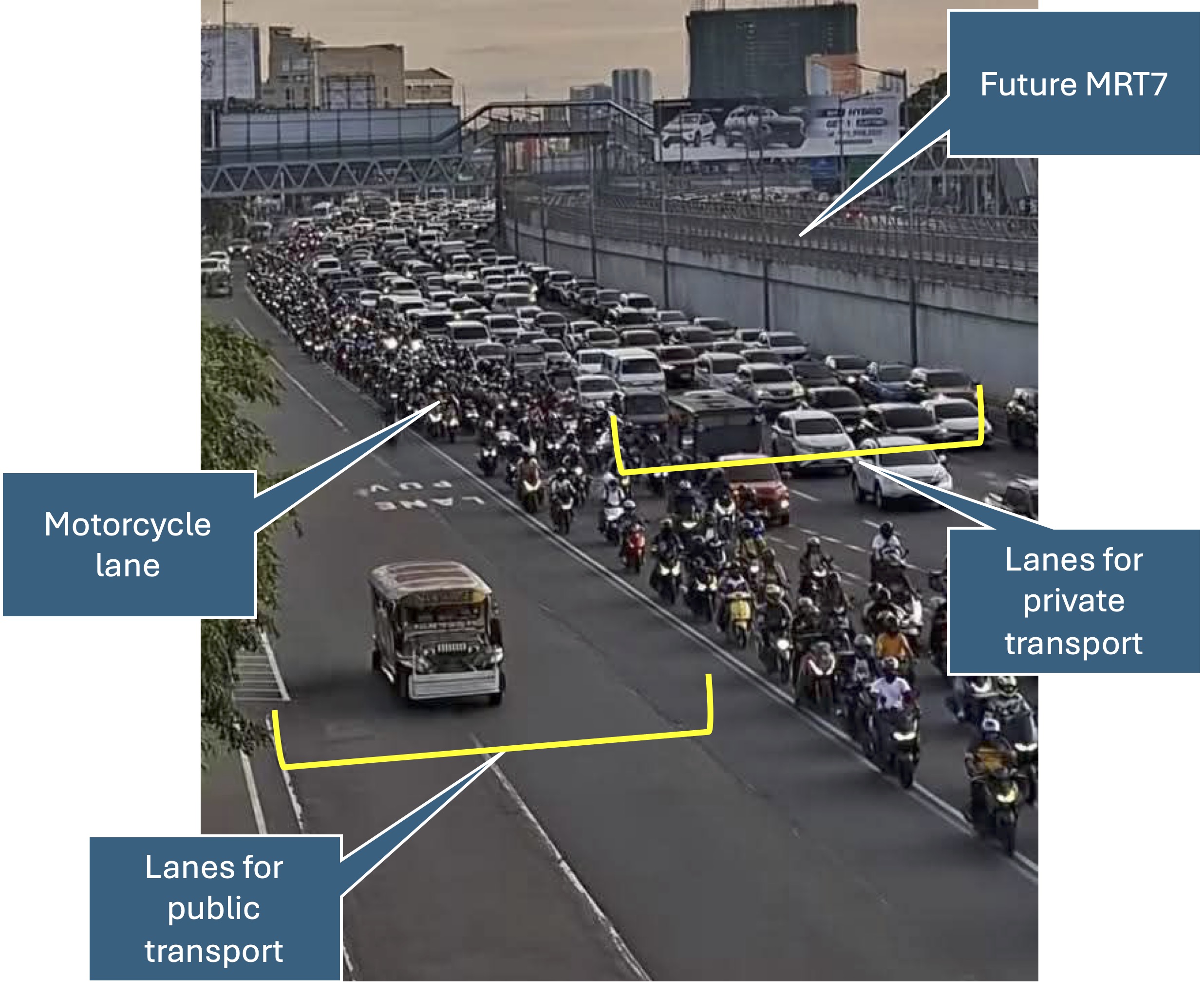
The No Contact Apprehension Policy (NCAP) is finally being implemented in Metro Manila. The results so far has been dramatic in terms of the number of violations recorded and the images being shared so far about how motorists are behaving. Below is one of those photos being shared on social media to which I added some annotations. I will use this later to comment on the NCAP and how we can use the outcomes to assess the transportation situation and determine what interventions can be done. Some are already obvious from the photo – the lack of public transport options lead to people depending on private motor vehicles like cars and motorcycles for their commutes. MRT7 is yet to be operational and road public transport has not been rationalized.
More on this topic soon!
–
Bollards along Marcos Highway
I noticed that there are new bollards installed along Marcos Highway and particularly along the curbs at either side of the road. These were installed only recently, perhaps last month, nut I only got a few photos the other day. Its not safe to take photos while one is driving so I asked the wife to take a few ones that I could use here and perhaps also in some of the lessons I teach.
 These bollards are installed along the curb where a couple of fatal crashes occurred in the past months.
The bollards are probably there to help improve road safety. They are reflectorized to you can’t miss them at night. Immediately behind them though are concrete barriers so hitting these will definitely damage the vehicle with a possibility of serious injuries to the vehicle occupants if not fatalities. Could there be a safer design intervention here? Perhaps that curbside lane can be converted into a protected bicycle lane. The barrier and the bike lane itself will be a buffer zone between motor vehicle traffic and active transport including pedestrians.
–
On the ‘silent walk’
My first post this May is an article share on what is referred to now as a ‘silent walk’. That means leaving your gadget at home or work to take walk whether in park, the city or your neighborhood. We all seem to be dependent on our gadgets these days, with many panicking when discovering they left their gadget. It’s as if their world has stopped without the gadget at hand.
Bull, M. (April 30, 2025) “The power of a “silent walk”,” Medium, https://blog.medium.com/the-power-of-a-silent-walk-93ffdd70dbcb [Last accessed: 02/05/2025]
To quote from the article:
“For many of us who rely on laptops, phones, and apps throughout the day, it can be easy to reach for those same devices when we need to relax — if they solve our productivity issues, the thinking goes, they must solve our stress, too. But just as spending the first hour of your day screen free will have an outsize effect on your inner peace, leaving the phone and headphone at home while you head out for a walk will return you to a saner place in record time.”
Granted that you bring your gadget for ’emergency purposes’, perhaps the key is not using it. Keep it in your pocket. Refrain from checking or glancing at the slightest temptation. It may be difficult at first but it will gradually build into your routine. And perhaps, too, you will feel a bit of liberation from these gadgets and reconnect with the world around you to help your well-being.
–
On step counts towards health and wellness
I’m sharing here an article about step counts. I guess the jury is still out there so to speak when it comes to the number of steps per day. The key is really to be active rather than just sit or lie down for most of the day. And there are many ways to be active and be able to measure it so you can monitor your movement.
Loudin, A. (February 28, 2025) “Why step count remains the most impactful fitness stat,” WebMD, https://www.webmd.com/fitness-exercise/news/20250228/why-step-count-remains-most-impactful-fitness-stat [Last accessed: 4/14/2025]
To quote from the article:
“For decades, the goal was 10,000 steps a day — but further research has shown that step counts as low as 2,500 still deliver long-term health benefits that increase as your step count rises — even past 10,000. The bottom line, however, is that more movement is better for you and serves as the best measurement of longevity.”
You can walk to start your day. You can walk in the middle of the day (say lunch time). And you can walk after dinner. And that’s just walking. Of course, you prefer to jog, run or bike, even swim, then that should do it for you in terms of being active. Walking though is really for most people who are physically able. And you can do it outdoors or indoors (yes, even in a building). So that’s where you should start in terms being more active towards health and welnness.
–
On walkable spaces for senior citizens
Here is a quick share of an article on walking and walkability, and the relation with dementia:
Steuteville, R. (March 10, 2025) “Living in a walkable place reduces dementia,” , https://www.cnu.org/publicsquare/2025/03/10/living-walkable-place-reduces-dementia [Last accessed: 3/29/2025]
To quote from the article:
“When we live in a walkable place, we move more, naturally. Unsurprisingly, exercise is linked to better cognitive health. Regular exercise increases memory, and boosts hippocampal volume by 2 percent.
Also, walkable neighborhoods are more stimulating. They are built on connected street networks, which give individuals more choices on how to get around and reward those choices with diverse physical paths linked to spatial memories. And they are mixed-use.
“Street layouts with better connectivity and walkability are associated with a reduced risk of cognitive impairment. Access to local amenities, such as food stores, community centers, and healthcare amenities, supports cognitive health,” the authors note.
Social connections also probably help. When you walk to a destination, you are more likely to have friendly interactions, which have been shown to reduce the risk of depression, and walkable places also boost the sense of community.”
As there are many senior citizens in our village, the topic is quite relevant. Most seniors probably won’t take a walk if they felt it was dangerous or risky even inside residential subdivisions. In our neighborhood, there are a few of them going around using their motorcycles or scooters. Most I see walking around perhaps for exercise or leisure rather than to go to a store or restaurant in the area. But increased traffic due to customers of restaurants that sprouted around the village has increased the risk for those who walk. Hopefully, the induced motor vehicle traffic generated by these establishments can be managed and regulated for the overall welfare of residents.
–
On the pushback vs. bike lanes
I saw this short article at Planetizen that linked to another article that was the original one about cities dismantling or removing bike lanes. This is a very concerning trend in the US but something that’s also happening here. The Department of Public Works and Highways (DPWH) has always been lukewarm to bike lanes (parang napipilitan lang), the Metro Manila Development Authority (MMDA) seemed never to understand it (even during BF’s time as Chair), and many local government units that jumped on the bike lane bandwagon during the COVID-19 pandemic have reneged on their declared commitments. Currently, it seems that only cities like Quezon City and Iloilo City have sustained bike lanes development. Others have removed protected bike lanes or have not enforced vs. motor vehicles encroaching on the bike lanes.
Johnson, R. (February 18, 2025) “Cities Start to Backpedal on Bike Lanes: A Growing Crisis for Cyclists,” Momentum Mag, https://momentummag.com/cities-start-to-backpedal-on-bike-lanes-a-growing-crisis-for-cyclists/ [Last accessed: 3/2/2025]
To quote from the article:
“Bike lanes have become a culture war where those in favor are seen as “woke” or some other terrible conservative slur. But, most who use bike lanes are just regular people who want to save some money, and get the mental and health benefits to cycling to work.
Urban cyclists, bike commuters, and advocates for safer streets, have all noticed a troubling trend. What was once a symbol of progress toward sustainable transportation and safer roads for all is being reversed in multiple cities across North America.”
Will bike lanes and cyclists suffer similar setbacks here? Will the Department of Transportation (DOTr) continue to champion bike lanes? Will the agency be more aggressive and assertive of bike lanes development? Your guess is as good as mine!
–
To B(RT) or not to B(RT)?
I kind of expected questions or comments from my ‘students’ after my lecture last Wednesday about “Traffic Congestion.” Among my slides were those featuring solutions to transport and traffic problems. I presented both soft and hard approaches including travel demand management schemes and infrastructure that we should have built decades ago. The uniformed officers who were there had a very simple take on congestion – it’s basically because of a lack of discipline. While theirs may also be valid observations based on their experiences, ‘discipline’ is not the most critical problem that we have especially considering the ever increasing demand for travel. One government official present was very direct in his question about what I thought about the MMDA’s pronouncement that they plan to remove the EDSA Bus Carousel. I thought my reply and the following explanation was clear – it was a wrong move.
The EDSA Bus Carousel is simple. Bus lang sa bus lane (Only buses along the bus lane). Pag may private or pa-VIP, bawal at huli dapat (If there are private vehicles or those who regard themselves as VIPs using the lane, then they should be apprehended. An HOV (high occupancy vehicle) lane is more difficult to implement. Mas pahirapan ang pag monitor and enforce (It is very difficult to monitor and enforce). So this proposal to phase out the EDSA bus lanes don’t make sense from this perspective. In fact, I don’t agree with a couple of more senior transport experts who say that the MRT Line 3 is sufficient and that it hadn’t reached capacity yet. It has but in the time that the carousel has been operational, the carousel had absorbed much of the demand along the corridor. There is also the fact that it will take much time before Line 3 is upgraded. Are the new train sets here? Are the stations designed for these trains and more passengers? If the answers are no, then MRT3 will not have its capacity increased in such a short time. That also means the carousel is very much relevant not just to supplement MRT3 capacity but as a needed alternative mode for commuters.
–
Tips for walking
I was at a clinic last week and found this special edition of a certain magazine that had meditation and mindfulness as the main themes. Walking was a topic of one article in the magazine and I got the following “tips” for walking:
- Walk when you wake up
- Walk to get lost
- Walk in the cold
- Walk in silence
- Walk after you eat
I will leave these tips as is for now and won’t be expounding on these. I will try to write about each in future posts. The reader is free to interpret or identify with these tips. I’m sure that many people will have experiences with at least one of the tips.
–
