
Home » EST (Page 3)
Category Archives: EST
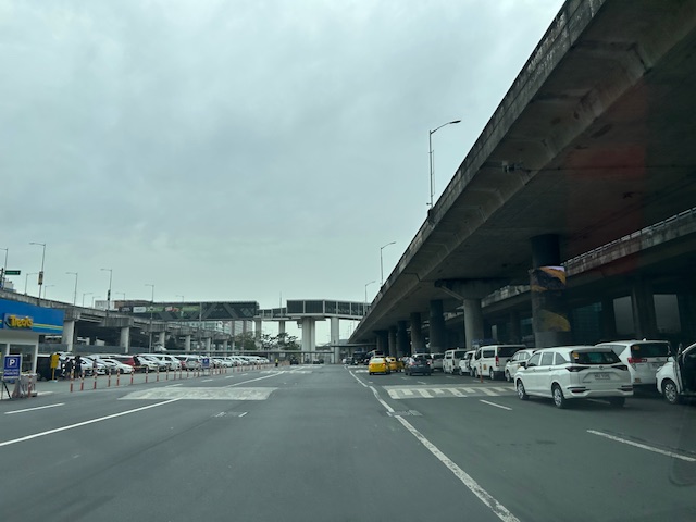
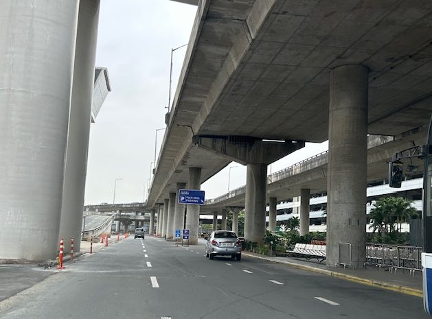
A suddenly spacious NAIA Terminal 3 outdoor parking area
The news of NAIA being taken over by San Miguel Corporation initially drew many criticisms. I won’t talk about these here but somewhat many things have changed aside from the airline assignments among the three remaining terminals. I said three because Terminal 4, what used to be the Manila Domestic Terminal, was already demolished. Among the changes are the suddenly spacious parking areas at the terminals. Here are some photos we took en route to the multi level parking prior to a trip.
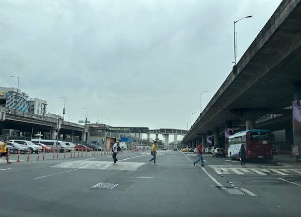 What used to be islands separating the Terminal 3 building from driveways and the open parking lot is no more.
 The area is suddenly very spacious allowing for more parking slots as well as a wide driveway for vehicles.
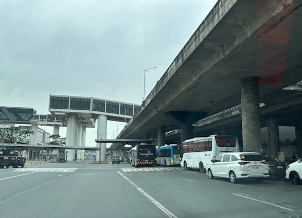 The buses also benefitted from the space as they can line up at the terminal stop without blocking other vehicles.
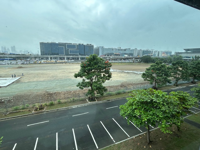
 The section leading to the multi-level parking building is not as congested. Most intending to park there including those leaving there vehicles for a few days enter via the upper level driveway. Rideshare vehicles generally use the ground level entrance.
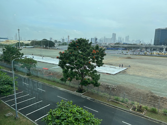 The graded open area that was just usually dirt or mud is now being paved. Perhaps this will provide additional parking spaces considering a significant part of the multi-level parking building has been committed to ride share and taxis.
 This used to be the area that was burned along with so many cars last year. Gone are the abandoned vehicles and perhaps these will all be paved. But was it necessary to just pave everything rather than have something porous and less heat generator than pavement? It would have been better to go for a multi-level facility and at the same time do some landscaping to have more trees and plants in this area.
–
To B(RT) or not to B(RT)?
I kind of expected questions or comments from my ‘students’ after my lecture last Wednesday about “Traffic Congestion.” Among my slides were those featuring solutions to transport and traffic problems. I presented both soft and hard approaches including travel demand management schemes and infrastructure that we should have built decades ago. The uniformed officers who were there had a very simple take on congestion – it’s basically because of a lack of discipline. While theirs may also be valid observations based on their experiences, ‘discipline’ is not the most critical problem that we have especially considering the ever increasing demand for travel. One government official present was very direct in his question about what I thought about the MMDA’s pronouncement that they plan to remove the EDSA Bus Carousel. I thought my reply and the following explanation was clear – it was a wrong move.
The EDSA Bus Carousel is simple. Bus lang sa bus lane (Only buses along the bus lane). Pag may private or pa-VIP, bawal at huli dapat (If there are private vehicles or those who regard themselves as VIPs using the lane, then they should be apprehended. An HOV (high occupancy vehicle) lane is more difficult to implement. Mas pahirapan ang pag monitor and enforce (It is very difficult to monitor and enforce). So this proposal to phase out the EDSA bus lanes don’t make sense from this perspective. In fact, I don’t agree with a couple of more senior transport experts who say that the MRT Line 3 is sufficient and that it hadn’t reached capacity yet. It has but in the time that the carousel has been operational, the carousel had absorbed much of the demand along the corridor. There is also the fact that it will take much time before Line 3 is upgraded. Are the new train sets here? Are the stations designed for these trains and more passengers? If the answers are no, then MRT3 will not have its capacity increased in such a short time. That also means the carousel is very much relevant not just to supplement MRT3 capacity but as a needed alternative mode for commuters.
–
Article share: On improving the Philippines’ transport system
I share this article on the desire for a sustainable transportation system for the country. This was written by a former Assistant Secretary of the Department of Transportation (on secondment) who has returned to teach at the School of Urban and Regional Planning of the University of the Philippines Diliman. Here is the article published by the Philippine Daily Inquirer:
To quote from the article:
“The present condition of the Philippine public transport system is indispensable to the desired transition from more sustainable, in this case, electric forms of transportation—to a better public transportation system. A good public transportation system is defined by reliability, accessibility, safety, and security…
The imperative to consolidate is clear and crucial. It is not just a technical necessity, but a pathway to inclusive growth where all stakeholders benefit from the transition, and where we can truly create an inclusive and sustainable system for public transportation.
Improving public transportation, by making it cleaner, safer, and more accessible, will directly enhance the quality of lives of Filipinos.”
–
Planning for True Transportation Affordability: Beyond Common Misconceptions
How much do we spend on transportation as part of our budgets? Is it 5% of your monthly budget? Is it 10%? Or is it eating up a substantial part of what you’re earning?
Source: Planning for True Transportation Affordability: Beyond Common Misconceptions
To quote from the article:
“This research indicates that many common policies favor expensive transportation and housing over lower-cost alternatives, which drives the cost of living beyond what is affordable, leaving too little money to purchase other necessities. The result is immiseration: growing stress, unhappiness, and discontent.
The solution is simple: planning should favor affordable over expensive modes and compact development over sprawl. This is not to suggest that automobile travel is bad and should be eliminated. Many people are justifiably proud of being able to afford a nice car, and automobiles are the most efficient option for some trips. However, automobile travel requires far more resources and is far more expensive than other modes, typically by an order of magnitude, so true affordability requires an efficient, multimodal transportation system that allows travelers to choose the options that truly reflect their needs and preferences.
Affordability requires a new economic paradigm; rather than trying to increase incomes or subsidies we need to increase affordability and efficiency so households can satisfy their basic needs consuming fewer resources and spending less money. Our planning should be guided by a new goal: how can we help families be poor but happy.”
I share this article because it provides a more complete narrative and assessment than those just focusing on transport. Home choice locations and affordable housing are part of the equation. Looking at transport alone can be myopic and leads us to think it is the only problem to solve.
–
Are transportation issues election issues in the Philippines?
Are transportation issues in the Philippines? Or are these issues at the local level? Here is an article about how transportation issues were brought to light and were actual topics in the ballot in Los Angele, California in the US:
Tu, M. (November 25, 2024 ) “Bike, Bus and Pedestrian Improvements Won the Vote in L.A. How Did Advocates Pull It Off? “ Next City, https://nextcity.org/urbanist-news/bike-bus-pedestrian-improvements-healthy-streets-los-angeles-ballot?utm_source=Next+City+Newsletter&utm_campaign=532838ef65-DailyNL_2024_11_18_COPY_01&utm_medium=email&utm_term=0_fcee5bf7a0-532838ef65-44383929 [Last accessed: 11/26/2024]
The three lessons in the article are:
- Build a coalition – “In the lead-up to the election in March, Streets For All successfully secured endorsements from unions, climate organizations and business groups that saw the vision for safer streets.”
- Safety wins – “We could make climate arguments, we could make equity arguments, but the thing that felt the most bulletproof to us and the most empathetic to the general Angeleno was just road safety,”
- Keep it simple – “…simple messages were the most effective. Vredevoogd fought for one billboard on Vermont Avenue that read “In 2022, more pedestrians died on Vermont Avenue than in the state of Vermont.”
Los Angeles or LA as many people fondly call the city is well known for being car-centric (as opposed to San Francisco to the north, which is more transit-oriented). Perhaps we can learn from this experience though I know there are already groups and coalitions lobbying for better transportation in the Philippines. Are they successful and to what extent are they succeeding? Granted there are different situations and conditions, even modalities, to engage politicians, there are also so-called party list groups claiming to represent the transport sector but none appear to be really standing up for issues like improving public transport or road safety. And so the challenge is still there for people to make transportation issues election issues in the country.
–
On the general benefits of public transportation
Here’s another good read that has links to the outcomes of studies pertaining to public transportation’s direct and indirect effects on vehicle miles traveled or VMT (in our case we use vehicle kilometers traveled or VKT):
McCahill, C. (November 12, 2024) “The benefits of transit extend well beyond transit riders,” State Smart Transportation Initiative, https://ssti.us/2024/11/12/the-benefits-of-transit-extend-well-beyond-transit-riders/ [Last accessed: 11/20/2024]
To quote from the article:
“…good transit has a ripple effect on land use and travel behavior. For every mile not driven by transit riders, transit accounts for another six to nine miles not driven among the larger population. “
Note the potential reduction in VKT’s attributed to mass transportation or transit.
–
How the Built Environment Affects Your Mood
Here’s a nice read as we do our storm watch, and probably explains why when we reminisce about college or university as “the best years of our lives”.
Source: How the Built Environment Affects Your Mood
To quote from the article:
“It is not for nothing that older adults often regard college as “the best years of your life” because in some cases it truly is. College years serve as a gateway drug to all the amenities and benefits of urban-core living — until you graduate that is. Then you have to return to your parents’ suburban home (as many Americans do) and suddenly all the amenities you had disappear. Your newfound college friends might make up for the lack of a diverse built environment. Nope, they all have moved back to their sprawling neighborhoods too, probably dozens of miles if not hundreds of miles away from your town. You might get a new car to celebrate your graduation and your new 9 to 5 corporate job. Work will keep you busy! But you know what else? Driving. No more waking up 10 minutes before class and arriving just on time. You might now have to wake up a few hours early to drive to your job through rush hour morning traffic, and do it all again in the afternoon.
You might also gain weight — not because you are eating more, but because you are walking less. Various studies demonstrate the link between car usage and obesity, showing “greater levels of obesity in communities where the private automobile is the dominant means of transportation.” And let’s not forget that obesity leads to other health issues such as diabetes and hypertension, among others. Mental health conditions such as depression are more prevalent in adults with obesity. Hence once college ends, graduates stop socializing, stop enjoying public amenities every day, start driving everywhere, stop walking and hence gain a little more weight in the process. Then it is no surprise that young graduates feel unfulfilled, and sometimes even depressed after college — for them, it feels they were robbed of an integral part of their new lives.
Our surroundings impact our mental and physical health. Living in neighborhoods with negative qualities can increase the risk of mental health conditions such as depression. At the same time, the pandemic made us appreciate diversity in our lives and what happens when we are deprived of it. Walkable cities are not “just a preference”; they develop happiness by fostering community trust, promoting physical activity, and offering nearby amenities. As learned, these spaces encourage healthy behaviors, reduce car dependency, and create opportunities for social interaction — all things that are crucial for our well-being.”
Based on this, no wonder I love to stay at the University of the Philippines campus in Diliman. I’m sure my colleagues in UP Los Banos feel similarly.
–
On whether bike lanes cause more traffic congestion
I previously share articles on whether bike lanes cause more traffic. This question has been asked so often as we have returned to the “old normal” levels of traffic and bike lanes that were put up during the pandemic have been neglected or removed in favor of motor vehicle traffic. The perception for those in-charge of traffic and transportation in local government units is that the space occupied by bike lanes take up the space demanded by motor vehicle use. Thus, the view that bike lanes cause congestion. Here is another article share in support of bike lanes:
Mortillaro, N. (October, 2024) “Do bike lanes really cause more traffic congestion? Here’s what the research says,” cbc.ca, https://www.cbc.ca/news/science/bike-lanes-impacts-1.7358319 [Last accessed: 01/11/2024]
To quote from the article:
“One would think that building more roads with more lanes for cars would reduce congestion, but research shows that’s not the case, thanks to something called induced demand. The more traffic lanes that are put in, the more it appeals to people who may not otherwise have chosen to drive, thereby putting more cars on the roads and increasing congestion.
“So for a short period of time, there might be a slightly improved [reduction], but within a year or two, or perhaps three, traffic is as bad or worse than it was before the lanes were added in the first place,” said David Beitel, data services lead at Eco-Counter, a Montreal company that collects and analyzes pedestrian and bicycle traffic data.
Conversely, if you put in more dedicated bike lanes, people tend to feel safer and demand for use increases, said Shoshanna Saxe, an associate professor at the University of Toronto’s department of civil and mineral engineering and Canada Research Chair in sustainable infrastructure.
“As soon as you build a bike lane, within a year, two years, the latent demand shows up,” she said.
Bike Share Toronto statistics show that ridership on its network of shared bikes has increased dramatically since 2015, when 665,000 bike trips were made annually. In 2023, that shot up to 5.7 million trips.”
I think many people here are already aware of the concept of induced demand. However, this is usually shrugged aside as realities in their situations (e.g., commuting options, locations of residences and workplaces, etc.) lead them to choosing private vehicles (i.e., cars and motorcycles) over public or active transport. The last paragraph there is significant though as there never was and so far a decent estimate of bike trips in any city in the Philippines. Granted that there are attempts to measure bike trips but the volumes published so far are not as reliable as we want them to be in order to be convincing decision-makers to put up more bike lanes. Of course, the convincing part is always challenging if decision-makers have already made up their minds in favor of the car.
–
On transportation and global health – article share
I was supposed to write about the keynote lecture delivered during the 30th Annual Conference of the Transportation Science Society of the Philippines (TSSP). I am sharing instead an article written by Dr. Renzo Guinto who is an Associate Professor at the SingHealth Duke-NUS Global Health Institute based at the National University of Singapore.
Here is the link to his article on the Philippine Daily Inquirer: Health at the center of transport and mobility
I will not quote from the article and leave it to my readers to read and appreciate the articles content.
–
On ride hailing replacing more sustainable options for transport
We’ve long suspected that ride hailing or ride sharing is not as sustainable as their proponents and companies would project them to be. Here is more evidence showing how ride hailing has diminished other more sustainable transport options.
Kerlin, K. (August 28, 2024) “Half of Uber, Lyft Trips Replace More Sustainable Options,” UC Davis News, https://www.ucdavis.edu/news/half-uber-lyft-trips-replace-more-sustainable-options [Last accessed: 9/8/2024]
Quoting from the article:
“About 47% of the trips replaced a public transit, carpool, walking or cycling trip. An additional 5.8% of trips represented “induced travel,” meaning the person would not have made the trip were an Uber or Lyft unavailable. This suggests ride-hailing often tends to replace most sustainable transportation modes and leads to additional vehicle miles traveled. “
The article and the study by UC Davis is limited to their experiences with Uber and Lyft and perhaps others that employ cars. In our case, we have in addition motorcycle taxis or habal-habal that further takes away passengers from public and active transportation. Motorcycle taxis provide a very attractive alternative to conventional public transport modes as these are perceived to reduce travel times among other advantages they provide to users.
I will share some information later about the current mode shares in Metro Manila and how drastically public transport mode shares have been eroded post pandemic.
–
