
Home » Governance (Page 41)
Category Archives: Governance
National Budget Memo No. 118
The Department of Budget and Management recently released the National Budget Memo No. 118 with the subject: Adoption of the Budget Priorities Framework in the Preparation of the FY 2014 Agency Budget Proposals. The Memo emphasizes “the need to prioritize the programs critical to the attainment of the desired outcomes for the 2014-2016 period.” In addition to the bottom-up budgeting (BUB) approach, the memo identified priority geographical areas for program convergence for the 2014 budget. It is important to note the focus of the government on inclusive growth and the convergence programs for infrastructure to support industry, agriculture and tourism, as well as significant mention of climate and disaster resilience for programs to be implemented by the government. Following is a link to the DBM site where a PDF copy of the memo can be downloaded:
DBM National Budget Memorandum No. 118
I’ve downloaded a copy and this may be downloaded here:
–
Poverty Statistics in the Philippines
The National Statistical Coordination Board (NSCB) of the Philippines recently released poverty statistics as of the first semester of 2012. The report is based on the outcomes of the Family Income and Expenditure Survey (FIES) conducted by the National Statistics Office (NSO) in July 2012. Both agencies are under the National Economic Development Authority (NEDA). The stats on poverty incidence are shown in the following link:
In relation to these poverty figures, the NEDA Director General Arsenio Balisacan issued the following statement:
STATEMENT OF SEC. BALISACAN AT THE PRESS CONFERENCE ON THE 2012 FIRST SEMESTER POVERTY STATISTICS
I am curious to see how much of family expenditures go to transport. Clearly, the state of the country’s transportation system is a significant factor in development and the government’s initiatives towards inclusive growth will not prosper if we continue to have inefficient transport across all modes for both people and goods.
UP Village transformation
UP Teachers Village in Quezon City is a good example of a residential area that has been transformed over a few years. This transformation was enabled mainly by its streets, particularly Maginhawa Street, being open to general traffic. Teachers Village roads are often used as short cuts between major roads like Commonwealth Avenue and C-5/Katipunan (via C.P. Garcia Street), and Elliptical Avenue, Kalayaan Avenue and V. Luna. Due to both significant foot and vehicle traffic, what used to be homes along the streets have become restaurants, shops, offices, or even schools. There are many cases of homeowners who have found their houses less livable due to the noise and air pollution attributed to traffic (Note: There are so many tricycles in the area.). These have sold their property to people who used it instead for business. Unfortunately, despite the approval of the local government of the changes in land use, most establishments clearly have not satisfied basic building code requirements such as those for parking and pedestrian facilities.
 On-street parking along both sides of Maginhawa Street in Teachers Village
 Schools and commercial establishments like restaurants and shops are found along Maginhawa Street. Most do not have adequate parking spaces for customers.
Maginhawa Street has been widened to accommodate more vehicular traffic. Unfortunately, widening the road has only led to more on-street parking as shown in the preceding photos. People also are often forced to walk along the carriageway because because sidewalks are usually blocked, with some establishments using the space for al frresco set-ups. Developments need to be inspected to check if they comply with basic requirements such as parking and pedestrian facilities. Development and land use changes can be justified but proponents must be made to comply with the minimum requirements of the National Building Code in order to mitigate potential impacts to the community.
–
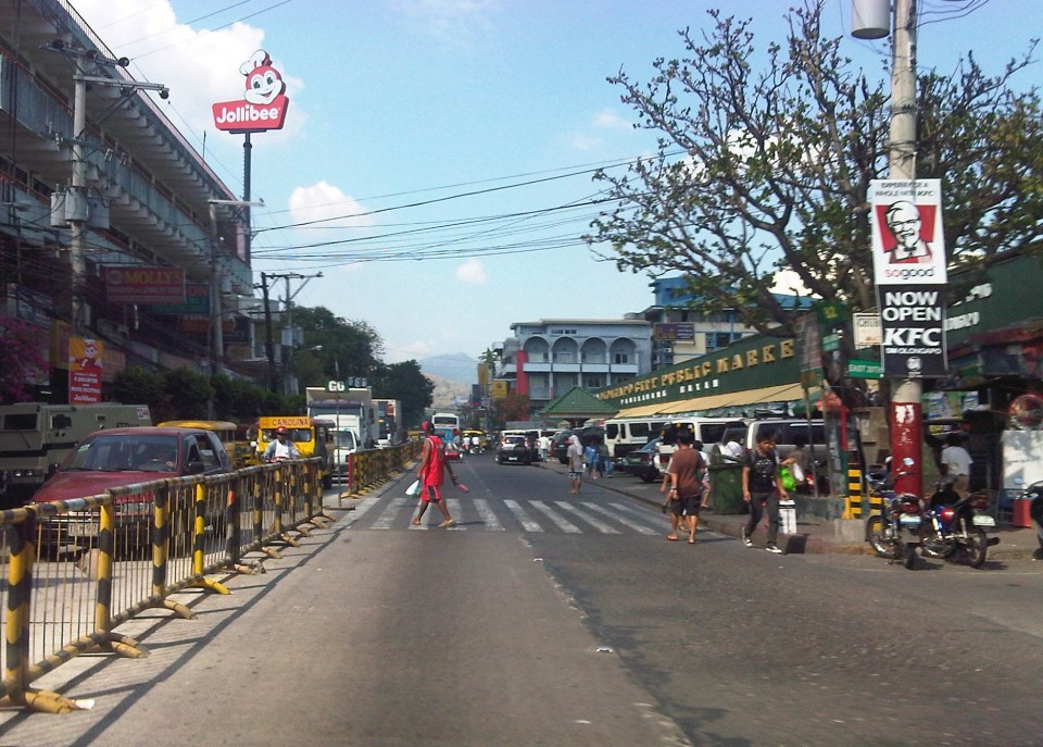
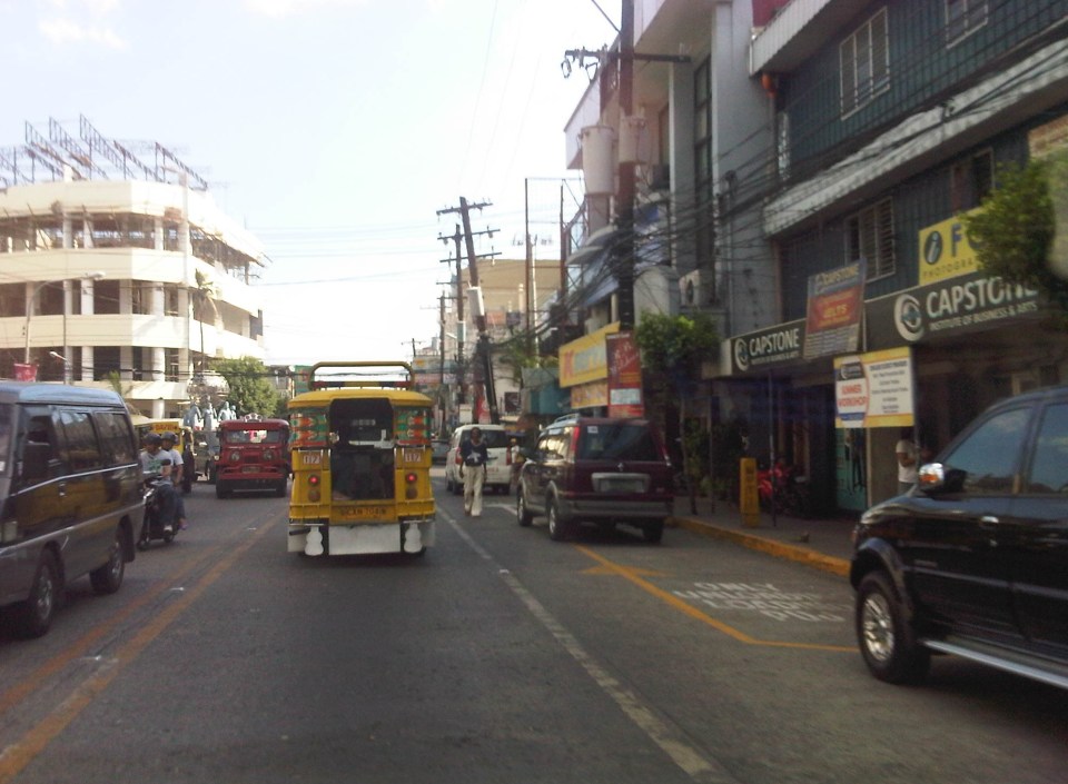
Streets of Olongapo: Rizal Avenue
Olongapo City is located in the Province of Zambales, the only city in that province, and beside the Subic Freeport. It is a pioneer in public transport service innovations in the form of the first initiative on the color-coding of jeepneys according to their routes. Despite what seemed to be forever being linked to the Freeport in terms of economic development, the city has enjoyed continued growth and is currently experiencing more challenges attributed to this growth. Among these challenges are those pertaining to traffic congestion and public transport services for the city. A Transportation and Traffic Management Plan Study was conducted by UP Diliman through the National Center for Transportation Studies and is up for formal adoption of the city.
Following are photos taken along the city’s main street, Rizal Avenue, where many of the city’s transport and traffic problems are manifested.
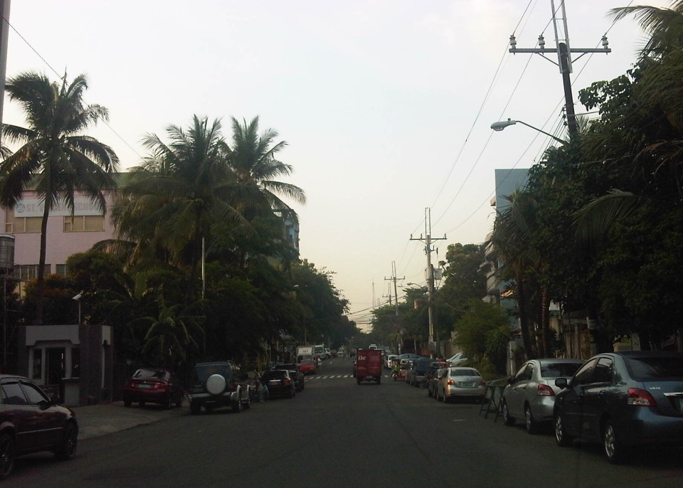
 Cyclist pedaling along Rizal Avenue beside a yellow jeepney taking passengers at the designated stop at curbside. Downstream are parked vehicles along the road.
 More parked vehicles at either side of Rizal Avenue effectively reducing road capacity for the 4-lane street.
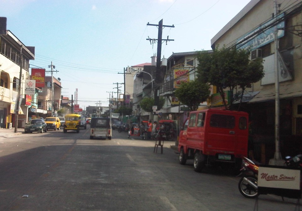
 On-street parking is a problem for the city as there are few, if any, off-street parking facilities in the city. On-street parking turnover is quite low since many of the parked vehicles are not clients or customers but establishment owners or managers.
 Most of Rizal Avenue is undivided but there are median barriers along the section in front of the public market to reduce jaywalking among pedestrians.
 The section in front of city hall – just across are many commercial establishments and on-street parking.
 Another view of the Rizal Avenue, this time along the westbound side, with the the market on the left side. The yellow jeepneys are quite conspicuous and remind me of the UP Ikot jeepneys.
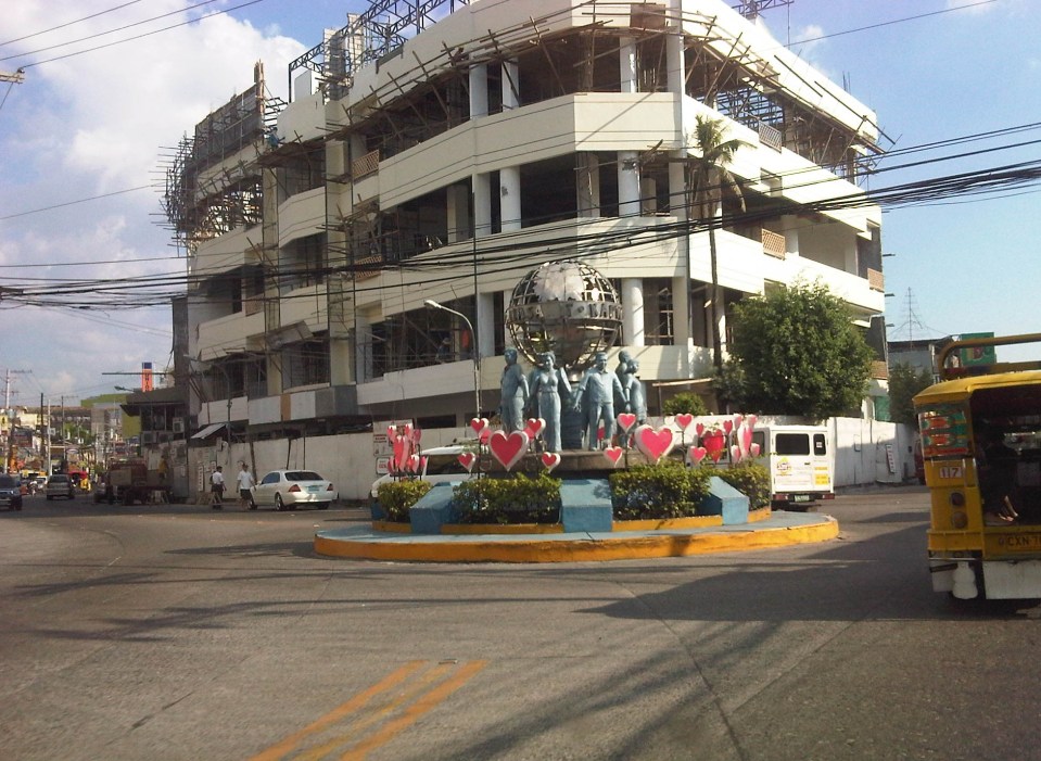
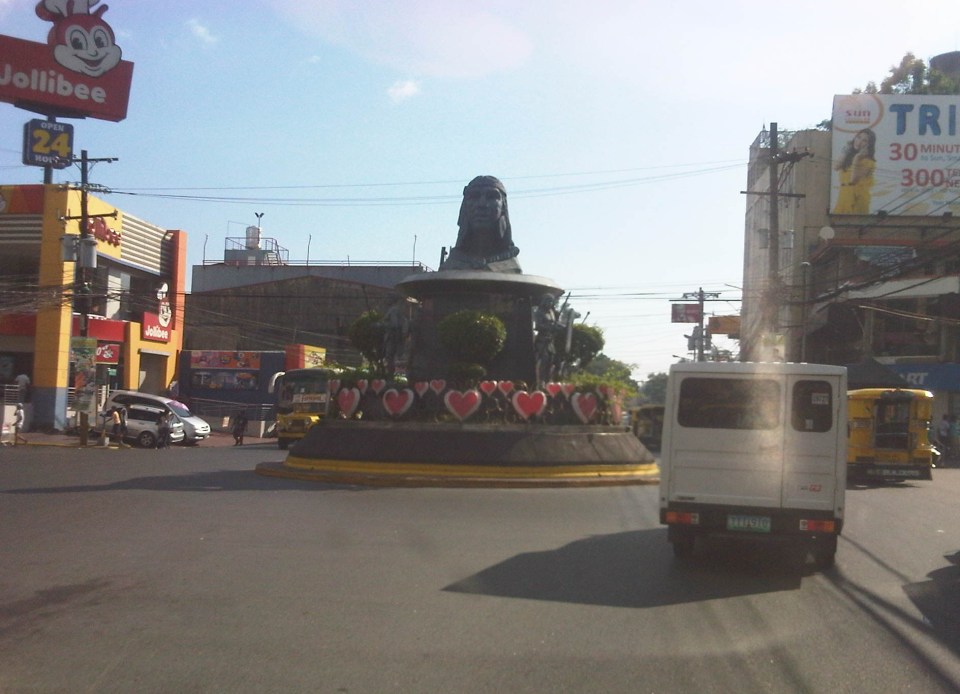 A monument to the Ulo ng Apo, from which the name of the city is said to be derived from, is right in the middle of a rotunda at a major intersection along Rizal Avenue. Around the rotunda are commercial establishments and a major provincial bus terminal.
 There are designated stops for jeepneys along the avenue but these are often crowded out by parked vehicles. As a result, jeepneys could not maneuver properly and end up unloading/loading passengers in the middle of the road.
 On-street parking along curves tend to impede the flow of traffic. There are also issues where electric posts like the one shown in the photo have not been transferred, posing risks to vehicular traffic.
 Another example of a designated jeepney stop along the avenue where parked vehicles constrict maneuvering space for jeepneys.
 A monument to the volunteers of Olongapo during the Mt. Pinatubo episode after the closure of the U.S. Naval Base in what is now a Freeport. I wonder if the building under construction in the photo has enough parking spaces for the traffic it generates.
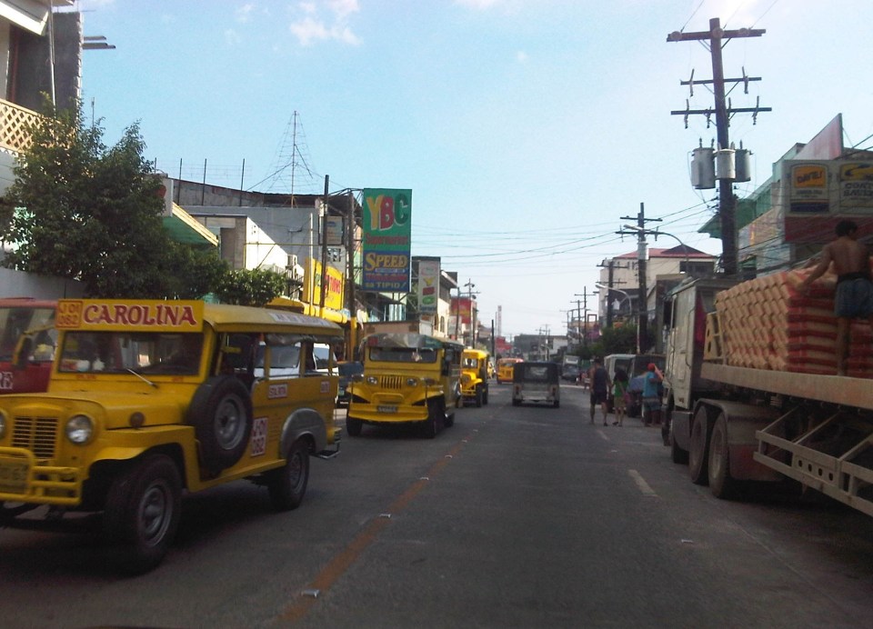 More jeepneys and more on-street parking – there is a perception that there are too many (oversupply) of jeepneys. Note though that most PUJs in Olongapo are not the bigger 20 to 24 seater jeepneys we see in Metro Manila but the older, 16 to 18 seaters like the ones shown in the photo.
 Some on-street parking spaces are “reserved” by establishments. I didn’t mention that on-street parking is free of charge and such situation probably encourages longer parking durations. Perhaps the city should seriously consider parking fees to reduce long-term parking and ensure smoother flow of traffic along its streets. There are examples of these parking schemes in other cities including Makati City that Olongapo can adopt and adjust.
–
The Economic Case for Rail Subsidies
Today, I’m sharing a nice article on rail subsidies from The Atlantic Cities:
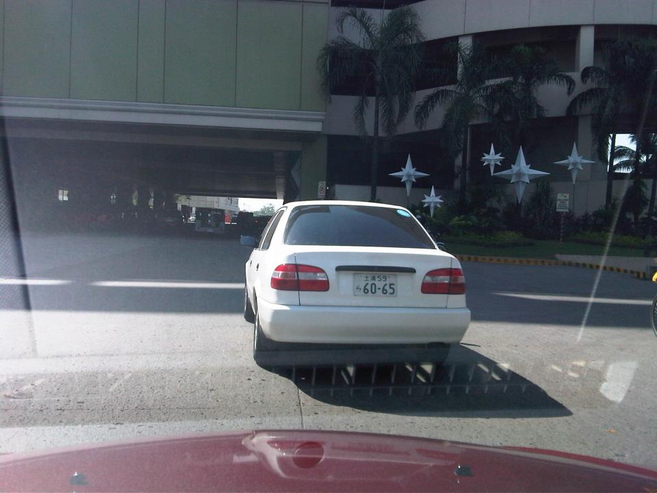
On license plates
More than 2 years ago, the current administration made an inspired move after the President mentioned in his inaugural speech that he was among those who didn’t like “wangwang” (sirens) and associated these with abusiveness, of feelings of entitlement among road users. The use of sirens and other similar devices tells people that the user is an “important” person whose time is more valuable than others.
Whatever happened to the drive against “wangwang” in all its forms? The proliferation of commemorative plates, for one, can be a form of “wangwang.” While the Land Transportation Office (LTO) came up with a memo a few years ago providing clear instructions on how the commemorative plate should be displayed (i.e., on top or above the legal plate), many have returned to the practice of replacing the license plate (hiding it) with the commemorative one. This is especially true for those plates bearing police, military, government, and other agencies or organizations that can be used to make traffic enforcers think twice about apprehending a motorist for legitimate traffic violations. One sees such plates everywhere screaming “PNP,” “CIDG,” “NBI,” “PMA,” “Prosecutor,” “Councilor,” etc. and you know these are statements that are meant to intimidate traffic enforcers, which is often denied by the guilty party.
Then there is also the abuse of special plates, particularly those supposedly assigned to lawmakers. How many people have “8” as their license plates? Do children or staff of senators and congressmen enjoy the same privileges as the elected official? In the past, plates bearing “8” also indicated the district represented by the person supposedly using the vehicle. And so you would know, for example, if the person happens to be from the 1st District of Iloilo or the 3rd District of Quezon City. The same goes for vehicles bearing “16” and other special plates indicating someone holding a high position in government. Nowadays, even family members and staff members of these officials use the special plates, thereby extending to them the courtesies usually given to elected or appointed officials like not being covered by the number coding scheme in Metro Manila. This should not be the case for such “extensions” if we are to enforce the law firmly and fairly.
In certain cases, worse are those who use neither license plates or authorized commemorative ones. There seems to be a proliferation of people using personalized, souvenir or replica plates from other countries. These are often used in lieu of the rear license plates. These are claimed to be harmless since traffic enforcers usually check only the front plates for registration and compliance to number coding. However, there are implications for when the driver and the vehicle are involved in incidents such as traffic violations or crashes (e.g., hit and run incidents). While witnesses would probably be able to describe the car, the license plate cannot be recorded. Therefore, it would be quite difficult to trace the vehicle’s ownership information that could be retrieved from the LTO’s computer records to identify the violator or suspect in an incident.
 The legal plate is deliberately obscured on this one as it is hidden in the rear bumper.
 The plate suggests one is driving in Europe rather than along C-5 somewhere in Pasig City
 This one thinks he’s driving in Japan.
Perhaps the LTO and traffic enforcers who are deputized by the agency should also clamp down on these cases of violating RA 4136. The idea is to have a campaign similar to what was implemented to rid our roads of the annoying “wangwang” back in 2010. Such an initiative should help promote discipline on our roads in the sense that motorists would be more aware of traffic rules and regulations and that they cannot continue trying to circumvent basic laws.
–
Rationalizing public transport in the Philippines
I got a copy of the recent study “Development of a Mega Manila Public Transportation Planning Support System” conducted by UP Diliman’s National Center for Transportation Studies (NCTS) for the Department of Transportation and Communications (DOTC). The main outcome of the study was a planning support system that includes an updated database of bus, jeepney and UV Express routes for Metro Manila and its surrounding areas (collectively called Mega Manila), and a calibrated travel demand model for the region that is supposed to be used by the DOTC and the LTFRB in transport planning including the rationalization of public transport in the region. Among the notable recommendations for addressing public transport issues is the following on the classification of routes according to passenger demand, which I quote from the study:
“…routes and modes may be classified and prioritized as follows:
- Routes with Very High Passenger Demand [>160,000 passengers per day] – shall be served by high capacity modes such as rail-based transit or Bus Rapid Transit(BRT) with passing lanes.
- Routes with High Passenger Demand [100,000 to 160,000 passengers per day] – shall be served by high capacity vehicles such as Bus Rapid Transit System (BRT) without passing lanes;
- Routes with Medium Passenger Demand [10,000 to 100,000 passengers per day] – shall be served by PUVs with 60 or less passengers/seats but not less than 22 passengers (excluding driver) such as buses, CLRVs with more than 22 passengers/seats (including driver), or with 90 passengers/seats in the case of double decker or articulated buses;
- Routes with Low Passenger Demand [not exceeding 10,000 passengers per day] – shall be served by PUVs with less than 22 passengers/seats (including driver) such as jeepneys and other paratransit modes.
Under this principle, high capacity modes would have priority in terms of CPC allocation and transit right of way in a particular route over lower capacity modes with the exception of taxis. The latter, after all, operate as private cars rather than PUVs with fixed routes.
Applications to operate bus and/or minibus service in jeepney routes can be considered, but not the other way around. Similarly, bus service applications can be considered in minibus routes but not otherwise.
Based on the analysis of routes, the establishment of public transportation routes and the corresponding modes of services may be based on the following criteria:
• Passenger demand patterns and characteristics
• Road network configuration
• Corresponding road functions (road hierarchy)
• Traffic capacities and
• Reasonable profits for operation of at most 13% ROI.”
[Source: DOTC (2012) Development of a Mega Manila Public Transportation Planning Support System, Final Report.]
An interesting figure in the report is an illustration of how services can be simplified using buses and rail transport as an example. The following figure shows two maps: one showing the plotted EDSA bus routes (left) and another showing a more consolidated (and rational) route network for buses complementing existing and proposed rail mass transit systems.
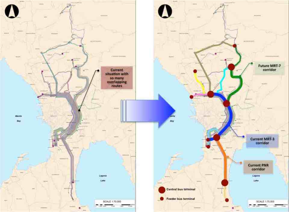 Simplifying bus transport services (source: DOTC, 2012)
What are not included in the figure above are the prospects for Bus Rapid Transit (BRT) systems for Metro Manila. Since the Final Report was submitted in mid 2012, there have been many discussions for BRT in the metropolis and current efforts are now focused on the assessment of a BRT line along Ortigas Avenue. The World Bank is supporting the evaluation of a route between Tikling Junction near the boundary of Antipolo and Taytay (Rizal Province) and Aurora Boulevard. There are also informal talks of a BRT line along Commonwealth Avenue but that would have implications on the proposed MRT-7 along the same corridor. Nevertheless, such mass transit systems have long been required for Metro Manila and their construction have been overdue. A more efficient public transport system will definitely have tremendous impacts on how we commute between our homes, workplaces, schools and other destinations. Long distances can easily be addressed by better transport options and could actually help solve issues pertaining to informal settlements, relocations and housing. That topic, of course, deserves an article devoted to this relationship between transport and housing. Abangan!
–
Loss of productivity due to congestion and inefficient public transport
I recently read two articles appearing in a major Philippine daily and a popular online site. The first one is an article that appeared in the Philippine Daily Inquirer – “PH economy losing $3.27B in human productivity due to traffic mess” – last September 25, 2012. The other article was posted on Rappler – “Traffic and infrastructure delays cost the Philippines” – last September 27, 2012. These were articles written after the authors’ attendance of what was an Energy and Infrastructure Forum last Sept. 25 where a transport official mentioned a recent study in his talk that estimates productivity losses of about 3.27B USD per year from Metro Manila traffic alone.
 Traffic congestion along Commonwealth Avenue
 Unusual traffic management scheme along Ortigas Avenue
The study from the National Center for Transportation Studies that was mentioned in both articles was actually first featured in a Yahoo! Philippines article – “Traffic congestion costs Metro Manila P137B per year” – that appeared a month earlier in Aug. 28, 2012. The study being referred to is actually a paper presented by Dr. Jose Regin F. Regidor in his Professorial Chair lecture at the University of the Philippines Diliman’s College of Engineering Colloquium in early August 2012. A copy of the paper may be found below:
Prof Chair 2012 JRFR 02July2012
The main reference for this paper is the study on congestion costs that was produced by the National Center for Transportation Studies back in 2000. Credits go to the core team of Dr. Ricardo Sigua (Institute of Civil Engineering of UP Diliman), Dr. Noriel Tiglao (now with the National College of Public Administration and Governance) and Dr. Val Teodoro (now in the US) for the study. The
Economic Impacts of Traffic Congestion in Metro Manila – Cover+Chap 1 and 2
Economic Impacts of Traffic Congestion in Metro Manila – Chap 3
Economic Impacts of Traffic Congestion in Metro Manila – Chap 4 and 5
Economic Impacts of Traffic Congestion in Metro Manila – Appendix
A much needed update may be possible in the next two years once the traffic model for Metro Manila is updated and calibrated using new data from Household Informations Surveys (HIS) and other transport and traffic surveys under the current MUCEP study that is supported by the Japan International Cooperation Agency (JICA). Hopefully, such a model can be updated and calibrated more often in order to assess losses due to congestion and our continuing inability to provide the necessary infrastructure to alleviate the situation. While the paper and the study mentioned above focus on productivity losses, it should be emphasized that there are other costs that should be highlighted including those related to health (respiratory diseases and road crash fatalities and injuries), energy (fuel consumption and inefficiencies), and emissions (carbon and other GHG).
–
Davao’s Traffic Management Center
I finally had the opportunity to visit Davao City’ Traffic Management Center, a modern facility that serves as a command center for traffic management as well as for disaster response for what is arguably the largest city in terms of land area in the Philippines. The city is able to monitor traffic via CCTVs installed throughout its road network, particularly at intersections. This allows the city to also respond to incidents like road crashes and to call in police or emergency personnel for various concerns. Traffic signals are also controlled from this facility. Our visit to Davao was upon the invitation of the City Mayor, Hon. Sara Duterte, and we had a meeting with the City Planning and Development Coordinator, Mr. Roby Alabado, who was a faculty member of UP Mindanao and a very active public servant. With me was Dr. Ric Sigua, Professor at UP Diliman’s Institute of Civil Engineering and the current head of the Road Safety Research Laboratory of National Center for Transportation Studies.
 This is a view of the control center screen (actually comprised of several LCD screens) from the conference room of the TMC. Normally, there is a curtain screen covering the glass wall that they can raise in order to give people a view of the video screens.
 Each screen can be made to show conditions at different locations and staff can control the camera view from the command center. This control allows them to pan, zoom and just about see what goes about at different locations in the city.
 Cameras installed around the city are high definition and can focus and provide clear shots of license plates.
 Close-up of a taxi among other videos of areas being monitored. Cameras can also focus on particular people such as a driver trying to bribe himself out of a traffic ticket.
 Videos, particularly those of incidents, are recorded and archived for future reference including reviews related to road crash investigations. Streets are well-lighted to allow for clear capture of incidents at night. In the photo, a truck is observed hitting a jeepney from the rear at an intersection with light traffic.
 The aftermath of a road crash incident involving a truck and a jeepney shows the latter on its side.
 Dr. Sigua being briefed by TMC staff about their capabilities.
 Dr. Sigua with Davao’s Mr. Roby Alabado (City Planning and Development Coordinator) and Mr. Dick Coridel (OIC of Traffic Management Center).
Major cities in the Philippines should have similar facilities for traffic monitoring and management that could also be employed for other purposes as well. The latter may include incident detection, response and management such as emergency response for medical, fire or even security-related incidents. So far, I do know that Metro Manila has two such centers – one with the MMDA and another with Makati City. Cebu has one but it badly needs upgrading including the acquisition of CCTV cameras as they prepare to also upgrade their traffic signal system that was once the most sophisticated in the country.
–
Transportation-related lectures at the UP College of Engineering 2012 Professorial Chair Colloquium
The College of Engineering of the University of the Philippines Diliman will be holding its Professorial Chair Colloquium for 2012 on July 30, 2012 at the Melchor Hall and the UP Alumni Engineers Centennial Hall at the UP Diliman campus. Among the topics under many disciplines of engineering are several lectures on transportation. These are the following and mainly under three departments of the college.
Institute of Civil Engineering [P & G Room, Melchor Hall]
- “Investigation of Road Crash Causes in Metro Manila,” Dr. Hilario Sean O. Palmiano, DMCI Developers Professorial Chair [8:30 – 8:50 am]
- “Design of Traffic Signal Timing and Traffic Impacts of the Re-introduction of Traffic Signal Control at the Intersection of the University Avenue and Commonwealth Avenue,” Dr. Karl B.N. Vergel, Maynilad Professorial Chair [8:50 – 9:10 am]
- “Microscopic Simulation: A Tool for Evaluation of Traffic Schemes,” Dr. Ricardo G. Sigua, Prof. Emeritus Norbert S. Vila Professorial Chair [9:10 – 9:30 am]
- “Revisiting the Costs of Traffic Congestion in Metro Manila and Their Implications,” Dr. Jose Regin F. Regidor, Pozzolanic Philippines, Inc. Professorial Chair [9:30 – 9:50 am]
Department of Mechanical Engineering [Maynilad Room, Melchor Hall]
- “Performance And Emission Characteristics of a Direct Injection Diesel Vehicle with Different Blends of CME Biodiesel,” Dr. Edwin N. Quiros, Emerson Professorial Chair in Mechanical Engineering [9:30- 9:50 am]
- “Design and Local Fabrication of an Energy- Efficient Electric Vehicle,” Asst. Prof. Joseph Gerard T. Reyes, Emerson Professorial Chair in Engineering [10:30 – 10:50 am]
Department of Chemical Engineering [Maynilad Room, Melchor Hall]
- “Co-Production of Alternative Fuels for the Philippines,” Dr. Rizalinda L. De Leon, Semirara Professorial Chair in Engineering [10:50 – 11:10 am]
The lectures are all open to the public and will be held from 8:30 AM to 12:30 PM. There are 8 lecture groups that are assigned to 8 venues at Melchor Hall and UPAE Centennial Hall. Melchor Hall is located at the university core along the Academic Oval while the UPAE Hall is located along Velasquez Street beside the EEE Institute Building and across from the National Institute of Geological Sciences (NIGS).
–
