
Home » Highways and Streets (Page 4)
Category Archives: Highways and Streets
SPRINT principles for bicycles
Here is the link to how to improve your city’s or municipality’s bicycle facilities based on scores guided by the SPRINT principles: https://cityratings.peopleforbikes.org/create-great-places
SPRINT stands for:
S -Safe Speeds
P-Protected Bike Lanes
R-Reallocated Space
I-Intersection Treatments
N-Network Connections
T-Trusted Data
The site provides links and examples of good practices of actual bike projects in the US. Many of these can be replicated or adapted to Philippine conditions. These are something that the active transport section of the Department of Transportation (DOTr) should look into and perhaps provide a reference for developing and improving bicycle facilities in the country.
–
Another roadblock for active transport?
The Metro Manila Development Authority (MMDA) recently released what they claim to be their counts of bicycle traffic along major roads in Metro Manila from 2020 to 2023.
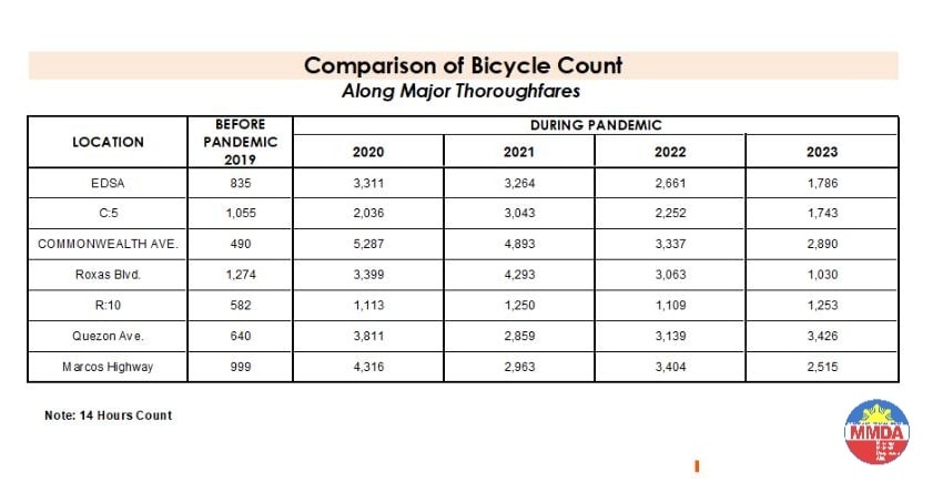
These are supposed to be official data as it is issued by the government agency in-charge of traffic management for Metro Manila roads (aside from its other functions and roles). What are not stated, and are actually very important details, are the locations of the counts and when the counts were conducted. The Traffic Engineering Center (TEC) that was under the DPWH and currently with the MMDA used to publish traffic volume maps for major roads in Metro Manila. So along EDSA, for example, the volume per section are shown on the map. The same for other major roads like Commonwealth, Quezon Avenue and SLEX. The thicker lines mean higher volumes along those sections, and vice versa. However, they did not consciously count bicycles (only motor vehicles) and perhaps MMDA only started counting during the pandemic (i.e., 2020). So there is no one value to represent a road. And counts vary over time of day, day of the week and even throughout the year (i.e., monthly variations).
There were many reactions to the MMDA’s posting of the data and most were critical and even derided the agency for what to them appeared to be inaccurate data. The problem is that it seems there are no other counts that can validate and perhaps refute the MMDA data. Previous bike counts were not conducted according to how the MMDA and DPWH count vehicles. That is, counts are typically done over a 14 or 16-hour period and ideally on several days in a year. Expansion and conversion factors are applied based on established stations along major roads that are supposed to have more frequent if not continuous counts. This methodology is how Annual Average Daily Traffic (AADT) is computed. Call it car-centric if you like but the methodology is very much applicable to bicycles as well. Peak hour counts for bikes are not enough and the peak hour factor for motor vehicles does not apply to bicycles (if this is to be used to expand/convert peak volumes to daily values). In fact, if you go into the math, there should be a peak hour factor for each type of vehicle considering each vehicle’s volume will vary differently over time. So yes, the solution here is to conduct bicycle counts according to how MMDA or DPWH counts vehicles and these should be done along several stations along major roads (e.g., those in the table above) to validate the MMDA counts.
More on this topic in the next post!
–
A widened Col. Bonny Serrano Avenue and opportunities for complete streets
Col. Bonny Serrano Avenue is one of the major roads directly connecting EDSA (C-4) and C.P. Garcia Avenue (C-5). The last time I used the road was before the pandemic. So it came as a surprise to pass by last weekend and see the avenue had been widened. I guess that pretty much “solved” the traffic along this usually busy thoroughfare that is part of jeepney routes to Cubao (via Murphy – referring to Camp Aguinaldo, which was formerly Camp Murphy). The avenue was renamed after a Korean War Hero (my uncle fought under him with the 10th Battalion Combat Team in the Korean War in the 1950s). It was called Santolan Road before.
 What used to be a 4-lane road is now an 8-lane road
The area used for road widening was carved out of Camp Aguinaldo. The headquarters of the Armed Forces of the Philippines (AFP) gave up quite a lot of square meters for this project and you can see from the photo the now very wide avenue. I thought perhaps they could have placed a median island where they could have also planted some trees (note how exposed to the sun the area is). They also could have designed protected bike lanes along either side of the road. These could have connected the EDSA and C5 bike lanes. And, of course, they should have also improved the pedestrian sidewalks. You can see how narrow the sidewalks are and how electric and light posts block pedestrians using the sidewalks. There were opportunities here for the application of complete streets and its not too late to do just that.
I assume there are many men in uniform who use bicycles for their commutes and recreation. Camp Crame is just across EDSA from Camp Aguinaldo and Bonny Serrano Avenue also passes along the headquarters of the Philippine National Police (PNP). Down the road towards Marikina City in Libis is another camp, Camp Atienza, which is home to the 51st Engineering Brigade of the Philippine Army. I mention these camps as I know many there regularly use Bonny Serrano for commuting and many use bicycles. A cousin-in-law (my wife’s first cousin) who is an army officer bikes a lot from Camp Atienza and Camp Aguinaldo and tells me there are many enlisted men who bike to work.
–
Article share: on making more affordable neighborhoods
I’ve been commenting about how transportation cannot be isolated and the need to relate it to other factors such as housing or home location choice. The latter though is also affected by other factors as well that affect the affordability of homes near the city centers or CBDs where workplaces and schools are located. The result of course is sprawl or the encouragement of sprawl. Private companies take advantage of this or contribute to this ‘encouragement’ by developing land farther away from the center. Thus, for Metro Manila’s case, many people reside in the peripheral provinces of Bulacan, Rizal, Laguna and Cavite. There are even those who choose to reside in Pampanga, Bataan and Batangas.
Kayatekin, C.S. and Sanmiguel, L.U. (April 16, 2024) ” ‘Urban form’ and the housing crisis: can streets and buildings make a neighborhood more affordable?” The Conversation, https://theconversation.com/urban-form-and-the-housing-crisis-can-streets-and-buildings-make-a-neighbourhood-more-affordable-224108 [Last accessed: 4/23/2024]
Quoting from the article:
“Our main finding was that the bottom-up districts we looked at had, overall, more small-scale apartments. The reason is simple: they had more small-scale buildings, built on small-scale plots. Once divided into apartments, this produces small apartments – homes in the bottom-up areas were 10% to 23.1% smaller than their top-down counterparts. This also made their real estate markets for small homes more competitive, and therefore more affordable.
However, our study showed there is nothing inherently magical about bottom-up areas. Their more intricate housing stock has little to do with the layout of streets and blocks, and a lot to do with how that land is built upon.
Plot size appears to be the deciding factor: the districts with greater numbers of small buildings built on small plots supported a denser and more affordable housing stock, regardless of whether they were top-down or bottom-up.
Older bottom-up areas seem to naturally lend themselves to having more small-scale plots. This is likely due to the incremental development of these areas, and the complex land ownership patterns that developed as a result. However, there is no reason why a top-down area cannot be designed to replicate these characteristics.”
–
UP’s University Avenue
A week ago, I was invited to witness the renewal of a Memorandum of Understanding (MOU) between UP Diliman and a leading and prominent engineering company. I think one of the highlights of that event was getting to go to the Board of Regents meeting room at the top of Quezon Hall. This used to be an open area that we went to during our college days. The only times the place was off limits was when there were important meetings at Quezon Hall (e.g,, meetings of the UP Board of Regents) and during commencement exercises. It has been transformed into an air-conditioned facility that now hosts offices and this conference room. What’s the transportation thing in this post is the magnificent view of the University Avenue, which is the main gateway to the campus.
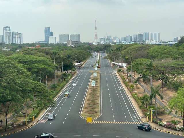 UP Diliman’s University Avenue as seen from the top of Quezon Hall
The University Avenue has also evolved as it now features bike lanes along each direction of the road. There are walkways that also served as bike lanes along either side of the avenue. These are visible in the photo and are protected, exclusive ROWs from the main travel lanes that used to be assigned to motorized traffic. The avenue connects UP’s Academic Oval, its campus core, to Commonwealth Avenue. I remember splendid sunsets viewed from the same vantage point as this generally faces the west.
–
Lower speed limits may not slow drivers, a before-and-after study shows
I am sharing this article on drivers not reducing their speeds after speed limits have been lowered along certain roads. My first reaction after reading the article is that it is that perhaps in the US case, the after study was conducted quite early and before people have become aware, understood and adjusted to the lower speed limits. The responses or reactions to lower speed limits (particularly those posted or on signs) may vary among cities and countries. In the Philippines, where drivers and riders appear to be oblivious to speed limits, other interventions may be required including some types of traffic calming devices. This is very much a concern particularly in school zones where children are exposed to the risks of being run over by motor vehicles speeding along the roads and not minding the speed limits in the area.
Here is the Research report:
Source: Lower speed limits may not slow drivers, a before-and-after study shows
Article share: on using optical narrowing to make streets safer
I’m sharing this interesting article on the concept and application of optical narrowing to improve road safety:
Erfurt, E. (September 15, 2023) “How to Use Optical Narrowing to Make a Street Safer,” Strong Towns, https://www.strongtowns.org/journal/2023/9/15/how-to-use-optical-narrowing-to-make-a-street-safer?fbclid=IwAR147sLmkMBwStj51FR1ehNcVsi1YpN70etrpGOwv9DHL4ZhJIDLzP8cb1s [Last accessed: 3/14/2024]
To quote from the article:
“We all perceive the world around us through visual reference points. As we look around, we are next to the wall, or across the street from the bank—in other words, we position ourselves relative to what we see. This is even more apparent when we are driving: you may perceive yourself as behind another car, or between the lines on the road.
Drivers make decisions based on these visual cues. If things are further away, we are more inclined to speed up. The auto industry has marketed this as the “freedom of the open road,” and the visual of a wide open road is paired with the acceleration of the car. If no one is near and all the fixed objects, such as curbs and buildings, are far away, then the perception is that we have less risk and we throw caution to the wind.
If things are closer, we are more inclined to slow down. Our natural inclination is caution and possibly a little bit a fear that we may hit something. When you drive on a street where the lanes are a little narrower, or the buildings are at the back of the sidewalk, our reference points become closer. We have to focus, and in an abundance of caution we drive slower. The perspective is that we have more risk, and we pay more attention to counter that risk.”
This would be a good quick reference to planners and engineers who are involved in road safety, particularly in applying complete streets concepts to reduce the risk of crashes along streets.
–
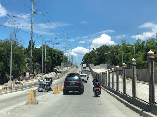
Widening of Gen. Santos Avenue, Taguig City
This is a very late post. I saw this draft that I made more than 7 months ago when I passed by General Santos Avenue in Taguig en route to Laguna where I was to attend a nephew’s wedding. General Santos Avenue is the road connecting C6 with the South Luzon Expressway (SLEX).
 Fence dividing traffic along either side of the road
 The fence stretches along a significant length of the avenue, effectively preventing people from crossing the street anywhere.
 Unfinished section (should be done by now) showing the original carriageway on the left. The new lanes due to the road widening project is on land acquired from the DOST lot on the right.
 It becomes clear in this photo that the median of the widened road is actually where the walls of the DOST compound used to be. Note the dead end where DOST land has not been expropriated yet for the road widening project.
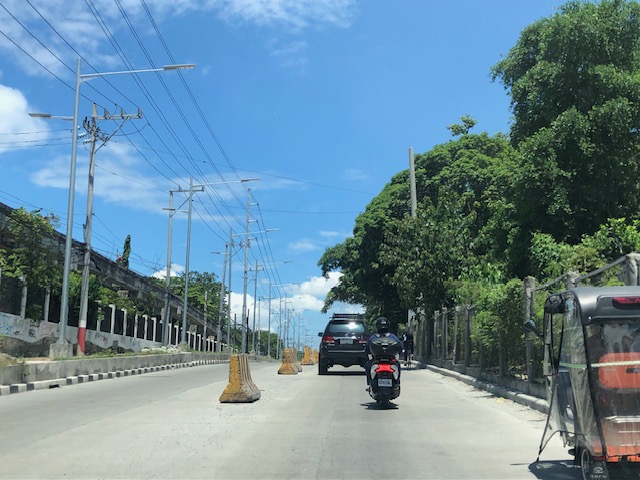 Either side of the road are DOST lands. The main compound is at right while the left is the MIRDC compound.
 The experimental Automated Guideway Transit (AGT) is found at the MIRDC compound.
More on similar cases in future posts. Road widening projects are very popular with the DPWH, and the agency has been criticized for being somewhat lazy or applying a non-imaginative approach to solve traffic problems. The project is a good example of DPWH fulfilling its mandate. Never-mind that this is not a sustainable approach to addressing transport problems.
–
On the Pasig River esplanade project
My news feed was full of articles on the Pasig River esplanade, or at least the recently completed section at the Manila Central Post Office building. This is a proof of concept type of project that hopes to be expanded or extended to cover both sides of the river much like the Iloilo River Esplanade project. If you are wondering what the section looked like before the project, here are two posts I wrote in 2012 that features a lot of photos of the Muelle del Rio:
These were way before the fire that damaged the Post Office building. However, even at that time, there were already calls for the renovation, even repurposing of the Post Office building. Such projects or proposal draw inspiration from Singapore where old buildings have been preserved and many repurposed (e.g., how about the Post Office building transformed into a hotel?). Perhaps such will breathe life and lead to a revival of this part of Manila?
–
On bike lanes network development – examples in the US
I am sharing this article on the best new bike lanes in the United States:
Haggerty, M. (January 12, 2024) “The Best New U.S. Bike Lanes of 2023,” People for Bikes, https://www.peopleforbikes.org/news/the-best-new-u.s.-bike-lanes-of-2023 [Last accessed: 1/23/2024]
Quoting from the article:
“Even for the most ardent naysayers, it’s difficult to deny that the landscape of bicycling in America is transforming (although not as quickly as many of us would like to see). While we have yet to see any U.S. cities emerge with truly bold citywide plans for bike networks as we’ve seen in places like London, Paris, and Bogota, many are (slowly) beginning to envision a future where cycling takes center stage. Although there remains a substantial amount of work ahead of us to cultivate a safe and comfortable environment for people of all ages and abilities to ride bikes in the U.S., it’s well worth pausing to commemorate the significant infrastructure victories U.S. cities achieved in 2023.”
The quote above also applies to us in the Philippines where there are still few examples of safe and comfortable bike lanes. I shared the same article on my social media page asking aloud if there’s something like this in the Philippines. I am aware of the Mobility Awards but that’s supposed to cover everything on mobility and particularly walking and cycling. The list is about bike lanes and touches on the various designs (note that in the US, while there are federal guidelines, most if not all states and cities would have their own that they use for planning and design of bicycle facilities). It would be nice to have our cities develop guidelines while also referring to the minimum standards in the DPWH Guidelines. Of course, the challenge is to come up with good if not the best designs and not just comply with the minimum.
 If there was an award for best new bike lanes in 2023, I think Quezon City will have several nominees and even win the award with one. Picture above is the bike lane along Katipunan Avenue/C5.
–
