
Home » Infrastructure (Page 11)
Category Archives: Infrastructure
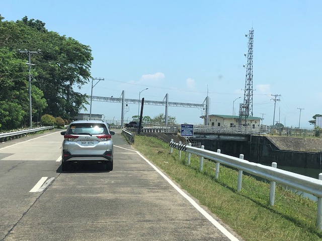
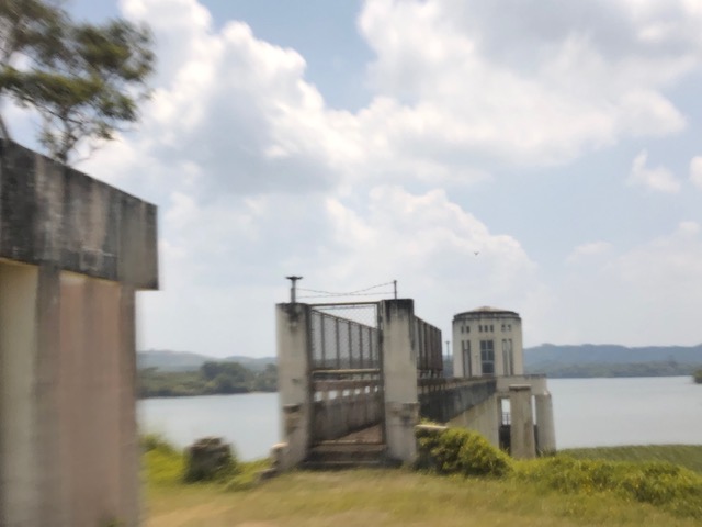
Roadside scenes – the Kalayaan hydro power plant
Last weekend’s getaway allowed me to take a few quick photos of a familiar sight that is the Kalayaan hydro-electric power plant located in the town of Lumban, Laguna at its border with Kalayaan town in the same province. Built in 1982, it was the first of its kind in Southeast Asia and is the only pumped storage plant in the Philippines. Basically, what ‘pumped storage’ means is that it can reverse its turbine to suck water from the basin at the level of Laguna de Bai to charge what could be a depleted Caliraya reservoir. It can then draw water from the lake to generate power. If water levels at the reservoir are normal to high such as during the wet season, it can draw water more than it needs to pump back into the lake.


There is another power plant in the area, the Caliraya Hydro Electric Power Plant. It is not located along the national highway but to the west of the northern tip of the lake and near Pagsanjan River. I will write about that in another article.
Are roads really designed just for cars?
The answer is no. Roads were and are built as basic infrastructure for transport no matter what the mode. However, the standards for dimensions (i.e., number of lanes, widths, etc.) are based on the motor vehicle capacity, and structural standards (i.e., thickness, strength, reinforcement, etc.) are based on the weights they are supposed to carry over their economic lives. The pavement load as it is referred to is usually based on the cumulative heavy vehicle traffic converted in terms of the equivalent standard or single axles or ESA. An ESA is 18,000 pounds or 18 kips in the English system of measurements or 8.2 metric tons in the Metric system.
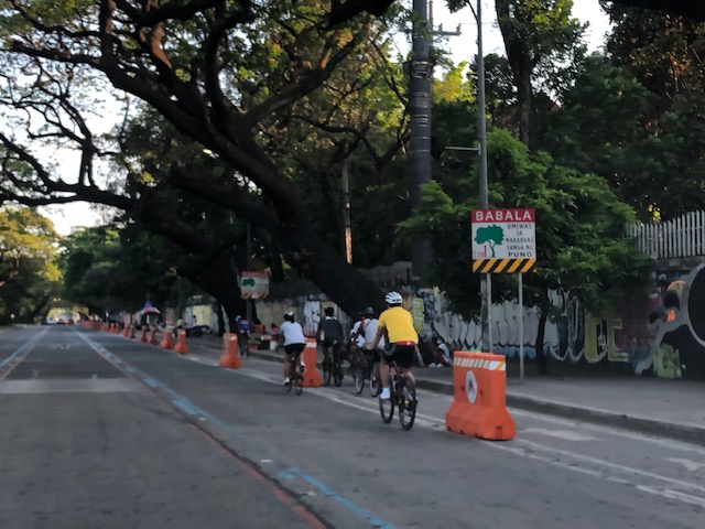
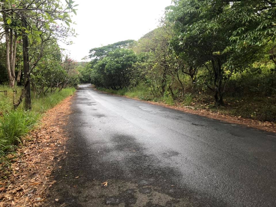 A typical local road – is it really just for cars or is it also for walking and cycling? Or perhaps animal drawn transport?
A colleague says many of the posts in social media pitting bicycles with cars are already quite OA (overacting). I tend to agree as I read how people generalize roads being car-centric. Roads have been built basically to serve a avenues for transportation. They were improved over time in order to have more efficient ways to travel by land. It didn’t hurt that vehicle technology also developed over time and bicycles somehow became less popular than the cars and motorcycles. The motorcycle itself evolved from bicycles so in a way, it is the evolved and mechanized form of the two-wheeler.
In a perfect world, people would be sharing the road space and it would be equitable among different users. In a perfect world perhaps, it won’t be car-centric as there would probably be better public transport options and transit will be efficient, reliable, comfortable and convenient to use.
The reality, however, is that we do not live in a perfect world and transformations like the ones being pitched on social media are nice but are also not as inclusive and equitable as their advocates claim them to be. I’ve always said and written that you cannot simply change transportation without also implementing changes in land use and housing in particular.
Why do we need wide roads connecting suburbs and urban areas? Why is there sprawl? Why do people live in the periphery of CBDs or the metropolis? It is not just about transport though it seems easier to focus on this. Even transportation in Japan, with Metropolitan Tokyo and its equivalent of NCR plus as a subject, needs to be properly contextualized for land use and transport interaction and development. It seems that even with a comprehensive and efficient railway network, there are still shortcomings here and there. We don’t have such a railway network (yet) so we need to find ways for easing the currently long and painful commutes many people experience on a daily basis. That means continued dependence on road-based transport and trying to implement programs and schemes to improve operations.
–
In defense of expressways
Expressways have been on the receiving end of criticisms and bad press lately mainly due to the recent much publicized proposal of a Pasig River Expressway (PAREX) by a private corporation. While I also do not agree with the alignment of this proposed tollway, I take exception to the generalization of expressways as sort of a manifestation of evil.
There seem to a lot of information being posted about and vs. expressways. However, it is important to sort through the hype as well as the misinformation that people tend to post about expressways. Yes, there are expressways being demolished or that have been demolished in other countries. These were probably so because they were ill-planned in the first place as are many other elevated pathways (e.g., poorly planned and designed footbridges), and many of the cities removing them have also developed their transport systems to be more efficient in terms of their people’s mobility. That is the case with Seoul and that certainly is the case for Tokyo. In fact, Tokyo had been moving their surface railways underground for the past decades. And now it seems they will be doing so for certain expressways. Does Tokyo have an efficient transport system? It does and perhaps is among the densest if not the most extensive rail and road system in the world.
It is important to have context to the matter. NLEX and SLEX, for example, were developed as relatively free-flowing, high capacity, high-speed roads that were the alternative to the national highways that directly connected many municipalities and cities. The latter had many intersections or junctions with other national roads as well as carry mainly local traffic including public transport such as tricycles and jeepneys. Expressways are built to be part of the primary arterial network and not as local roads. They are built for access rather than mobility.
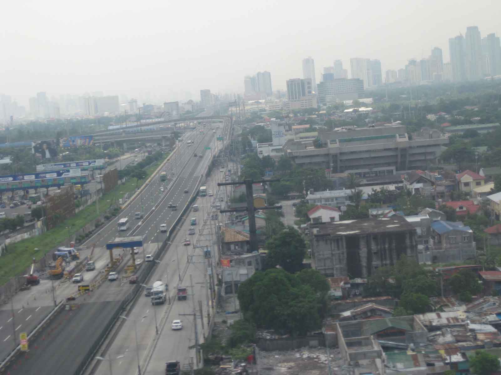 From L-R: SLEX, Skyway, and the East Service Road. The Skyway connects the NAIA-X to the left and the NLEX connector section onwards through. SLEX eventually becomes the South Super Highway, which is an urban street.
So, are expressways anti-pedestrian? Basically, no. Though they clearly were not developed or constructed with walking in mind. In fact, expressways are generally built along secured right-of-way and are limited access facilities. In the Philippines, all expressways are tolled; meaning you have to pay to use them. Expressways are built more for long distance travel and not for the shorter ones where walking is most appropriate.
Are they car-centric? Not necessarily so because they provide a less congested alternative for long distance transport of people (buses and vans) and goods (trucks). Would you rather take the Manila North Road (McArthur Highway) to Baguio City and endure over 7 hours travel time? Or would you take the 4-hour trip via 3 expressways (NLEX, SCTEX and TPLEX)?
Are expressways supposed to reduce traffic on local roads? Yes and no. Yes, because they actually do reduce traffic at the local level when you divert long distance travel to expressways. The math tells us there is subtraction there. However, it is a no in terms of local traffic increasing over time, which should not be charged to expressways, as they are a function of other elements coming into play including population increase and economic growth. This includes a contribution to induced traffic or new trips generated by the perception of infrastructure being adequate and having the capacity to cater to more trips that are not necessarily borne by cars.
Do we need more expressways? Probably, but not in the locations or alignments like the one proposed for PAREX. Incidentally, there is another expressway being planned that seems to have escaped the attention of those against PAREX. I am talking about the Laguna Lakeshore Expressway that will be a combination of at-grade (over reclaimed land) and elevated (viaduct over the Laguna de Bai) sections leading to heart of Laguna and towards Quezon province. But that’s another story…
–
Inter-island bridges in the Philippines – Nice to have but not necessary at this time?
A news article came out yesterday, reporting on the shelving of several inter-island bridge projects as well as the progress of only 3 projects include the Panguil Bay Bridge. Many of these projects have been conceptualized a long time ago but were being fleshed out through various feasibility studies.
I’ve written before about these bridges, and had a healthy discussion among friends about the merits and demerits of such infrastructure when there are other, more urgent projects that would probably have higher impacts. One friend was involved in studying the connection between Panay and Negros islands, and had concluded that the cost can be justified by the economic benefits brought about by the bridge. I disagreed, stating the costs could cover modern urban transit systems at least in the major cities of Iloilo and Bacolod.
With limited resources and the likelihood of these projects being funded from various foreign loans make them unpalatable since these will mean more debt for the country. Also, these projects will benefit fewer people compared to other transport projects including modernizing public transportation and building bike lane networks. The latter kinds of projects are for daily commuters whereas the bridges are more for occasional travelers. What do you think?
–
If you build the bike lanes, will people use them?
The obvious answer to this question is yes. It is not so clear, however, how many will really be using these bike lanes over time. That needs data. That requires counting. And such data will be useful in order to understand, among other things, why people choose to bike or why they don’t. The latter is important to determine what factors are being considered by people who can switch to cycling particularly for commuting. Of course, there are many references for this from other cities and countries but these still need to be contextualized from our (Philippine) perspective. Case in point is Marikina, which has the most comprehensive network of bike lanes in the country. What are the numbers and what are the constraints and misconceptions? Did the city do its part to promote and sustain cycling?
Here is an article discussing the experience in the US:
Penney, V. (April 1, 2021) “If You Build It, They Will Bike: Pop-Up Lanes Increased Cycling During Pandemic,” The New York Times, https://www.nytimes.com/2021/04/01/climate/bikes-climate-change.html?smid=url-share [Last accessed: 4/9/2021]
 Bike lane along Katipunan Avenue (C5) in Quezon City
Here is the link to the paper mentioned in the article:
https://www.pnas.org/content/118/15/e2024399118
–
On the principles of good infrastructure
Since the Philippine government is engaged in its Build, Build, Build infrastructure development program, and agencies like the DPWH and DOTr often or regularly refer to what’s happening in the US in terms of projects, guidelines and standards, I am sharing the following article on the principle
Marshall, A. (March 18, 2021)“What Are the Five Principles of Good Infrastructure?” Governing.com, https://www.governing.com/community/Five-Principles-Good-Infrastructure.html [Last accessed: 4/5/2021]
Despite obviously being an article about US infrastructure in the context of the new administration there, there are just too many takeaways or relevant information here that applies to us and how we are developing and maintaining our infrastructure. To quote:
“First of all, cost matters. The evidence is pretty clear now that we pay several times more than other advanced nations to build transit infrastructure, particularly tunnels, and possibly highways as well. It appears we pay too much to build public parks.
Second, time matters. We still get estimates for infrastructure projects whose construction stretches into decades, when it should be a few years. Time relates to cost. Adding time makes projects more expensive.
Third, connections matter. Whether it’s a light-rail line joining up to a bus line, or an interstate exit linking to a town, the connections between infrastructure systems are important. High-speed rail lines need to intersect seamlessly with the cities they serve. Infrastructure can’t be designed in a vacuum. Urban planners and designers should be at the top of the infrastructure food chain, so that transportation and other departments work for comprehensive visions.
Fourth, design matters. Western Europe has been erecting light, airy bridges for decades, while we have continued to build heavy concrete slabs. This is changing, but we lag behind other countries in the design quality of everything from bridges to subways.
Finally, ownership matters. Even the best-designed and swiftly built infrastructure will turn bad if we give one or two private companies total control over them. As we use private companies for broadband, cable, telephones, data management and the power that runs our homes, we need to remember this. When we can’t (or won’t) have public systems, then the private ones need to be carefully managed.”
To what extent do you think these principles apply to our case?
–
On leaders and decision-makers taking public transport or bikes to commute
There has been clamor for our leaders and decision-makers, especially those in the transport and highway agencies, to take public transportation. This is for them to experience how most commuters fare for their daily grinds. And no, having an entourage including bodyguards or reserving your own train car does not count. Dapat pumila o maghintay sa kalye. Makipagsisikan o makipag-habulan sa bus, jeepney o van para makasakay. Many if not most of these officials have their own vehicles or are even driven (may tsuper o driver) to and from work. One even had the gall to transfer his department to where he comfortably resides so he won’t commute but that’s another story.
You see articles and posts about Dutch politicians and even royalty riding the bicycle to work.
 The Dutch Prime Minister bikes to work
Then there are politicians regularly taking public transport while in office. Here is an article about the newly inaugurated POTUS, Joe Biden, who took the train for his regular commutes:
Igoe, K.J. (May 4,2020) “Where Did “Amtrak Joe,” Joe Biden’s Nickname, Come From?”, Marie Claire, https://www.marieclaire.com/politics/a32363173/joe-biden-amtrak-joe-meaning/ [Last accessed 2/14/2021]
Do we have someone close to such an example? Commuting by private plane between your home in the Southern Philippines and your office in Manila surely won’t let one have an appreciation of the commuting experiences of typical Filipinos.
–
Lessons on housing we need to talk about
There’s this recent article on housing that presents and discusses lessons from Singapore housing that
Fischer, R. (February 2, 2021) “Singapore Housing Lessons for the Biden Administration,” Planetizen, https://www.planetizen.com/node/112077?utm_source=newswire&utm_medium=email&utm_campaign=news-02082021&mc_cid=4fac9821d0&mc_eid=9ccfe464b1 [Last accessed: 2/15/2021]
 I’m not an expert on housing but I’ve experienced living in Singapore. Here’s a photo of the wife as she walked ahead of me on our way to the MRT station near our place back in 2012. One of the factors we considered when we chose this place for our residence was its proximity to the orange line station that meant only one ride (no transfers) between our home station and the station closest to the wife’s office. We could also take the train to the nearest mall if we didn’t feel like walking 15 minutes.
To quote from the article:
“…the secret to Singapore’s success is that their housing projects are carefully designed to support mixed-incomes, beautiful green spaces, and access to high-quality public transportation that conveniently links residents to education and community centers. And last but not least, couple all that with the famous Singapore hawker centers (food courts) where all income classes and ethnicities meet, socialize, and dine on Singapore’s famously delicious and affordable cuisine.”
–
On congested tollways during the pandemic
I finally was able to go on a long road trip yesterday as friends invited us to go on an excursion to Quezon to a prominent pottery artist’s place in the town of Tiaong. I first thought we would be going via the backdoor of Rizal since we were already in Antipolo but it turned out that it would be faster via the tollways route. Both Google and Waze recommend our route via C-6, SLEX and STAR to get to our destination. It could have been longer via the Manila East Road but which is a more scenic route. While it took us only 2.5 hours to get to our destination, it took an additional hour on the way back. Part of it was the congestion along the national highway between Tiaong and Sto. Tomas, Batangas but I was also a bit surprised about the congestion along SLEX on the way back (photo below) but saw that this was mainly due to vehicles filing towards the Skyway ramp in Alabang.
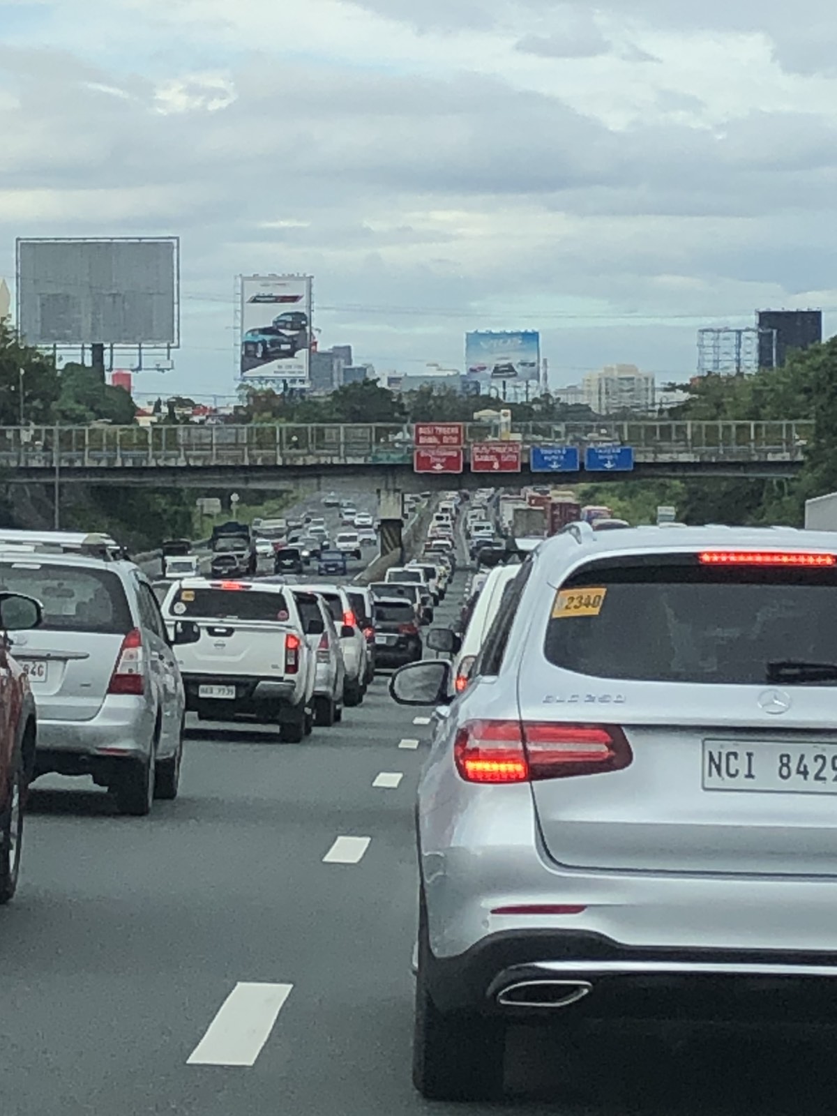
There was the expected congestion at the toll plazas as vehicles still need to slow down. It is not like the seamless, structure-less system in Singapore where their sensors can detect vehicles running at high speeds. The toll barriers are still there and the channels for one are relatively narrow. Then, there are travelers that seem hard in understanding that there are specific booths for cash payments. Also, there were occasions when the barriers did not lift immediately for one reason or another. That tends to slow down the processing of queued vehicles – a problem that my undergraduate students could probably take on after their lessons in queuing theory.
–
On planning our cities from a child’s perspective
Wouldn’t it be interesting to find how children would plan their cities? No, this is not the lego building kind of exercise but something closer to actual planning exercises where children not only act as planners but stakeholders themselves. We always say they are the future and that know that they will inherit whatever good or bad we are doing now, and yet they have little say in that future. Perhaps we should heed what they think our cities require?
Ergler, C. (January 4, 2021) “Young children are intuitive urban planners — we would all benefit from living in their ‘care-full’ cities”, The Conversation, https://theconversation.com/young-children-are-intuitive-urban-planners-we-would-all-benefit-from-living-in-their-care-full-cities-151365 [Last accessed: 1/15/2021]
–
