
Home » Infrastructure (Page 7)
Category Archives: Infrastructure
On the Robinsons Antipolo Transport Terminal – again
I took the following photos of the transport terminal at Robinsons Antipolo last December 24. I have shared photos at the ground level and mostly close-ups of the buses, vans and tricycles that operate to and from the terminal. I was at the toy shop last Saturday for a last minute purchase and saw a nice vantage point to show the expanse of the terminal.
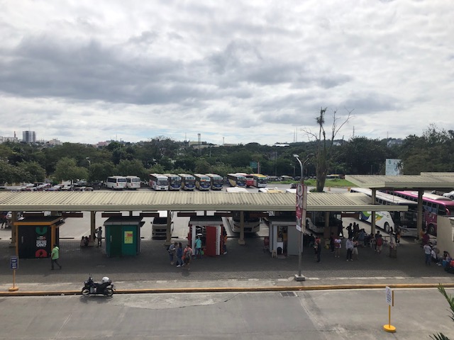 Bus ports and garage (in the distance)
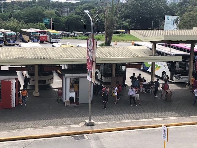 There are regular trips here between Antipolo and Cubao (aircon buses), Antipolo and Ortigas Center (P2P buses), and Antipolo and other provinces (Quezon, Bicol, Samar, Leyte and Bohol).
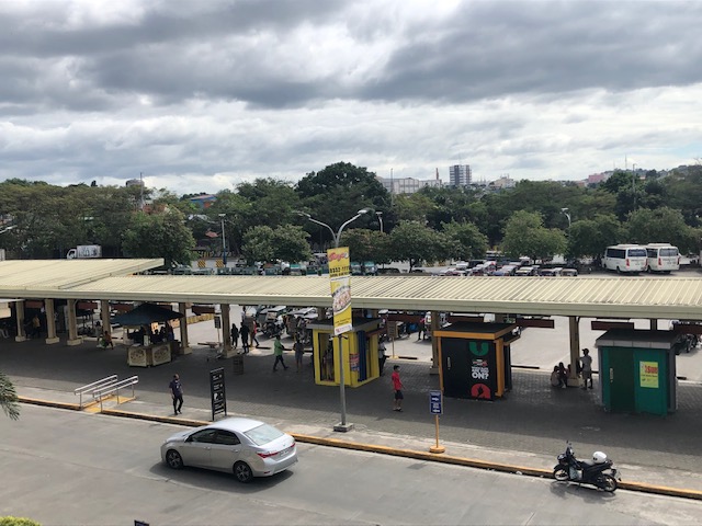 People can transfer to modern Jeepneys (actually mini buses) that ply the Antipolo-Marikina route or perhaps take a tricycle (conventional or electric) to their final destinations.
–
On the future of bike lanes in Metro Manila and other cities and municipalities in the Philippines
My friends and I were talking about the current buzz about the bike lanes including statements made by certain personalities (influencers, advocates, government officials, etc.) about biking and bike lanes. There were many recent pronouncements of motorcycles being allowed to use bike lanes or the outright removal of bike lanes. We all agreed this was backward and the way forward is to build on the current network and facilities. What we have in our cities and municipalities are not perfect and far from ideal but they are a start and perhaps the foundation for a bikeway network that can eventually make a dent on the car-centric transportation we have.
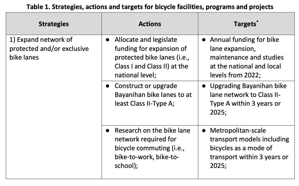
I share below the strategies, actions and targets for bicycle facilities, programs and projects from the Network Planning for the Establishment of Bike Lanes in Metro Manila, Metro Cebu and Metro Davao that was completed middle of 2022. The project is DOTr’s with support from the UNDP. The table is from the Final Report of the project.


A Happy Christmas to all!
–
Departure via Mactan Cebu International Airport Terminal 2 – Part 1
The MCIA has two terminals with the newer Terminal 2 being lauded as one of the best designed terminals in the country. It has been recognized internationally, too. And this is mainly due to the architecture of the new terminal.
 Approach ramp to the departure level of MCIA Terminal 2
 Departure level driveway – the area looks spacious but you wonder how it is during the peak season.
 The view upon alighting from the vehicle that took us to the airport – note the advisory stating Cebu Pacific departures are via the old Terminal 1.
 The walkway leading to the terminal building is very spacious.
 Passengers may use the baggage trolley for their convenience in hauling their luggage.
 There are seats for travelers and their well-wishers.
 One of the kiosks along the corridor leading to the terminal building
 The view from the walkway shows the Waterfront Hotel with its tiled roofs and the older MCIA Terminal 1 building (at right in the photo).
 A local coffee shop operates out of one of the outdoor kiosks. These kiosks serve both travelers and well-wishers.
 Inside, a popular souvenir shop welcomes travelers.
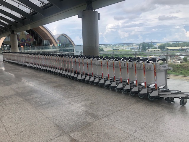
 Schedule of departures are shown on one of the screens inside the terminal building.
 Info booths of some of the airlines using Terminal 2
 The Terminal 2 building offers very impressive architectural details.
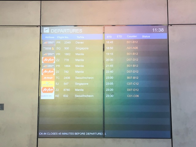
 There were long lines not because the airport is crowded but because there were few check-in counters open. Even those who have checked-in online and were to drop-off their bags were not spared the queues.
 Stained glass windows featuring what appears to be a giant parol (Christmas lantern).
 A view of the other check-in counters at the spacious MCIA Terminal 2
 I took this photo of the ceiling to show the incorporation of natural lighting elements that allow for less power consumption for lighting particularly during daytime. This is one of the eco-friendly features of the building.
 Another view of the long queues for PAL after we finished checking-in.
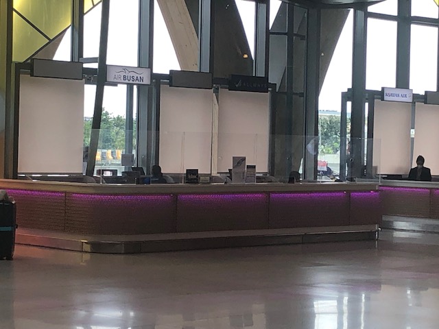 Airline service and information counters at the terminal – these are for Air Busan and Korean Air. An Air Busan plane figured in a crash recently when it overshot the runway upon landing at the MCIA in bad weather.
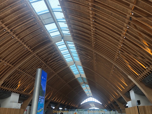 Another view of the ceiling and roof
 Guidance for passengers are posted at the check-in counters. These include info on items that are not allowed in the check in bags, what are prohibited and will be seized at the airport, and what are allowed only in check in bags. The scale readout is working and can be seen on the counter. Typical luggage limit for domestic passengers range from 20 to 25kg depending on the airline.
Part 2 is coming soon!
–
On reducing driving and its inherent risks
Ever since the automobile was invented and eventually mass-produced, there has been an increasing risk associated with motor vehicle traffic. Laws, policies and regulations have also been influenced to favor the car rather than people. And so we now have what is termed as a car-oriented and dependent transportation system that seems so difficult to undo as most people appear to be enamored by the car. Owning a car (or even a motorcycle if you want to extend this idea of individual ownership) remains an aspiration to a lot of people.
Here is a link to the compact version of a comprehensive report by Todd Litman that presents and argues for a new paradigm where driving is considered a risk factor. There are data and a table comparing old and new traffic paradigms to help us understand the situation and what needs to be redefined or re-framed in order to achieve our safety targets or vision.
Litman, T. (October 20, 2022) “Driving as a Risk Factor: A New Paradigm,” Planetizen, https://www.planetizen.com/blogs/119287-driving-risk-factor-new-paradigm?utm_source=newswire&utm_medium=email&utm_campaign=news-10202022&mc_cid=beacdc2a04&mc_eid=9ccfe464b1 [Last accessed: 10/28/2022]
To quote from the article:
“Safer vehicles, roads, and driving may reduce crashes but achieve few other goals, and sometimes contradict them. Transportation demand management and smart growth policies increase safety in addition to helping to achieve other planning goals, and so can be considered win-win solutions.
More comprehensive safety analysis tends to support social equity goals. Many conventional safety strategies, such as larger vehicles with more passenger protection, and wider roads with fewer intersections, tend to increase walking and bicycling risks. In contrast, lower traffic speeds, TDM, and Smart Growth tend to improve safety, mobility, and accessibility for people who cannot, should not, or prefer not to drive.”
The key takeaway here should be that people should have the option of not driving at all in order to reduce the risks associated with driving as well as reduce congestion. A more comprehensive
–
Who can design bikeways?
I have read many comments about how bike lanes and other bike facilities are sub-standard or unacceptable because they were designed by non-cyclists. From an academic perspective and perhaps also from a point of view of someone who values empathy, the planning and design of bicycle facilities should not be so limited. The objective of education, and particularly for schools whose graduates become professionals like engineers, architects and planners, should be to have the latter be able to plan and design the most suitable infrastructure and facilities for all users. Suitability here should include equity considering the many elements involved for people of different gender, physical ability or disability, age, health conditions, etc. That said, it is the responsibility of agencies such as the Department of Public Works and Highways (DPWH) to revise and update their design manuals and guidelines to ensure that these are according to International standards and mindful of the best practices in various cities and countries that are now very well documented.
 Bike lane in BGC,Taguig City
 Bike lane and jogging/walking lane in UP Diliman
–
On animal – vehicle collissions
We feature a different type of road crash today – one involving wildlife and vehicles. This is not something new as I am sure you’ve seen all those road kills (usually cats or dogs) along many of our streets and highways. These don’t even include the frogs, birds and other animals that are killed by motor vehicle traffic. Here is an informative article on such crashes or collisions and what can be done to address them.
Skroch, M. (October 4, 2022) “The dreadful toll of wildlife – vehicle collisions – and what we can do about it,” Governing, https://www.governing.com/now/the-dreadful-toll-of-wildlife-vehicle-collisions-and-what-we-can-do-about-it [Last accessed: 10/10/2020]
To quote from the article:
“Advances in research technology over the past decade have revolutionized experts’ understanding of how wildlife move across landscapes and are now helping to resolve wildlife-vehicle conflicts that are rising due to increased development. One example is GPS collars that are affixed to big game, as well as other mammals and birds, and transmit electronic signals via satellite from some of the most remote regions in the U.S. to researchers throughout the country. This data captures exactly where and when animals move within large landscapes, enabling scientists and engineers to pinpoint where the construction of wildlife crossings — mostly overpasses and underpasses that help animals traverse highways — can most effectively improve motorist safety and facilitate animal migrations. Studies show that a well-placed underpass or overpass can reduce wildlife-vehicle accidents by over 90 percent, providing a high rate of return on federal and state investments in such structures.”
–
On electric vehicles and informal transport
I’ve been involved in studies on electric vehicles and their applications in the past. I continue to take part in studies about informal transport including continuing research on motorcycle taxis or “habal-habal” as they are called in the Philippines. The combination of the two is an interesting research area and there are many topics that can be developed as we determine the most appropriate applications for electric vehicles. Here is an interesting article on electrifying informal transport that sets the context for research:
Ribet, L. (August 30, 2022) “The role of data in electrifying informal transport,” Slocat partnership, https://slocat.net/the-role-of-data-in-electrifying-informal-transport/ [Last accessed: 9/9/2022]
To quote from the article:
“However, electric two-and-three wheeler startups, informal transport retrofitting pilots and e-bus initiatives cannot be the only answer to the mobility challenges facing developing cities. Phasing out oil-reliant public transportation is needed and investing in electric mobility solutions may well improve the overall picture quite substantially, but there is a far larger challenge that is omitted from these ambitions: addressing the complex operations of informal transport systems that characterise lower-income countries’ urban mobility. Electrifying minibus taxis is not synonymous with more reliable, affordable and convenient public transport, and we need to prioritise the understanding and improvement of overall informal transport systems data first.”
–
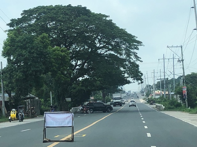
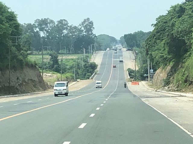
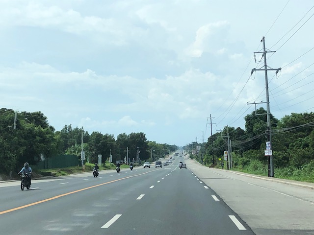
The wide Roman Highway, Bataan
As it is National Heroes Day today, I thought it would be nice to feature a road in an area that witnessed the experiences and sacrifices of many heroes. I traveled to Bataan last July and took some photos of the roads there including the Roman Highway, which is the main corridor connecting many of the province’s major towns. Also called the Roman Superhighway, the highway originally had 2 lanes (bi-directional and undivided) with shoulders along both side of the road. Eventually, it was widened and extended to 4 lanes (2 per direction) with wide shoulders. The current Roman Highway has been expanded to 6 lanes with shoulders but for most parts appear to effectively have only 4 lanes and paved shoulders.
 The wide Roman Highway does not carry much vehicular traffic
 The road widening is not complete as most bridges have not been widened. These produce bottlenecks like the one in the photo where the additional lane is effectively relegated to a shoulder.
 The highway is practically straight but presents many examples of sags and crests. For those into highway engineering, images like the ones I share in this post are textbook examples for sight distance topics.
 Another sag vertical curve with a bridge near or at the lowest point in the sag. Again, notice that the additional lanes are currently discontinuous at the bridge and there’s a barrier (orange) to warn motorists and guide them back to the original carriageway.
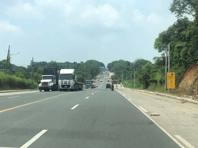 The highway is used by many trucks as there are industrial centers located along the highway including the PNOC in Limay and what used to be called the Bataan Export Processing Zone (BEPZ now the Bataan Freeport) at the end of the highway in Mariveles.
 The widening of the Roman Highway includes the addition of one lane per direction and a narrow shoulder just before the sidewalks. The shoulder could easily be configured into a bike lane but that third lane can easily be designated for bicycles considering the traffic is usually light at most sections of the highway.
 A section where the bridge has already been widened features 3 wide lanes per direction. The shoulders are still there but are not included in the bridge.
 LGUs are joining the No-Contact Apprehension bandwagon
 Another view of the wide highway
More on Bataan roads in a future post. I also took photos of the Gov. J.J. Linao National Road (Pilar – Bagac Road), which is the main access road to the Mt. Samat Shrine.
–
MRT 4 on the way – a monorail along the Ortigas Avenue corridor
I’ve seen and read articles and discussions about the proposed MRT Line 4 along Ortigas Avenue. I’ve written about having a mass transit line along this corridor in the past as it is one of my alternate routes between our home and my workplace. The Line will have the following stations (based on the news articles that came out):
- Taytay – likely at the junction near the Taytay Public Market;
- Manila East Road – likely near SM City Taytay;
- Tikling Junction – major transfer station for those going to Antipolo and beyond;
- San Juan – (future/provisional station) near Valley Golf; will probably materialize when Sierra Valley is completed and occupied;
- Cainta Junction – major transfer station for those heading towards Marcos Highway;
- St. Joseph – likely near or across SM City East Ortigas;
- Rosario – major transfer station for those going to Pasig, Marikina and even Quezon City
- Tiendesitas – (future/provisional station) possible transfer for people traveling along C5;
- Meralco – likely near the Meralco main gate;
- EDSA – likely across Robinsons Galeria and another major transfer station;
- Greenshills – likely across Virra Mall;
- Bonny Serrano – likely near the junction and transfer for people heading towards Camp Crame; and
- N. Domingo – end station connecting to Line 2 at Gilmore.
Following are photos of the current soil test locations for Line 4, all of which are along the eastbound side of Ortigas Avenue Extension between Cainta Junction and Tikling Junction:
 Soil test across the former G-Liner
 Soil test near Brookside
 Soil test before Valley Golf near Mandaue Foam
 Soil test just after the junction with Valley Golf across from the Primark commercial center.
I will not be commenting on Line 4 and its being a monorail at this point. I will probably be writing about this and the idea of having cable cars for Rizal in another post.
–
On university-community collaborations
I’m not a stranger to university-community collaborations. In fact, I even helped draft a proposal for the World Bank to support such collaborations, which I believe would be sustainable and therefore worthwhile to be pursued by potential partner universities and local government units. There are actually many such collaborations but most of these are probably informal with certain faculty members of universities (usually state universities or colleges) being involved in committees or moonlighting in projects implemented or funded by LGUs. I say informal because technically, the school is not involved in the project and it is only incidental that the person or persons involved are affiliated with the university or college.
Here is an article showing an example of university-community collaborations:
National Institute for Transportation and Communities (2022) “Transportation recovery after disasters: A collaborative university/community model,” phys.org, https://phys.org/news/2022-08-recovery-disasters-collaborative-universitycommunity.html [Last accessed: 8/15/2022]
The authors wrote about actions that could be done “to build future economic resilience.” To quote from the article:
-
Increasing pre-disaster investment in resilient transportation infrastructure to reduce the cost of eventual recovery;
-
Improving business resilience practices for high-impact industrial sectors, through education and outreach;
-
Identifying structural barriers to adoption of resilient business practices, and promoting mitigation through recovery.
-
Mainstreaming disaster resilience into economic development by breaking the siloed approach to emergency management and economic development.
While these actions were framed for the community engaged by the University of Utah, they are general enough to be applicable to other communities as well.
I mentioned earlier about the need for formality. The Commission on Higher Education (CHED) encourages and supports what are termed as Extension Works or Extension Projects by higher education institutions. These may be in various forms including committee work, advisory, capacity building/training, or even professional work/services provided to the province, city or municipality (even barangay). But there should be accountability here as well as the proper assignment or allocation of resources.
Just compensation is one of the more sensitive or tricky elements or items here as often, LGUs would like to get something for free or assume that certain services are free. They are not and time and effort should be compensated; just not the international rates you might expect for consulting work from the likes of World Bank or Asian Development Bank.
Here is where contracts (e.g., in the form of Memorandum of Understanding (MOU) or Memorandum of Agreement (MOA)) can be useful to establish the terms of engagement that includes budgets for Personnel Services (PS), Equipment Outlay (EO) and Maintenance and Other Operating Expenses (MOOE). The latter categories should be familiar with LGUs because these are standard items under which details are provided for their programs and projects. State universities and colleges are also familiar with these as standard government terminologies for budgets. Of course, that goes without saying that in certain engagements, there may be third parties such as donor or funding institutions that will should all, most, or part of the costs for collaborative work.
–
