
Home » Land use
Category Archives: Land use
Article share – Planning for Love, Part 3: Enhancing human connection through walkability
Here is the third article that argues for walkability in order to generate human connections. To quote from the article:
“The goal isn’t to design cities for dating specifically, it’s to create places where human connection can flourish. The places we often think of as the most romantic weren’t planned with dating as their primary objective. Instead, their priority was creating vibrant public life, walkability and shared spaces. “
Planning for Love, Part 3: Enhancing human connection through walkability
Source: Planning for Love, Part 3: Enhancing human connection through walkability
Article share – Planning for Love, Part 2: What happens to dating in a car-centric world?
I shared the first part of a series relating the built environment with love (or dating). The second part is also very interesting as it focuses on the impacts of car-centricity. To quote from the article:
“Everyone across both groups said they’d ideally like to meet their partner in person, organically, putting spontaneous public interactions and friends at the top of the list while dating apps and social media fell to the bottom.
In practice, however, drivers were getting far fewer spontaneous public encounters than they wanted, turning to social media for dating far more than they’d like.
For non-drivers, their actual dating life and dating ideals were much more in sync: public encounters and social media use both happened at nearly the rate they preferred. One exception was meeting through friends and family, which happened less often than they would’ve liked.”
Planning for Love, Part 2: What happens to dating in a car-centric world?
Source: Planning for Love, Part 2: What happens to dating in a car-centric world?
–
Alternative reasons for the rise of SUVs in the Philippines
I recently shared an article about the rise of large vehicles in the US and how they have negatively affected road safety in that country. There are mentions there of the elements that led to people preferring SUVs including the usual technical specifications of SUVs and trucks (what they call the pick-up) that proliferate US roads. These are probably safer for transport from the perspective of the occupants including the driver. However, they are unsafe to other road users especially pedestrians and cyclists. I guess the reasons for owning large vehicles are similar for the Philippine case but there are other stories and reasons behind the preference of large vehicles in many parts of the country. A couple of these are quite common reasons that has nothing to do with people having car-centric mindsets. The latter is probably far from their consciousness.
One reason for preferring larger vehicles is practicality. I first encountered this reason during vacations in Iloilo in the 1970s and 1980s. People had pick-ups and owner type jeeps built for the rough roads at the time. Cars would not have survived the road conditions with the shock absorbers and tires being the first to go. This would probably be the same reason in other provinces as well. The unpaved and poorly maintained roads necessitated pick-ups and the SUV models of those times. Eventually, these evolved into the Pajeros, Patrols and Land Cruisers and later the Monteros, Everests and Fortuners. Add to these the AUVs (e.g., Innova, Adventure, etc.) that also became preferences depending on the affordability to people.
Another reason for preferring larger vehicles is not just about practicality but survival. People from flood prone areas tend to have larger or taller vehicles. Ground clearance is a criteria for vehicles as these have to be able to navigate flooded highways and streets. Most flash floods are probably ankle or gutter deep. But there are more severe situations where floods can be knee or waist-deep. And so people preferred vehicles that can get them out of their flooded homes if not get to their not flooded home but via flooded roads. This comes from first hand experience. After Typhoon Ondoy inundated much of Mega Manila, sales of SUVs and AUVs were up. People replaced their vehicles with these rather than regular cars. They generally didn’t transfer homes as many decided to stay as they probably couldn’t afford to get a new hour or have gotten used to the flood situation in their places. Floods, after all, are seasonal and the Ondoys are not so frequent.
The stories or reasons I cited above are real and will probably be attested to by many who share the experiences in flood-prone and/or rural areas. These narratives though have been set aside or dismissed in favor of the car-centric narrative that’s the in thing these days. If we really look more deeply, the failures of infrastructure development, whether pertaining to basic roads or drainage systems, have tremendous impacts on our lives including our preferences for vehicle types or models. In fact, weren’t those also among the questions for resisting electric vehicles? Kaya na niyan ang rough roads? Kaya ba niyan ang ahon? Kaya ba niyan ang baha? Of course, housing location preferences and options (along with affordability) are also factors. Why live in a flood prone area after all? But that’s another topic that I plan to write about as well very soon. I think I wrote something about this here or in my other blog. I should write about it again and probably in light of the flood control projects that have been the hot topics these past months.
–
Article share: Why Complete Streets Design Benefits Everyone
Here is another quick share of an article; this time on Complete Streets. I guess many are aware of the AI-generated street transformations that are now being shared across many social media platforms. These show street transformations of many sections and intersections.
Source: Why Complete Streets Design Benefits Everyone
Again, it is important to have context sensitive solutions. This extends to street transformations. Some may look cool (AI tools have enabled non-architects, non-engineers, etc. to produce nice renderings) but should be tempered for the street or highway functions as well as the actual volume of people and vehicles running along these.
–
A cityscape revisited
I was posting photos of a familiar sight along one of my walking routes in our neighborhood. Somehow, that route became less frequented as houses were constructed in what old timers here referred to as the second floor. What offered a 360 view of areas surrounding our place was now mostly inaccessible, depriving people of spectacular views.
Last Sunday, we chanced upon the sight below along another of my routes that we now seldom passed.
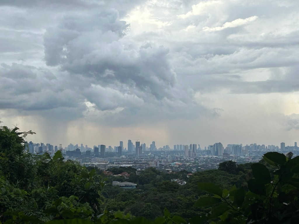
The place where I took the photo will probably also be inaccessible soon as we saw the lots being cleared for construction. We missed the views and soon they’ll be just memories or photos stored in our gadgets.
–
Aerial photos – reclamation projects in Manila Bay
Last week’s travel allowed me to take aerial photos of the reclamation projects in Manila Bay. Here are the photos:
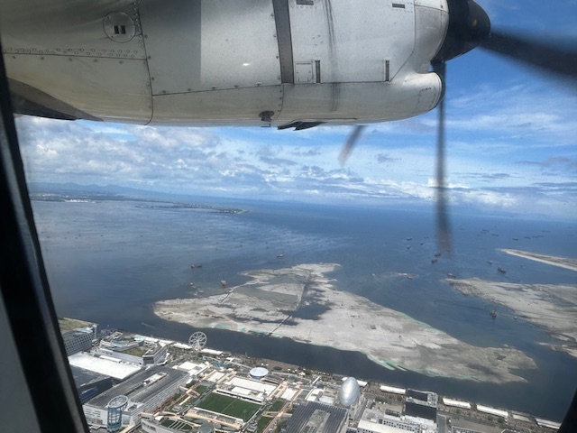 The view as we lifted off from NAIA shows SM’s reclamation project across from the MOA complex.
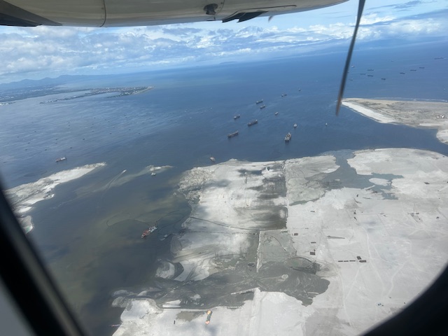 Our plane then climbed and afforded this close-up of sorts of the reclamation across from the now closed Sofitel Hotel.
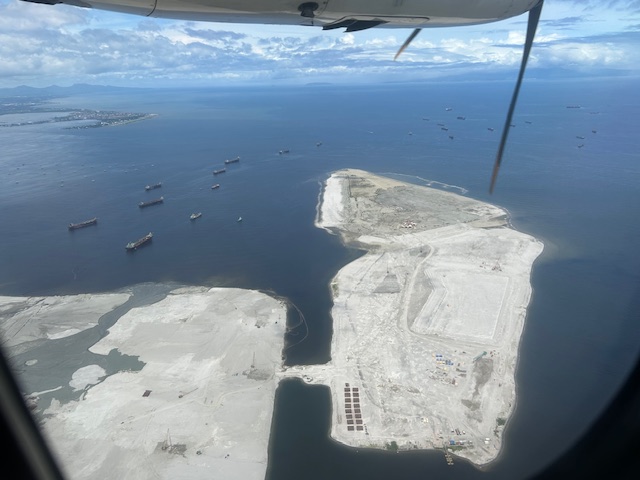 Past the largest of the three reclaimed lands is another man-made island.
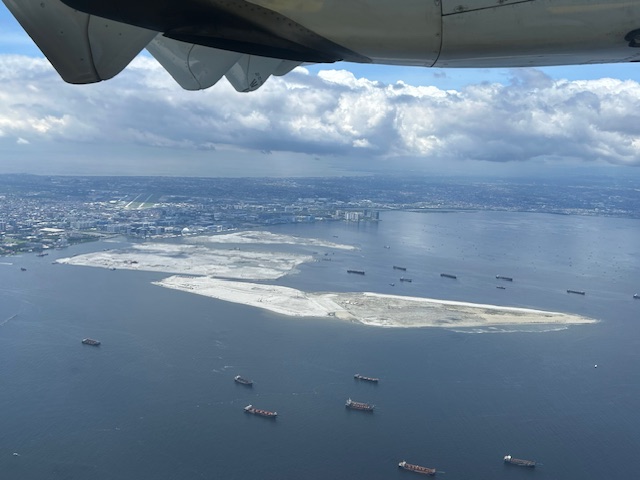 As our plane turned left, we were able to see all three reclamation projects
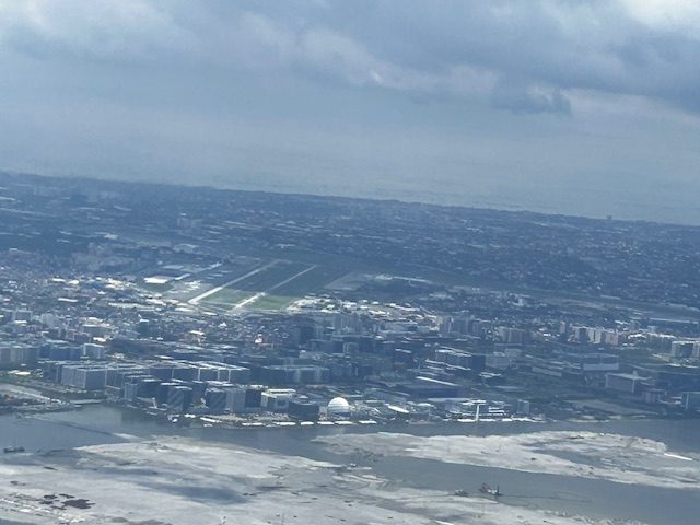 A close-up of the reclamation across the MOA complex. Also in the photo is NAIA.
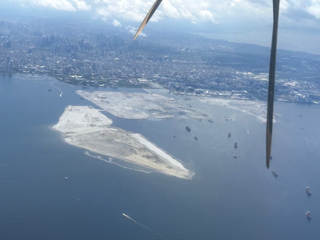 All three reclamations in one photo as we continued to turn towards the south and southeast (towards Bicol).
More aerial photos soon!
–
Article share: on improving road safety in the midst of automobile dependency and sprawl
I am sharing another very informative article on road safety. While it is written for North American cities, most concepts and principles presented are applicable elsewhere and especially in cities and municipalities that tend to model their development after America. Increasing dependence on private vehicles (not just automobiles but including motorized two and three-wheelers) have resulted in increasing incidence of road crashes and though we have limited space, we tend to develop land as if we can afford sprawl and its consequences. Here is the article:
Litman, T. (April 25, 2025) “End Human Sacrifices to the Demanding Gods of Automobile Dependency and Sprawl,” Planetizen, https://www.planetizen.com/blogs/134838-end-human-sacrifices-demanding-gods-automobile-dependency-and-sprawl?utm_source=Planetizen+Updates&utm_campaign=d3fcb4d16b-newswire_05_05_25&utm_medium=email&utm_term=0_-6cce27a957-89144212&mc_cid=d3fcb4d16b&mc_eid=9ccfe464b1 [Last accessed: 16/05/2025]
To quote from the article:
“North American transportation agencies currently apply various older strategies, which should not be ignored, but to achieve additional crash reductions they need new strategies, such as those listed in the following table. The older strategies are targeted programs applied after most major transportation and land use planning decisions are made. New strategies include structural reforms involving more multimodal transportation planning, more compact development, transportation demand management incentives and parking policy reforms. This recognizes that all types of planning decisions affect transportation safety, and that many policies can increase safety in addition to other economic, social and environmental benefits.
The new paradigm expands traffic safety strategies to include structural reforms that increase transport system diversity and efficiency. They tend to provide many economic, social and environmental benefits in addition to safety.”
–
On walkable spaces for senior citizens
Here is a quick share of an article on walking and walkability, and the relation with dementia:
Steuteville, R. (March 10, 2025) “Living in a walkable place reduces dementia,” , https://www.cnu.org/publicsquare/2025/03/10/living-walkable-place-reduces-dementia [Last accessed: 3/29/2025]
To quote from the article:
“When we live in a walkable place, we move more, naturally. Unsurprisingly, exercise is linked to better cognitive health. Regular exercise increases memory, and boosts hippocampal volume by 2 percent.
Also, walkable neighborhoods are more stimulating. They are built on connected street networks, which give individuals more choices on how to get around and reward those choices with diverse physical paths linked to spatial memories. And they are mixed-use.
“Street layouts with better connectivity and walkability are associated with a reduced risk of cognitive impairment. Access to local amenities, such as food stores, community centers, and healthcare amenities, supports cognitive health,” the authors note.
Social connections also probably help. When you walk to a destination, you are more likely to have friendly interactions, which have been shown to reduce the risk of depression, and walkable places also boost the sense of community.”
As there are many senior citizens in our village, the topic is quite relevant. Most seniors probably won’t take a walk if they felt it was dangerous or risky even inside residential subdivisions. In our neighborhood, there are a few of them going around using their motorcycles or scooters. Most I see walking around perhaps for exercise or leisure rather than to go to a store or restaurant in the area. But increased traffic due to customers of restaurants that sprouted around the village has increased the risk for those who walk. Hopefully, the induced motor vehicle traffic generated by these establishments can be managed and regulated for the overall welfare of residents.
–
On C-6 and the proposal for another expressway, Part 2
The recent announcement and launch of the Southeast Metro Manila Expressway (SEMME) included this map showing the (very) rough alignment for the proposed tollway. The map also shows the proposed locations of interchanges including one in Tikling and another in Masinag. There is also another in Tumana. From the looks of this, the SEMME will be a skyway or elevated expressway/tollway.
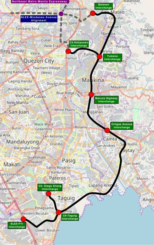
My first impression is that this elevated tollway will pass through predominantly residential areas with columns rising from private subdivisions. It doesn’t help that the topography also means the columns will be built along hilly or mountainous terrain, thereby making construction more challenging than the elevated tollways in Metro Manila.
Do we really need another circumferential road and particularly another tollway? I think that is a very important question that not only needs to be asked but also answered the right way. I, for my part, don’t believe we need another tollway, elevated or not, as this will not solve the so-called traffic problem. In fact, it creates more problems than what is supposed to be solved with the induced traffic this will generate and its promotion of car-centricity. For the price and effort of such an infrastructure, you will get more bang for your buck with a mass transit line or lines. Road congestion can only be solved by constructing the public transport system we needed decades ago.
–
On affordable housing
I’ve written about the relationship between transportation and housing in many of my previous posts. Here is an article defining affordable housing from the US context:
Axel-Lute, M. (January 23, 2025) “What is ‘affordable housing’?” Shelterforce, https://shelterforce.org/2025/01/23/what-is-affordable-housing/ [Last accessed: 2/4/2025]
To quote from the article:
“With no other qualifications, “affordable housing” in the United States typically refers to housing whose cost is affordable to households that make somewhere between 40 and 80 percent of the area median income.
Below 80 percent of AMI is how the U.S. Department of Housing and Urban Development officially defines “low income”—but be careful about making assumptions. Area median incomes are calculated at the metropolitan level, so for many areas they can be quite high. In those cases, “affordable housing” might be targeted to people who wouldn’t have considered themselves low income.
On the other hand, in some less affluent neighborhoods, official “affordable housing” might be too expensive for most of the people who already live there. And in metropolitan areas with lower housing costs overall, official “affordable housing” might not be much cheaper than market rate!”
How do we define affordable housing in the Philippines? Is our definition of “low income” similar to how they define it in the US or elsewhere? Or are our definitions flawed and therefore affect how we provide (or not) housing to those who need them the most?
–

