
Home » Public Transport (Page 25)
Category Archives: Public Transport
New public utility vehicles in Cebu
There have been a lot of new models of vehicles serving as public transport in Metro Manila. It came as no surprise that we found similar vehicles (e.g., Beep or modern jeepneys as some people refer to them) as well as buses in a city that was supposed to have had the first operational Bus Rapid Transit (BRT) line in the country. Sadly, the Cebu BRT has not been constructed and now national government agencies and the local government is mulling a light rail transit system instead. Here are some photos of the Beep vehicles operating in Cebu as well as a couple of bus services.
 Beep mini-bus beside an old jitney – the vehicle sizes are comparable but the Beep capacity is larger. The Beep is also air-conditioned and features a layout similar to buses.
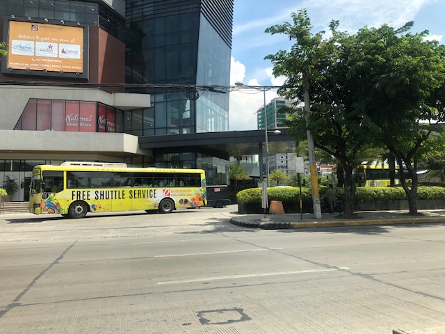 Free shuttle bus service provided by Robinsons Malls
 Beep serving the City Hall – IT Park route
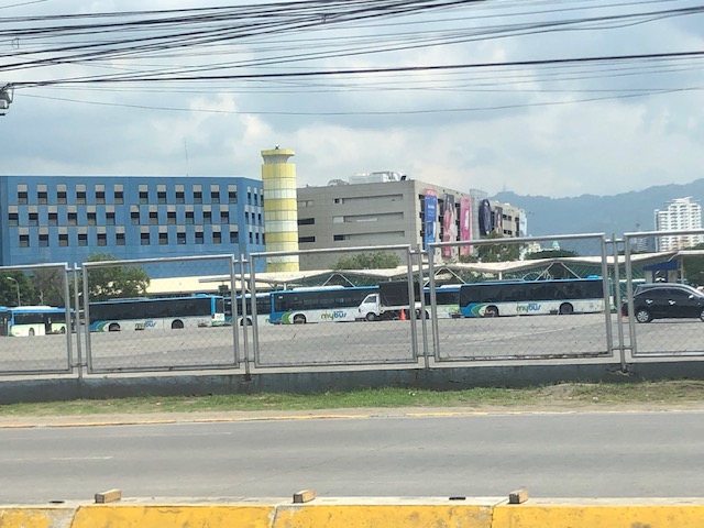 MyBus depot at the SM City Cebu North Reclamation Area – these are currently plying the route connecting SM City Cebu with SM Seaside. The route is actually one that was considered for a pilot Bus Rapid Transit (BRT) line – supposedly the first one in the Philippines – that did not come into reality.
–
Another look at the Mactan Cebu airport taxi stands
This is the last of three posts about our recent arrival at Mactan Cebu International Airport. Following are more photos; this time from exiting the terminal building to the transport stand and driveway.
 Arriving passengers exiting the Terminal 1 building and heading to the driveway for transport
 Directional signs for various road transport options at MCIA. These include metered taxi, white taxi (airport taxi) and bus
 The driveway also includes bays for private vehicles. These are mixed with rideshare vehicles such as those with Grab.
 Metered taxi stand – there used to be a Grab booth here but I couldn’t find them in the area so either they might have set up somewhere in the airport or perhaps it is assumed that people can manage with their apps on their smartphones.
–
Why more low capacity PUVs?
I’ve written about the recent additions of new (the government I think prefers to call them ‘modern’) model jitneys along corridors like Marcos Highway, C-5, Quezon Avenue, Espana Avenue, etc.). My main comment has always been about the capacities of these vehicles considering the high transport demand along these routes where the Department of Transportation (DOTr) and the Land Transportation Franchising and Regulatory Board (LTFRB) have authorised these so-called “experimental” routes. The services actually overlap with existing lines of other PUVs like jeepneys, UV Express and buses. Their value is apparently the single, direct ride they provide to commuters, who otherwise would have to transfer vehicles to get to their destinations. The popularity of these “experimental” services only underlines or emphasizes the need for rationalising transportation services especially in Metro Manila.
There are surely opportunities to improve the network including those taking advantage of the improvement of rail services. But rationalisation is not just about changing routes. It also means determining the right capacity vehicles for these routes. Thus, high demand corridors require higher capacity modes in terms of both vehicles and their frequencies. Perhaps authorities should look into the examples of P2P bus operations as a way of determining the type of vehicles to be deployed as part of the so-called experiment rather than appear to be just promoting these modern jitney models. PUV modernisation, after all, should also mean upgrading the existing vehicles servicing certain routes by replacing them with ones that are more efficient and with higher passenger capacities.
 This mini-bus lookalike has a capacity of 23 passengers. That’s practically the same as the newer model jeepneys that are generally longer and with some cleverness of the driver and conductor may seat more (i.e., Benches placed inside the jeepney increases their seating capacity. This set-up, however, is unsafe.)
–
Evidences of demand for Line 2 beyond Masinag (again)
My commute between my home and office usually takes me to Masinag where I make the choice between traveling via the typical Marcos Highway route or via the alternative Marikina/Tumana route. Here is a scene that I usually see whenever I pass by the informal UV Express terminal just past the Masinag junction along the westbound side of Marcos Highway and just before the Decathlon sports facility currently under construction.
 Passengers waiting for UV Express vans or AUVs to return around 8 AM. The latter serve the Cogeo – Makati (Greenbelt) route, which could take 2 or 3 rides using other modes of public transport (e.g., one ride to Cubao and another from Cubao to Makati)
Note how many people cannot get a ride around 8 AM. If only there were more efficient options then these people would likely take them but for now the obvious and practical choice for them is the UV Express. Others, of course, can just walk further to SM Masinag where there is a P2P bus service also heading to Makati. Recently, a new “experimental” route was opened between Cogeo and SM Aura in Taguig using modern jitneys.
Once completed, Line 2 should be able to provide an alternative for these commuters but there is still the issue of a seamless transfer in Cubao. There is no direct connection between the Line 2 and Line 3 stations with the former connected to the Gateway Mall while the latter is connected to Farmers. That is a significant walk between the two stations.
But where do the commuters in the photo come from (origin?)? Most likely don’t reside around Masinag Junction though there are many residential area around this location. Many are ferried here by tricycles, jeepneys or private vehicles. Many likely have their own cars but opt not to drive to/from Makati. That is actually a good thing and something that needs to be sustained rather than give a reason for these people to use cars for their commutes. And so there is a need to extend Line 2 perhaps to Cogeo, and a branch to Marikina. The Marikina branch, as I’ve mentioned before, could terminate at the Marikina Sports Center. Meanwhile the extension to Cogeo should not stop there but continue further towards Antipolo’s new government centre. This corridor’s population is steadily increasing and the transport demand must be addressed not by low capacity modes but by a mass transit system. The low to medium capacity modes should be in support or at most supplementary to the high capacity system with the Line 2 as backbone.
–
Snapshots on a Zamboanga trike
I like taking photos from the vehicle when I’m traveling. It doesn’t matter whether I am on a car, on a bus or even a motorcycle as long as it is safe and there’s no danger of dropping my camera or my phone. Here are a few photos taken as we were on a tricycle in Zamboanga.
 Old building on a corner of a street in Zamboanga showed how buildings in the downtown area were built. The ground floor is likely a shop, store or office while the upper one is likely to be a home. From the photo, it becomes obvious that pedestrians were protected against the elements (sun or rain) for this arcade type of development.
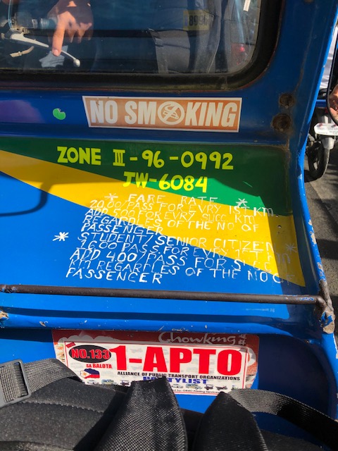 Inside the tricycle, the fare rates are printed on the side car. That includes the discounts that are supposed to be given for senior citizens and students.
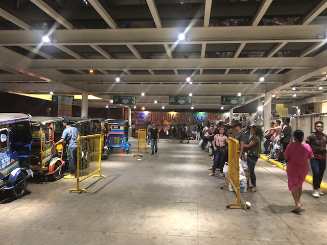 At the transport terminal of a major mall in the city, the lines are long for taxis. However, there are few taxis serving the city and the usual mode of transport that are basically 3-wheeler taxis (the tricycles) wait for passengers.
 Sign warning against abusive tricycle drivers who overcharge their passengers. There are penalties including a fine of 4,000 pesos (about 80 USD).
I will post more photos of Zamboanga scenes next month when we head to Zamboanga for some field work. That will give me the opportunity to take a lot of photos as we make an initial assessment of road safety around selected schools in the city.
–
On improving public transport services to increase or retain ridership
Here is another quick post; sharing a nice article on how to improve public transport services:
Miller, A. (2019) “From the Bus Stop to the Fast Lane: How Cities Can Speed up Buses, Improve Ridership”, Medium.com, https://medium.com/frontier-group/from-the-bus-stop-to-the-fast-lane-how-cities-can-speed-up-buses-improve-ridership-f96d473c1cc7 [Last accessed: May 4, 2019].
While the article drives the point towards increasing ridership, I think the challenge for Philippine cities is more of retaining ridership. This is because there is pressure of public transport ridership decreasing as a result of increasing car ownership (owning their own vehicles is still an aspiration among many Filipinos), the popularity of car sharing/ride-hailing, and the still rapid increase in motorcycle ownership.
–
On unlocking the potential of shared transportation
Here’s a quick share of a very nice article that’s very informative and therefore useful to people seeking to tap into the potential of shared transportation to help alleviate transport woes in their cities and towns:
Miller (2019) “9 Ways Cities Can Unlock the Potential of Shared Transportation”, Medium.com, https://medium.com/frontier-group/9-ways-cities-can-unlock-the-potential-of-shared-transportation-66a53b2c841 [Last accessed: May 3, 2019]
So far, we only have few examples of shared transportation in the Philippines. These include a few bike shares in Metro Manila and does not count ride-hailing/ridesharing, which we now know is not really a sustainable form of transport.
–
Public transport coverage in Metro Manila
I saw several posts circulating on social media about public transport routes in major cities that included stylised maps presented like the transit maps you usually see for cities like Tokyo, Hong Kong and Singapore. These show what the makers identify as the equivalent of stops or stations along the public transport “lines”. These, of course, are a simplification because what appears as a single line may actually be comprised of several. Also, the overlaps seem to be also quite simplified compared to what may be found in reality. This post will not attempt to show how complicated road public transport is for Metro Manila. Instead, I am sharing the maps prepared from a previous study we conducted for the then DOTC (ca. 2012) that show the coverage of three road public transport modes: buses, jeepneys and UV Express.
 PUB coverage for Mega Manila with distinction of EDSA and non-EDSA routes (2012)
 Jeepney route coverage for Mega Manila (2012)
 UV Express route coverage for Mega Manila (2012)
I hope these maps have already been updated or are going to be updated in order for us to have good visual references for public transport planning including the identification of locations for integrated terminals as well as connections with rail transit.
–
On the Holy Week rush and long distance trips
It’s that time of year again when people travel a lot of mostly to go back to their hometowns to spend the Holy Week break there. Many will also be going on leisure trips; heading to tourist destinations such as beaches, which are likely the most attractive places during this sweltering summer season. Most people will likely travel on land and would be taking public transportation in the form of provincial buses (while there will be more cars on the roads, more people will be on high occupancy vehicles).
 Provincial bus terminal near the end of Gil Puyat Ave. (formerly Buendia Ave.)
One wonders if the mode shares for these provincial trips could have been different at least for Luzon Island if the old PNR northern and southern lines were retained, maintained and modernised. What used to be the Main Line North stretched all the way to San Fernando, La Union with stations at most major cities and towns in Bulacan, Pampanga, Tarlac and Pangasinan including Malolos, San Fernando (Pampanga), Angeles City, and Dagupan City. Meanwhile, the Main Line South stretched all the way to Legazpi City in Albay with stations in the provinces of Laguna, Quezon, Camarines Norte, Camarines Sur and Albay. These included stations in Calamba, Los Banos, Sta. Cruz, Lucena and Naga. Surely, more people would have taken the trains for these long distance trips if the rolling stock were a lot like those operation by Japan Railways?
–
More irrational public transport?
I spotted a new vehicle serving a new route between Cogeo in Antipolo and SM Aura in Taguig. I see these vehicles along Marcos Highway from Masinag to Santolan. Friends have spotted the same along C-5 at Eastwood and at Tiendesitas; confirming the route this mash-up between the jeepney and bus is running along. The route overlaps with existing public transport lines along Marcos Highway (mostly jeepneys connecting the eastern cities and towns with Cubao) including the elevated Line 2.
 Jitney running along Marcos Highway in Antipolo (section between Masinag and Cogeo)
The jeepney has a sign stating it is a DOTr project. So is this an experimental run to determine the viability of the route in place of the traditional approach using what was termed as RMC (Route Measured Capacity)? I am not aware of any other ways by which the DOTr or the LTFRB are able to estimate the number and type of public utility vehicles to serve certain routes. There are, however, initiatives to open what they call “missionary routes” but this term used to refer to really new and unserved (referring to formal public transport) corridors or areas rather than those that are already being served by several modes of public transport. The results of this interpretation of “missionary routes” are more overlapping routes that further complicate and undermine efforts for rationalising or simplifying public transport services in the Metro Manila and other cities as well.
I will soon post here three maps showing the public transport route coverage for Metro Manila more than half a decade ago. These show the coverage of buses, jeepneys, and UV express services at the time. I now wonder how these would look like with the new routes overlayed unto the maps.
