
Home » Public Transport (Page 7)
Category Archives: Public Transport
‘Modern’ jeepneys in Cebu
The jeepney is actually a jitney, a paratransit mode with a capacity between the bus and the mini-bus. Jitneys are quite popular in developing countries like those in Southeast Asia and Africa. In the Philippines, the jeepney evolved from the American Jeeps left by US Forces after World War 2 that were customized in the style of the auto calesas that developed before the war.
With the government’s public transport modernization program, there are now many so-called ‘modern’ jeepney models operating around the country. The following are photos I took while doing fieldwork in Mandaue City.
 Many modern jeepneys are actually mini or micro buses like the one in the photo. They did not retain or adopt the look of the conventional jeepneys. This one is a model by Japanese automaker Hino. The one behind is another jitney form – a multi cab.
 Another modern jeepney / mini bus model manufactured by another company. I have to check which company given the emblem in front of the vehicle.
 Another Hino vehicle but by a different operator as evident in the livery.
 Another mini bus model

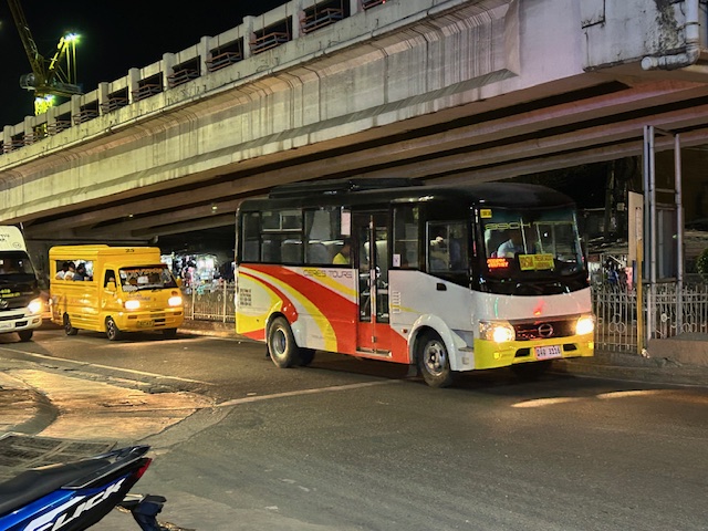
 A low floor bus operated by Ceres, a major bus company in the country that also operates RORO buses.
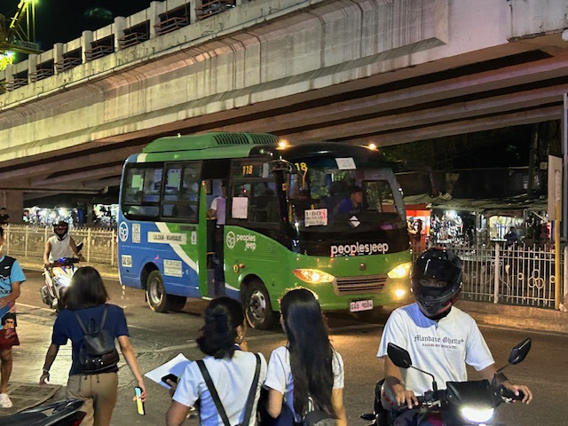
 Another modern jeepney model operated by another coop in Mandaue.
 Star 8 jeepneys are also operating in Mandaue City. I first saw these in Tacloban City many years ago. They were supposed to be able to recharge via solar panels installed on the roof the vehicle. That should allow them to replenish power while running. These days, we do have a lot of sun so the only question is whether the solar power feature is functional.
–
Planning for Accessibility: Proximity is More Important than Mobility
Here is a quick share of another very informative article that discusses the importance of proximity and more dense development in order to reduce car dependence.
Source: Planning for Accessibility: Proximity is More Important than Mobility
Here are some excerpts from the article:
“This shows that proximity is much more important than mobility in providing accessibility: location, location, location. For the last century, our transportation planning practices have contradicted this principle. Transportation agencies built urban highways that destroyed and degraded accessible and multimodal neighborhoods to benefit suburban motorists. This was racist and classist, but the mechanism was the way that transportation planners valued increased traffic speeds, measured as travel time savings, while ignoring the loss of accessibility imposed on urban neighborhood residents.
Of course, many other factors affect people’s transportation and neighborhood preferences. Some people need their cars for work or after-work activities, and not everybody can bicycle or use transit even if it is available. However, surveys such as the National Association of Realtor’s National Community Preference Survey indicate that many people would prefer living in more compact, walkable neighborhoods than they currently do but cannot due to a lack of supply.”
Such articles are a must read for those who want to understand why government needs to invest in land at or near the CBDs, and develop that land so people will not need to reside far from their workplaces and schools. Truly, there are many other factors affecting transport preferences or mode choice. Housing is one such factor that we continue to treat separately from transport. It is very (prohibitively) expensive to buy or rent in the city particularly in or near the CBDs. The result is people opting to purchase or rent homes in the suburbs. It doesn’t help that developers are also actively promoting subdivisions there and therefore are contributing to sprawl that puts so much pressure on transportation systems.
–
Taxi services at NAIA Terminal 2
The previous post on NAIA Terminal 2 featured photos of taxi or ride share services at the airport. Coupon Taxis are the most expensive option for travelers as they have the highest rates. Often, these are even higher than vehicle rental rates. These rates are shown to prospective customers though so I can’t really understand why people go for this option and then slam it for being expensive. The information is provided there so accepting the terms means you understand and accept the rates. Perhaps they didn’t have other options?

There is a Grab stand at the terminal. I assume that since Grab is quite popular at least in Southeast Asia (even taking over Uber’s share), then travelers who likely have smart phones should have the app and be able to book a ride using it. This might be the best option for those on the go.

There is also a regular taxi stand at the airport terminal so that is another option. Unfortunately, one will likely have to haggle with the drivers for the fare. Other drivers might use their meters but will suggest or solicit tips from their passengers.
There is no rail service for the NAIA Terminals but there is an airport bus, UBE Express, that travelers can take to go to major CBDs like Cubao, Ortigas and Manila or perhaps to major terminals like PITX or the Victory Liner Terminal in Pasay City.
–
Article share: on subsidies to public transportation
Here’s a nice article that presents arguments for subsidies to support transit or public transportation:
Wilson, K. (February 5, 2024) “Study: Subsidizing Transit Actually Makes It More Efficient,” Streets Blog USA, https://usa.streetsblog.org/2024/02/05/study-subsidizing-transit-actually-makes-it-more-efficient [Last accessed: 2/18/2024]
Subsidies to public transportation can be quite tricky and may require quite a balancing act. There seems to be few options outside of the straightforward subsidies national and local governments in the Philippines provide. Rail transit, for example, is heavily subsidized but these are rare for road-based public transportation. The concept of service contracting has been considered but it also has a few variations. While there seems to have been a proof of concept tested during the pandemic, it required so much funds that government apparently lost interest (i.e., the funds were also needed by other sectors). Local governments meanwhile, or at least those that had resources, decided to operate their own public transport (e.g., Quezon City bus).
To quote from the article:
“Newmark’s study doesn’t definitively determine why, exactly, high subsidies seem to correlate with better efficiency and transit agencies collecting more fares, but he has some theories. Some systems, he says, use subsidies to increase service frequency or install dedicated lanes to speed routes up along heavily-utilized corridors — and riders are responding, predictably, by showing up in droves. (Route expansion can help, too, he said, but only if agencies expand service to places “where there’s actual demand.”) Others use subsidies to keep ticket prices low, but not to eliminate fares outright, which Newmark argues is a smart move.
“People value stuff they pay for, and they pay for stuff they value,” Newmark added. “An underlying point in this paper is that transit offers something [valuable], and it’s worth trying to capture that value, whether through fares or in other ways.”
If transit networks and the taxpayers who support them can get that recipe right, it could create a virtuous cycle.
“If people see the benefits [of subsidies], that may make them more willing to invest [their taxpayer dollars],” he adds. “Good transit leads to a real social movement for more subsidies.” “
What do you think about subsidies to public transport in the Philippine setting? Of course, we are referring to ‘formal’ public transportation here. There are many ‘informal’ or paratransit modes like tricycles and non-motorized pedicabs. There are also motorcycle taxis providing services or filling in the gaps in transport services.
–
Congestion near bus terminals during the Christmas season
I attended a formal event yesterday at the Philippine International Convention Center (PICC) in Pasay City. Along the way and back, I already noticed the congestion along Gil Puyat Avenue (formerly Buendia Avenue) as well as the congestion or how crowded the bus passenger terminals were. In fact, the buses at the JAC Liner terminal along Gil Puyat were all on the streets. The terminal itself was filled with passengers, many of whom were queued as they waited to board their buses. Others I assumed were in line to purchase tickets there. The latter apparently have not done so online, which is already an available and more convenient option for provincial travel.
 |
| Buses lined along the Makati-bound side of Gil Puyat Avenue. These are queued towards to the U-turn slot that will take them to the bus terminals on the other side and near Taft Avenue. |
 |
| Other buses are lined along the Pasay-bound side of Gil Puyat Avenue. These come from the South Superhighway where these buses eventually head to after boarding passengers en route to Southern Luzon, Bicol and even Visayas and Mindanao destinations. |
Then as now, the junction of Gil Puyat and Taft Avenues is a major convergence area for transportation especially provincial routes. Even before the construction of the LRT Line 1 (which has a station at Gil Puyat) there have been a number of bus terminals here. Currently, I am aware of the JAC Liner and DLTB bus terminal near the junction. There are others including small terminals or garages for provincial buses. These generate much traffic particularly during this Christmas, which is considered peak season for travel in the country.
–
On micro transit covering for regular public transport services
I am sharing this very interesting (to me) article on microtransit making up for the conventional public transportation:
Zipper, D. (December 19, 2023) “On-Demand Microtransit Can’t Escape This Big Problem,” Bloomberg, https://www.bloomberg.com/news/articles/2023-12-19/the-inflexible-problem-with-flexible-microtransit?utm_source=website&utm_medium=share&utm_campaign=copy [Last accessed: 12/22/2023]
To quote from the article:
“Fixed-route service on large buses also offers the economies of scale that microtransit lacks. As long as empty bus seats are available, each new rider brings new revenue to the transit agency while incurring minimal added costs, thereby reducing the subsidy required for each trip. Public dollars can then be reallocated to expand service, which will make transit more useful, thus attracting more riders — and the virtuous cycle continues.
For microtransit, that flywheel effect is missing; the cost of service keeps rising as more people use it. “It would be great to have anywhere-to-anywhere connectivity for the price of transit,” said Goldwyn. ”But it’s just not possible.””
I think this article also touches on motorcycle taxis though perhaps there are also differences between the western and Asian contexts for micro mobility. Surely though, such transport modes cannot approximate transit capacities and require so many more vehicles (e.g., motorcycles) that probably means more chaos and compromised safety along our roads.
–
29th Annual Conference of the TSSP
The Transportation Science Society of the Philippines (TSSP) held its 29th Annual Conference today, December 7, 2023. Following is the program for the conference, which featured a panel discussion in the morning and technical sessions in the afternoon.
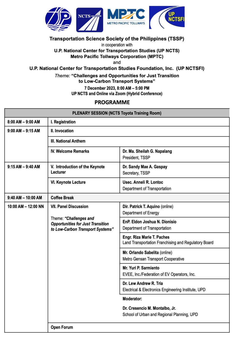
This was the first mainly face-to-face or in-person conference for the society since 2019. Previously, the conferences were online. As reported in the concluding part of the program, there were 84 participants who showed up at the venue while there were 30+ participants who were online via Zoom.
There were a couple of awards at the conference. These were the Best Paper Award and the Best Presentation Award. The Best Paper Award, based on the scores garnered from the blind review of the papers went to:
Maria Belen Vasquez and Jun T. Castro of UP Diliman for their paper entitled “Exploring Travel Patterns of Mobility of Care in Guiuan, Eastern Samar: Assessment of Gender and Sociodemographic Factors Using Spatial Analysis”
There was a tie for the Best Presentation Award. The two were Ms. Vasquez for the presentation of the paper on the Mobility of Care in Eastern Samar, and Mr. Erris Sancianco for the presentation of a paper he co-authored with Noriel Christopher Tiglao, Niki Jon Tolentino, Gillian Kate Hidalgo, Mary Joy Leanda, and Lester Jay Ollero entitled “Evaluating the Fuel Efficiency and Eco-Driving Potential of the EDSA Carousel using On-Board Diagnostics (OBD) and Mobile Crowdsourcing“. These papers will likely find their way to the Philippine Transportation Journal’s next issue.
Though it was not announced, a likely venue for the next conference will be Vigan, Ilocos Sur in the Northern Philippines. The likely host will be the University of Northern Philippines, the premier state university in that province. Previously and most recently, the conference was held in Cebu City (hosted by the University of San Jose-Recoletos) in 2019 and before that in Cagayan De Oro City (hosted by Xavier University) in 2018. TSSP was already organizing the 2020 conference when the pandemic struck and the country went on a lockdown. That conference was supposed to have been held in Baguio City in Benguet, and to be hosted by St. Louis University.
More information on the conference may soon be found at the TSSP’s official website: https://ncts.upd.edu.ph/tssp/
–
Are transport strikes still effective?
There is supposed to be a transport strike today, after one group, Manibela, declared what they dubbed as a nationwide strike to protest versus the perceived jeepney phase-out and alleged corruption at the Land Transportation Franchising and Regulatory Board (LTFRB). I used the term ‘perceived’ to describe jeepney phase-out because what is actually unfolding or being processed is a rationalization of public transport services. There is also a modernization program where old jeepney units are supposed to be retired and replaced by vehicles that are low emission and higher capacity, among other characteristics. Perhaps one flaw, if you can call it that, is that the new vehicles look nothing like the conventional jeepney. They look like vans and buses. And so somewhat lost here is the classic image of the jeepney, which was heavily influenced by the old WW2 American Jeeps that were the base units that eventually became jeepneys.
 This does not resemble a classic jeepney
Fast forward to present and another declared transport strike fizzled out. It turns out that most transport groups did not want to take part for one reason or another. DILG Secretary Abalos even met with the heads of the more established groups and stated that 95% of jeepney operators and drivers will not join the strike. As many LGUs and schools already anticipated the potential impacts of a strike, they already suspended classes and reverted to online work (WFH) and study modes. In previous occasions, LGUs were prepared with a “Libreng Sakay” (free ride) scheme. That meant most people being able to get rides to go to work, school or home. Transport strikes now seem a thing of the past and further into the future, I don’t think they would be an option. The general public see these more as an inconvenience, and social media and a misinformation/fake news machinery at the employ of those in power means a transport sector with legitimate issues will be demonized.
–
Reference share – study on transport equity
Here is a quick share of a study report on equity in public transportation from the Mineta Transport Institute:
Defining and Equity in Public Transportation, https://transweb.sjsu.edu/research/2100-Public-Transit-Equity-Metrics-Measurement
Perhaps income, physical ability/disability, age and gender are the more applicable aspects of equity in our case. However, the concepts and methodology in the report may still be applicable and can be customized or contextualized for the Philippine setting.
–
On micro mobility use of low-income people
We conclude September 2023 with another article share. This time it is about how low-income people use micro mobility.
Wilson, K. (September 20, 2023) “Study: How Low-Income People Really Use Micromobility,” StreetsBlog USA, https://usa.streetsblog.org/2023/09/20/study-how-low-income-people-really-use-micromobility [Last accessed: 9/30/2023]
To quote from the article:
“Low-income people are using shared micromobility a lot like they use public transit, a new study finds — and researchers think cities should thoroughly embrace (and subsidize) the mode as part of the larger ecosystem of buses and trains.
Researchers at Monash University, using survey data from micromobility giant Lime users across all income levels in the U.S., Australia, and New Zealand, dug deeper into how low-income people uniquely use the company’s vehicles.
Participants in the Lime Access program, which grants discounts of around “70 or 80 percent” to riders who qualify, were significantly more likely to list essential reasons like “shopping” for groceries (35 percent) and “commuting” (31 percent) than non-Access riders, 11 and 21 percent of whom rode to complete errands or go to work, respectively.
The discount recipients were also highly unlikely to go use bikes and scooters for non-essential reasons like social outings (12 percent), “joy-riding” (9 percent) or exploring (2 percent), quashing the stereotype that all micromobility trips are spontaneously generated. And a whopping 44 perccent of their trips connected to a traditional transit ride, compared to just 23 percent of people who paid full price.ago
Perhaps the most surprising findings, though, were riders’ qualitative responses about what micromobility meant to them, and how their lives were made better by having access to affordable ways to get around without a car. Calvin Thigpen — director of policy research for Lime and co-author of the report — says he was particularly moved by the number of riders with invisible disabilities who said Lime Access helped them get where they needed to go, even when local transit schedules didn’t meet their needs.”
The study was made in the First World (i.e., US, Australia and New Zealand) so while the methodology is sound, the subjects (i.e., what they defined as low-income) are not quite the same as low-income people in low to medium-income countries. The poor in the latter countries have more difficult lives but then these countries may already have the modes for them to be mobile – paratransit. Motorized tricycles, pedicabs and motorcycle taxis have been operating in these countries way before the arrival (or definition) of micromobilities.
–
