
Home » Public Transport (Page 9)
Category Archives: Public Transport
Tricycle policies in Zamboanga City
I forgot about these photos I took at the driveway of a shopping mall in Zamboanga City. The tarps state the penalties for erring tricycle drivers in the city under a couple of City Ordinances (185 and 485, series or year not stated in the tarp) and the fare matrix based on City Ordinance 416 (series or year also not stated).
 Penalties for erring tricycle drivers in Zamboanga City. As stated in the tarp, the typical offenses include: overcharging, refusal to convey passengers, insolent, discourteous or arrogance, undue preferences or unjust discrimination, and operation of motorized tricycle for hire in prohibited areas. It is also clear that the penalties are not just for drivers but the owners/operators of the trikes with erring drivers.
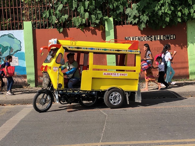
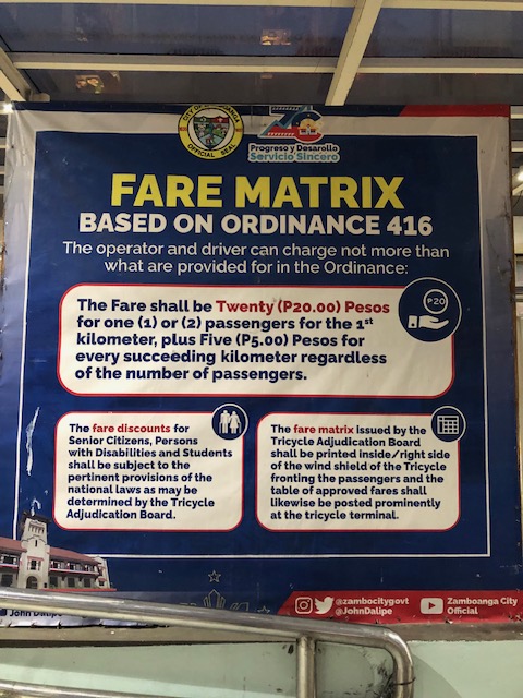 Simple fare calculation stated on the tarp. I assumed there were specific matrices posted in each tricycle but there was none since operations are free-for-all regardless of TODA in the city. That is, trikes in the city practically have no zones of operation where they are restricted or confined similar to what they have in other cities like Olongapo or Quezon City. In the latter, they can issue specific matrices or tables for the passengers’ reference much like what you have in jeepneys that have fixed routes. This can be confusing to passengers and creates situations that may lead to drivers taking advantage and overcharging passengers.
In a city like Zamboanga where there are many one-way streets, tricycle drivers can easily lengthen or appear to lengthen trips leading to overcharging of fares. Where tricycles do not have zones or areas of operations per TODA, this becomes the weakness or flaw even with ordinances in place for erring drivers and a simple fare matrix for passengers’ reference. Of course, regular commuters should be familiar with the usual fares they pay so perhaps that’s among the basis for knowing if you’re being overcharged. Visitors though will likely pay more if the driver consciously takes advantage of the situation. Again, this is a matter for enforcement of the ordinances passed by the city and an example of how such ordinances will be implemented.
–
Transport strike again?
There’s a 3-day transport scheduled starting tomorrow when the current President delivers the annual State of the Nation Address (SONA). The reason is reported to be to protest the government’s Public Utility Vehicle Modernization Program (PUVMP). I wrote a 4-part series on these strikes earlier this year and stated that such actions have been diminished over the years especially with government and its agents learning how to use conventional and social media to their advantage. That is, if you have a troll army at your disposal, you will definitely use it and take advantage of the commuting public’s growing perception (as influenced by government’s narratives) that the strikes are unnecessary and based on unfounded gripes. So the blame goes to the drivers and operators and the organizers rather than on the government agencies even despite the legitimate arguments by the former. In this case, it’s supposed to be about PUVMP but most commuters are indifferent about supporting the strike as it can be viewed as vs. modernization of public transport, which people link to improvement (i.e., modernization = improvement).
Here is the link to the last and concluding article in the series:
A brief history of transport strikes – Part 4: impacts and implications
I think my conclusion and the observations I presented in the series still holds. Given the resources and the alternatives to counter the potential impacts of a strike, going through with one presents a likely failure to get support from commuters in general.
–
On concert and sports event venues being accessible to transit
Among the major concert or sports event venues in the Philippines, perhaps the Araneta Coliseum is the most accessible to public transportation. Others like the SM Mall of Asia Arena in Pasay City is accessible to public transport but only for road-based modes. The Philippine Arena in Bulacan is accessible only by private transport or shuttle vehicles (basically also private as they are leased or rented). Compare this to say Singapore’s National Stadium, Tokyo Dome or Saitama Arena, which are all served by mass transit systems. It was so easy to go to the U2 concert in Singapore or Japan because of this. It was difficult for the same when they came to the Philippines because going to the Philippine Arena required a long drive both ways.
With all the fuss about Taylor Swift’s concert tour, I found this article about how fans or Swifties as they are called get to the concerts – they take public transportation:
Brady, T., Caldera, L. and Worthington, P. (July 14, 2023) “Transit Funding Problems Too Big Even for Taylor Swift to Solve,” Next City, https://nextcity.org/urbanist-news/transit-funding-problems-too-big-even-for-taylor-swift-to-solve?utm_source=Next+City+Newsletter&utm_campaign=c480374b80-DailyNL_2023_07_14&utm_medium=email&utm_term=0_fcee5bf7a0-c480374b80-44383929 [Last accessed: 7/19/2023]
To quote from the article:
“And how did the nation’s Swifties get to these concerts? As a recent Crain’s article explains, transit.
Fans took buses and trains to see superstar Swift, adding 43,000 bus and rail rides in Chicago and tripling the number of weekend riders in Atlanta. Her Philadelphia concerts in mid-May brought an estimated 27,000 additional riders to SEPTA’s (Southeastern Pennsylvania Transportation Authority) subway line next to Lincoln Financial field.”
If she held at least one concert here, I’m afraid that concert will generate more car traffic than transit ridership if held at the Philippine Arena. NLEX will definitely generate a lot of toll revenue but traffic will be hell for the event.
–
Learning to commute in Singapore
In a recent trip to Singapore, we took advantage of their excellent public transportation system to teach our daughter about commuting using public transport. It will be useful for future travels especially in countries we plan to visit that also have similar transit systems.
 |
| Descending to the subway station near our hotel |
 At the station level, one needs some sense of direction and the layout of the station to know where to get a card or tickets and where to enter the station towards the platforms.
 Station and train information are available and very visible in SMRT stations
 Network maps help one plan a trip including determining where you can transfer from one line to another. While there can be many transfer stations, the key is to determine the least number of stations as presumably this will lead to less travel time. Offhand, a familiarity with stations may also be useful to determine where it is easier to transfer (i.e., same platform for two lines rather than having to walk, ascend or descend to transfer).
 Singapore’s transit system employs ezlink cards for the convenience of commuters. We got one each and its nice that we got these cards with the Doraemon design.
It took only a couple of rides for our daughter to learn how to commute in Singapore. That’s how easy it was and it should be very similar if we’re traveling to Japan or Korea, even Europe at some point. The public transportation in cities in those countries are really good and easy to figure out and use. Hopefully, we can soon take her to learn how to use the LRT in Metro Manila and perhaps also the bus and jeepney. That will be an interesting experience.
–
Article share: What Is Bus Rapid Transit?
I found this short article defining and describing Bus Rapid Transit (BRT). I include this as a topic under public transportation in one of the graduate courses that I teach. Fortunately, I have materials for lecture coming from previous engagements concerning BRT including lectures by my former adviser who is an expert on public transportation and has studied the BRT in Curitiba, Brazil. Here is the article appearing in Planetizen:
Source: What Is Bus Rapid Transit?
Quoting from the article:
“Bus rapid transit, known as BRT, is a form of transit widely seen by transportation planning professionals and transit officials as a less costly alternative to light rail that offers a significant improvement over other fixed-route bus services that share lanes with regular traffic and makes bus service faster and more reliable.
BRT generally includes dedicated transit-only lanes or busways for at least part of the route, as well as prioritized traffic signal timing. BRT lanes are often located in the center of the roadway to limit interaction with cars, bikes, and pedestrians. In some cases, busways are elevated or underground.”
Definitions are good in that they provide us with a characterization of the system. There are many good examples of BRT particularly in South America (e.g., Curitiba and Bogota). These should be the models to replicate or adopt in Philippine cities rather than what local officials and their consultants propose and/or implement that are basically aberrations of the BRT concept.
–
Article on “Fair Share Transportation Planning”
I am sharing this new article from Todd Litman on fair share transportation planning. The content is relevant and very timely in the Philippines considering many people including and especially transport officials are struggling with the thought of allocating resources to provide or improve facilities geared towards more equitable transport systems (e.g., more facilities for active transport).
Here’s the summary as quoted from the article:
“To be efficient and equitable, a transportation system must serve diverse demands. A diverse transportation system allows travelers to use the most efficient option for each trip—safe walking and bicycling for local errands, efficient public transit when traveling on busy travel corridors, and automobiles when they are truly the most cost-effective mode considering all impact—and it ensures that people who cannot, should not, or prefer not to drive receive their fair share of public investments.
Current transportation planning practices are biased in various ways that overinvest in automobile infrastructure and underinvest in more affordable, inclusive, and efficient modes. It is time for planners to reconsider our analysis methods and funding practices to ensure that non-auto modes, and therefore non-drivers, receive their fair share of transportation resources.
This is not anti-car. Motorists have good reasons to support more investments in non-auto modes that reduce their traffic and parking congestion, reduce their chauffeuring burdens and crash risk, and provide better options when their vehicles are unavailable. Everybody wins from a more diverse and efficient transportation system.”
On San Francisco’s cable cars
Here a quick share of an article on San Francisco’s iconic cable cars:
Carren, D. (May 11, 2023) “Why SF cable cars are so iconic: a history,” The Bold Italic, https://thebolditalic.com/why-sf-cable-cars-are-so-iconic-a-history-895e30e50784 [Last accessed: 5/14/2023]
From the article:
“Though a scant remnant of what they once were, the three remaining lines are almost always packed with riders, running every 8 minutes for 16 hours a day, clanking along with a lurch’s awkward grace and an artful clattering. The crowd hangs tight to the handholds and the poles and their hats through hairpin turns, and a daring few lean out with one arm, wildly waving to signal all is still quite well.”
I have been to SF a few times and enjoyed using the cable cars among other modes to go around the city. In fact, in one of our stays in SF, we deliberately booked a hotel close to the end point of one of the lines so we can use it more frequently to go to downtown SF.
 San Francisco’s cable cars at the Hyde Street turnabout ca. 2011.
–
A vintage US Army Jeep – the ancestor of the jeepney
We were visiting the studio of a friend last weekend and learned that he was a history buff. He did historical reenactments as well as researched on militaria including the uniforms worn by combatants in World War II. The latter was part of his work towards more accurate uniforms being used for period films. A surprise for us was that he also collected vintage cars that included two US Army Jeeps and a truck that were parked in their garage.
 A US Army Jeep greeted us as we entered their studio premises
 The 4-cylinder engine of the Jeep
 Another view of the engine. Notice, too, the front grill of the vehicle.
 A second jeepney is parked behind the first. This second one had a canvass top on and a radio antenna that’s supposed to be original.
 There’s the steering wheel and the machine gun mount.
 The wipers whose design was retained by the jeepneys
I had always wanted to see an intact specimen of this jeep. The surplus units eventually were modified or customized to become the first jeepneys that seated 4 to 6 passengers at the back (they were shorter back then. The designs were based on the auto calesa, which were cars that were modified to become public transport vehicles with bench seats at the back. The rest, as they say, is history and we now still have what are termed as conventional jeepneys that now seat 16 to 24 passengers at the back of the driver.
–
On air quality in subways
I saw this article on Wired and immediately read it as the topic to me was interesting. I have been using when I lived in Japan in the 1990s and in Singapore in 2010-2o12. I have used the transit system in many other cities including in the US and Europe. And so the topic of air quality in subways (particularly the stations and inside the trains) got my attention. I guess this is not entirely an issue for ground-level and overhead systems like what most of Lines 1, 2 and 3 and the PNR are. Only Line 2 has one underground station (Katipunan Station) and perhaps has that issue. Here is the article about the air in subways:
Baraniuk (April 24, 2023) “The Filthy Truth About Subway Air,” Wired, https://www.wired.com/story/subway-air-health/ [Last accessed: 4/25/2023]
To quote from the article:
“The big unknown is whether all of this particulate matter is actually causing health problems for people. Millions of commuters use metro systems, in many cases for multiple hours a day, five days a week, for years on end. And thousands of transport workers spend even longer in the tunnels. But there are no widespread signs of severe or acute health problems among these populations, even if pollution levels in subways exceed recommended limits. Could there be more subtle, chronic effects, however—impacts on lung, brain, or heart function?”
Indeed, metros or subway systems have been operating for over a century and so far there is limited that we know about the health risks concerning their use by passengers. But this is something to keep in mind as the Philippines builds its first subway line in Metro Manila. The depots and the situation of workers thought may be a different matter. I recall one of my colleagues at the university doing a quick study of the Line 3 depot, which is underground (i.e., underneath the Trinoma Mall), and measurements showed the air quality to be quite bad. Imagine working there and being exposed to that everyday. Those conditions merit further study but require immediate action to improve working conditions considering the impact to health.
–
Motorela – Paratransit in Cagayan de Oro
Our recent trip to Cagayan de Oro reacquainted us with their paratransit. While they looked like tricycles at first glance, they are actually 4-wheeled. Instead of a motorcycle with side car (with one wheel), this is a motorcycle fitted with a body that has two wheels (total 4). These are called motorela, which look like the Thai tuktuk.

These can seat 9 passengers including the driver. The design though appears to put a lot of stress on the motorcycle due to the weight of the attachment plus the weights of passengers. Typical motorcycles are not built for these loads.
–
