
Home » Road Safety (Page 24)
Category Archives: Road Safety
Another look at Marcos Highway pedestrian overpasses – Part 2
I purposely didn’t include the overpasses at and near the Masinag Junction because I felt they deserved their own article. For one, the area will be the location of the future end station of the current LRT Line 2 Extension project. Here are a couple of photos of the overpasses in the area.
 Overpass at SM City Masinag – note the tall columns for the elevated tracks of Line 2. Will the Masinag Station be located that high or will it be at a lower level, perhaps closer to the SM City overpass?
The overpass at SM City Masinag is something that has been replicated in many other locations where an SM mall has been constructed. Note the similarity of the situation with the likes of SM City Iloilo, SM City Novaliches where SM built pedestrian facilities to allow for safe crossings between the mall and the area across from it along the highway. In many cases, it is the mall which provided the overpass in coordination with the local government unit and, I assume, the DPWH.
 Overpasses at Masinag Junction – there are actually 4 bridges here, each spanning one leg of the junction.
One of the intents for these is to eliminate at-grade pedestrian crossings at the junction. While crossing have been reduced significantly, there are still many “pasaway” who cross even when there is a green light for vehicular traffic along the leg they are crossing. Traffic enforcers here are quite lax about this and don’t seem to put in an effort to inform people about the overpass. There is no excuse for those who might claim they are too old or weak to climb the steps since the overpass has 4 working elevators for those unable to make the stairs. I noticed though that most of those using the elevators are able bodied people who probably are just too lay to take the stairs.
–
Another look at Marcos Highway pedestrian overpasses – Part 1
My daily commute allows me to have a look at the progress of the LRT Line 2 Extension construction. I also became curious about the situation of the pedestrian facilities along Marcos Highway particularly the crossings since many at first seemed to be affected by the elevated rail structure that was to be built. Now, we already have a good idea of the fates of these pedestrian overpasses. This article shows the conditions/situation of pedestrian overpasses (also called footbridges) along Marcos Highway. Most overpasses are not covered; exposing pedestrians to the elements. Most are also made of steel, which can be traced to the MMDA’s (and later the DPWH’s) preference for these structures.
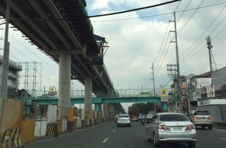 Overpass near Filinvest East-Vermont Park gates – the overpass actually is between a technical college and the commercial building across from it.
 The overpass across from Vermont Royale in front of a new Shell service station was actually among the newest facilities along Marcos Highway. Apparently though, it was built without considering the impending construction and design of the Line 2 extension. As such, the overpass needs to be modified or would have to be reconstructed elsewhere near the area.
 Overpass at Town & Country Executive Village that is also near the San Benildo School
 Overpass at Marcos Highway-Felix Avenue-Gil Fernando Avenue intersection – is probably the busiest among the pedestrian overpasses as it is at a busy junction where there are major commercial establishments (i.e., malls) and where many public transport routes converge.
 Robinsons Metro East overpass – this one also survived the clearance requirements with respect to the elevated superstructure for the Line 2 extension. However, since one of the two stations to be built will be nearby if not right across (part of the station at least) from the mall, then the station itself may function as an overpass.
 Overpass at De la Paz – note the ramp for bicycles and wheelchairs. This is one of the more bike- and PWD-friendly facilities along Marcos Highway. The slope is gentle enough for pedestrians, too, especially senior citizens who might have difficulty with steps.
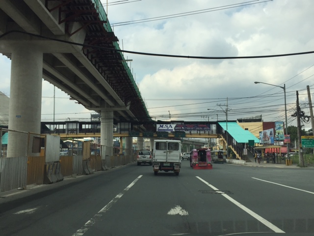 Overpass at Ligaya – this one also has ramps that make it easier for people to use to cross the busy highway. This will eventually be the closest overpass to the huge Ayala mall (Feliz) currently under construction at the Marikina side of Ligaya. I suspect that there might be a need for another overpass to be built with respect to the mall for one to directly serve the mall’s customers.
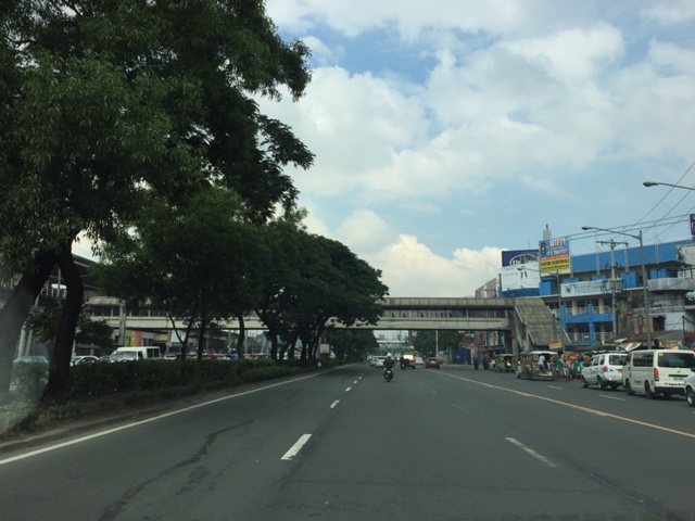 Line 2 Santolan Station overpass connects the Marcos Highway westbound public transport stop with the rail station along the eastbound side of the highway.
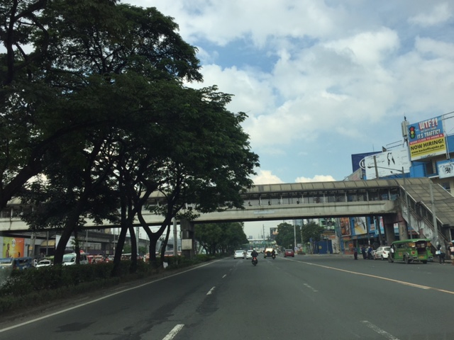 A closer look at the Santolan Station overpass, which is used by a lot of Line 2 passengers who cross the highway to continue on their journeys/commutes via train from their origins in Rizal, Marikina and Pasig. During the mornings, the observer will see a lot of jeepneys and UV Express vehicles emptying of passengers who cross the bridge to get to the station.
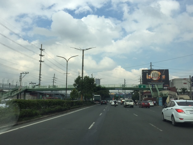 Santolan footbridge – this is actually more complicated than what is seems in the photo because the steel footbridge also connects to the SM City Marikina overpass (which is not included in this compilation but is visible in the photo). The footbridge branches to provide and almost direct connection between the mall and the Line 2 Santolan Station. That structure is shown at
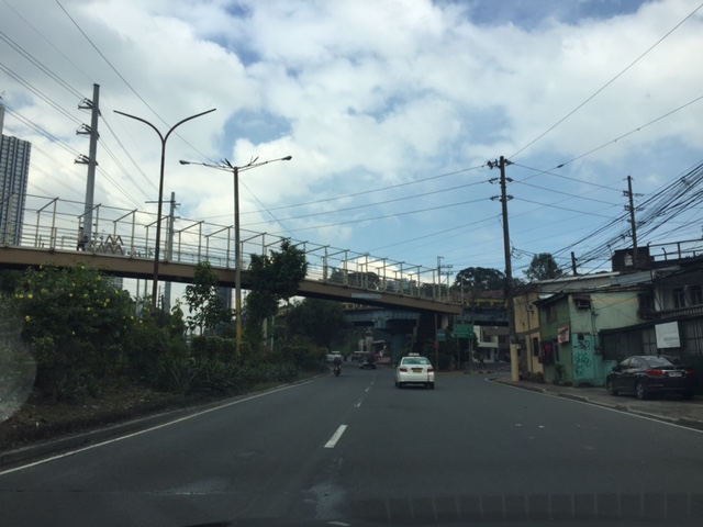 Monte Vista footbridge allows people to cross Marcos Highway (at its Marikina/Quezon City end) to and from A. Bonifacio Avenue, which is in Marikina City (Barangka)
More on pedestrian overpasses in the next post!
–
Mobilizing sustainable transport for development
The United Nations (UN) has recently published a new report on “Mobilizing sustainable transport for development” authored by a High Level Advisory Group on Sustainable Transport formed by the UN. The report and other resources may be found at the following website:
Secretary General’s High Level Advisory Group on Sustainable Transport
This is under the UN’s Sustainable Development Knowledge Platform. You can check out the other materials at the website. The UN has many initiatives on sustainable transport and has been very active in promoting or advocating for sustainable transport for a long time now. It is through the UN Centre for Regional Development (UNCRD), for example, that the Philippines and other ASEAN countries were able to formulate their national EST strategies. The new report continues on the UN’s commitment to promote sustainable transport to improve people’s lives around the world.
–
Tutubi bike share at BGC
I had been curious about the ADB-supported bike share initiative they called Tutubi since it was launched at the University of Sto. Tomas (UST) in Manila and at Bonifacio Global City (BGC) in Taguig. These have sophisticated portals where one can rent a bicycle by simply swiping or tapping your card unto the terminal. I finally noticed the bike station at Bonifacio High Street in BGC. I don’t know how I missed it since we are there weekly but then there are usually events in that area and the bike share station may have been obscured. Following are a few photos I was able to take as I watched our toddler walking about curiously and excited of the fountains and others she found interesting at High Street.
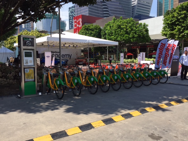 All the bikes seem to be here as not a slot was vacant.
 It seemed ironic to see not one bike in use against the backdrop banners of a popular motoring magazine.
 A closer look at the portal shows what looks like a new (unused?) facility.
It seems to me that there are few users of the Tutubi at least at Bonifacio High Street. I wonder if the bikes at UST are utilized more than the ones at BGC. I also wonder if UST is monitoring or studying bicycle use in its campus. Its use being limited within the premises of the campus sort of restricts users and diminishes utility. UST has a walkable campus and while its area is big (20+ ha) compared to other universities and colleges in the University Belt district, it is smaller beside Katipunan neighbors Ateneo De Manila University (80+ ha) and the University of the Philippines (493 ha). The latter two are also “walkable” with UP having more park-like features and open to the public.
UP Diliman has its own Bike Share program run by students and (I might come as biased) these seem to be popular on campus as I see many of the bikes used by students to go around from one building to another. UP Bike Share currently employs a more conventional system including subscriptions for frequent users. There is, however, a Department of Science and Technology (DOST)-funded project through the Electrical and Electronics Engineering Institute of UP Diliman that hopes to develop a more sophisticated system for managing and monitoring the bikes. That project has just started so we might wait 1 to 2 years to see its fruits.
–
Global Street Design Guide
Here’s another quick post. I just wanted to share this article with a link to a Global Street Design Guide that was developed by the National Association of City Transport Officials (NACTO) in the United States (US). It’s a nice guide that’s based on the experiences of many cities in the US including transformations that have made commuting more efficient, enhanced mobility and, most important of all, improved safety. Following is the link to a more direct link to the guide:
NACTO and the Global Designing Cities Initiative Release Global Street Design Guide
This will be a good reference in the Philippines where many cities are in need of transformation to address current and future challenges in transportation. Planners, engineers and students should read this and use it to make our streets safer and more efficient in terms of mobility for all. It would be nice to see fresh ideas on how we can improve our streets not just in Metro Manila but elsewhere across the country. Of course, it would be nice if city planners of local government units (LGUs) can adopt this design guide parallel with efforts to improve public transport services. It should be understood that simply imposing lane allocations and traffic flow policies (one way?), for example, will not solve problems but may create more. The approach should always be integrated, inclusive. In other words, complete.
–
Extreme commutes on a jeepney
I chanced upon this overloaded jeepney along Sumulong Highway. I counted eight people hanging behind the vehicle including the conductor. This is actually illegal and not just at present but always. The practice of hanging behind a jeepney is obviously unsafe and there is a high risk of people falling off. It would be a miracle not to have major injuries if one falls from the vehicle, and there is a high likelihood of fatality especially of a falling passenger gets hit by another vehicle trailing the jeepney.

‘Sabit’ or hanging on for a jeepney ride is more a necessity and males usually do this in order to get a ride home or to work. On many occasions, you will see men or boys in their office or school uniforms in the morning, braving it just so they won’t be late for work of school. While it is illegal, authorities seem to apprehend overloaded jeepneys from time to time (or according to some, just for show). I guess they, too, understand how difficult it is to get a ride and how this somehow allows people to get to their destinations. Surprisingly and despite reckless behavior among drivers, there seem to be few untoward incidents reported. Hopefully, public transport will improve so that people will not have to do such extreme commuting.
–
10 principles for sustainable urban transport
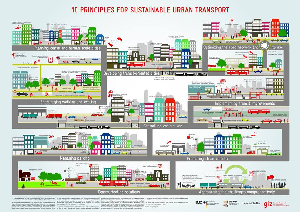
We start October with a graphic on sustainable transport. I first saw this shared on social media (FB) by the Clean Air Asia. The organizations behind it are on the graphic itself so I don’t have to list them down for the reader. This is a good material to share and learn from especially for those who don’t have a clear idea of what sustainable transport is and is all about. As they say, pictures paint a thousand words. And illustrations such as this convey so much about sustainable transport in the urban setting in layman’s terms.
–
Research topics for transportation engineering and planning for 2016-2017?
I observed from my site’s statistics that there have been a lot of interest on research topics in transportation engineering and planning. I regularly post on the undergraduate research topics our students have engaged in. At this point in the first semester of the current 2016-2017 academic year, topics have not yet been assigned and we have only learned how many students have been assigned to our research group. As such, we are still in the process of determining who takes on which topic. Following are topics we have identified in addition to those that had no takers the previous semesters:
Traffic engineering
- Anatomy of congestion along EDSA
- Anatomy of congestion along C-5
- Segregated lane for motorcycles
- Impacts of the MMDA’s truck lane policy along C-5
- Congestion study in the vicinity of UP Town Center
- Assessment of through traffic for the UP Diliman campus
Public transportation
- Connectivity study for UP AGT and MRT 7
- Feasibility of bus services beyond Masinag junction
- Characterization of Internal Public Transportation Operation in UP Diliman and Viability of Introduction of Electric Vehicles
- Modelling the Public Transport System of UP Diliman Campus Using CUBE Travel Demand Software
- Estimation of Passenger Demand for New Transit System for UP Diliman Using Discrete Choice Model
- Characteristics of motorcycle taxis in the Philippines [Habal-habal, skylab, etc.]
Road safety
- Severity of injuries of motorcycle riders (helmet and non-helmet users)
Pedestrian & non-motorised transport
- A study on walkability along Ortigas Avenue
- A study on the characteristics of bike share users in the UP Diliman campus
Transport & Environment
- Assessment of Roadside Air Quality along C.P. Garcia Avenue in the Vicinity of UP-ICE Compound
Other topics
- Study on the mobility of PWDs in Metro Manila
- Assessment of ridesharing in the context of sustainable transport
I’m sure there are other topics but I’m not aware of the specifics at present. Also, we welcome the ideas of our students should they already have topics in mind as long as these preferably fall under the research agenda of our Institute. The topics listed above may appear to be specific but these are still basically very general and can be refined after the students establish their scope and limitations. They can only do that once they have undertaken a decent enough literature review for them also to have a more firm appreciation of their chosen topics. I will post again on this later this year when students would have already put in substantial work on their research proposals (i.e., the objective for this semester).
–
Landslide in Antipolo
What’s been causing some traffic congestion along Ortigas Ave. Extension is the collapse of a side of the mountain at a section just before the Antipolo City arch (if you’re coming from Tikling Junction). The soil probably was already saturated after the past few days heavy rain and it didn’t help that the old wall holding the soil and consisting mainly of blocks was also already weakened (I am assuming that it was built following standards for such walls.).
 The area had been partially cleared of soil and rock, which initially blocked 2 lanes of the 4-lane road. Kudos to the DPWH for their work clearing part of the debris and easing traffic along this busy thoroughfare.
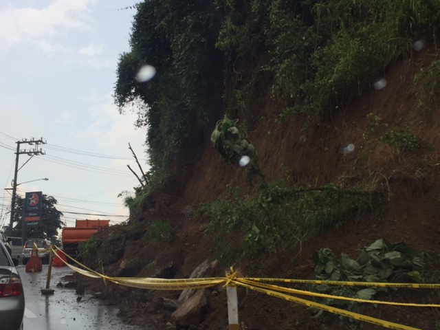 The wall at this section was completely obliterated revealing soil that appeared to be already unstable.
Hopefully, funds can be allocated very quickly in order to build the necessary slope protection. Perhaps the barrier should be designed to allow for more water to seep through without compromising the structure. Such weep holes are necessary especially given the saturated soils due to heavy rainfall experienced during this wet season and others in the future.
–
Motorcycle lanes along Sumulong Highway?
I noticed something along my commute and that is the newly marked pavement along Sumulong Highway at the section in Barangay Mambugan until Barangay Mayamot at Masinag Junction. I guess this is more likely part of Antipolo City’s initiative in managing motorcycle and tricycle traffic. In a meeting with the City Administrator, Robert Nacianceno, last year, he said that the city was moving towards improving road safety. That included addressing concerns about tricycle and motorcycle operations that has led to crashes and congestion. Motorcycle lanes designated by blue pavement markings are not new and likely was inspired by the MMDA’s initiatives along major roads in Metro Manila.
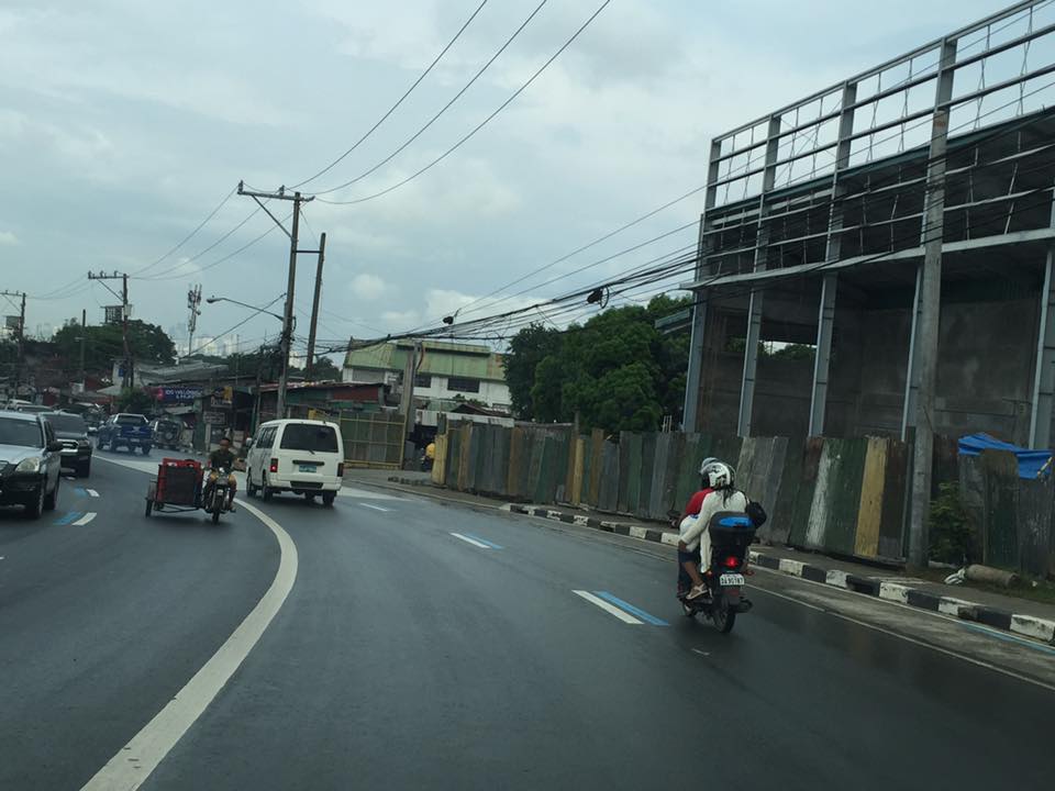 Motorcycle running along the designated lane
 The blue markings are present along both sides of Sumulong Highway
The real challenge with these motorcycle lanes would be on the enforcement. That is, how would the city be ‘encouraging’ motorcyclists and tricycle drivers to stick to the outer lanes of the highway. Such would require a tremendous effort for the city as they will definitely have to apprehend erring motorists and also clear the designated lanes of obstructions. Should this program be successful along Sumulong Highway, perhaps they should consider the same for Marcos Highway.
–
 Caught (up) in traffic