
Home » Road Safety (Page 32)
Category Archives: Road Safety
Let there be light
Driving home after our office’s Christmas Party, I couldn’t help but notice the difference in illuminations between sections of Marcos Highway from Santolan in Pasig City until Masinag in Antipolo City. The stretch from Santolan until Sta. Lucia Mall is relatively dark with the only light coming from vehicles or the establishments along the roadside. The vicinity of the LRT 2 Santolan Station benefits from the lighting of the elevated station, the pedestrian overpass and the medium-rise residential development nearby. It is actually quite dark right after the LRT 2 Station where vehicles stand along the roadside waiting for passengers coming out of the trains terminating at station. Some sections benefit from the presence of 24-hour gas stations and the Robinson’s and Sta. Lucia Malls near the intersection with Imelda Avenue. But for most sections, it is quite dark, which tends to discourage walking and cycling along the highway. The photo below that I quickly took with my phone pretty much describes the lighting conditions along Marcos Highway along a section that’s supposed to be a shared responsibility among the Cities of Pasig and Marikina. There are lamp posts along both sides of the road, courtesy of the rehabilitation works for Marcos Highway that was completed earlier this year. But all seem to be switched off.
 Typical dark section of Marcos Highway from Santolan to Imelda Avenue.
Meanwhile, quite noticeable is the illuminated stretch from Imelda Avenue to Masinag, where Marcos Highway intersects with Sumulong Highway. Lights from the lamp posts along both sides of the highway are all switched on, giving travelers (motorists, pedestrians and cyclists) the benefit of a well-lighted facility through which they could travel safely, at least from the perspective of illumination. One can actually turn off his headlights (though I don’t recommend it) and you won’t really notice the difference because of the lights from the lamp posts. The following photo is another quick shot taken right after the U-turn slot across from the Burger King branch along the highway. The section is within the limits of the Municipality of Cainta and further on, the City of Antipolo, both in Rizal Province and technically outside Metro Manila.
 Typical illuminated section of Marcos Highway
It has already been established that poorly lighted roads lead to road crashes even as it has been established that nighttime crash rates are higher than daytime rates (AASHTO, 2003). There is also evidence that fixed-source lighting can reduce the incidence of crashes particularly along urban streets where there are many intersections and major arterials such as Marcos Highway. In the Philippine setting, illumination also enhances safety and security for pedestrians and cyclists and would definitely encourage the development of a culture of walking. In the case of Marcos Highway, there are already pedestrian and cycling lanes separate from the carriageway. However, these are poorly illuminated along significant sections such as the Santolan to Imelda sections where perhaps people can have the option to walk to and from the LRT station. They are discouraged though because of the risks associated with dark places and so end up waiting for a jeepney ride instead of walking what is actually an acceptable (walkable) distance. Perhaps Pasig and Marikina, two cities currently advocating walking and cycling, should look into this issue in coordination with the DPWH, which has jurisdiction over the national highway. If Rizal’s Antipolo and Cainta can do it, I don’t see why Marikina and Pasig can’t.
–
On pedestrian overpasses again
Pedestrian overpasses in Metro Manila are of various designs. The older ones are mostly concrete structures that were not designed to consider the needs of senior citizens or persons with disabilities (PWDs). Often the stairs are relatively steep and each step can be quite high. More recent ones, particularly those constructed by the MMDA in the last administration were steel structures. The first generation where constructed similarly as their concrete versions, with little consideration to the elderly and the physically-challenged. Many of these overpasses even got flak from women’s groups as the steps featured slits through which women can be taken advantage of by peeping toms. And so some of the “offending” overpasses had their stairs retrofitted to provide some cover for people using these facilities.
A good feature of more recent overpasses constructed has been ramps that allow easier access by persons with disabilities and cyclists. Most new overpasses in Metro Manila also have less steeper stairs and others even have landings to allow people to have some pause while climbing up or down the overpass. Following are a few photos of overpasses along Marcos Highway including one connecting a major shopping mall to the LRT Line 2 Santolan Station.
 Overpass along Marcos Highway in Pasig City featuring a ramp that can also be used by cyclists and persons with disabilities.
 “Conventional” overpass along Marcos Highway – there are no ramps but the stairs are not as steep as the older ones.
 Overpass connecting a major shopping mall to the LRT Line 2 Santolan Station
While such overpasses are necessary along wide roads with heavy motor vehicle traffic, similar facilities are not usually recommended for narrower streets where motorized traffic is manageable. There are discussions now that call for pedestrians to have the right of way along streets. Such discussions have basis given pedestrians attempting to cross at designated areas (definitely not the jaywalkers) have difficulty crossing as motor vehicles disregard them, with some seemingly attempting to sideswipe people (nananadya?). The rule should be that once a pedestrian steps on the pavement at a zebra crossing or crosswalk, vehicles should give way to them. Many drivers and riders are oblivious to this rule and it is not enforced by the MMDA or police. They should, in order to effect behavior change in motorists and to ensure the safety of pedestrians.
–
Mobility for all?
We chanced upon the fellow shown driving an electric vehicle below with what was apparently his wheelchair mounted behind the vehicle. And then I remembered seeing other people in wheelchairs traveling along the traffic lanes of similar streets, and exposed to the high risks of being sideswiped or bumped by motor vehicles. These and other persons with disabilities (PWDs) are among what we usually categorize as transportation poor or those who are marginalized when traveling. Marginalization comes in many forms including the lack of or inadequate infrastructure and facilities for PWDs. Sidewalks are usually narrow, making it difficult even for able people to use, and definitely inaccessible to persons needing the space to move about.

I remember that Tahanang Walang Hagdanan (translated Home without stairs or steps) is located in Cainta, Rizal. We used to see PWDs on their wheelchairs traveling along Bonifacio Avenue in the poblacion to go to church on Sundays. Often, jeepneys, buses and cars come very close to them that you might wince at the near misses of what could easily be a tragedy just waiting to happen given the odd mix of people on wheelchairs mixed with motorized traffic along the carriageway. The local government should have exerted more efforts to put up facilities adequate for the needs of pedestrians in general and PWDs in particular; the latter considering the significant number of constituents requiring such facilities. On a map, you can even see that Tahanang Walang Hagdanan is just beside the Cainta Local Government Complex. I believe the provision of basic facilities to enhance the safety and mobility of PWDs is just one example of what a city or town should be doing towards realizing inclusive transport or inclusive mobility at their level. It would definitely go far in promoting people friendly, sustainable transport for all.
–
Railway safety in the Philippines
As the Philippine National Railways (PNR) attracts more passengers and (currently) more support translating to more resources, it is hoped that the company will finally take off and perhaps help improve public transportation and commuting in general. The PNR has been experiencing a renaissance of sorts with the increased frequency and capacity for its commuter line. This, despite still many limitations pertaining to hardware such as its rolling stock and railway tracks (i.e., the PNR has double tracks only along its line Caloocan to Alabang, the rest is single track). The acquisition of newer trains for the commuter line and the upgrading of railway tracks helped revive flagging ridership though service frequencies are still quite limited due to the limitations mentioned. Among the major issues the PNR is still facing at present are encroachments to its right-of-way and safety concerns at the many level crossings along the tracks. While there have been efforts to improve safety by adding devices such as barriers and posting personnel to manage road traffic when trains are passing through, the system is still wanting in terms of safety and there has been a rash of incidents along its commuter and Bicol lines involving road vehicles and pedestrians. Of course, these are not all the PNR’s fault considering there are many “pasaway” people who still insist on crossing the tracks despite warnings of an arriving train. I am featuring below some aspects of rail and road safety that my students have collected during their research on the state of the PNR commuter line.
 PNR Commuter Line train
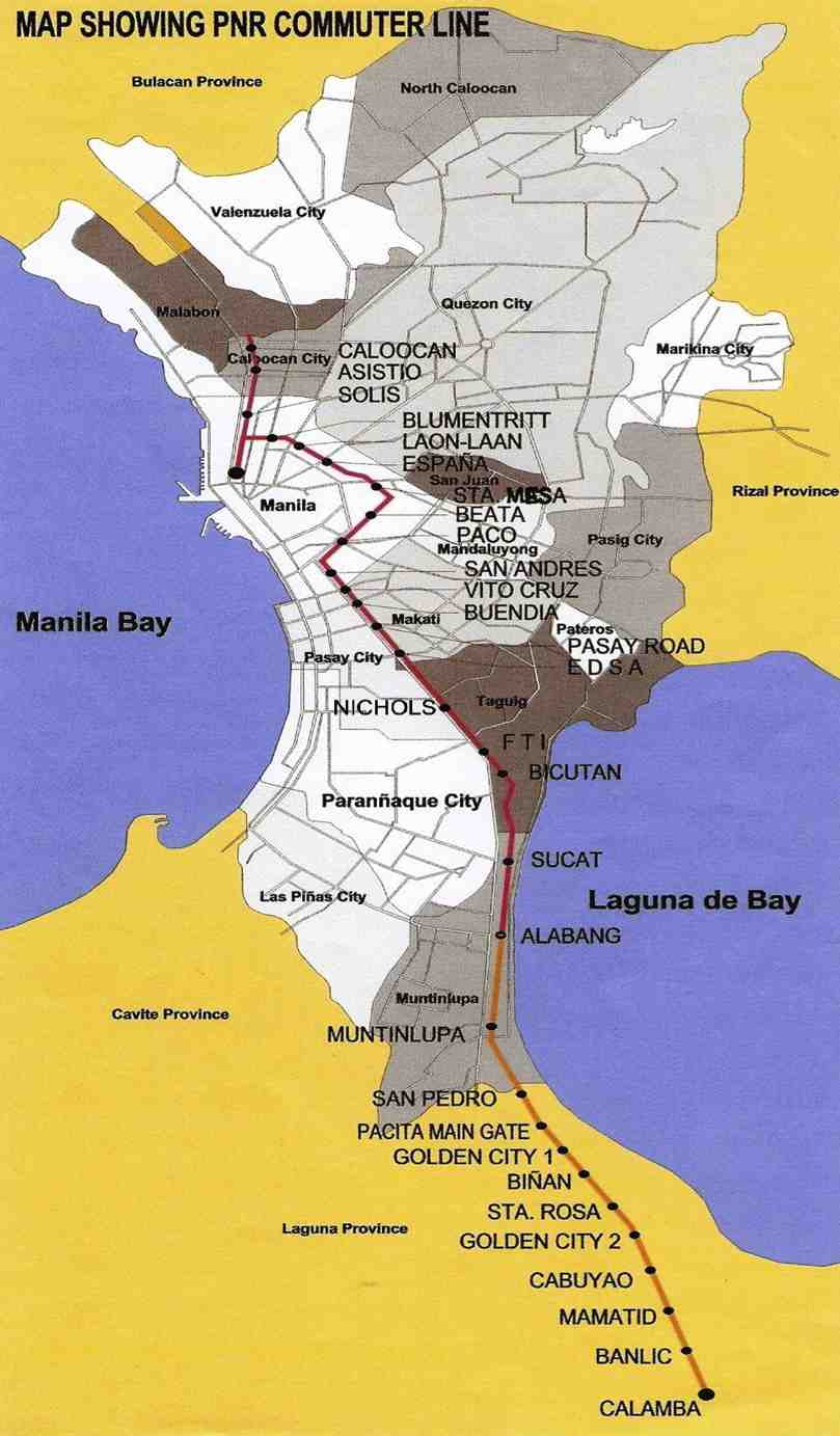 The PNR Commuter Line – indicated in red is the double track (two-way) stretch and in orange is the single track (one-way) part of the line that ends in Calamba. The line to Bicol is also single track.
 Map showing the list of level crossings along its Commuter Line between Caloocan, Manila and Calamba
 The PNR defines a diamond-shaped clearance at all level crossings. The diagram above was secured by my students from the PNR, clearly illustrating the area within which there should be (ideally) no obstructions.
 The concept of diamond clearance as applied to level crossings at Malugay, Buendia (Gil Puyat) and Dela Rosa in Makati City.
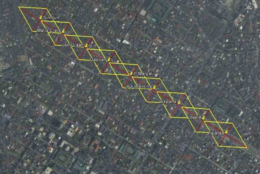 The diamond clearance concept as applied along level crossings in Manila.
It is unfortunate that there was a recent derailment of a train in Bicol due to the failure of the railway tracks’ (soil saturation due to heavy rains). This incident will surely set back services until the section has been repaired and perhaps reinforced to prevent such happening again in the future. I always imagine the PNR’s Bicol Express during its glory days as my father has related stories of how good its service was then. This romanticized idea of rail is still alive today and the addition of sleeper and air-conditioned cars have attracted tourists visiting the Bicol Region to use the PNR. It is hoped that this could be sustained and services expanded in the near future. Of course, investments should go into make the Bicol Express line double track in addition to more trains to accommodate two-way traffic. I wouldn’t dream yet of high speed rail for this corridor but decent train services should be able to compete with buses and give travelers a safe and efficient option for travel over land.
–
Some thoughts on transport and traffic while commuting between Cainta and Antipolo
Commuting from the Ortigas (Cainta) end of Imelda Ave. to its other end at Marcos Highway (near where Pasig, Marikina, Cainta and Antipolo meet), one should be able to observe and make a quick assessment of the positives and negatives of our local transport system. While there are more negatives at Cainta Junction and along Imelda Avenue, Marcos Highway definitely has improved particularly in terms of walkability. It is a commute that I have taken so many times since my childhood days and I can only now remember times when one could walk safely from one end to the other when there were far less vehicles than the volume that flows along Imelda Ave. these days.
Junction is still quite the mess despite some road widening at the intersection owing to various factors including the fact that the intersection simply cannot handle the volume of vehicles using it even after the elimination of some turning movements from Ortigas Ave. in favor of U-turns particularly for traffic coming from the eastbound side of Ortigas. It seems the traffic signal settings can no longer handle peak period traffic and manual traffic management probably aggravates the situation especially when enforcers employ the buhos technique of trying to dissipate as much of the queued vehicles per approach or movement. The latter technique does not take into consideration that the longer a movement or group of movements are allowed to move, there are corresponding build-ups in traffic along all other approaches. It is a vicious cycle (pun intended) that is supposed to be addressed by an optimally times signal system. Saturated conditions, though, are inevitable due to the sheer volume of vehicles using the intersection given that Junction is a catchment for vehicles from Rizal Province that ultimately uses Ortigas Ave. to head into Metro Manila in the mornings. The reverse is true in the afternoon to evening periods.
Imelda Avenue, which was also known for a time as Francisco Felix Ave., is plagued congestion due to notoriously bad pavement conditions, so many median openings, and high vehicle trip generation rates from the many residential subdivisions or village along the road. The pavement conditions are due mainly to damage brought about by trucks and, during the wet season, frequent flooding along many sections of the avenue. Bad pavement conditions and flooded streets significantly slow down traffic as Imelda Ave only has two lanes along each direction and is divided by a narrow median island that’s just enough for a few plant boxes and lamp posts.
There are mostly middle class subdivisions including the large Vista Verde, Village East, Karangalan, and Pasig and Cainta Green Parks along the road. There is also a DMCI medium rise development has its main access road also connecting to Imelda Ave. These villages generate much vehicle traffic and each have their own median openings that practically function as intersections along the entire stretch of the avenue. These openings create a lot of conflict between through traffic and vehicles entering and exiting the villages, especially those taking left turns to or from their gates.
While there are commercial establishments along the avenue, most were small and traffic generation characteristics were not so significant as to cause severe congestion. The first major generator in the middle of the avenue was a branch of the membership-concept Makro supermarket cum depot. Makro generated significant traffic but did not cause much congestion along the stretch in front of the Village East gate. It was eventually acquired by commercial giant SM and the branch is now an SM Supercenter that seems to be generating much more traffic than Makro did at its peak. While traffic studies are usually the norm before such developments are constructed given the trips attracted by SM, the congestion experienced along Imelda Ave has been reported to be generally un-managed despite the need for more disciplined loading and unloading by public transport, pedestrian movements and vehicle entries and exits.
Jeepneys are the main public transport mode along Imelda Ave. although there are tricycles serving the various subdivisions that often not only cross the road but also travel along Imelda Ave. for short distances. I remember in the 1970’s and early 80’s that the tricycles used to be the primary mode of transport from Junction and the Cainta Public Market as Imelda was not yet connected to the still to be completed and unpaved Marcos Highway. There was even a Metro Manila Transit Corp. bus service (probably missionary route and with low frequency of service) along Imelda Ave. that turned around near Kasibulan Village, one of the first subdivisions in the area. Many jeepneys are noticeably the patok or popular type known for their loud stereos and reckless driving. Still, there are the smaller, older jeepneys whose route connects either ends of Imelda Avenue. Most patok jeepneys are from the many longer routes between Rizal towns and Cubao overlapping along Imelda Ave (e.g., Angono-Cubao, Antipolo-Cubao, Binangonan-Cubao, Taytay-Cubao, etc.).
–
Professorial Chair 2012 presentations on Transportation
The Transportation Engineering Group of the Institute of Civil Engineering of the University of the Philippines Diliman held a special session for its Professorial Chair Lectures last August 10, 2012 at the Toyota Training Room of the National Center for Transportation Studies. Four lectures were delivered by ICE faculty members who are also Research and Extension Fellows at the NCTS. Following are a few photos taken during the colloquium.
 Dr. Sean Palmiano presenting on the Investigation of Road Crash Causal Factors in Metro Manila (DMCI Developers Professorial Chair)
 Dr. Karl Vergel presenting on the Design of Traffic Signal Timing and Traffic Impacts of the Re-Introduction of Traffic Signal Control at the Intersection of the University Avenue and Commonwealth Avenue (Maynilad Professorial Chair)
 Dr. Ric Sigua presenting on Microscopic Simulation: A Tool for Evaluation of Traffic Schemes (Prof. Emeritus Norbert S. Vila Professorial Chair)
 Dr. Regin Regidor presenting on Revisiting the Costs of Traffic Congestion in Metro Manila and their Implications (Pozzolanic Philippines, Inc. Professorial Chair)
 Audience consisting of various participants including those from the DPWH, DOTC and MMDA who were invited for the colloquium.
 Graduate students and technical staff from the College of Engineering and the National Center for Transportation Studies also attended the lectures. Unfortunately, classes were suspended that week due to the monsoon rains that resulted in widespread flooding in Metro Manila so undergraduate students were not able to attend the colloquium.
The presentation files may be found in a previous post where links for downloading are provided. These may also be found in the NCTS website.
–
Sumulong Highway: Marikina to Masinag
Sumulong Highway stretches from its intersection with A. Tuazon Ave. and A. Bonifacio Ave. in Marikina City, Metro Manila to the intersection with the Taktak Road or M.L. Quezon Ave. in Antipolo City in the Province of Rizal. It serves both as an arterial (for Marikina and Antipolo) and a feeder (with respect to Marcos Highway).
The following photos show the stretch from Marikina to Masinag that shows typical conditions along the highway. These conditions are quite different from those along the stretch from Masinag to Taktak Road in upper Antipolo City.
 Sumulong Highway has a total of 4 lanes (2 per direction) but a lack of pavement markings make it difficult to ascertain the center of the road and the space allocation for traffic. This makes travel less safe as motorists assume they are traveling along the correct space on the road.
 The asphalt-surfaced road has no lane markings but has very good pavement conditions. There is also significant on-street parking as most establishments along the highway have no adequate off-street parking spaces. The section shown above is right in front of a sabungan or coliseum for cockfights.
 There are pedestrian crossings though, near intersections and where there are schools along the highway.
 Only the traffic lanes have asphalt overlay, the shoulders have the concrete surface exposed thereby distinguishing them from the traveled way.
 The shoulders are used as parking spaces for establishments along the highway as shown in the photo. Such practices are also common along national highways around the country.
 Even the barangay hall of Bgy. Mayamot utilizes road space for parking as shown in the left. The Mayamot Barangay Hall is see on the left in the photo. This effectively reduces road capacity leading to traffic slowing down at such sections.
 Another pedestrian crossing, this time in front of a public school right after the barangay hall.
 Some sections have sidewalks for people to walk along but these are also usually blocked or occupied by stuff from the establishments along the street.
 Waiting shed along the highway. I could not say its typical because the more recent ones usually have names or initials of politicians on them. This shed is likely to be old and uses clay tiles for roofing.
 There are also tricycles along the road due to the sidestreets and subdivision entrances connecting to the highway. Public utility tricycles are supposed to be prohibited from using national roads but are common in most provincial areas and CBDs where they are the main mode of transport. In this case, tricycles should be prohibited from using the highway as they are already competing with jeepneys, serving larger areas aside from what should be individual subdivisions or residential districts.
 There are many auto repair and supply shops along this stretch of Sumulong Highway. Such shops typically have many customers who also park along the highway, often occupying road space and causing congestion.
 Approaching the Masinag junction, which is the intersection of Marcos and Sumulong Highways, one sees more commercial establishments on either side, mostly small stores or shops. At the junction is the Masinag Wet Market, which is now in decline after major commercial developments have been constructed in the area including the most recent SM City Masinag.
 Steel barriers placed along the center of the highway to discourage jaywalking – some barriers have been moved by pedestrians to create space for illegal (and risky) crossings such as what is seen just downstream in the middle of the photo (notice the person with the red umbrella?).
 Barriers forcing all traffic to turn right to Marcos Highway – seen across is the approach of Sumulong Highway from Antipolo
Portions of this section of Sumulong Highway are prone to flooding including the intersection with V.V. Soliven Avenue, which leads to SSS Village and other subdivisions. The more recent floodings were due to the heavy monsoon rains from a couple of weeks ago that effectively isolated residential areas in Marikina and Antipolo as vehicles could not exit the subdivisions to major roads like Sumulong and Marcos Highways. It’s quite interesting to note that the drainage systems along these roads including Sumulong have not been upgraded to be able to accommodate run-off from what is turning to be heavier rains due to climate change. Thus, it may be expected that the same sections will be flooded should there be heavy rains particularly due to typhoons and other major weather systems affecting Metro Manila and its environs.
–
Professorial Chair Lectures on Transportation Topics – 2012
The College of Engineering of the University of the Philippines Diliman recently held its Professorial Chair Colloquium where lectures were delivered by faculty members from the various institutes and departments comprising the college. Four lectures were delivered last August 10, 2012 at a special session held at the Toyota Training Room of the National Center for Transportation Studies. The lectures were on transportation topics and presented by faculty members of the Institute of Civil Engineering who are also Fellows at the NCTS. Following are the lectures and the presentation files in PDF:
Palmiano, H.S.O., Investigation of Road Crash Causal Factors in Metro Manila, DMCI Developers Professorial Chair: Road Safety Researches HSOPalmiano 10Aug2012
Vergel, K.N., Design of Traffic Signal Timing and Traffic Impacts of the Re-Introduction of Traffic Signal Control at the Intersection of the University Avenue and Commonwealth Avenue, Maynilad Professorial Chair: Traffic Signal Timing KNVergel 10Aug2012
Sigua, R.DG., Microscopic Simulation: A Tool for Evaluation of Traffic Schemes, Prof. Emeritus Norbert S. Vila Professorial Chair: Traffic Simulation RDGSigua 10Aug2012
Regidor, J.R.F., Revisiting the Costs of Traffic Congestion in Metro Manila and their Implications, Pozzolanic Philippines, Inc. Professorial Chair: Revisiting Costs of Congestion JRFRegidor 10Aug2012
–
Marcos Highway Bikeways and Walkways
I have written about the need for pedestrian facilities in previous posts. These include walking as a mode of transport, walkability in the Philippines, and even some personal experiences. There is no doubt about how important pedestrian and bicycle facilities are in order to promote walking and cycling as environment-friendly, healthy, and therefore sustainable modes of transport. Cities and towns where people walk and cycle are among the most healthy and perhaps vibrant places in the world. Walking outdoors, in fact, should be promoted if not encouraged (i.e., its difficult to encourage if there are no facilities, and health and safety are concerns) in cities where tourism is also being promoted as it can be used as an indicator for how easy it is to go around the city or town and perhaps how clean the air is in the area.
Following are a few photos I managed to take along Marcos Highway that show the newly designated bikeways apportioned from the sidewalk that was constructed along with the rehabilitated carriageway. There are bikeways on both sides of the highway as what used to be the open channel drainage was replaced by culverts and the sidewalks where built on top. In order to enhance the safety of pedestrians and cyclists, concrete barriers were placed along the road margins just above the curbs. The barriers actually work in another way, preventing or discouraging pedestrians or cyclists from wandering into the traffic lanes of this busy thoroughfare.
 The white line delineates the bikeway, which is the lane along the curb, from the pedestrian walkway that is on the inner side of the path. This can be a bit confusing and creates conflicts between pedestrians and cyclists as the parts of the roadside are also designated as bus/jeepney stops.
 Obstructions? – the bikelane runs smack into the staircase of the pedestrian overpass while the pedestrian path leads to electric posts. Such are issues that are also present along the more established bikeways of Marikina City.
 Too many signs? – from this view, there seems to be a lot of signs along the bikeway, appropriate perhaps in order to inform motorists, pedestrians and cyclists about the facilities. The signs are also useful for enforcement as Marikina City, for example, is strictly enforcing its policies against parking and other obstructions along the bikeway. Unfortunately, Pasig, Cainta and Antipolo are lax in their responsibilities to clear the bike and pedestrian paths from obstructions.
 Which direction? – the bike path markings state the direction for flow. Such is at best a suggestion as it is quite difficult to enforce one way flow for cycling. It must be made clear that the bikeway is mainly for commuting or utilitarian rather than for recreational or sporting purposes. Speeds should be slow enough for cyclists and pedestrians to co-exist and perhaps share space for two-way flow.
 All clear – the bike path is good enough even despite it going along so many driveways due to the nature of the developments along Marcos Highway. The bike path in front of the Metro East mall can be filled with commuters waiting to catch a ride and won’t be passable to cyclists especially during the afternoon to evening.
 Unfortunately, crossing the highway is another challenge for cyclists as the steps for most overpasses along Marcos Highway are quite steep. There are at least 3 that were designed to have ramps (the Imelda Ave/A. Tuazon, Dela Paz and Ligaya overpasses have ramps) for bicycles and wheelchair access).
 Establishments along highway can pitch in by ensuring the bike and pedestrian paths are clear of obstructions including parked vehicles. Incidentally, there is one gas station along Marcos Highway that is also a depot for taxis where the latter seem to always occupy the sidewalks. I have seen Marikina staff flagging them for disrespecting the right of way of pedestrians and cyclists but they seem to have some difficulty in clearing the area of parked vehicles. (Note: The Dela Paz pedestrian overpass is visible downstream.)
The pedestrian and bicycle facilities along Marcos Highway will certainly go a long way in promoting walking and cycling. At both ends of the highway though, at the Masinag junction at the eastern end and Santolan in the west, there are issues pertaining to continuity as both bikeways and walkaways disappear and pedestrians and cyclist would suddenly have to contend with mixing it up with motor vehicles along the carriageway should they want to continue in their travel. This issue of continuity should be addressed both by policy and the provision of suitable facilities for cycling and walking.
Perhaps something to think about is the realization of a link between the Marikina Bikeways, the Marcos Highway bike paths and UP Diliman’s bicycle lane along its academic oval via Aurora Boulevard and Katipunan. This can eventually be linked to the wide sidewalks along Commonwealth Avenue that can also be apportioned for pedestrians and cyclists. Perhaps such an integrated network covering parts of Quezon City, Marikina City, Pasig City, Cainta and Antipolo City can be realized quickly with enough effort from the respective local governments and maybe with a little help from the private sector including schools and commercial establishments along the network.
–
Transportation-related lectures at the UP College of Engineering 2012 Professorial Chair Colloquium
The College of Engineering of the University of the Philippines Diliman will be holding its Professorial Chair Colloquium for 2012 on July 30, 2012 at the Melchor Hall and the UP Alumni Engineers Centennial Hall at the UP Diliman campus. Among the topics under many disciplines of engineering are several lectures on transportation. These are the following and mainly under three departments of the college.
Institute of Civil Engineering [P & G Room, Melchor Hall]
- “Investigation of Road Crash Causes in Metro Manila,” Dr. Hilario Sean O. Palmiano, DMCI Developers Professorial Chair [8:30 – 8:50 am]
- “Design of Traffic Signal Timing and Traffic Impacts of the Re-introduction of Traffic Signal Control at the Intersection of the University Avenue and Commonwealth Avenue,” Dr. Karl B.N. Vergel, Maynilad Professorial Chair [8:50 – 9:10 am]
- “Microscopic Simulation: A Tool for Evaluation of Traffic Schemes,” Dr. Ricardo G. Sigua, Prof. Emeritus Norbert S. Vila Professorial Chair [9:10 – 9:30 am]
- “Revisiting the Costs of Traffic Congestion in Metro Manila and Their Implications,” Dr. Jose Regin F. Regidor, Pozzolanic Philippines, Inc. Professorial Chair [9:30 – 9:50 am]
Department of Mechanical Engineering [Maynilad Room, Melchor Hall]
- “Performance And Emission Characteristics of a Direct Injection Diesel Vehicle with Different Blends of CME Biodiesel,” Dr. Edwin N. Quiros, Emerson Professorial Chair in Mechanical Engineering [9:30- 9:50 am]
- “Design and Local Fabrication of an Energy- Efficient Electric Vehicle,” Asst. Prof. Joseph Gerard T. Reyes, Emerson Professorial Chair in Engineering [10:30 – 10:50 am]
Department of Chemical Engineering [Maynilad Room, Melchor Hall]
- “Co-Production of Alternative Fuels for the Philippines,” Dr. Rizalinda L. De Leon, Semirara Professorial Chair in Engineering [10:50 – 11:10 am]
The lectures are all open to the public and will be held from 8:30 AM to 12:30 PM. There are 8 lecture groups that are assigned to 8 venues at Melchor Hall and UPAE Centennial Hall. Melchor Hall is located at the university core along the Academic Oval while the UPAE Hall is located along Velasquez Street beside the EEE Institute Building and across from the National Institute of Geological Sciences (NIGS).
–
